Bridge Statistics for Fremont, North Carolina (NC)
Condition, Traffic, Stress, Structural Evaluation, Project Costs
- National Bridge Inventory (NBI) Statistics
- 21Number of bridges
- 328ft / 99.8mTotal length
- 101,830Total average daily traffic
- 21,391Total average daily truck traffic
- National Bridge Inventory (NBI) Registered Bridges for Fremont
- No street view available for this location
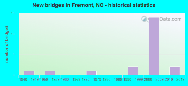
- New bridges - historical statistics
- 11940-1949
- 11950-1959
- 11970-1979
- 21990-1999
- 142000-2009
- 22010-2019


- Bridge Condition - Deck
- 25.0%Very good
- 50.0%Good
- 25.0%Satisfactory

- Bridge Condition - Superstructure
- 33.3%Very good
- 50.0%Good
- 16.7%Satisfactory

- Bridge Condition - Substructure
- 25.0%Very good
- 58.3%Good
- 16.7%Fair

- Bridge Condition - Channel
- 83.3%Good
- 8.3%Fair
- 8.3%Poor

- Bridge Condition - Culverts
- 66.7%Satisfactory
- 33.3%Fair
Find on map >> Show street view
Structure Number: 790097, Location: 1.1 MI.E.JCT.SR1400 (Lat: 35.457094, Lng: -77.533253), Route carried "on" structure: State highway 1401, Year Built: 1976, Status: Open, Structure Length: 0.82m (2.69ft), Average Daily Traffic: 700 (year 2015), Truck Traffic: 6%, Average Future Daily Traffic: 1,400 (year 2025), Design Load: HS 20+Mod, Features Intersected: POLE CAT CREEK
Minimum Vertical Clearance: 30+ m (98+ ft), Kilometerpoint: 0.000, Lanes on structure: 2, Owner: State Highway Agency, Approaching Roadway Width: 5.1m (16.7ft), Material/Design: Steel, Design/Construction: Culvert, Number Of Spans In Main Unit: 3, Length of Maximum Span: 2.1m (6.9ft)
Condition: Channel: Fair, Culverts: Fair, Operating Rating: 89.8 metric tons, Method Used To Determine Operating Rating: Load and Resistance Factor (LRFR), Inventory Rating: 89.8 metric tons, Method Used To Determine Inventory Rating: Load and Resistance Factor (LRFR), Structural Evaluation: Somewhat better than minimum adequacy, Waterway Adequacy: Better than present minimum criteria, Approach Roadway Alignment: Equal to present desirable criteria, Designated Inspection Frequency: Every 24 months, Underwater Inspection Frequency: Every 60 months, Inspection Date: January 2022, Underwater Inspection Date: January 2022
Find on map >> Show street view
Structure Number: 1910021, Location: 0.10 MI E JCT SR 1378 (Lat: 35.561050, Lng: -78.021864), Route carried "on" structure: State highway 222, Year Built: 2007, Status: Open, Structure Length: 2.74m (8.99ft), Average Daily Traffic: 2,100 (year 2019), Truck Traffic: 7%, Average Future Daily Traffic: 4,200 (year 2040), Design Load: HS 20+Mod, Features Intersected: GREAT SWAMP
Minimum Vertical Clearance: 30+ m (98+ ft), Kilometerpoint: 0.000, Lanes on structure: 2, Owner: State Highway Agency, Approaching Roadway Width: 7.3m (24.0ft), Material/Design: Prestressed concrete, Design/Construction: Box Beam or Girders - Multiple, Number Of Spans In Main Unit: 1, Length of Maximum Span: 26.2m (86.0ft), Curb-To-Curb Width: 12.7m (41.7ft), Out-to-Out Width: 13.7m (44.9ft)
Condition: Deck: Very good, Superstructure: Very good, Substructure: Very good, Channel: Good, Operating Rating: 89.8 metric tons, Method Used To Determine Operating Rating: Load Factor (LF), Inventory Rating: 58.9 metric tons, Method Used To Determine Inventory Rating: Load Factor (LF), Structural Evaluation: Equal to present desirable criteria, Deck Geometry: Equal to present minimum criteria, Waterway Adequacy: Better than present minimum criteria, Approach Roadway Alignment: Equal to present desirable criteria, Designated Inspection Frequency: Every 24 months, Inspection Date: December 2021, Deck Structure Type: Concrete Precast Panels, Wearing Surface/Protective System: Wearing Surface: Bituminous
Find on map >> Show street view
Structure Number: 1910037, Location: 0.5MI. S. OF JCT. SR1538 (Lat: 35.511739, Lng: -77.948361), Route carried "on" structure: State highway 1537, Year Built: 2010, Status: Open, Structure Length: 3.65m (11.98ft), Average Daily Traffic: 2,600 (year 2012), Truck Traffic: 6%, Average Future Daily Traffic: 5,200 (year 2040), Design Load: HL 93, Features Intersected: NAHUNTA SWAMP
Minimum Vertical Clearance: 30+ m (98+ ft), Kilometerpoint: 0.000, Lanes on structure: 2, Owner: State Highway Agency, Approaching Roadway Width: 9.1m (29.9ft), Material/Design: Prestressed concrete, Design/Construction: Slab, Number Of Spans In Main Unit: 3, Length of Maximum Span: 16.4m (53.8ft), Curb-To-Curb Width: 9.1m (29.9ft), Out-to-Out Width: 10.0m (32.8ft)
Condition: Deck: Very good, Superstructure: Very good, Substructure: Very good, Channel: Good, Operating Rating: 59.8 metric tons, Method Used To Determine Operating Rating: Load and Resistance Factor (LRFR), Inventory Rating: 35.3 metric tons, Method Used To Determine Inventory Rating: Load and Resistance Factor (LRFR), Structural Evaluation: Equal to present desirable criteria, Deck Geometry: Meets minimum limits, Waterway Adequacy: Better than present minimum criteria, Approach Roadway Alignment: Equal to present desirable criteria, Designated Inspection Frequency: Every 24 months, Inspection Date: December 2020, Deck Structure Type: Concrete Precast Panels, Wearing Surface/Protective System: Wearing Surface: Bituminous
Find on map >> Show street view
Structure Number: 1910044, Location: 0.5 MI E. JCT. SR 1353 (Lat: 35.568442, Lng: -77.990628), Route carried "on" structure: State highway 1457, Year Built: 1992, Status: Open, Structure Length: 0.79m (2.59ft), Average Daily Traffic: 380 (year 2018), Truck Traffic: 6%, Average Future Daily Traffic: 760 (year 2040), Design Load: HS 20+Mod, Features Intersected: GREAT SWAMP
Minimum Vertical Clearance: 30+ m (98+ ft), Kilometerpoint: 0.000, Lanes on structure: 2, Owner: State Highway Agency, Approaching Roadway Width: 5.4m (17.7ft), Material/Design: Steel, Design/Construction: Culvert, Number Of Spans In Main Unit: 2, Length of Maximum Span: 3.3m (10.8ft)
Condition: Channel: Good, Culverts: Satisfactory, Operating Rating: 89.8 metric tons, Method Used To Determine Operating Rating: Load and Resistance Factor (LRFR), Inventory Rating: 89.8 metric tons, Method Used To Determine Inventory Rating: Load and Resistance Factor (LRFR), Structural Evaluation: Equal to present minimum criteria, Waterway Adequacy: Better than present minimum criteria, Approach Roadway Alignment: Equal to present desirable criteria, Designated Inspection Frequency: Every 24 months, Inspection Date: December 2020
Find on map >> Show street view
Structure Number: 1910045, Location: 1.1 MI. N. OF JCT. NC222 (Lat: 35.575411, Lng: -77.999714), Route carried "on" structure: State highway 1353, Year Built: 1952, Status: Posted for load, Structure Length: 2.62m (8.60ft), Average Daily Traffic: 500 (year 2019), Truck Traffic: 6%, Average Future Daily Traffic: 1,000 (year 2040), Features Intersected: GREAT SWAMP
Minimum Vertical Clearance: 30+ m (98+ ft), Kilometerpoint: 0.000, Lanes on structure: 2, Owner: State Highway Agency, Approaching Roadway Width: 5.7m (18.7ft), Material/Design: Wood or Timber, Design/Construction: Stringer/Multi-beam, Number Of Spans In Main Unit: 5, Length of Maximum Span: 4.8m (15.7ft), Curb or Sidewalk Widths: Left: 0.2m (0.7ft), Right: 0.2m (0.7ft), Curb-To-Curb Width: 7.3m (24.0ft), Out-to-Out Width: 8.3m (27.2ft)
Condition: Deck: Satisfactory, Superstructure: Satisfactory, Substructure: Fair, Channel: Good, Operating Rating: 24.4 metric tons, Method Used To Determine Operating Rating: Allowable Stress (AS), Inventory Rating: 9.0 metric tons, Method Used To Determine Inventory Rating: Allowable Stress (AS), Structural Evaluation: High priority of corrective action, Deck Geometry: Meets minimum limits, Waterway Adequacy: Equal to present minimum criteria, Approach Roadway Alignment: Equal to present desirable criteria, Bridge Posting: Required (Relationship of Operating Rating to Maximum Legal Load: > 39.9% below), Designated Inspection Frequency: Every 24 months, Underwater Inspection Frequency: Every 60 months, Inspection Date: May 2021, Underwater Inspection Date: January 2019, Deck Structure Type: Concrete Cast-file-Place, Wearing Surface/Protective System: Wearing Surface: Bituminous
Find on map >> Show street view
Structure Number: 1910053, Location: 0.3 MI. S. OF JCT. NC222 (Lat: 35.557433, Lng: -78.026022), Route carried "on" structure: State highway 1343, Year Built: 2019, Status: Open, Structure Length: 2.07m (6.79ft), Average Daily Traffic: 100 (year 2019), Truck Traffic: 6%, Average Future Daily Traffic: 200 (year 2040), Design Load: HL 93, Features Intersected: GREAT SWAMP
Minimum Vertical Clearance: 30+ m (98+ ft), Kilometerpoint: 0.000, Lanes on structure: 2, Owner: State Highway Agency, Approaching Roadway Width: 9.4m (30.8ft), Material/Design: Prestressed concrete, Design/Construction: Slab, Number Of Spans In Main Unit: 1, Number Of Approach Spans: 2, Length of Maximum Span: 19.5m (64.0ft), Curb-To-Curb Width: 9.1m (29.9ft), Out-to-Out Width: 10.0m (32.8ft)
Condition: Deck: Very good, Superstructure: Very good, Substructure: Very good, Channel: Good, Operating Rating: 56.2 metric tons, Method Used To Determine Operating Rating: Load and Resistance Factor (LRFR), Inventory Rating: 41.7 metric tons, Method Used To Determine Inventory Rating: Load and Resistance Factor (LRFR), Structural Evaluation: Equal to present desirable criteria, Deck Geometry: Better than present minimum criteria, Waterway Adequacy: Better than present minimum criteria, Approach Roadway Alignment: Equal to present desirable criteria, Designated Inspection Frequency: Every 24 months, Inspection Date: July 2021, Deck Structure Type: Concrete Precast Panels, Wearing Surface/Protective System: Wearing Surface: Bituminous, Deck Protection: Epoxy Coated Reinforcing
Find on map >> Show street view
Structure Number: 1910222, Location: 0.8 MI. E. JCT. US117 (Lat: 35.582281, Lng: -77.961869), Route carried "on" structure: State highway 1500, Year Built: 1993, Status: Open, Structure Length: 0.64m (2.10ft), Average Daily Traffic: 110 (year 2018), Average Future Daily Traffic: 220 (year 2040), Design Load: HS 20+Mod, Features Intersected: BRANCH OF GREAT SWAMP
Minimum Vertical Clearance: 30+ m (98+ ft), Kilometerpoint: 0.000, Lanes on structure: 2, Owner: State Highway Agency, Approaching Roadway Width: 5.7m (18.7ft), Material/Design: Steel, Design/Construction: Culvert, Number Of Spans In Main Unit: 2, Length of Maximum Span: 2.7m (8.9ft)
Condition: Channel: Good, Culverts: Satisfactory, Operating Rating: 89.8 metric tons, Method Used To Determine Operating Rating: Load and Resistance Factor (LRFR), Inventory Rating: 75.2 metric tons, Method Used To Determine Inventory Rating: Load and Resistance Factor (LRFR), Structural Evaluation: Equal to present minimum criteria, Waterway Adequacy: Better than present minimum criteria, Approach Roadway Alignment: Equal to present desirable criteria, Designated Inspection Frequency: Every 24 months, Underwater Inspection Frequency: Every 60 months, Inspection Date: May 2021, Underwater Inspection Date: May 2021
Find on map >> Show street view
Structure Number: 1910323, Location: 0.3 MI. W. JCT. US117BUS (Lat: 35.527800, Lng: -77.988747), Route carried "on" structure: State highway 1361, Year Built: 2002, Status: Open, Structure Length: 5.36m (17.59ft), Average Daily Traffic: 650 (year 2018), Truck Traffic: 6%, Average Future Daily Traffic: 1,300 (year 2040), Design Load: HS 20+Mod, Features Intersected: I-795
Minimum Vertical Clearance: 30+ m (98+ ft), Kilometerpoint: 0.000, Lanes on structure: 2, Lanes under structure: 4, Owner: State Highway Agency, Approaching Roadway Width: 9.4m (30.8ft), Material/Design: Prestressed concrete continuous, Design/Construction: Stringer/Multi-beam, Number Of Spans In Main Unit: 2, Number Of Approach Spans: 2, Length of Maximum Span: 26.5m (86.9ft), Curb-To-Curb Width: 8.6m (28.2ft), Out-to-Out Width: 9.5m (31.2ft)
Condition: Deck: Good, Superstructure: Good, Substructure: Good, Operating Rating: 89.8 metric tons, Method Used To Determine Operating Rating: Load Factor (LF), Inventory Rating: 73.4 metric tons, Method Used To Determine Inventory Rating: Load Factor (LF), Structural Evaluation: Better than present minimum criteria, Deck Geometry: Somewhat better than minimum adequacy, Underclear: Meets minimum limits, Approach Roadway Alignment: Equal to present desirable criteria, Designated Inspection Frequency: Every 24 months, Inspection Date: March 2020, Deck Structure Type: Concrete Cast-file-Place, Wearing Surface/Protective System: Wearing Surface: Monolithic Concrete, Deck Protection: Epoxy Coated Reinforcing
Find on map >> Show street view
Structure Number: 1910324, Location: 0.57 MI. W. JCT. SR1359 (Lat: 35.539367, Lng: -77.990100), Route carried "on" structure: State highway 1342, Year Built: 2003, Status: Open, Structure Length: 5.94m (19.49ft), Average Daily Traffic: 990 (year 2018), Truck Traffic: 6%, Average Future Daily Traffic: 1,980 (year 2040), Design Load: HS 20+Mod, Features Intersected: I-795
Minimum Vertical Clearance: 30+ m (98+ ft), Kilometerpoint: 0.000, Lanes on structure: 2, Lanes under structure: 4, Owner: State Highway Agency, Approaching Roadway Width: 8.8m (28.9ft), Skew: 2 degrees, Material/Design: Prestressed concrete continuous, Design/Construction: Stringer/Multi-beam, Number Of Spans In Main Unit: 2, Number Of Approach Spans: 2, Length of Maximum Span: 28.6m (93.8ft), Curb-To-Curb Width: 9.1m (29.9ft), Out-to-Out Width: 10.1m (33.1ft)
Condition: Deck: Good, Superstructure: Very good, Substructure: Good, Operating Rating: 86.1 metric tons, Method Used To Determine Operating Rating: Load Factor (LF), Inventory Rating: 46.2 metric tons, Method Used To Determine Inventory Rating: Load Factor (LF), Structural Evaluation: Better than present minimum criteria, Deck Geometry: Equal to present minimum criteria, Underclear: Meets minimum limits, Approach Roadway Alignment: Equal to present desirable criteria, Designated Inspection Frequency: Every 24 months, Inspection Date: March 2020, Deck Structure Type: Concrete Cast-file-Place, Wearing Surface/Protective System: Wearing Surface: Integral Concrete, Deck Protection: Epoxy Coated Reinforcing
Find on map >> Show street view
Structure Number: 1910325, Location: @ JCT. NC222 & US117 (Lat: 35.549539, Lng: -77.987419), Route carried "on" structure: State highway 222, Year Built: 2003, Status: Open, Structure Length: 6.21m (20.37ft), Average Daily Traffic: 2,800 (year 2019), Truck Traffic: 7%, Average Future Daily Traffic: 5,600 (year 2040), Design Load: HS 20+Mod, Features Intersected: I-795
Minimum Vertical Clearance: 30+ m (98+ ft), Kilometerpoint: 0.000, Lanes on structure: 2, Lanes under structure: 4, Owner: State Highway Agency, Approaching Roadway Width: 15.2m (49.9ft), Skew: 2 degrees, Material/Design: Prestressed concrete continuous, Design/Construction: Stringer/Multi-beam, Number Of Spans In Main Unit: 2, Length of Maximum Span: 30.4m (99.7ft), Curb-To-Curb Width: 15.6m (51.2ft), Out-to-Out Width: 16.5m (54.1ft)
Condition: Deck: Good, Superstructure: Good, Substructure: Good, Operating Rating: 80.7 metric tons, Method Used To Determine Operating Rating: Load Factor (LF), Inventory Rating: 41.7 metric tons, Method Used To Determine Inventory Rating: Load Factor (LF), Structural Evaluation: Better than present minimum criteria, Deck Geometry: Superior to present desirable criteria, Underclear: High priority of corrective action, Approach Roadway Alignment: Equal to present desirable criteria, Designated Inspection Frequency: Every 24 months, Inspection Date: April 2020, Deck Structure Type: Concrete Cast-file-Place, Wearing Surface/Protective System: Wearing Surface: Monolithic Concrete, Deck Protection: Epoxy Coated Reinforcing
Find on map >> Show street view
Structure Number: 1910326, Location: 0.8 MI.N.JCT.NC222 (Lat: 35.561575, Lng: -77.987606), Route carried "on" structure: Interstate 795, Year Built: 2004, Status: Open, Structure Length: 9.23m (30.28ft), Average Daily Traffic: 8,500 (year 2019), Truck Traffic: 23%, Average Future Daily Traffic: 17,000 (year 2040), Design Load: HS 20+Mod, Features Intersected: TRIB. OF GREAT SWAMP
Minimum Vertical Clearance: 30+ m (98+ ft), Kilometerpoint: 4.114, Lanes on structure: 2, Base Highway Network: Yes (Inventory Route: 1, Subroute: 95), Owner: State Highway Agency, Approaching Roadway Width: 11.2m (36.7ft), Skew: 10 degrees, Material/Design: Prestressed concrete, Design/Construction: Slab, Number Of Spans In Main Unit: 7, Length of Maximum Span: 12.8m (42.0ft), Curb-To-Curb Width: 12.8m (42.0ft), Out-to-Out Width: 13.7m (44.9ft)
Condition: Deck: Good, Superstructure: Good, Substructure: Good, Channel: Good, Operating Rating: 89.8 metric tons, Method Used To Determine Operating Rating: Load Factor (LF), Inventory Rating: 64.4 metric tons, Method Used To Determine Inventory Rating: Load Factor (LF), Structural Evaluation: Better than present minimum criteria, Deck Geometry: Equal to present desirable criteria, Waterway Adequacy: Better than present minimum criteria, Approach Roadway Alignment: Equal to present desirable criteria, Designated Inspection Frequency: Every 24 months, Inspection Date: April 2020, Deck Structure Type: Concrete Precast Panels, Wearing Surface/Protective System: Wearing Surface: Monolithic Concrete, Deck Protection: Epoxy Coated Reinforcing
Find on map >> Show street view
Structure Number: 1910327, Location: 0.8MI.N. JCT.NC222 (Lat: 35.561558, Lng: -77.987847), Route carried "on" structure: Interstate 795, Year Built: 2004, Status: Open, Structure Length: 9.23m (30.28ft), Average Daily Traffic: 8,500 (year 2018), Truck Traffic: 23%, Average Future Daily Traffic: 17,000 (year 2040), Design Load: HS 20+Mod, Features Intersected: TRIB. OF GREAT SWAMP
Minimum Vertical Clearance: 30+ m (98+ ft), Kilometerpoint: 4.114, Lanes on structure: 2, Base Highway Network: Yes (Inventory Route: 1, Subroute: 95), Owner: State Highway Agency, Approaching Roadway Width: 12.1m (39.7ft), Skew: 10 degrees, Material/Design: Prestressed concrete, Design/Construction: Slab, Number Of Spans In Main Unit: 7, Length of Maximum Span: 12.8m (42.0ft), Curb-To-Curb Width: 12.8m (42.0ft), Out-to-Out Width: 13.7m (44.9ft)
Condition: Deck: Good, Superstructure: Good, Substructure: Good, Channel: Good, Operating Rating: 89.8 metric tons, Method Used To Determine Operating Rating: Load Factor (LF), Inventory Rating: 63.5 metric tons, Method Used To Determine Inventory Rating: Load Factor (LF), Structural Evaluation: Better than present minimum criteria, Deck Geometry: Equal to present desirable criteria, Waterway Adequacy: Better than present minimum criteria, Approach Roadway Alignment: Equal to present desirable criteria, Designated Inspection Frequency: Every 24 months, Inspection Date: April 2020, Deck Structure Type: Concrete Precast Panels, Wearing Surface/Protective System: Wearing Surface: Bituminous
Find on map >> Show street view
Structure Number: 1910328, Location: 2.2 MI.N. JCT. NC222 (Lat: 35.582203, Lng: -77.989781), Route carried "on" structure: Interstate 795, Year Built: 2004, Status: Open, Structure Length: 23.65m (77.59ft), Average Daily Traffic: 8,500 (year 2019), Truck Traffic: 23%, Average Future Daily Traffic: 17,500 (year 2040), Design Load: HS 20+Mod, Features Intersected: GREAT SWAMP
Minimum Vertical Clearance: 30+ m (98+ ft), Kilometerpoint: 3.657, Lanes on structure: 2, Base Highway Network: Yes (Inventory Route: 1, Subroute: 95), Owner: State Highway Agency, Approaching Roadway Width: 12.1m (39.7ft), Skew: 11 degrees, Material/Design: Prestressed concrete continuous, Design/Construction: Stringer/Multi-beam, Number Of Spans In Main Unit: 9, Number Of Approach Spans: 2, Length of Maximum Span: 25.6m (84.0ft), Curb-To-Curb Width: 12.0m (39.4ft), Out-to-Out Width: 12.9m (42.3ft)
Condition: Deck: Satisfactory, Superstructure: Good, Substructure: Good, Channel: Good, Operating Rating: 87.9 metric tons, Method Used To Determine Operating Rating: Load Factor (LF), Inventory Rating: 45.3 metric tons, Method Used To Determine Inventory Rating: Load Factor (LF), Structural Evaluation: Better than present minimum criteria, Deck Geometry: Equal to present minimum criteria, Waterway Adequacy: Better than present minimum criteria, Approach Roadway Alignment: Equal to present desirable criteria, Designated Inspection Frequency: Every 24 months, Inspection Date: April 2020, Deck Structure Type: Concrete Cast-file-Place, Wearing Surface/Protective System: Wearing Surface: Monolithic Concrete, Deck Protection: Epoxy Coated Reinforcing
Find on map >> Show street view
Structure Number: 1910329, Location: 2.2 MI. N. JCT. NC222 (Lat: 35.582250, Lng: -77.990006), Route carried "on" structure: Interstate 795, Year Built: 2004, Status: Open, Structure Length: 23.68m (77.69ft), Average Daily Traffic: 8,500 (year 2017), Truck Traffic: 23%, Average Future Daily Traffic: 17,000 (year 2040), Design Load: HS 20+Mod, Features Intersected: GREAT SWAMP
Minimum Vertical Clearance: 30+ m (98+ ft), Kilometerpoint: 3.657, Lanes on structure: 2, Base Highway Network: Yes (Inventory Route: 1, Subroute: 95), Owner: State Highway Agency, Approaching Roadway Width: 12.4m (40.7ft), Skew: 11 degrees, Material/Design: Prestressed concrete continuous, Design/Construction: Stringer/Multi-beam, Number Of Spans In Main Unit: 9, Number Of Approach Spans: 2, Length of Maximum Span: 25.6m (84.0ft), Curb-To-Curb Width: 11.7m (38.4ft), Out-to-Out Width: 12.9m (42.3ft)
Condition: Deck: Good, Superstructure: Good, Substructure: Good, Channel: Good, Operating Rating: 87.9 metric tons, Method Used To Determine Operating Rating: Load Factor (LF), Inventory Rating: 45.3 metric tons, Method Used To Determine Inventory Rating: Load Factor (LF), Structural Evaluation: Better than present minimum criteria, Deck Geometry: Equal to present minimum criteria, Waterway Adequacy: Better than present minimum criteria, Approach Roadway Alignment: Equal to present desirable criteria, Designated Inspection Frequency: Every 24 months, Inspection Date: April 2020, Deck Structure Type: Concrete Cast-file-Place, Wearing Surface/Protective System: Wearing Surface: Monolithic Concrete, Deck Protection: Epoxy Coated Reinforcing
Find on map >> Show street view
Structure Number: 1950023, Location: 1.1 MI S SR 1637 (Lat: 35.587897, Lng: -77.973181), Route carried "on" structure: US 117, Year Built: 1940, Status: Open, Structure Length: 3.16m (10.37ft), Average Daily Traffic: 1,400 (year 2019), Truck Traffic: 8%, Average Future Daily Traffic: 2,800 (year 2040), Design Load: H 15, Features Intersected: GREAT SWAMP
Minimum Vertical Clearance: 30+ m (98+ ft), Kilometerpoint: 0.000, Lanes on structure: 2, Base Highway Network: Yes (Inventory Route: 2, Subroute: 17), Owner: State Highway Agency, Approaching Roadway Width: 6.7m (22.0ft), Skew: 2 degrees, Material/Design: Concrete, Design/Construction: Tee Beam, Number Of Spans In Main Unit: 3, Length of Maximum Span: 10.3m (33.8ft), Curb or Sidewalk Widths: Left: 0.2m (0.7ft), Right: 0.2m (0.7ft), Curb-To-Curb Width: 10.3m (33.8ft), Out-to-Out Width: 10.9m (35.8ft)
Condition: Deck: Satisfactory, Superstructure: Satisfactory, Substructure: Fair, Channel: Poor, Operating Rating: 42.6 metric tons, Method Used To Determine Operating Rating: Load Factor (LF), Inventory Rating: 25.4 metric tons, Method Used To Determine Inventory Rating: Load Factor (LF), Structural Evaluation: Somewhat better than minimum adequacy, Deck Geometry: Somewhat better than minimum adequacy, Waterway Adequacy: Better than present minimum criteria, Approach Roadway Alignment: Equal to present desirable criteria, Designated Inspection Frequency: Every 24 months, Underwater Inspection Frequency: Every 48 months, Inspection Date: April 2020, Underwater Inspection Date: October 2021, Deck Structure Type: Concrete Cast-file-Place, Wearing Surface/Protective System: Wearing Surface: Bituminous
Find on map >> Show street view
Structure Number: 1910323, Location: 0.3 MI. W. JCT. US117BUS (Lat: 35.527800, Lng: -77.988747), Route carried "under" structure: Interstate 795, Year Built: 2002, Structure Length: 0. m, Average Daily Traffic: 9,250 (year 2018), Truck Traffic: 23%, Features Intersected: SR1361
Minimum Vertical Clearance: 5.23m (17.16ft), Kilometerpoint: 4.785, Lanes on structure: 2, Lanes under structure: 2, Material/Design: Prestressed concrete continuous, Design/Construction: Stringer/Multi-beam, Length of Maximum Span: 26.5m (86.9ft)
Find on map >> Show street view
Structure Number: 1910323, Location: 0.3 MI. W. JCT. US117BUS (Lat: 35.527800, Lng: -77.988747), Route carried "under" structure: Interstate 795, Year Built: 2002, Structure Length: 0. m, Average Daily Traffic: 9,250 (year 2018), Truck Traffic: 23%, Features Intersected: SR1361
Minimum Vertical Clearance: 5.28m (17.32ft), Kilometerpoint: 4.785, Lanes on structure: 2, Lanes under structure: 2, Material/Design: Prestressed concrete continuous, Design/Construction: Stringer/Multi-beam, Length of Maximum Span: 26.5m (86.9ft)
Find on map >> Show street view
Structure Number: 1910324, Location: 0.57 MI. W. JCT. SR1359 (Lat: 35.539367, Lng: -77.990100), Route carried "under" structure: Interstate 795, Year Built: 2003, Structure Length: 0. m, Average Daily Traffic: 9,250 (year 2018), Truck Traffic: 23%, Features Intersected: SR1342
Minimum Vertical Clearance: 5.35m (17.55ft), Kilometerpoint: 4.572, Lanes on structure: 2, Lanes under structure: 2, Material/Design: Prestressed concrete continuous, Design/Construction: Stringer/Multi-beam, Length of Maximum Span: 28.6m (93.8ft)
Find on map >> Show street view
Structure Number: 1910324, Location: 0.57 MI. W. JCT. SR1359 (Lat: 35.539367, Lng: -77.990100), Route carried "under" structure: Interstate 795, Year Built: 2003, Structure Length: 0. m, Average Daily Traffic: 9,250 (year 2018), Truck Traffic: 23%, Features Intersected: SR1342
Minimum Vertical Clearance: 5.28m (17.32ft), Kilometerpoint: 4.572, Lanes on structure: 2, Lanes under structure: 2, Material/Design: Prestressed concrete continuous, Design/Construction: Stringer/Multi-beam, Length of Maximum Span: 28.6m (93.8ft)
Find on map >> Show street view
Structure Number: 1910325, Location: @ JCT. NC222 & US117 (Lat: 35.549539, Lng: -77.987419), Route carried "under" structure: Interstate 795, Year Built: 2003, Structure Length: 0. m, Average Daily Traffic: 9,250 (year 2018), Truck Traffic: 23%, Features Intersected: NC222
Minimum Vertical Clearance: 5.46m (17.91ft), Kilometerpoint: 4.328, Lanes on structure: 2, Lanes under structure: 2, Material/Design: Prestressed concrete continuous, Design/Construction: Stringer/Multi-beam, Length of Maximum Span: 30.4m (99.7ft)
Find on map >> Show street view
Structure Number: 1910325, Location: @ JCT. NC222 & US117 (Lat: 35.549539, Lng: -77.987419), Route carried "under" structure: Interstate 795, Year Built: 2003, Structure Length: 0. m, Average Daily Traffic: 9,250 (year 2018), Truck Traffic: 23%, Features Intersected: NC222
Minimum Vertical Clearance: 5.35m (17.55ft), Kilometerpoint: 4.328, Lanes on structure: 2, Lanes under structure: 2, Material/Design: Prestressed concrete continuous, Design/Construction: Stringer/Multi-beam, Length of Maximum Span: 30.4m (99.7ft)