Bridge Statistics for Freeport, Michigan (MI)
Condition, Traffic, Stress, Structural Evaluation, Project Costs
- National Bridge Inventory (NBI) Statistics
- 14Number of bridges
- 72ft / 22.3mTotal length
- $515,000Total costs
- 17,733Total average daily traffic
- 792Total average daily truck traffic
- 24,805Total future (year 2018) average daily traffic
- National Bridge Inventory (NBI) Registered Bridges for Freeport
- No street view available for this location
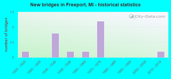
- New bridges - historical statistics
- 11920-1929
- 41940-1949
- 11950-1959
- 11960-1969
- 61970-1979
- 12010-2019


- Bridge Condition - Deck
- 22.2%Very good
- 22.2%Good
- 33.3%Satisfactory
- 11.1%Fair
- 11.1%Poor

- Bridge Condition - Superstructure
- 11.1%Very good
- 55.6%Good
- 11.1%Satisfactory
- 11.1%Serious
- 11.1%Imminent failure

- Bridge Condition - Substructure
- 33.3%Good
- 33.3%Satisfactory
- 33.3%Serious

- Bridge Condition - Channel
- 35.7%Very good
- 7.1%Good
- 35.7%Satisfactory
- 21.4%Fair

- Bridge Condition - Culverts
- 20.0%Very good
- 20.0%Good
- 40.0%Satisfactory
- 20.0%Fair
Find on map >> Show street view
Structure Number: 529, Location: 6.2 MI W OF WOODLAND (Lat: 42.726569, Lng: -85.255461), Route carried "on" structure: State highway 43, Year Built: 1956, Status: Open, Structure Length: 4.11m (13.48ft), Average Daily Traffic: 1,700 (year 2013), Truck Traffic: 8%, Average Future Daily Traffic: 3,163 (year 2018), Design Load: HS 20, Features Intersected: COLDWATER RIVER
Minimum Vertical Clearance: 30.48m (100.00ft), Kilometerpoint: 4.450, Lanes on structure: 2, Base Highway Network: Yes (Inventory Route: 98, Subroute: 3), Owner: State Highway Agency, Approaching Roadway Width: 11.2m (36.7ft), Skew: 2 degrees, Material/Design: Prestressed concrete, Design/Construction: Box Beam or Girders - Multiple, Number Of Spans In Main Unit: 3, Length of Maximum Span: 13.7m (44.9ft), Curb or Sidewalk Widths: Left: 0.3m (1.0ft), Right: 0.3m (1.0ft), Curb-To-Curb Width: 9.1m (29.9ft), Out-to-Out Width: 11.2m (36.7ft)
Condition: Deck: Satisfactory, Superstructure: Serious, Substructure: Serious, Channel: Fair, Operating Rating: 70.3 metric tons, Method Used To Determine Operating Rating: Load Factor (LF) rating reported by rating factor (RF) method using MS18 loading, Inventory Rating: 42.1 metric tons, Method Used To Determine Inventory Rating: Load Factor (LF) rating reported by rating factor (RF) method using MS18 loading, Structural Evaluation: High priority of corrective action, Deck Geometry: Somewhat better than minimum adequacy, Waterway Adequacy: Equal to present desirable criteria, Approach Roadway Alignment: Better than present minimum criteria, Length Of Structure Improvement: 4.12m (13.52ft), Designated Inspection Frequency: Every 12 months, Inspection Date: May 2021, Bridge Improvement Cost: $101,000, Roadway Improvement Cost: $5,000, Total Project Cost: $60,000, Deck Structure Type: Concrete Cast-file-Place, Wearing Surface/Protective System: Wearing Surface: Bituminous
Find on map >> Show street view
Structure Number: 555, Location: 0.20 MI E OF BARBER RD (Lat: 42.755536, Lng: -85.263475), Route carried "on" structure: County highway , Year Built: 1949, Status: Open, Structure Length: 2.47m (8.10ft), Average Daily Traffic: 889 (year 2015), Average Future Daily Traffic: 934 (year 2035), Design Load: HS 20+Mod, Features Intersected: N BRANCH THORNAPPLE, Facility Carried by Structure: BROWN ROAD
Minimum Vertical Clearance: 30.48m (100.00ft), Kilometerpoint: 3.777, Lanes on structure: 2, Owner: County Highway Agency, Approaching Roadway Width: 8.1m (26.6ft), Material/Design: Steel continuous, Design/Construction: Stringer/Multi-beam, Number Of Spans In Main Unit: 3, Length of Maximum Span: 8.2m (26.9ft), Curb or Sidewalk Widths: Left: 0.8m (2.6ft), Right: 0.8m (2.6ft), Curb-To-Curb Width: 7.3m (24.0ft), Out-to-Out Width: 9.0m (29.5ft)
Condition: Deck: Satisfactory, Superstructure: Good, Substructure: Serious, Channel: Satisfactory, Operating Rating: 49.9 metric tons, Method Used To Determine Operating Rating: Load Factor (LF) rating reported by rating factor (RF) method using MS18 loading, Inventory Rating: 29.8 metric tons, Method Used To Determine Inventory Rating: Load Factor (LF) rating reported by rating factor (RF) method using MS18 loading, Structural Evaluation: High priority of corrective action, Deck Geometry: Meets minimum limits, Waterway Adequacy: Better than present minimum criteria, Approach Roadway Alignment: Equal to present minimum criteria, Length Of Structure Improvement: 2.84m (9.32ft), Designated Inspection Frequency: Every 12 months, Inspection Date: July 2021, Bridge Improvement Cost: $320,000, Roadway Improvement Cost: $60,000, Total Project Cost: $380,000, Deck Structure Type: Concrete Cast-file-Place, Wearing Surface/Protective System: Wearing Surface: Epoxy Overlay
Find on map >> Show street view
Structure Number: 575, Location: IN FREEPORT (Lat: 42.769017, Lng: -85.309625), Route carried "on" structure: City street , Year Built: 1977, Status: Open, Structure Length: 2.34m (7.68ft), Average Daily Traffic: 99 (year 2004), Truck Traffic: 3%, Average Future Daily Traffic: 162 (year 2024), Design Load: HS 20+Mod, Features Intersected: COLDWATER RIVER, Facility Carried by Structure: EAST STREET
Minimum Vertical Clearance: 30.48m (100.00ft), Kilometerpoint: 4.679, Lanes on structure: 2, Owner: City or Municipal Highway Agency, Approaching Roadway Width: 9.1m (29.9ft), Material/Design: Prestressed concrete, Design/Construction: Box Beam or Girders - Multiple, Number Of Spans In Main Unit: 2, Length of Maximum Span: 11.5m (37.7ft), Curb-To-Curb Width: 8.8m (28.9ft), Out-to-Out Width: 9.2m (30.2ft)
Condition: Deck: Satisfactory, Superstructure: Good, Substructure: Satisfactory, Channel: Fair, Operating Rating: 54.5 metric tons, Method Used To Determine Operating Rating: Field evaluation and documented engineering judgment, Inventory Rating: 32.7 metric tons, Method Used To Determine Inventory Rating: Field evaluation and documented engineering judgment, Structural Evaluation: Equal to present minimum criteria, Deck Geometry: Better than present minimum criteria, Waterway Adequacy: Equal to present desirable criteria, Approach Roadway Alignment: Equal to present desirable criteria, Designated Inspection Frequency: Every 24 months, Inspection Date: April 2021, Wearing Surface/Protective System: Wearing Surface: Bituminous
Find on map >> Show street view
Structure Number: 4037, Location: 7.3 MI W VILL LAKE ODESSA (Lat: 42.785867, Lng: -85.291231), Route carried "on" structure: ServiceCounty highway 3403, Year Built: 2018, Status: Open, Structure Length: 1.44m (4.72ft), Average Daily Traffic: 2,430 (year 2017), Truck Traffic: 6%, Average Future Daily Traffic: 2,965 (year 2037), Design Load: Greater than HL93, Features Intersected: DUCK CREEK, Facility Carried by Structure: HASTINGS ROAD
Minimum Vertical Clearance: 30.48m (100.00ft), Kilometerpoint: 1.782, Lanes on structure: 2, Owner: County Highway Agency, Approaching Roadway Width: 11.6m (38.1ft), Skew: 3 degrees, Material/Design: Concrete, Design/Construction: Culvert, Number Of Spans In Main Unit: 1, Length of Maximum Span: 13.4m (44.0ft), Curb-To-Curb Width: 11.6m (38.1ft), Out-to-Out Width: 12.6m (41.3ft)
Condition: Channel: Very good, Culverts: Very good, Operating Rating: 63.2 metric tons, Method Used To Determine Operating Rating: Load and Resistance Factor Rating (LRFR) rating reported by rating factor(RF) method using HL-93 loadings, Inventory Rating: 48.9 metric tons, Method Used To Determine Inventory Rating: Load and Resistance Factor Rating (LRFR) rating reported by rating factor(RF) method using HL-93 loadings, Structural Evaluation: Equal to present desirable criteria, Deck Geometry: Somewhat better than minimum adequacy, Waterway Adequacy: Equal to present desirable criteria, Approach Roadway Alignment: Equal to present minimum criteria, Designated Inspection Frequency: Every 24 months, Inspection Date: October 2021, Wearing Surface/Protective System: Wearing Surface: Bituminous
Find on map >> Show street view
Structure Number: 4057, Location: 1.25 MI W 3.5 MI S CLARKS (Lat: 42.783678, Lng: -85.271450), Route carried "on" structure: ServiceCounty highway , Year Built: 1970, Status: Closed, Structure Length: 0.85m (2.79ft), Average Daily Traffic: 40 (year 2008), Truck Traffic: 10%, Average Future Daily Traffic: 47 (year 2028), Design Load: HS 20+Mod, Features Intersected: DUCK CREEK, Facility Carried by Structure: BELL ROAD
Minimum Vertical Clearance: 30.48m (100.00ft), Kilometerpoint: 1.547, Lanes on structure: 2, Owner: County Highway Agency, Approaching Roadway Width: 5.8m (19.0ft), Material/Design: Steel, Design/Construction: Stringer/Multi-beam, Number Of Spans In Main Unit: 1, Length of Maximum Span: 7.9m (25.9ft), Curb-To-Curb Width: 6.1m (20.0ft), Out-to-Out Width: 6.2m (20.3ft)
Condition: Deck: Poor, Superstructure: Imminent failure, Substructure: Serious, Channel: Fair, Operating Rating: 5.8 metric tons, Method Used To Determine Operating Rating: Load Factor (LF) rating reported by rating factor (RF) method using MS18 loading, Inventory Rating: 3.6 metric tons, Method Used To Determine Inventory Rating: Load Factor (LF) rating reported by rating factor (RF) method using MS18 loading, Deck Geometry: Somewhat better than minimum adequacy, Waterway Adequacy: Better than present minimum criteria, Approach Roadway Alignment: Equal to present minimum criteria, Bridge Posting: Required (Relationship of Operating Rating to Maximum Legal Load: > 39.9% below), Length Of Structure Improvement: 0.85m (2.79ft), Designated Inspection Frequency: Every 24 months, Inspection Date: October 2021, Bridge Improvement Cost: $29,000, Roadway Improvement Cost: $3,000, Total Project Cost: $34,000, Deck Structure Type: Corrugated Steel, Wearing Surface/Protective System: Wearing Surface: Bituminous
Find on map >> Show street view
Structure Number: 493, Location: 1.3 MI W OF IONIA COL (Lat: 42.798614, Lng: -85.335319), Route carried "on" structure: State highway 50, Year Built: 1940, Status: Open, Structure Length: 1.37m (4.49ft), Average Daily Traffic: 3,652 (year 2007), Truck Traffic: 10%, Average Future Daily Traffic: 4,304 (year 2018), Design Load: H 20, Features Intersected: TYLER CREEK
Minimum Vertical Clearance: 30.48m (100.00ft), Kilometerpoint: 11.618, Lanes on structure: 2, Base Highway Network: Yes (Inventory Route: 40, Subroute: 3), Owner: State Highway Agency, Approaching Roadway Width: 11.0m (36.1ft), Material/Design: Steel, Design/Construction: Stringer/Multi-beam, Number Of Spans In Main Unit: 1, Length of Maximum Span: 13.7m (44.9ft), Curb or Sidewalk Widths: Left: 0.4m (1.3ft), Right: 0.4m (1.3ft), Curb-To-Curb Width: 10.7m (35.1ft), Out-to-Out Width: 12.3m (40.4ft)
Condition: Deck: Fair, Superstructure: Satisfactory, Substructure: Good, Channel: Satisfactory, Operating Rating: 53.1 metric tons, Method Used To Determine Operating Rating: Load Factor (LF) rating reported by rating factor (RF) method using MS18 loading, Inventory Rating: 31.8 metric tons, Method Used To Determine Inventory Rating: Load Factor (LF) rating reported by rating factor (RF) method using MS18 loading, Structural Evaluation: Equal to present minimum criteria, Deck Geometry: Somewhat better than minimum adequacy, Waterway Adequacy: Equal to present desirable criteria, Approach Roadway Alignment: Equal to present desirable criteria, Length Of Structure Improvement: 1.37m (4.49ft), Designated Inspection Frequency: Every 24 months, Inspection Date: July 2020, Bridge Improvement Cost: $46,000, Roadway Improvement Cost: $4,000, Total Project Cost: $41,000, Deck Structure Type: Concrete Cast-file-Place, Wearing Surface/Protective System: Wearing Surface: Bituminous
Find on map >> Show street view
Structure Number: 5008, Location: 0.55 MI E OF WINGEIER AVE (Lat: 42.784133, Lng: -85.337858), Route carried "on" structure: County highway , Year Built: 1976, Status: Open, Structure Length: 1.06m (3.48ft), Average Daily Traffic: 400 (year 2003), Average Future Daily Traffic: 680 (year 2023), Design Load: HS 20+Mod, Features Intersected: TYLER CREEK, Facility Carried by Structure: 100TH STREET
Minimum Vertical Clearance: 30.48m (100.00ft), Kilometerpoint: 15.202, Lanes on structure: 2, Owner: County Highway Agency, Approaching Roadway Width: 7.9m (25.9ft), Skew: 3 degrees, Material/Design: Steel, Design/Construction: Culvert, Number Of Spans In Main Unit: 2, Length of Maximum Span: 5.1m (16.7ft)
Condition: Channel: Very good, Culverts: Satisfactory, Operating Rating: 53.8 metric tons, Method Used To Determine Operating Rating: Load Factor (LF) rating reported by rating factor (RF) method using MS18 loading, Inventory Rating: 47.6 metric tons, Method Used To Determine Inventory Rating: Load Factor (LF) rating reported by rating factor (RF) method using MS18 loading, Structural Evaluation: Equal to present minimum criteria, Waterway Adequacy: Equal to present desirable criteria, Approach Roadway Alignment: Equal to present desirable criteria, Designated Inspection Frequency: Every 24 months, Inspection Date: November 2021
Find on map >> Show street view
Structure Number: 501, Location: 0.40 MI E OF WINGEIER AVE (Lat: 42.812983, Lng: -85.342633), Route carried "on" structure: County highway , Year Built: 1976, Status: Open, Structure Length: 1.00m (3.28ft), Average Daily Traffic: 896 (year 2005), Average Future Daily Traffic: 1,520 (year 2025), Design Load: HS 20+Mod, Features Intersected: PRATT LAKE DRAIN, Facility Carried by Structure: 84TH STREET
Minimum Vertical Clearance: 30.48m (100.00ft), Kilometerpoint: 36.125, Lanes on structure: 2, Owner: County Highway Agency, Approaching Roadway Width: 7.3m (24.0ft), Material/Design: Steel, Design/Construction: Culvert, Number Of Spans In Main Unit: 2, Length of Maximum Span: 4.8m (15.7ft)
Condition: Channel: Satisfactory, Culverts: Fair, Operating Rating: 84.9 metric tons, Method Used To Determine Operating Rating: Load Factor (LF) rating reported by rating factor (RF) method using MS18 loading, Inventory Rating: 81.6 metric tons, Method Used To Determine Inventory Rating: Load Factor (LF) rating reported by rating factor (RF) method using MS18 loading, Structural Evaluation: Somewhat better than minimum adequacy, Waterway Adequacy: Equal to present desirable criteria, Approach Roadway Alignment: Equal to present desirable criteria, Designated Inspection Frequency: Every 24 months, Inspection Date: November 2021
Find on map >> Show street view
Structure Number: 5011, Location: 0.15 MI E OF PRATT LAKE (Lat: 42.813139, Lng: -85.327464), Route carried "on" structure: County highway , Year Built: 1927, Status: Open, Structure Length: 0.73m (2.40ft), Average Daily Traffic: 688 (year 2005), Average Future Daily Traffic: 1,170 (year 2025), Design Load: HS 20+Mod, Features Intersected: TYLER CREEK, Facility Carried by Structure: 84TH STREET
Minimum Vertical Clearance: 30.48m (100.00ft), Kilometerpoint: 37.365, Lanes on structure: 2, Owner: County Highway Agency, Approaching Roadway Width: 7.3m (24.0ft), Material/Design: Concrete, Design/Construction: Slab, Number Of Spans In Main Unit: 1, Length of Maximum Span: 6.4m (21.0ft), Curb-To-Curb Width: 6.4m (21.0ft), Out-to-Out Width: 7.2m (23.6ft)
Condition: Deck: Very good, Superstructure: Good, Substructure: Good, Channel: Very good, Operating Rating: 41.2 metric tons, Method Used To Determine Operating Rating: Load Factor (LF), Inventory Rating: 24.7 metric tons, Method Used To Determine Inventory Rating: Load Factor (LF), Structural Evaluation: Equal to present minimum criteria, Deck Geometry: High priority of corrective action, Waterway Adequacy: Equal to present desirable criteria, Approach Roadway Alignment: Equal to present desirable criteria, Designated Inspection Frequency: Every 24 months, Inspection Date: November 2021, Deck Structure Type: Concrete Cast-file-Place, Wearing Surface/Protective System: Wearing Surface: Bituminous
Find on map >> Show street view
Structure Number: 5081, Location: 0.10 MI N OF 108TH ST (Lat: 42.771333, Lng: -85.323250), Route carried "on" structure: County highway 4197, Year Built: 1948, Status: Open, Structure Length: 1.28m (4.20ft), Average Daily Traffic: 1,024 (year 2003), Average Future Daily Traffic: 1,740 (year 2023), Design Load: HS 20+Mod, Features Intersected: COLDWATER RIVER, Facility Carried by Structure: FREEPORT AVE
Minimum Vertical Clearance: 30.48m (100.00ft), Kilometerpoint: 0.177, Lanes on structure: 2, Owner: County Highway Agency, Approaching Roadway Width: 7.3m (24.0ft), Material/Design: Steel, Design/Construction: Stringer/Multi-beam, Number Of Spans In Main Unit: 1, Length of Maximum Span: 12.2m (40.0ft), Curb-To-Curb Width: 8.5m (27.9ft), Out-to-Out Width: 9.6m (31.5ft)
Condition: Deck: Good, Superstructure: Good, Substructure: Satisfactory, Channel: Very good, Operating Rating: 40.9 metric tons, Method Used To Determine Operating Rating: Load Factor (LF), Inventory Rating: 24.5 metric tons, Method Used To Determine Inventory Rating: Load Factor (LF), Structural Evaluation: Equal to present minimum criteria, Deck Geometry: Somewhat better than minimum adequacy, Waterway Adequacy: Equal to present desirable criteria, Approach Roadway Alignment: Equal to present minimum criteria, Designated Inspection Frequency: Every 24 months, Inspection Date: November 2021, Deck Structure Type: Concrete Cast-file-Place, Wearing Surface/Protective System: Wearing Surface: Bituminous
Find on map >> Show street view
Structure Number: 5082, Location: 0.20 MI S OF 100TH ST (Lat: 42.781156, Lng: -85.319686), Route carried "on" structure: County highway 4197, Year Built: 1948, Status: Open, Structure Length: 0.97m (3.18ft), Average Daily Traffic: 1,024 (year 2003), Average Future Daily Traffic: 1,740 (year 2023), Design Load: HS 20+Mod, Features Intersected: DUCK CREEK, Facility Carried by Structure: FREEPORT AVE
Minimum Vertical Clearance: 30.48m (100.00ft), Kilometerpoint: 1.426, Lanes on structure: 2, Owner: County Highway Agency, Approaching Roadway Width: 7.3m (24.0ft), Material/Design: Steel, Design/Construction: Stringer/Multi-beam, Number Of Spans In Main Unit: 1, Length of Maximum Span: 9.1m (29.9ft), Curb-To-Curb Width: 8.5m (27.9ft), Out-to-Out Width: 9.4m (30.8ft)
Condition: Deck: Good, Superstructure: Good, Substructure: Good, Channel: Very good, Operating Rating: 43.5 metric tons, Method Used To Determine Operating Rating: Load Factor (LF), Inventory Rating: 26.0 metric tons, Method Used To Determine Inventory Rating: Load Factor (LF), Structural Evaluation: Equal to present minimum criteria, Deck Geometry: Somewhat better than minimum adequacy, Waterway Adequacy: Equal to present minimum criteria, Approach Roadway Alignment: Equal to present desirable criteria, Designated Inspection Frequency: Every 24 months, Inspection Date: November 2021, Deck Structure Type: Concrete Cast-file-Place, Wearing Surface/Protective System: Wearing Surface: Bituminous
Find on map >> Show street view
Structure Number: 5118, Location: 0.6 MI S OF 100 ST (Lat: 42.774872, Lng: -85.358903), Route carried "on" structure: County highway , Year Built: 1978, Status: Open, Structure Length: 3.04m (9.97ft), Average Daily Traffic: 1,291 (year 2003), Average Future Daily Traffic: 2,190 (year 2023), Design Load: HS 20+Mod, Features Intersected: COLDWATER RIVER, Facility Carried by Structure: BAKER AVE
Minimum Vertical Clearance: 30.48m (100.00ft), Kilometerpoint: 0.615, Lanes on structure: 2, Owner: County Highway Agency, Approaching Roadway Width: 6.7m (22.0ft), Material/Design: Prestressed concrete, Design/Construction: Box Beam or Girders - Multiple, Number Of Spans In Main Unit: 2, Length of Maximum Span: 15.2m (49.9ft), Curb-To-Curb Width: 9.8m (32.2ft), Out-to-Out Width: 10.1m (33.1ft)
Condition: Deck: Very good, Superstructure: Very good, Substructure: Satisfactory, Channel: Good, Operating Rating: 62.0 metric tons, Method Used To Determine Operating Rating: Load Factor (LF), Inventory Rating: 37.1 metric tons, Method Used To Determine Inventory Rating: Load Factor (LF), Structural Evaluation: Equal to present minimum criteria, Deck Geometry: Somewhat better than minimum adequacy, Waterway Adequacy: Equal to present desirable criteria, Approach Roadway Alignment: Equal to present desirable criteria, Designated Inspection Frequency: Every 24 months, Inspection Date: November 2021, Deck Structure Type: Concrete Precast Panels, Wearing Surface/Protective System: Wearing Surface: Bituminous
Find on map >> Show street view
Structure Number: 5122, Location: 0.15 MI S OF 100TH ST (Lat: 42.781569, Lng: -85.309869), Route carried "on" structure: County highway , Year Built: 1976, Status: Open, Structure Length: 0.91m (2.99ft), Average Daily Traffic: 87 (year 2003), Average Future Daily Traffic: 150 (year 2023), Design Load: HS 20+Mod, Features Intersected: DUCK CREEK, Facility Carried by Structure: MONTCALM AVE
Minimum Vertical Clearance: 30.48m (100.00ft), Kilometerpoint: 1.299, Lanes on structure: 2, Owner: County Highway Agency, Approaching Roadway Width: 9.1m (29.9ft), Material/Design: Steel, Design/Construction: Culvert, Number Of Spans In Main Unit: 2, Length of Maximum Span: 4.5m (14.8ft)
Condition: Channel: Satisfactory, Culverts: Good, Operating Rating: 40.2 metric tons, Method Used To Determine Operating Rating: Load Factor (LF) rating reported by rating factor (RF) method using MS18 loading, Inventory Rating: 33.4 metric tons, Method Used To Determine Inventory Rating: Load Factor (LF) rating reported by rating factor (RF) method using MS18 loading, Structural Evaluation: Better than present minimum criteria, Waterway Adequacy: Equal to present desirable criteria, Approach Roadway Alignment: Equal to present desirable criteria, Designated Inspection Frequency: Every 24 months, Inspection Date: November 2021
Find on map >> Show street view
Structure Number: 14386, Location: 0.25 MI N OF FREEPORT RD (Lat: 42.766100, Lng: -85.290958), Route carried "on" structure: County highway 840, Year Built: 1965, Year Reconstructed: 2020, Status: Open, Structure Length: 0.70m (2.30ft), Average Daily Traffic: 3,513 (year 2020), Truck Traffic: 4%, Average Future Daily Traffic: 4,040 (year 2040), Features Intersected: COLDWATER RIVER, Facility Carried by Structure: N BROADWAY RD
Minimum Vertical Clearance: 30.48m (100.00ft), Kilometerpoint: 13.545, Lanes on structure: 2, Base Highway Network: Yes (Inventory Route: 98, Subroute: 8), Owner: County Highway Agency, Approaching Roadway Width: 9.6m (31.5ft), Material/Design: Steel, Design/Construction: Culvert, Number Of Spans In Main Unit: 2, Length of Maximum Span: 4.9m (16.1ft)
Condition: Channel: Satisfactory, Culverts: Satisfactory, Operating Rating: 78.1 metric tons, Method Used To Determine Operating Rating: Load and Resistance Factor Rating (LRFR) rating reported by rating factor(RF) method using HL-93 loadings, Inventory Rating: 60.3 metric tons, Method Used To Determine Inventory Rating: Load and Resistance Factor Rating (LRFR) rating reported by rating factor(RF) method using HL-93 loadings, Structural Evaluation: Equal to present minimum criteria, Waterway Adequacy: Equal to present minimum criteria, Approach Roadway Alignment: Better than present minimum criteria, Designated Inspection Frequency: Every 24 months, Inspection Date: July 2021, Wearing Surface/Protective System: Wearing Surface: Bituminous