Bridge Statistics for Freeport, Florida (FL)
Condition, Traffic, Stress, Structural Evaluation, Project Costs
- National Bridge Inventory (NBI) Statistics
- 25Number of bridges
- 1,093ft / 333mTotal length
- 139,076Total average daily traffic
- 15,459Total average daily truck traffic
- 241,273Total future (year 2041) average daily traffic
- National Bridge Inventory (NBI) Registered Bridges for Freeport
- No street view available for this location
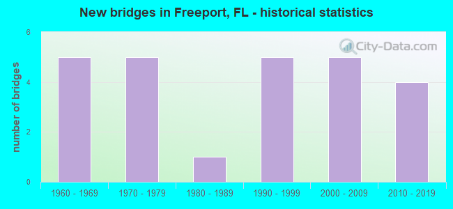
- New bridges - historical statistics
- 51960-1969
- 51970-1979
- 11980-1989
- 51990-1999
- 52000-2009
- 42010-2019


- Bridge Condition - Deck
- 54.5%Good
- 36.4%Satisfactory
- 9.1%Fair

- Bridge Condition - Superstructure
- 9.1%Very good
- 72.7%Good
- 13.6%Satisfactory
- 4.5%Fair

- Bridge Condition - Substructure
- 9.1%Very good
- 36.4%Good
- 40.9%Satisfactory
- 13.6%Fair

- Bridge Condition - Channel
- 4.3%Excellent
- 17.4%Very good
- 56.5%Good
- 17.4%Satisfactory
- 4.3%Poor
Find on map >> Show street view
Structure Number: 600033, Location: 0.1 Mi W of Bay Breeze Dr (Lat: 30.456942, Lng: -86.169736), Route carried "on" structure: County highway 83A, Year Built: 1964, Status: Open, Structure Length: 0.75m (2.46ft), Average Daily Traffic: 2,800 (year 2019), Truck Traffic: 10%, Average Future Daily Traffic: 4,858 (year 2041), Design Load: HS 20, Features Intersected: Bear Creek
Minimum Vertical Clearance: 30+ m (98+ ft), Kilometerpoint: 7.955, Lanes on structure: 2, Owner: County Highway Agency, Approaching Roadway Width: 7.3m (24.0ft), Material/Design: Concrete, Design/Construction: Culvert, Number Of Spans In Main Unit: 2, Length of Maximum Span: 3.7m (12.1ft)
Condition: Channel: Excellent, Culverts: Satisfactory, Operating Rating: 78.0 metric tons, Method Used To Determine Operating Rating: Load Factor (LF), Inventory Rating: 46.3 metric tons, Method Used To Determine Inventory Rating: Load Factor (LF), Structural Evaluation: Equal to present minimum criteria, Waterway Adequacy: Better than present minimum criteria, Approach Roadway Alignment: Equal to present desirable criteria, Designated Inspection Frequency: Every 24 months, Underwater Inspection Frequency: Every 24 months, Inspection Date: July 2020, Underwater Inspection Date: July 2020
Find on map >> Show street view
Structure Number: 600068, Location: 5.28 Mi West of SR 83 (Lat: 30.554969, Lng: -86.184672), Route carried "on" structure: County highway 282, Year Built: 1964, Status: Posted for load, Structure Length: 3.67m (12.04ft), Average Daily Traffic: 50 (year 2021), Average Future Daily Traffic: 87 (year 2042), Design Load: HS 20, Features Intersected: Little Alaqua Creek
Minimum Vertical Clearance: 30+ m (98+ ft), Kilometerpoint: 1.773, Lanes on structure: 2, Owner: County Highway Agency, Approaching Roadway Width: 6.1m (20.0ft), Material/Design: Concrete, Design/Construction: Slab, Number Of Spans In Main Unit: 4, Length of Maximum Span: 9.3m (30.5ft), Curb or Sidewalk Widths: Left: 0.2m (0.7ft), Right: 0.2m (0.7ft), Curb-To-Curb Width: 7.6m (24.9ft), Out-to-Out Width: 7.8m (25.6ft)
Condition: Deck: Good, Superstructure: Good, Substructure: Satisfactory, Channel: Satisfactory, Operating Rating: 29.0 metric tons, Method Used To Determine Operating Rating: Load Factor (LF), Inventory Rating: 17.2 metric tons, Method Used To Determine Inventory Rating: Load Factor (LF), Structural Evaluation: Somewhat better than minimum adequacy, Deck Geometry: Equal to present minimum criteria, Waterway Adequacy: Better than present minimum criteria, Approach Roadway Alignment: Equal to present desirable criteria, Bridge Posting: Required (Relationship of Operating Rating to Maximum Legal Load: 30.0 - 39.9% below), Designated Inspection Frequency: Every 24 months, Underwater Inspection Frequency: Every 24 months, Other Special Inspection Frequency: Every 12 months, Inspection Date: October 2020, Underwater Inspection Date: October 2020, Other Special Inspection Date: October 2021, Deck Structure Type: Concrete Cast-file-Place, Wearing Surface/Protective System: Wearing Surface: Bituminous
Find on map >> Show street view
Structure Number: 600081, Location: 4.92 Mi West of SR 83 (Lat: 30.556203, Lng: -86.179022), Route carried "on" structure: County highway 282, Year Built: 1964, Status: Posted for load-capacity, Structure Length: 9.12m (29.92ft), Average Daily Traffic: 500 (year 2020), Truck Traffic: 2%, Average Future Daily Traffic: 868 (year 2042), Features Intersected: Alaqua Creek
Minimum Vertical Clearance: 30+ m (98+ ft), Kilometerpoint: 2.309, Lanes on structure: 2, Owner: County Highway Agency, Approaching Roadway Width: 6.4m (21.0ft), Skew: 2 degrees, Material/Design: Concrete, Design/Construction: Slab, Number Of Spans In Main Unit: 10, Length of Maximum Span: 9.2m (30.2ft), Curb or Sidewalk Widths: Left: 0.2m (0.7ft), Right: 0.2m (0.7ft), Curb-To-Curb Width: 7.3m (24.0ft), Out-to-Out Width: 7.8m (25.6ft)
Condition: Deck: Satisfactory, Superstructure: Satisfactory, Substructure: Satisfactory, Channel: Poor, Operating Rating: 51.7 metric tons, Method Used To Determine Operating Rating: Load Factor (LF), Inventory Rating: 30.8 metric tons, Method Used To Determine Inventory Rating: Load Factor (LF), Structural Evaluation: Equal to present minimum criteria, Deck Geometry: Meets minimum limits, Waterway Adequacy: Better than present minimum criteria, Approach Roadway Alignment: Equal to present desirable criteria, Designated Inspection Frequency: Every 24 months, Underwater Inspection Frequency: Every 12 months, Other Special Inspection Frequency: Every 12 months, Inspection Date: April 2020, Underwater Inspection Date: April 2021, Other Special Inspection Date: April 2021, Deck Structure Type: Concrete Cast-file-Place, Wearing Surface/Protective System: Wearing Surface: Bituminous
Find on map >> Show street view
Structure Number: 600095, Location: 3.4 mi West Of US331,SR83 (Lat: 30.512036, Lng: -86.189239), Route carried "on" structure: State highway 20, Year Built: 1978, Status: Open, Structure Length: 7.01m (23.00ft), Average Daily Traffic: 8,500 (year 2020), Truck Traffic: 10%, Average Future Daily Traffic: 14,748 (year 2042), Design Load: HS 20, Features Intersected: Alaqua Slough
Minimum Vertical Clearance: 30+ m (98+ ft), Kilometerpoint: 21.509, Lanes on structure: 2, Base Highway Network: Yes, Owner: State Highway Agency, Approaching Roadway Width: 10.4m (34.1ft), Material/Design: Prestressed concrete continuous, Design/Construction: Stringer/Multi-beam, Number Of Spans In Main Unit: 5, Length of Maximum Span: 14.0m (45.9ft), Curb-To-Curb Width: 13.2m (43.3ft), Out-to-Out Width: 14.1m (46.3ft)
Condition: Deck: Satisfactory, Superstructure: Good, Substructure: Satisfactory, Channel: Satisfactory, Operating Rating: 77.1 metric tons, Method Used To Determine Operating Rating: Load Factor (LF), Inventory Rating: 46.3 metric tons, Method Used To Determine Inventory Rating: Load Factor (LF), Structural Evaluation: Equal to present minimum criteria, Deck Geometry: Somewhat better than minimum adequacy, Waterway Adequacy: Equal to present desirable criteria, Approach Roadway Alignment: Equal to present desirable criteria, Designated Inspection Frequency: Every 24 months, Underwater Inspection Frequency: Every 24 months, Inspection Date: October 2021, Underwater Inspection Date: October 2021, Deck Structure Type: Other
Find on map >> Show street view
Structure Number: 600096, Location: 3.2Mi West Of US331,SR83 (Lat: 30.512211, Lng: -86.186339), Route carried "on" structure: State highway 20, Year Built: 1978, Status: Open, Structure Length: 6.40m (21.00ft), Average Daily Traffic: 8,500 (year 2020), Truck Traffic: 10%, Average Future Daily Traffic: 14,748 (year 2042), Design Load: HS 20, Features Intersected: Big Alaqua Creek
Minimum Vertical Clearance: 30+ m (98+ ft), Kilometerpoint: 21.787, Lanes on structure: 2, Base Highway Network: Yes, Owner: State Highway Agency, Approaching Roadway Width: 10.4m (34.1ft), Material/Design: Prestressed concrete continuous, Design/Construction: Stringer/Multi-beam, Number Of Spans In Main Unit: 5, Length of Maximum Span: 12.8m (42.0ft), Curb-To-Curb Width: 13.2m (43.3ft), Out-to-Out Width: 14.1m (46.3ft)
Condition: Deck: Satisfactory, Superstructure: Good, Substructure: Satisfactory, Channel: Very good, Operating Rating: 77.1 metric tons, Method Used To Determine Operating Rating: Load Factor (LF), Inventory Rating: 46.3 metric tons, Method Used To Determine Inventory Rating: Load Factor (LF), Structural Evaluation: Equal to present minimum criteria, Deck Geometry: Somewhat better than minimum adequacy, Waterway Adequacy: Equal to present desirable criteria, Approach Roadway Alignment: Equal to present desirable criteria, Designated Inspection Frequency: Every 24 months, Underwater Inspection Frequency: Every 24 months, Inspection Date: October 2021, Underwater Inspection Date: October 2021, Deck Structure Type: Concrete Cast-file-Place
Find on map >> Show street view
Structure Number: 600104, Location: 1.6 mile west of US331 (Lat: 30.501833, Lng: -86.146167), Route carried "on" structure: State highway 20, Year Built: 1971, Status: Open, Structure Length: 1.12m (3.67ft), Average Daily Traffic: 8,500 (year 2020), Truck Traffic: 10%, Average Future Daily Traffic: 14,748 (year 2042), Design Load: HS 20, Features Intersected: Four Mile Creek
Minimum Vertical Clearance: 30+ m (98+ ft), Kilometerpoint: 25.890, Lanes on structure: 2, Base Highway Network: Yes, Owner: State Highway Agency, Approaching Roadway Width: 9.8m (32.2ft), Skew: 1 degrees, Material/Design: Concrete, Design/Construction: Culvert, Number Of Spans In Main Unit: 3, Length of Maximum Span: 3.4m (11.2ft)
Condition: Channel: Good, Culverts: Satisfactory, Operating Rating: 55.1 metric tons, Method Used To Determine Operating Rating: Load Factor (LF), Inventory Rating: 33.1 metric tons, Method Used To Determine Inventory Rating: Load Factor (LF), Structural Evaluation: Equal to present minimum criteria, Waterway Adequacy: Better than present minimum criteria, Approach Roadway Alignment: Equal to present desirable criteria, Designated Inspection Frequency: Every 24 months, Underwater Inspection Frequency: Every 24 months, Inspection Date: March 2021, Underwater Inspection Date: March 2021
Find on map >> Show street view
Structure Number: 600108, Location: 2.0mi. North of US98 (Lat: 30.404508, Lng: -86.166772), Route carried "on" structure: US 331, Year Built: 1991, Status: Open, Structure Length: 229.64m (753.41ft), Average Daily Traffic: 9,250 (year 2020), Truck Traffic: 11%, Average Future Daily Traffic: 16,049 (year 2042), Design Load: HS 20, Features Intersected: Choctawhatchee Bay
Minimum Vertical Clearance: 30+ m (98+ ft), Kilometerpoint: 3.396, Lanes on structure: 2, Base Highway Network: Yes, Owner: State Highway Agency, Approaching Roadway Width: 10.4m (34.1ft), Navigation Control: Yes ( Vertical Clearance: 19.8m (65.0ft), Horizontal Clearance: 45.7m (149.9ft)), Material/Design: Prestressed concrete continuous, Design/Construction: Stringer/Multi-beam, Number Of Spans In Main Unit: 45, Number Of Approach Spans: 35, Length of Maximum Span: 61.0m (200.1ft), Curb-To-Curb Width: 13.4m (44.0ft), Out-to-Out Width: 14.3m (46.9ft)
Condition: Deck: Good, Superstructure: Good, Substructure: Good, Channel: Very good, Operating Rating: 35.6 metric tons, Method Used To Determine Operating Rating: Load and Resistance Factor (LRFR), Inventory Rating: 32.7 metric tons, Method Used To Determine Inventory Rating: Load and Resistance Factor (LRFR), Structural Evaluation: Better than present minimum criteria, Deck Geometry: Superior to present desirable criteria, Waterway Adequacy: Equal to present desirable criteria, Approach Roadway Alignment: Equal to present desirable criteria, Designated Inspection Frequency: Every 24 months, Underwater Inspection Frequency: Every 24 months, Inspection Date: May 2021, Underwater Inspection Date: May 2021, Deck Structure Type: Concrete Cast-file-Place, Wearing Surface/Protective System: Deck Protection: Epoxy Coated Reinforcing
Find on map >> Show street view
Structure Number: 60011, Location: 4.3mi. North of US98 (Lat: 30.424967, Lng: -86.156986), Route carried "on" structure: US 331, Year Built: 1989, Status: Open, Structure Length: 9.14m (29.99ft), Average Daily Traffic: 9,250 (year 2020), Truck Traffic: 11%, Average Future Daily Traffic: 16,049 (year 2042), Design Load: HS 20, Features Intersected: Choctawhatchee Relief
Minimum Vertical Clearance: 30+ m (98+ ft), Kilometerpoint: 6.949, Lanes on structure: 2, Base Highway Network: Yes, Owner: State Highway Agency, Approaching Roadway Width: 9.8m (32.2ft), Material/Design: Concrete continuous, Design/Construction: Slab, Number Of Spans In Main Unit: 10, Length of Maximum Span: 9.1m (29.9ft), Curb-To-Curb Width: 13.4m (44.0ft), Out-to-Out Width: 14.4m (47.2ft)
Condition: Deck: Satisfactory, Superstructure: Good, Substructure: Satisfactory, Channel: Good, Operating Rating: 61.8 metric tons, Method Used To Determine Operating Rating: Load Factor (LF), Inventory Rating: 37.1 metric tons, Method Used To Determine Inventory Rating: Load Factor (LF), Structural Evaluation: Equal to present minimum criteria, Deck Geometry: Equal to present minimum criteria, Waterway Adequacy: Equal to present desirable criteria, Approach Roadway Alignment: Equal to present desirable criteria, Designated Inspection Frequency: Every 24 months, Underwater Inspection Frequency: Every 24 months, Inspection Date: October 2020, Underwater Inspection Date: October 2020, Deck Structure Type: Concrete Cast-file-Place
Find on map >> Show street view
Structure Number: 600113, Location: 1.5 Mi. South of SR20 (Lat: 30.469994, Lng: -86.129361), Route carried "on" structure: US 331, Year Built: 1996, Status: Open, Structure Length: 3.23m (10.60ft), Average Daily Traffic: 8,500 (year 2020), Truck Traffic: 12%, Average Future Daily Traffic: 14,748 (year 2042), Design Load: HS 20, Features Intersected: Ramsey Branch
Minimum Vertical Clearance: 30+ m (98+ ft), Kilometerpoint: 13.066, Lanes on structure: 2, Base Highway Network: Yes, Owner: State Highway Agency, Approaching Roadway Width: 10.4m (34.1ft), Material/Design: Concrete continuous, Design/Construction: Slab, Number Of Spans In Main Unit: 5, Length of Maximum Span: 6.5m (21.3ft), Curb-To-Curb Width: 13.4m (44.0ft), Out-to-Out Width: 14.4m (47.2ft)
Condition: Deck: Good, Superstructure: Good, Substructure: Satisfactory, Channel: Very good, Operating Rating: 75.3 metric tons, Method Used To Determine Operating Rating: Load Factor (LF), Inventory Rating: 45.4 metric tons, Method Used To Determine Inventory Rating: Load Factor (LF), Structural Evaluation: Equal to present minimum criteria, Deck Geometry: Superior to present desirable criteria, Waterway Adequacy: Equal to present desirable criteria, Approach Roadway Alignment: Equal to present desirable criteria, Designated Inspection Frequency: Every 24 months, Underwater Inspection Frequency: Every 24 months, Inspection Date: April 2020, Underwater Inspection Date: April 2020, Deck Structure Type: Concrete Cast-file-Place
Find on map >> Show street view
Structure Number: 600118, Location: 3.6 miles East of US331 (Lat: 30.478444, Lng: -86.065417), Route carried "on" structure: State highway 20, Year Built: 1995, Status: Open, Structure Length: 0.64m (2.10ft), Average Daily Traffic: 9,700 (year 2020), Truck Traffic: 14%, Average Future Daily Traffic: 16,830 (year 2042), Design Load: H 20, Features Intersected: Joyce Branch
Minimum Vertical Clearance: 30+ m (98+ ft), Kilometerpoint: 34.232, Lanes on structure: 2, Base Highway Network: Yes, Owner: State Highway Agency, Approaching Roadway Width: 10.4m (34.1ft), Material/Design: Concrete, Design/Construction: Culvert, Number Of Spans In Main Unit: 2, Length of Maximum Span: 3.0m (9.8ft)
Condition: Channel: Good, Culverts: Satisfactory, Operating Rating: 88.0 metric tons, Method Used To Determine Operating Rating: Load Factor (LF), Inventory Rating: 52.6 metric tons, Method Used To Determine Inventory Rating: Load Factor (LF), Structural Evaluation: Equal to present minimum criteria, Waterway Adequacy: Better than present minimum criteria, Approach Roadway Alignment: Equal to present desirable criteria, Designated Inspection Frequency: Every 24 months, Inspection Date: March 2021
Find on map >> Show street view
Structure Number: 60017, Location: 0.1Mi North of SR20 (Lat: 30.493017, Lng: -86.120539), Route carried "on" structure: US 331, Year Built: 2007, Status: Open, Structure Length: 5.64m (18.50ft), Average Daily Traffic: 15,000 (year 2020), Truck Traffic: 12%, Average Future Daily Traffic: 26,025 (year 2042), Design Load: HS 20, Features Intersected: Tributary #1
Minimum Vertical Clearance: 30+ m (98+ ft), Kilometerpoint: 15.738, Lanes on structure: 5, Base Highway Network: Yes, Owner: State Highway Agency, Approaching Roadway Width: 10.4m (34.1ft), Skew: 13 degrees, Material/Design: Prestressed concrete, Design/Construction: Stringer/Multi-beam, Number Of Spans In Main Unit: 3, Length of Maximum Span: 18.8m (61.7ft), Curb or Sidewalk Widths: Left: 1.8m (5.9ft), Right: 1.8m (5.9ft), Curb-To-Curb Width: 23.8m (78.1ft), Out-to-Out Width: 29.9m (98.1ft)
Condition: Deck: Good, Superstructure: Good, Substructure: Good, Channel: Good, Operating Rating: 77.1 metric tons, Method Used To Determine Operating Rating: Load Factor (LF), Inventory Rating: 46.3 metric tons, Method Used To Determine Inventory Rating: Load Factor (LF), Structural Evaluation: Better than present minimum criteria, Deck Geometry: Better than present minimum criteria, Waterway Adequacy: Equal to present desirable criteria, Approach Roadway Alignment: Equal to present desirable criteria, Designated Inspection Frequency: Every 24 months, Inspection Date: May 2021, Deck Structure Type: Concrete Cast-file-Place
Find on map >> Show street view
Structure Number: 600171, Location: 0.3Mi North of SR20 (Lat: 30.496567, Lng: -86.119286), Route carried "on" structure: US 331, Year Built: 2007, Status: Open, Structure Length: 6.10m (20.01ft), Average Daily Traffic: 7,500 (year 2020), Truck Traffic: 12%, Average Future Daily Traffic: 13,012 (year 2042), Design Load: HS 20, Features Intersected: Tributary #2
Minimum Vertical Clearance: 30+ m (98+ ft), Kilometerpoint: 16.143, Lanes on structure: 2, Base Highway Network: Yes, Owner: State Highway Agency, Approaching Roadway Width: 10.4m (34.1ft), Material/Design: Prestressed concrete, Design/Construction: Stringer/Multi-beam, Number Of Spans In Main Unit: 3, Length of Maximum Span: 20.3m (66.6ft), Curb-To-Curb Width: 13.4m (44.0ft), Out-to-Out Width: 14.4m (47.2ft)
Condition: Deck: Good, Superstructure: Good, Substructure: Good, Channel: Good, Operating Rating: 69.9 metric tons, Method Used To Determine Operating Rating: Load Factor (LF), Inventory Rating: 41.7 metric tons, Method Used To Determine Inventory Rating: Load Factor (LF), Structural Evaluation: Better than present minimum criteria, Deck Geometry: Superior to present desirable criteria, Waterway Adequacy: Equal to present desirable criteria, Approach Roadway Alignment: Equal to present desirable criteria, Designated Inspection Frequency: Every 24 months, Inspection Date: May 2021, Deck Structure Type: Concrete Cast-file-Place
Find on map >> Show street view
Structure Number: 600172, Location: 2.4Mi North of SR20 (Lat: 30.526472, Lng: -86.108222), Route carried "on" structure: US 331, Year Built: 2007, Status: Open, Structure Length: 12.19m (39.99ft), Average Daily Traffic: 7,500 (year 2020), Truck Traffic: 12%, Average Future Daily Traffic: 13,012 (year 2042), Design Load: HS 20, Features Intersected: Lafayette Creek
Minimum Vertical Clearance: 30+ m (98+ ft), Kilometerpoint: 19.607, Lanes on structure: 2, Base Highway Network: Yes, Owner: State Highway Agency, Approaching Roadway Width: 12.2m (40.0ft), Material/Design: Prestressed concrete, Design/Construction: Stringer/Multi-beam, Number Of Spans In Main Unit: 4, Length of Maximum Span: 32.7m (107.3ft), Curb-To-Curb Width: 13.4m (44.0ft), Out-to-Out Width: 14.4m (47.2ft)
Condition: Deck: Good, Superstructure: Good, Substructure: Very good, Channel: Very good, Operating Rating: 77.1 metric tons, Method Used To Determine Operating Rating: Load Factor (LF), Inventory Rating: 47.2 metric tons, Method Used To Determine Inventory Rating: Load Factor (LF), Structural Evaluation: Better than present minimum criteria, Deck Geometry: Superior to present desirable criteria, Waterway Adequacy: Superior to present desirable criteria, Approach Roadway Alignment: Equal to present desirable criteria, Designated Inspection Frequency: Every 24 months, Inspection Date: May 2021, Deck Structure Type: Concrete Cast-file-Place
Find on map >> Show street view
Structure Number: 60019, Location: 1.5Mi. South of SR20 (Lat: 30.469639, Lng: -86.129733), Route carried "on" structure: US 331, Year Built: 2015, Status: Open, Structure Length: 8.84m (29.00ft), Average Daily Traffic: 8,500 (year 2020), Truck Traffic: 12%, Average Future Daily Traffic: 14,748 (year 2042), Design Load: HL 93, Features Intersected: Ramsey Branch
Minimum Vertical Clearance: 30+ m (98+ ft), Kilometerpoint: 13.015, Lanes on structure: 2, Base Highway Network: Yes, Owner: State Highway Agency, Approaching Roadway Width: 10.4m (34.1ft), Skew: 6 degrees, Material/Design: Prestressed concrete, Design/Construction: Stringer/Multi-beam, Number Of Spans In Main Unit: 4, Length of Maximum Span: 22.1m (72.5ft), Curb-To-Curb Width: 12.2m (40.0ft), Out-to-Out Width: 14.4m (47.2ft)
Condition: Deck: Good, Superstructure: Very good, Substructure: Good, Channel: Good, Operating Rating: 51.6 metric tons, Method Used To Determine Operating Rating: Load and Resistance Factor (LRFR), Inventory Rating: 39.8 metric tons, Method Used To Determine Inventory Rating: Load and Resistance Factor (LRFR), Structural Evaluation: Better than present minimum criteria, Deck Geometry: Better than present minimum criteria, Approach Roadway Alignment: Equal to present desirable criteria, Designated Inspection Frequency: Every 24 months, Inspection Date: January 2021, Deck Structure Type: Concrete Cast-file-Place
Find on map >> Show street view
Structure Number: 600213, Location: 6.0 Miles North of SR20 (Lat: 30.578028, Lng: -86.108306), Route carried "on" structure: US 331, Year Built: 2012, Status: Open, Structure Length: 0.91m (2.99ft), Average Daily Traffic: 8,850 (year 2020), Truck Traffic: 12%, Average Future Daily Traffic: 15,355 (year 2042), Design Load: HL 93, Features Intersected: Wildlife Crossing
Minimum Vertical Clearance: 30+ m (98+ ft), Kilometerpoint: 9.622, Lanes on structure: 2, Base Highway Network: Yes, Owner: State Highway Agency, Approaching Roadway Width: 9.8m (32.2ft), Material/Design: Concrete, Design/Construction: Slab, Number Of Spans In Main Unit: 1, Length of Maximum Span: 9.1m (29.9ft), Curb-To-Curb Width: 10.4m (34.1ft), Out-to-Out Width: 13.1m (43.0ft)
Condition: Deck: Good, Superstructure: Good, Substructure: Good, Operating Rating: 54.5 metric tons, Method Used To Determine Operating Rating: Load and Resistance Factor (LRFR), Inventory Rating: 42.1 metric tons, Method Used To Determine Inventory Rating: Load and Resistance Factor (LRFR), Structural Evaluation: Better than present minimum criteria, Deck Geometry: Somewhat better than minimum adequacy, Approach Roadway Alignment: Equal to present desirable criteria, Designated Inspection Frequency: Every 24 months, Inspection Date: July 2020, Deck Structure Type: Concrete Cast-file-Place
Find on map >> Show street view
Structure Number: 600214, Location: 6.0 Mi North of SR20 (Lat: 30.577889, Lng: -86.108611), Route carried "on" structure: US 331, Year Built: 2012, Status: Open, Structure Length: 0.91m (2.99ft), Average Daily Traffic: 8,850 (year 2020), Truck Traffic: 12%, Average Future Daily Traffic: 15,355 (year 2042), Design Load: HL 93, Features Intersected: Wildlife Crossing
Minimum Vertical Clearance: 30+ m (98+ ft), Kilometerpoint: 9.622, Lanes on structure: 2, Base Highway Network: Yes, Owner: State Highway Agency, Approaching Roadway Width: 9.8m (32.2ft), Material/Design: Concrete, Design/Construction: Slab, Number Of Spans In Main Unit: 1, Length of Maximum Span: 9.1m (29.9ft), Curb-To-Curb Width: 12.2m (40.0ft), Out-to-Out Width: 13.1m (43.0ft)
Condition: Deck: Good, Superstructure: Good, Substructure: Good, Operating Rating: 54.5 metric tons, Method Used To Determine Operating Rating: Load and Resistance Factor (LRFR), Inventory Rating: 42.1 metric tons, Method Used To Determine Inventory Rating: Load and Resistance Factor (LRFR), Structural Evaluation: Better than present minimum criteria, Deck Geometry: Better than present minimum criteria, Approach Roadway Alignment: Equal to present desirable criteria, Designated Inspection Frequency: Every 24 months, Inspection Date: January 2021, Deck Structure Type: Concrete Cast-file-Place
Find on map >> Show street view
Structure Number: 60092, Location: 0.3mi West of US331 SR83 (Lat: 30.493253, Lng: -86.125842), Route carried "on" structure: State highway 20, Year Built: 1968, Status: Open, Structure Length: 7.62m (25.00ft), Average Daily Traffic: 13,100 (year 2020), Truck Traffic: 9%, Average Future Daily Traffic: 22,728 (year 2042), Design Load: HS 20, Features Intersected: Lafayette Creek
Minimum Vertical Clearance: 30+ m (98+ ft), Kilometerpoint: 28.020, Lanes on structure: 2, Base Highway Network: Yes, Owner: State Highway Agency, Approaching Roadway Width: 9.8m (32.2ft), Material/Design: Prestressed concrete, Design/Construction: Stringer/Multi-beam, Number Of Spans In Main Unit: 5, Length of Maximum Span: 15.2m (49.9ft), Curb-To-Curb Width: 13.3m (43.6ft), Out-to-Out Width: 14.1m (46.3ft)
Condition: Deck: Satisfactory, Superstructure: Good, Substructure: Satisfactory, Channel: Good, Operating Rating: 83.5 metric tons, Method Used To Determine Operating Rating: Load Factor (LF), Inventory Rating: 49.9 metric tons, Method Used To Determine Inventory Rating: Load Factor (LF), Structural Evaluation: Equal to present minimum criteria, Deck Geometry: Somewhat better than minimum adequacy, Waterway Adequacy: Equal to present desirable criteria, Approach Roadway Alignment: Equal to present desirable criteria, Designated Inspection Frequency: Every 24 months, Underwater Inspection Frequency: Every 24 months, Inspection Date: March 2020, Underwater Inspection Date: March 2020, Deck Structure Type: Concrete Cast-file-Place
Find on map >> Show street view
Structure Number: 604026, Location: 0.3 Mi South of Hwy 20 (Lat: 30.502361, Lng: -86.203306), Route carried "on" structure: County highway , Year Built: 1975, Year Reconstructed: 2006, Status: Posted for load, Structure Length: 1.55m (5.09ft), Average Daily Traffic: 75 (year 2021), Average Future Daily Traffic: 130 (year 2042), Design Load: HS 20, Features Intersected: West Bayou, Facility Carried by Structure: Whitfield Road
Minimum Vertical Clearance: 30+ m (98+ ft), Kilometerpoint: 0.921, Lanes on structure: 1, Owner: County Highway Agency, Approaching Roadway Width: 4.6m (15.1ft), Material/Design: Wood or Timber, Design/Construction: Stringer/Multi-beam, Number Of Spans In Main Unit: 5, Length of Maximum Span: 3.3m (10.8ft), Curb or Sidewalk Widths: Left: 0.1m (0.3ft), Right: 0.1m (0.3ft), Curb-To-Curb Width: 4.3m (14.1ft), Out-to-Out Width: 5.0m (16.4ft)
Condition: Deck: Satisfactory, Superstructure: Satisfactory, Substructure: Fair, Channel: Satisfactory, Operating Rating: 31.8 metric tons, Method Used To Determine Operating Rating: Allowable Stress (AS), Inventory Rating: 23.6 metric tons, Method Used To Determine Inventory Rating: Allowable Stress (AS), Structural Evaluation: Somewhat better than minimum adequacy, Deck Geometry: Equal to present minimum criteria, Waterway Adequacy: Better than present minimum criteria, Approach Roadway Alignment: Equal to present minimum criteria, Bridge Posting: Required (Relationship of Operating Rating to Maximum Legal Load: 0.1 - 9.9% below), Designated Inspection Frequency: Every 24 months, Underwater Inspection Frequency: Every 24 months, Other Special Inspection Frequency: Every 12 months, Inspection Date: January 2022, Underwater Inspection Date: January 2022, Other Special Inspection Date: January 2022, Deck Structure Type: Wood or Timber, Wearing Surface/Protective System: Wearing Surface: Wood or Timber
Find on map >> Show street view
Structure Number: 604121, Location: 0.4Mi W of E Bay Loop Rd (Lat: 30.496264, Lng: -86.145394), Route carried "on" structure: County highway , Year Built: 1994, Status: Posted for load, Structure Length: 2.23m (7.32ft), Average Daily Traffic: 101 (year 2021), Truck Traffic: 5%, Average Future Daily Traffic: 175 (year 2042), Features Intersected: Four Mile Creek, Facility Carried by Structure: Four Mile Road
Minimum Vertical Clearance: 30+ m (98+ ft), Kilometerpoint: 0.620, Lanes on structure: 2, Owner: County Highway Agency, Approaching Roadway Width: 5.5m (18.0ft), Material/Design: Wood or Timber, Design/Construction: Stringer/Multi-beam, Number Of Spans In Main Unit: 6, Length of Maximum Span: 4.0m (13.1ft), Curb or Sidewalk Widths: Left: 0.2m (0.7ft), Right: 0.2m (0.7ft), Curb-To-Curb Width: 6.7m (22.0ft), Out-to-Out Width: 7.3m (24.0ft)
Condition: Deck: Fair, Superstructure: Satisfactory, Substructure: Fair, Channel: Good, Operating Rating: 20.0 metric tons, Method Used To Determine Operating Rating: Allowable Stress (AS), Inventory Rating: 14.5 metric tons, Method Used To Determine Inventory Rating: Allowable Stress (AS), Structural Evaluation: Meets minimum limits, Deck Geometry: Meets minimum limits, Waterway Adequacy: Better than present minimum criteria, Approach Roadway Alignment: Equal to present minimum criteria, Bridge Posting: Required (Relationship of Operating Rating to Maximum Legal Load: 30.0 - 39.9% below), Designated Inspection Frequency: Every 24 months, Underwater Inspection Frequency: Every 24 months, Other Special Inspection Frequency: Every 12 months, Inspection Date: August 2020, Underwater Inspection Date: August 2020, Other Special Inspection Date: August 2021, Deck Structure Type: Wood or Timber, Wearing Surface/Protective System: Wearing Surface: Wood or Timber
Find on map >> Show street view
Structure Number: 604133, Location: 1.18 Mi S of US 331 (Lat: 30.470119, Lng: -86.125628), Route carried "on" structure: County highway , Year Built: 1997, Status: Open, Structure Length: 3.02m (9.91ft), Average Daily Traffic: 150 (year 2021), Truck Traffic: 1%, Average Future Daily Traffic: 260 (year 2042), Design Load: HS 20, Features Intersected: Ramsey Branch, Facility Carried by Structure: Old Jolly Bay Road
Minimum Vertical Clearance: 30+ m (98+ ft), Kilometerpoint: 0.581, Lanes on structure: 2, Owner: County Highway Agency, Approaching Roadway Width: 6.1m (20.0ft), Material/Design: Prestressed concrete, Design/Construction: Slab, Number Of Spans In Main Unit: 3, Length of Maximum Span: 10.1m (33.1ft), Curb-To-Curb Width: 7.7m (25.3ft), Out-to-Out Width: 8.3m (27.2ft)
Condition: Deck: Fair, Superstructure: Fair, Substructure: Satisfactory, Channel: Good, Operating Rating: 68.0 metric tons, Method Used To Determine Operating Rating: Load Factor (LF), Inventory Rating: 40.8 metric tons, Method Used To Determine Inventory Rating: Load Factor (LF), Structural Evaluation: Somewhat better than minimum adequacy, Deck Geometry: Somewhat better than minimum adequacy, Waterway Adequacy: Better than present minimum criteria, Approach Roadway Alignment: Equal to present minimum criteria, Designated Inspection Frequency: Every 24 months, Inspection Date: April 2021, Deck Structure Type: Concrete Precast Panels, Wearing Surface/Protective System: Wearing Surface: Bituminous
Find on map >> Show street view
Structure Number: 604194, Location: 0.1 Mi South of SR 20 (Lat: 30.501944, Lng: -86.150000), Route carried "on" structure: County highway , Year Built: 2005, Status: Open, Structure Length: 1.04m (3.41ft), Average Daily Traffic: 400 (year 2021), Truck Traffic: 1%, Average Future Daily Traffic: 694 (year 2042), Design Load: HS 20, Features Intersected: Four Mile Creek, Facility Carried by Structure: Four Mile Road
Minimum Vertical Clearance: 30+ m (98+ ft), Kilometerpoint: 1.759, Lanes on structure: 2, Owner: County Highway Agency, Approaching Roadway Width: 7.3m (24.0ft), Material/Design: Concrete, Design/Construction: Channel Beam, Number Of Spans In Main Unit: 1, Length of Maximum Span: 10.4m (34.1ft), Curb-To-Curb Width: 8.6m (28.2ft), Out-to-Out Width: 9.5m (31.2ft)
Condition: Deck: Satisfactory, Superstructure: Good, Substructure: Good, Channel: Good, Operating Rating: 74.9 metric tons, Method Used To Determine Operating Rating: Load Factor (LF), Inventory Rating: 44.9 metric tons, Method Used To Determine Inventory Rating: Load Factor (LF), Structural Evaluation: Better than present minimum criteria, Deck Geometry: Equal to present minimum criteria, Waterway Adequacy: Better than present minimum criteria, Approach Roadway Alignment: Equal to present desirable criteria, Designated Inspection Frequency: Every 24 months, Inspection Date: Febuary 2021, Deck Structure Type: Concrete Precast Panels
Find on map >> Show street view
Structure Number: 604217, Location: 0.54 MI S of CR 20 (Lat: 30.491667, Lng: -86.140278), Route carried "on" structure: County highway 83A, Year Built: 2010, Status: Open, Structure Length: 4.88m (16.01ft), Average Daily Traffic: 2,400 (year 2020), Truck Traffic: 11%, Average Future Daily Traffic: 4,164 (year 2042), Design Load: HS 20, Features Intersected: Fourmile Creek
Minimum Vertical Clearance: 30+ m (98+ ft), Kilometerpoint: 12.929, Lanes on structure: 2, Owner: County Highway Agency, Approaching Roadway Width: 7.3m (24.0ft), Material/Design: Concrete, Design/Construction: Channel Beam, Number Of Spans In Main Unit: 4, Length of Maximum Span: 12.2m (40.0ft), Curb-To-Curb Width: 8.5m (27.9ft), Out-to-Out Width: 8.5m (27.9ft)
Condition: Deck: Good, Superstructure: Good, Substructure: Good, Channel: Good, Inventory Rating: 58.1 metric tons, Method Used To Determine Inventory Rating: Load Factor (LF), Structural Evaluation: Better than present minimum criteria, Deck Geometry: Meets minimum limits, Waterway Adequacy: Equal to present minimum criteria, Approach Roadway Alignment: Equal to present desirable criteria, Designated Inspection Frequency: Every 24 months, Underwater Inspection Frequency: Every 24 months, Inspection Date: Febuary 2022, Underwater Inspection Date: Febuary 2022, Deck Structure Type: Other
Find on map >> Show street view
Structure Number: 604316, Location: 1.8MI N of Joe Dugger Rd (Lat: 30.518889, Lng: -86.048333), Route carried "on" structure: County highway , Year Built: 1978, Status: Posted for load-capacity, Structure Length: 1.55m (5.09ft), Average Daily Traffic: 50 (year 2020), Average Future Daily Traffic: 87 (year 2042), Features Intersected: Lafayette Creek, Facility Carried by Structure: J W Hollington Rd
Minimum Vertical Clearance: 30+ m (98+ ft), Kilometerpoint: 5.816, Lanes on structure: 1, Owner: County Highway Agency, Approaching Roadway Width: 3.7m (12.1ft), Material/Design: Wood or Timber, Design/Construction: Stringer/Multi-beam, Number Of Spans In Main Unit: 4, Length of Maximum Span: 4.1m (13.5ft), Curb or Sidewalk Widths: Left: 0.2m (0.7ft), Right: 0.2m (0.7ft), Curb-To-Curb Width: 4.6m (15.1ft), Out-to-Out Width: 4.9m (16.1ft)
Condition: Deck: Satisfactory, Superstructure: Good, Substructure: Fair, Channel: Satisfactory, Operating Rating: 29.0 metric tons, Method Used To Determine Operating Rating: Allowable Stress (AS), Inventory Rating: 21.9 metric tons, Method Used To Determine Inventory Rating: Allowable Stress (AS), Structural Evaluation: Somewhat better than minimum adequacy, Deck Geometry: Better than present minimum criteria, Waterway Adequacy: Better than present minimum criteria, Approach Roadway Alignment: Somewhat better than minimum adequacy, Designated Inspection Frequency: Every 24 months, Underwater Inspection Frequency: Every 24 months, Inspection Date: Febuary 2022, Underwater Inspection Date: Febuary 2022, Deck Structure Type: Wood or Timber, Wearing Surface/Protective System: Wearing Surface: Wood or Timber, Deck Protection: Other
Find on map >> Show street view
Structure Number: 605229, Location: 0.6Mi South of SR 20 (Lat: 30.499778, Lng: -86.159417), Route carried "on" structure: City street , Year Built: 2005, Status: Open, Structure Length: 2.08m (6.82ft), Average Daily Traffic: 1,000 (year 2021), Truck Traffic: 1%, Average Future Daily Traffic: 1,740 (year 2042), Design Load: HS 20, Features Intersected: Unnamed Branch, Facility Carried by Structure: Great Hammock Bend
Minimum Vertical Clearance: 30+ m (98+ ft), Kilometerpoint: 0.000, Lanes on structure: 2, Owner: City or Municipal Highway Agency, Approaching Roadway Width: 8.1m (26.6ft), Material/Design: Steel, Design/Construction: Truss - Thru, Number Of Spans In Main Unit: 1, Length of Maximum Span: 20.8m (68.2ft), Curb or Sidewalk Widths: Left: 0.0m, Right: 2.4m (7.9ft), Curb-To-Curb Width: 8.6m (28.2ft), Out-to-Out Width: 11.6m (38.1ft)
Condition: Deck: Good, Superstructure: Very good, Substructure: Very good, Channel: Good, Operating Rating: 33.6 metric tons, Method Used To Determine Operating Rating: Load and Resistance Factor (LRFR), Inventory Rating: 25.9 metric tons, Method Used To Determine Inventory Rating: Load and Resistance Factor (LRFR), Structural Evaluation: Equal to present minimum criteria, Deck Geometry: Somewhat better than minimum adequacy, Waterway Adequacy: Equal to present desirable criteria, Approach Roadway Alignment: Equal to present desirable criteria, Designated Inspection Frequency: Every 24 months, Critical Feature Inspection Frequency: Every 24 months, Inspection Date: Febuary 2021, Critical Feature Inspection Date: Febuary 2021, Deck Structure Type: Concrete Cast-file-Place
Find on map >> Show street view
Structure Number: AFFLFTFA12244, Location: 2 MILES WEST OF S.R. 20 (Lat: 30.517292, Lng: -86.236103), Route carried "on" structure: Federal lands road 218, Year Built: 1965, Status: Open, Structure Length: 3.26m (10.70ft), Average Daily Traffic: 50 (year 2021), Average Future Daily Traffic: 55 (year 2041), Features Intersected: BASIN CREEK
Minimum Vertical Clearance: 30+ m (98+ ft), Kilometerpoint: 0.000, Lanes on structure: 1, Owner: Air Force, Approaching Roadway Width: 6.2m (20.3ft), Material/Design: Concrete, Design/Construction: Slab, Number Of Spans In Main Unit: 3, Length of Maximum Span: 11.0m (36.1ft), Curb-To-Curb Width: 5.7m (18.7ft), Out-to-Out Width: 6.2m (20.3ft)
Condition: Deck: Good, Superstructure: Good, Substructure: Satisfactory, Channel: Good, Operating Rating: 36.3 metric tons, Method Used To Determine Operating Rating: Load Factor (LF), Inventory Rating: 21.8 metric tons, Method Used To Determine Inventory Rating: Load Factor (LF), Structural Evaluation: Equal to present minimum criteria, Deck Geometry: Meets minimum limits, Waterway Adequacy: Equal to present minimum criteria, Approach Roadway Alignment: Equal to present desirable criteria, Designated Inspection Frequency: Every 24 months, Inspection Date: October 2021, Deck Structure Type: Concrete Precast Panels, Wearing Surface/Protective System: Wearing Surface: Bituminous