Bridge Statistics for Fredonia, Alabama (AL)
Condition, Traffic, Stress, Structural Evaluation, Project Costs
- National Bridge Inventory (NBI) Statistics
- 31Number of bridges
- 266ft / 80.7mTotal length
- $24,309,000Total costs
- 35,125Total average daily traffic
- 3,161Total average daily truck traffic
- 48,775Total future (year 2026) average daily traffic
- National Bridge Inventory (NBI) Registered Bridges for Fredonia
- No street view available for this location
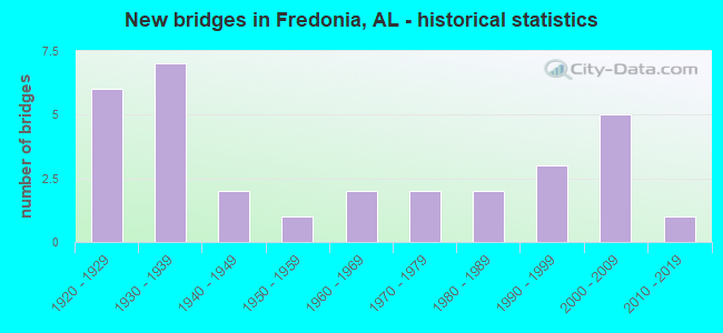
- New bridges - historical statistics
- 61920-1929
- 71930-1939
- 21940-1949
- 11950-1959
- 21960-1969
- 21970-1979
- 21980-1989
- 31990-1999
- 52000-2009
- 12010-2019

- Reconstructed bridges - Historical Statistics
- 11950-1959
- 01960-1969
- 01970-1979
- 11980-1989


- Bridge Condition - Deck
- 8.7%Excellent
- 13.0%Very good
- 30.4%Good
- 21.7%Satisfactory
- 26.1%Fair

- Bridge Condition - Superstructure
- 4.3%Excellent
- 13.0%Very good
- 30.4%Good
- 30.4%Satisfactory
- 17.4%Fair
- 4.3%Critical

- Bridge Condition - Substructure
- 8.7%Excellent
- 21.7%Good
- 43.5%Satisfactory
- 21.7%Fair
- 4.3%Poor

- Bridge Condition - Channel
- 3.3%Excellent
- 20.0%Very good
- 16.7%Good
- 46.7%Satisfactory
- 13.3%Fair

- Bridge Condition - Culverts
- 25.0%Excellent
- 25.0%Very good
- 12.5%Satisfactory
- 37.5%Fair
Find on map >> Show street view
Structure Number: 126, Location: 1 MI SOUTH PEAVY (Lat: 33.129600, Lng: -85.461200), Route carried "on" structure: County highway , Year Built: 1920, Status: Closed, Structure Length: 2.01m (6.59ft), Average Daily Traffic: 80 (year 1991), Average Future Daily Traffic: 126 (year 2026), Design Load: H 10, Features Intersected: HIGHPINE CREEK, Facility Carried by Structure: CO RD #861
Minimum Vertical Clearance: 30+ m (98+ ft), Kilometerpoint: 0.000, Lanes on structure: 1, Owner: County Highway Agency, Approaching Roadway Width: 5.5m (18.0ft), Material/Design: Steel, Design/Construction: Truss - Thru, Number Of Spans In Main Unit: 1, Length of Maximum Span: 20.1m (65.9ft), Curb-To-Curb Width: 3.7m (12.1ft), Out-to-Out Width: 3.7m (12.1ft)
Condition: Deck: Fair, Superstructure: Critical, Substructure: Fair, Channel: Satisfactory, Deck Geometry: Meets minimum limits, Waterway Adequacy: Equal to present minimum criteria, Approach Roadway Alignment: Equal to present minimum criteria, Bridge Posting: Required (Relationship of Operating Rating to Maximum Legal Load: > 39.9% below), Length Of Structure Improvement: 2.76m (9.06ft), Designated Inspection Frequency: Every 24 months, Critical Feature Inspection Frequency: Every 3 months, Other Special Inspection Frequency: Every 6 months, Inspection Date: January 2008, Critical Feature Inspection Date: January 2008, Other Special Inspection Date: Febuary 2008, Bridge Improvement Cost: $228,000, Roadway Improvement Cost: $23,000, Total Project Cost: $251,000 ( Estimate for 2022), Deck Structure Type: Wood or Timber, Wearing Surface/Protective System: Wearing Surface: Wood or Timber
Find on map >> Show street view
Structure Number: 188, Location: 4.8 MI N JCT US72 * SR65 (Lat: 34.730869, Lng: -86.287642), Route carried "on" structure: State highway 65, Year Built: 1922, Status: Open, Structure Length: 0.73m (2.40ft), Average Daily Traffic: 934 (year 2020), Truck Traffic: 2%, Average Future Daily Traffic: 1,308 (year 2040), Design Load: H 10, Features Intersected: BRANCH
Minimum Vertical Clearance: 30+ m (98+ ft), Kilometerpoint: 7.652, Lanes on structure: 2, Owner: State Highway Agency, Approaching Roadway Width: 6.1m (20.0ft), Material/Design: Concrete continuous, Design/Construction: Slab, Number Of Spans In Main Unit: 2, Length of Maximum Span: 3.0m (9.8ft), Curb-To-Curb Width: 6.1m (20.0ft), Out-to-Out Width: 7.9m (25.9ft)
Condition: Deck: Satisfactory, Superstructure: Satisfactory, Substructure: Satisfactory, Channel: Satisfactory, Operating Rating: 32.7 metric tons, Method Used To Determine Operating Rating: Field evaluation and documented engineering judgment, Inventory Rating: 23.6 metric tons, Method Used To Determine Inventory Rating: Field evaluation and documented engineering judgment, Structural Evaluation: Equal to present minimum criteria, Deck Geometry: High priority of corrective action, Waterway Adequacy: Equal to present minimum criteria, Approach Roadway Alignment: Equal to present desirable criteria, Length Of Structure Improvement: 1.38m (4.53ft), Designated Inspection Frequency: Every 24 months, Inspection Date: August 2021, Bridge Improvement Cost: $245,000, Roadway Improvement Cost: $25,000, Total Project Cost: $270,000 ( Estimate for 2022), Deck Structure Type: Concrete Cast-file-Place, Wearing Surface/Protective System: Wearing Surface: Bituminous
Find on map >> Show street view
Structure Number: 189, Location: 10.7 MI N JCT US72 * SR65 (Lat: 34.790636, Lng: -86.252139), Route carried "on" structure: State highway 65, Year Built: 1922, Status: Open, Structure Length: 0.67m (2.20ft), Average Daily Traffic: 714 (year 2020), Truck Traffic: 2%, Average Future Daily Traffic: 999 (year 2040), Design Load: H 10, Features Intersected: BRANCH
Minimum Vertical Clearance: 30+ m (98+ ft), Kilometerpoint: 17.263, Lanes on structure: 2, Owner: State Highway Agency, Approaching Roadway Width: 6.7m (22.0ft), Material/Design: Concrete continuous, Design/Construction: Slab, Number Of Spans In Main Unit: 2, Length of Maximum Span: 3.0m (9.8ft), Curb-To-Curb Width: 6.7m (22.0ft), Out-to-Out Width: 6.7m (22.0ft)
Condition: Deck: Good, Superstructure: Good, Substructure: Satisfactory, Channel: Satisfactory, Operating Rating: 32.7 metric tons, Method Used To Determine Operating Rating: Field evaluation and documented engineering judgment, Inventory Rating: 23.6 metric tons, Method Used To Determine Inventory Rating: Field evaluation and documented engineering judgment, Structural Evaluation: Equal to present minimum criteria, Deck Geometry: Meets minimum limits, Waterway Adequacy: Equal to present minimum criteria, Approach Roadway Alignment: Equal to present desirable criteria, Length Of Structure Improvement: 1.30m (4.27ft), Designated Inspection Frequency: Every 24 months, Inspection Date: January 2022, Bridge Improvement Cost: $196,000, Roadway Improvement Cost: $20,000, Total Project Cost: $216,000 ( Estimate for 2022), Deck Structure Type: Concrete Cast-file-Place, Wearing Surface/Protective System: Wearing Surface: Bituminous
Find on map >> Show street view
Structure Number: 243, Location: 0.2 MI N JCT SR 35 (Lat: 34.675472, Lng: -86.187525), Route carried "on" structure: County highway 119, Year Built: 1924, Status: Open, Structure Length: 0.67m (2.20ft), Average Daily Traffic: 170 (year 1989), Truck Traffic: 5%, Average Future Daily Traffic: 235 (year 2040), Design Load: H 10, Features Intersected: BRANCH
Minimum Vertical Clearance: 30+ m (98+ ft), Kilometerpoint: 0.010, Lanes on structure: 2, Owner: County Highway Agency, Approaching Roadway Width: 7.3m (24.0ft), Skew: 1 degrees, Material/Design: Concrete, Design/Construction: Slab, Number Of Spans In Main Unit: 2, Length of Maximum Span: 4.3m (14.1ft), Curb-To-Curb Width: 6.3m (20.7ft), Out-to-Out Width: 6.7m (22.0ft)
Condition: Deck: Good, Superstructure: Good, Substructure: Fair, Channel: Satisfactory, Operating Rating: 43.5 metric tons, Method Used To Determine Operating Rating: Field evaluation and documented engineering judgment, Inventory Rating: 32.7 metric tons, Method Used To Determine Inventory Rating: Field evaluation and documented engineering judgment, Structural Evaluation: Somewhat better than minimum adequacy, Deck Geometry: Meets minimum limits, Waterway Adequacy: Better than present minimum criteria, Approach Roadway Alignment: Better than present minimum criteria, Length Of Structure Improvement: 1.30m (4.27ft), Designated Inspection Frequency: Every 24 months, Inspection Date: January 2022, Bridge Improvement Cost: $196,000, Roadway Improvement Cost: $20,000, Total Project Cost: $216,000 ( Estimate for 2022), Deck Structure Type: Concrete Cast-file-Place, Wearing Surface/Protective System: Wearing Surface: Other
Find on map >> Show street view
Structure Number: 244, Location: 2.1 MI E US 78 (Lat: 33.853506, Lng: -87.448244), Route carried "on" structure: State highway 124, Year Built: 1924, Status: Open, Structure Length: 0.91m (2.99ft), Average Daily Traffic: 435 (year 2020), Truck Traffic: 17%, Average Future Daily Traffic: 370 (year 2041), Design Load: H 15, Features Intersected: Downey Branch
Minimum Vertical Clearance: 30+ m (98+ ft), Kilometerpoint: 3.384, Lanes on structure: 2, Owner: State Highway Agency, Approaching Roadway Width: 8.5m (27.9ft), Material/Design: Concrete, Design/Construction: Tee Beam, Number Of Spans In Main Unit: 1, Length of Maximum Span: 9.1m (29.9ft), Curb-To-Curb Width: 6.4m (21.0ft), Out-to-Out Width: 8.2m (26.9ft)
Condition: Deck: Satisfactory, Superstructure: Fair, Substructure: Satisfactory, Channel: Satisfactory, Operating Rating: 64.0 metric tons, Method Used To Determine Operating Rating: Load Factor (LF), Inventory Rating: 38.3 metric tons, Method Used To Determine Inventory Rating: Load Factor (LF), Structural Evaluation: Somewhat better than minimum adequacy, Deck Geometry: High priority of corrective action, Waterway Adequacy: Better than present minimum criteria, Approach Roadway Alignment: Equal to present minimum criteria, Length Of Structure Improvement: 1.59m (5.22ft), Designated Inspection Frequency: Every 24 months, Inspection Date: Febuary 2021, Bridge Improvement Cost: $294,000, Roadway Improvement Cost: $29,000, Total Project Cost: $323,000 ( Estimate for 2022), Deck Structure Type: Concrete Cast-file-Place, Wearing Surface/Protective System: Wearing Surface: Bituminous
Find on map >> Show street view
Structure Number: 245, Location: Hurricane Creek (Lat: 33.853336, Lng: -87.448178), Route carried "on" structure: State highway 124, Year Built: 1924, Status: Open, Structure Length: 3.72m (12.20ft), Average Daily Traffic: 460 (year 2020), Truck Traffic: 17%, Average Future Daily Traffic: 586 (year 2041), Design Load: H 15, Features Intersected: Huricane Creek
Minimum Vertical Clearance: 30+ m (98+ ft), Kilometerpoint: 4.062, Lanes on structure: 2, Owner: State Highway Agency, Approaching Roadway Width: 6.4m (21.0ft), Material/Design: Concrete, Design/Construction: Tee Beam, Number Of Spans In Main Unit: 4, Length of Maximum Span: 9.1m (29.9ft), Curb-To-Curb Width: 6.4m (21.0ft), Out-to-Out Width: 6.5m (21.3ft)
Condition: Deck: Fair, Superstructure: Fair, Substructure: Fair, Channel: Satisfactory, Operating Rating: 64.5 metric tons, Method Used To Determine Operating Rating: Load Factor (LF), Inventory Rating: 40.5 metric tons, Method Used To Determine Inventory Rating: Load Factor (LF), Structural Evaluation: Somewhat better than minimum adequacy, Deck Geometry: High priority of corrective action, Waterway Adequacy: Better than present minimum criteria, Approach Roadway Alignment: Somewhat better than minimum adequacy, Length Of Structure Improvement: 4.65m (15.26ft), Designated Inspection Frequency: Every 24 months, Inspection Date: Febuary 2021, Bridge Improvement Cost: $669,000, Roadway Improvement Cost: $67,000, Total Project Cost: $736,000 ( Estimate for 2022), Deck Structure Type: Concrete Cast-file-Place, Wearing Surface/Protective System: Wearing Surface: Bituminous
Find on map >> Show street view
Structure Number: 125, Location: 1 MILE EAST OF CONCORD (Lat: 33.456867, Lng: -87.019667), Route carried "on" structure: County highway 46, Year Built: 1935, Status: Open, Structure Length: 0.76m (2.49ft), Average Daily Traffic: 10,556 (year 2021), Truck Traffic: 15%, Average Future Daily Traffic: 14,750 (year 2041), Features Intersected: LICK CREEK TRIBUTARY, Facility Carried by Structure: WARRIOR RIVER ROAD
Minimum Vertical Clearance: 30+ m (98+ ft), Kilometerpoint: 0.010, Lanes on structure: 2, Owner: County Highway Agency, Approaching Roadway Width: 7.5m (24.6ft), Material/Design: Concrete, Design/Construction: Frame, Number Of Spans In Main Unit: 1, Length of Maximum Span: 6.2m (20.3ft), Curb or Sidewalk Widths: Left: 0.1m (0.3ft), Right: 0.1m (0.3ft), Curb-To-Curb Width: 9.1m (29.9ft), Out-to-Out Width: 10.0m (32.8ft)
Condition: Deck: Satisfactory, Superstructure: Fair, Substructure: Satisfactory, Channel: Satisfactory, Operating Rating: 32.7 metric tons, Method Used To Determine Operating Rating: Field evaluation and documented engineering judgment, Inventory Rating: 23.6 metric tons, Method Used To Determine Inventory Rating: Field evaluation and documented engineering judgment, Structural Evaluation: Somewhat better than minimum adequacy, Deck Geometry: High priority of corrective action, Waterway Adequacy: Equal to present minimum criteria, Approach Roadway Alignment: Better than present minimum criteria, Length Of Structure Improvement: 1.41m (4.63ft), Designated Inspection Frequency: Every 24 months, Inspection Date: August 2021, Bridge Improvement Cost: $309,000, Roadway Improvement Cost: $31,000, Total Project Cost: $340,000 ( Estimate for 2022), Deck Structure Type: Concrete Cast-file-Place, Wearing Surface/Protective System: Wearing Surface: Bituminous
Find on map >> Show street view
Structure Number: 129, Location: 0.1 MI N JCT CO RD 015 (Lat: 34.896342, Lng: -86.731897), Route carried "on" structure: County highway 87, Year Built: 1935, Status: Open, Structure Length: 0.73m (2.40ft), Average Daily Traffic: 316 (year 1992), Truck Traffic: 1%, Average Future Daily Traffic: 465 (year 2040), Design Load: H 15, Features Intersected: ENNIS BRANCH, Facility Carried by Structure: BAITES RD
Minimum Vertical Clearance: 30+ m (98+ ft), Kilometerpoint: 0.010, Lanes on structure: 2, Owner: County Highway Agency, Approaching Roadway Width: 7.9m (25.9ft), Material/Design: Masonry, Design/Construction: Culvert, Number Of Spans In Main Unit: 2, Length of Maximum Span: 3.7m (12.1ft), Curb-To-Curb Width: 6.2m (20.3ft), Out-to-Out Width: 6.7m (22.0ft)
Condition: Channel: Fair, Culverts: Fair, Operating Rating: 32.7 metric tons, Method Used To Determine Operating Rating: Field evaluation and documented engineering judgment, Inventory Rating: 23.6 metric tons, Method Used To Determine Inventory Rating: Field evaluation and documented engineering judgment, Structural Evaluation: Somewhat better than minimum adequacy, Deck Geometry: Meets minimum limits, Waterway Adequacy: Somewhat better than minimum adequacy, Approach Roadway Alignment: Somewhat better than minimum adequacy, Length Of Structure Improvement: 1.38m (4.53ft), Designated Inspection Frequency: Every 24 months, Inspection Date: November 2020, Bridge Improvement Cost: $175,000, Roadway Improvement Cost: $18,000, Total Project Cost: $193,000 ( Estimate for 2022)
Find on map >> Show street view
Structure Number: 13, Location: 0.4 MI S CO RD 015 (Lat: 34.899383, Lng: -86.698753), Route carried "on" structure: County highway 94, Year Built: 1935, Status: Open, Structure Length: 0.73m (2.40ft), Average Daily Traffic: 239 (year 2001), Truck Traffic: 1%, Average Future Daily Traffic: 286 (year 2035), Design Load: H 15, Features Intersected: DRY BRANCH, Facility Carried by Structure: BO HOWARD RD
Minimum Vertical Clearance: 30+ m (98+ ft), Kilometerpoint: 0.010, Lanes on structure: 2, Owner: County Highway Agency, Approaching Roadway Width: 7.9m (25.9ft), Material/Design: Masonry, Design/Construction: Culvert, Number Of Spans In Main Unit: 2, Length of Maximum Span: 3.0m (9.8ft), Curb-To-Curb Width: 6.2m (20.3ft), Out-to-Out Width: 6.7m (22.0ft)
Condition: Channel: Fair, Culverts: Fair, Operating Rating: 32.7 metric tons, Method Used To Determine Operating Rating: Field evaluation and documented engineering judgment, Inventory Rating: 23.6 metric tons, Method Used To Determine Inventory Rating: Field evaluation and documented engineering judgment, Structural Evaluation: Somewhat better than minimum adequacy, Deck Geometry: Meets minimum limits, Waterway Adequacy: Somewhat better than minimum adequacy, Approach Roadway Alignment: Somewhat better than minimum adequacy, Length Of Structure Improvement: 1.38m (4.53ft), Designated Inspection Frequency: Every 24 months, Inspection Date: November 2020, Bridge Improvement Cost: $175,000, Roadway Improvement Cost: $18,000, Total Project Cost: $193,000 ( Estimate for 2022)
Find on map >> Show street view
Structure Number: 131, Location: AL 119 * LIL CAHABARIVER (Lat: 33.540000, Lng: -86.561667), Route carried "on" structure: State highway 119, Year Built: 1935, Status: Open, Structure Length: 1.46m (4.79ft), Average Daily Traffic: 7,650 (year 2021), Truck Traffic: 6%, Average Future Daily Traffic: 10,043 (year 2041), Design Load: H 15, Features Intersected: LITTLE CAHABA RIVER
Minimum Vertical Clearance: 30+ m (98+ ft), Kilometerpoint: 62.159, Lanes on structure: 2, Owner: State Highway Agency, Approaching Roadway Width: 8.5m (27.9ft), Material/Design: Concrete, Design/Construction: Slab, Number Of Spans In Main Unit: 2, Length of Maximum Span: 7.3m (24.0ft), Curb-To-Curb Width: 8.7m (28.5ft), Out-to-Out Width: 9.3m (30.5ft)
Condition: Deck: Satisfactory, Superstructure: Satisfactory, Substructure: Satisfactory, Channel: Satisfactory, Operating Rating: 43.5 metric tons, Method Used To Determine Operating Rating: Field evaluation and documented engineering judgment, Inventory Rating: 32.7 metric tons, Method Used To Determine Inventory Rating: Field evaluation and documented engineering judgment, Structural Evaluation: Equal to present minimum criteria, Deck Geometry: High priority of replacement, Waterway Adequacy: Somewhat better than minimum adequacy, Approach Roadway Alignment: Better than present minimum criteria, Length Of Structure Improvement: 2.14m (7.02ft), Designated Inspection Frequency: Every 24 months, Inspection Date: May 2021, Bridge Improvement Cost: $440,000, Roadway Improvement Cost: $44,000, Total Project Cost: $484,000 ( Estimate for 2022), Deck Structure Type: Concrete Cast-file-Place, Wearing Surface/Protective System: Wearing Surface: Bituminous
Find on map >> Show street view
Structure Number: 132, Location: 200 FT E HWY 79 PINSON (Lat: 33.695000, Lng: -86.688200), Route carried "on" structure: County highway 131, Year Built: 1935, Status: Open, Structure Length: 1.53m (5.02ft), Average Daily Traffic: 671 (year 2020), Truck Traffic: 1%, Average Future Daily Traffic: 930 (year 2040), Features Intersected: BEAVER CREEK(PINSON), Facility Carried by Structure: OLD BRADFORD RD
Minimum Vertical Clearance: 30+ m (98+ ft), Kilometerpoint: 0.010, Lanes on structure: 2, Owner: County Highway Agency, Approaching Roadway Width: 5.8m (19.0ft), Material/Design: Concrete, Design/Construction: Arch - Deck, Number Of Spans In Main Unit: 1, Length of Maximum Span: 15.3m (50.2ft), Curb-To-Curb Width: 6.1m (20.0ft), Out-to-Out Width: 6.6m (21.7ft)
Condition: Deck: Satisfactory, Superstructure: Satisfactory, Substructure: Satisfactory, Channel: Satisfactory, Operating Rating: 43.5 metric tons, Method Used To Determine Operating Rating: Field evaluation and documented engineering judgment, Inventory Rating: 32.7 metric tons, Method Used To Determine Inventory Rating: Field evaluation and documented engineering judgment, Structural Evaluation: Equal to present minimum criteria, Deck Geometry: High priority of corrective action, Waterway Adequacy: Equal to present minimum criteria, Approach Roadway Alignment: Better than present minimum criteria, Length Of Structure Improvement: 2.21m (7.25ft), Designated Inspection Frequency: Every 24 months, Inspection Date: December 2020, Bridge Improvement Cost: $318,000, Roadway Improvement Cost: $32,000, Total Project Cost: $350,000 ( Estimate for 2022)
Find on map >> Show street view
Structure Number: 139, Location: DOWNTOWN EVERGREEN (Lat: 31.434508, Lng: -86.954275), Route carried "on" structure: US 31, Year Built: 1936, Status: Open, Structure Length: 21.73m (71.29ft), Average Daily Traffic: 5,800 (year 2019), Truck Traffic: 10%, Average Future Daily Traffic: 8,700 (year 2039), Design Load: H 15, Features Intersected: CSX RR * CITY STREETS
Minimum Vertical Clearance: 30+ m (98+ ft), Kilometerpoint: 154.228, Lanes on structure: 2, Lanes under structure: 4, Owner: State Highway Agency, Approaching Roadway Width: 10.9m (35.8ft), Material/Design: Steel continuous, Design/Construction: Stringer/Multi-beam, Number Of Spans In Main Unit: 2, Number Of Approach Spans: 17, Length of Maximum Span: 20.4m (66.9ft), Curb or Sidewalk Widths: Left: 2.1m (6.9ft), Right: 0.0m, Curb-To-Curb Width: 10.9m (35.8ft), Out-to-Out Width: 14.1m (46.3ft)
Condition: Deck: Fair, Superstructure: Fair, Substructure: Fair, Operating Rating: 51.6 metric tons, Method Used To Determine Operating Rating: Load Factor (LF), Inventory Rating: 30.8 metric tons, Method Used To Determine Inventory Rating: Load Factor (LF), Structural Evaluation: Somewhat better than minimum adequacy, Deck Geometry: Meets minimum limits, Underclear: High priority of corrective action, Approach Roadway Alignment: Somewhat better than minimum adequacy, Length Of Structure Improvement: 21.73m (71.29ft), Designated Inspection Frequency: Every 24 months, Critical Feature Inspection Frequency: Every 24 months, Other Special Inspection Frequency: Every 24 months, Inspection Date: January 2021, Critical Feature Inspection Date: January 2021, Other Special Inspection Date: January 2021, Bridge Improvement Cost: $6,855,000, Roadway Improvement Cost: $686,000, Total Project Cost: $7,541,000 ( Estimate for 2022), Deck Structure Type: Concrete Cast-file-Place
Find on map >> Show street view
Structure Number: 241, Location: CEDAR SPRINGS DR. (Lat: 33.817050, Lng: -85.807803), Route carried "on" structure: County highway 72, Year Built: 1940, Status: Temporarily open, Structure Length: 1.83m (6.00ft), Average Daily Traffic: 1,461 (year 2009), Truck Traffic: 2%, Average Future Daily Traffic: 1,570 (year 2041), Features Intersected: TALLASEEHATCHEE CREEK, Facility Carried by Structure: 2 MI W J'VILLE
Minimum Vertical Clearance: 7.56m (24.80ft), Kilometerpoint: 0.010, Lanes on structure: 2, Owner: County Highway Agency, Approaching Roadway Width: 9.1m (29.9ft), Material/Design: Steel, Design/Construction: Stringer/Multi-beam, Number Of Spans In Main Unit: 2, Length of Maximum Span: 9.1m (29.9ft), Curb-To-Curb Width: 7.6m (24.9ft), Out-to-Out Width: 8.3m (27.2ft)
Condition: Deck: Fair, Superstructure: Satisfactory, Substructure: Fair, Channel: Fair, Operating Rating: 14.0 metric tons, Method Used To Determine Operating Rating: Load Factor (LF), Inventory Rating: 8.3 metric tons, Method Used To Determine Inventory Rating: Load Factor (LF), Structural Evaluation: High priority of replacement, Deck Geometry: Meets minimum limits, Waterway Adequacy: Better than present minimum criteria, Approach Roadway Alignment: Somewhat better than minimum adequacy, Length Of Structure Improvement: 2.54m (8.33ft), Designated Inspection Frequency: Every 24 months, Inspection Date: June 2021, Bridge Improvement Cost: $471,000, Roadway Improvement Cost: $47,000, Total Project Cost: $518,000 ( Estimate for 2022), Deck Structure Type: Concrete Cast-file-Place, Wearing Surface/Protective System: Wearing Surface: Bituminous
Find on map >> Show street view
Structure Number: 242, Location: 50TH ST * 15TH AVE NO (Lat: 33.566667, Lng: -86.750000), Route carried "on" structure: City street , Year Built: 1940, Status: Open, Structure Length: 1.04m (3.41ft), Average Daily Traffic: 1,000 (year 2018), Truck Traffic: 1%, Average Future Daily Traffic: 1,500 (year 2038), Design Load: H 15, Features Intersected: BRANCH, Facility Carried by Structure: 50TH ST
Minimum Vertical Clearance: 30+ m (98+ ft), Kilometerpoint: 0.599, Lanes on structure: 3, Owner: City or Municipal Highway Agency, Approaching Roadway Width: 13.0m (42.7ft), Skew: 1 degrees, Material/Design: Concrete, Design/Construction: Culvert, Number Of Spans In Main Unit: 2, Length of Maximum Span: 5.0m (16.4ft), Curb or Sidewalk Widths: Left: 1.2m (3.9ft), Right: 0.0m, Out-to-Out Width: 26.0m (85.3ft)
Condition: Channel: Fair, Culverts: Satisfactory, Operating Rating: 32.7 metric tons, Method Used To Determine Operating Rating: Field evaluation and documented engineering judgment, Inventory Rating: 23.6 metric tons, Method Used To Determine Inventory Rating: Field evaluation and documented engineering judgment, Structural Evaluation: Equal to present minimum criteria, Waterway Adequacy: Somewhat better than minimum adequacy, Approach Roadway Alignment: Equal to present minimum criteria, Length Of Structure Improvement: 1.71m (5.61ft), Designated Inspection Frequency: Every 24 months, Inspection Date: June 2020, Bridge Improvement Cost: $841,000, Roadway Improvement Cost: $84,000, Total Project Cost: $925,000 ( Estimate for 2022)
Find on map >> Show street view
Structure Number: 3918, Location: 2 MI. N.E. FIVE POINTS (Lat: 33.028886, Lng: -85.325381), Route carried "on" structure: County highway 260, Year Built: 1950, Status: Posted for load, Structure Length: 1.75m (5.74ft), Average Daily Traffic: 15 (year 1992), Average Future Daily Traffic: 30 (year 2034), Features Intersected: GAY CREEK
Minimum Vertical Clearance: 30+ m (98+ ft), Kilometerpoint: 0.010, Lanes on structure: 1, Owner: County Highway Agency, Approaching Roadway Width: 6.1m (20.0ft), Material/Design: Steel, Design/Construction: Stringer/Multi-beam, Number Of Spans In Main Unit: 1, Length of Maximum Span: 15.9m (52.2ft), Curb-To-Curb Width: 4.6m (15.1ft), Out-to-Out Width: 4.6m (15.1ft)
Condition: Deck: Good, Superstructure: Good, Substructure: Satisfactory, Channel: Satisfactory, Operating Rating: 31.8 metric tons, Method Used To Determine Operating Rating: Allowable Stress (AS), Inventory Rating: 19.6 metric tons, Method Used To Determine Inventory Rating: Allowable Stress (AS), Structural Evaluation: Somewhat better than minimum adequacy, Deck Geometry: Better than present minimum criteria, Waterway Adequacy: Somewhat better than minimum adequacy, Approach Roadway Alignment: Somewhat better than minimum adequacy, Bridge Posting: Required (Relationship of Operating Rating to Maximum Legal Load: 20.0 - 29.9% below), Length Of Structure Improvement: 2.46m (8.07ft), Designated Inspection Frequency: Every 24 months, Other Special Inspection Frequency: Every 12 months, Inspection Date: August 2020, Other Special Inspection Date: August 2021, Bridge Improvement Cost: $253,000, Roadway Improvement Cost: $25,000, Total Project Cost: $278,000 ( Estimate for 2022), Deck Structure Type: Concrete Cast-file-Place
Find on map >> Show street view
Structure Number: 5002, Location: 2 MI. N.W. DENSON (Lat: 32.951094, Lng: -85.324697), Route carried "on" structure: County highway 179, Year Built: 1935, Year Reconstructed: 1955, Status: Posted for load, Structure Length: 1.92m (6.30ft), Average Daily Traffic: 7 (year 2010), Average Future Daily Traffic: 10 (year 2034), Features Intersected: WELLS CREEK
Minimum Vertical Clearance: 30+ m (98+ ft), Kilometerpoint: 0.010, Lanes on structure: 1, Owner: County Highway Agency, Approaching Roadway Width: 6.1m (20.0ft), Material/Design: Steel, Design/Construction: Stringer/Multi-beam, Number Of Spans In Main Unit: 1, Number Of Approach Spans: 2, Length of Maximum Span: 8.2m (26.9ft), Curb or Sidewalk Widths: Left: 0.1m (0.3ft), Right: 0.1m (0.3ft), Curb-To-Curb Width: 4.8m (15.7ft), Out-to-Out Width: 4.8m (15.7ft)
Condition: Deck: Fair, Superstructure: Satisfactory, Substructure: Poor, Channel: Satisfactory, Operating Rating: 5.4 metric tons, Method Used To Determine Operating Rating: Allowable Stress (AS), Inventory Rating: 3.6 metric tons, Method Used To Determine Inventory Rating: Allowable Stress (AS), Structural Evaluation: High priority of replacement, Deck Geometry: Equal to present desirable criteria, Waterway Adequacy: Equal to present minimum criteria, Approach Roadway Alignment: Meets minimum limits, Bridge Posting: Required (Relationship of Operating Rating to Maximum Legal Load: > 39.9% below), Length Of Structure Improvement: 2.65m (8.69ft), Designated Inspection Frequency: Every 24 months, Other Special Inspection Frequency: Every 12 months, Inspection Date: August 2020, Other Special Inspection Date: August 2021, Bridge Improvement Cost: $273,000, Roadway Improvement Cost: $27,000, Total Project Cost: $300,000 ( Estimate for 2022), Deck Structure Type: Corrugated Steel, Wearing Surface/Protective System: Wearing Surface: Gravel
Find on map >> Show street view
Structure Number: 7809, Location: 1 MI. N.E. FREDONIA (Lat: 33.007750, Lng: -85.277642), Route carried "on" structure: County highway 263, Year Built: 1962, Status: Open, Structure Length: 1.46m (4.79ft), Average Daily Traffic: 199 (year 2014), Truck Traffic: 6%, Average Future Daily Traffic: 296 (year 2037), Design Load: HS 20, Features Intersected: VEASEY CREEK
Minimum Vertical Clearance: 30+ m (98+ ft), Kilometerpoint: 0.010, Lanes on structure: 2, Owner: County Highway Agency, Approaching Roadway Width: 8.5m (27.9ft), Material/Design: Concrete, Design/Construction: Culvert, Number Of Spans In Main Unit: 4, Length of Maximum Span: 3.7m (12.1ft)
Condition: Channel: Good, Culverts: Fair, Operating Rating: 66.9 metric tons, Method Used To Determine Operating Rating: Load Factor (LF), Inventory Rating: 40.1 metric tons, Method Used To Determine Inventory Rating: Load Factor (LF), Structural Evaluation: Somewhat better than minimum adequacy, Waterway Adequacy: Equal to present desirable criteria, Approach Roadway Alignment: Equal to present desirable criteria, Length Of Structure Improvement: 2.14m (7.02ft), Designated Inspection Frequency: Every 24 months, Inspection Date: Febuary 2022, Bridge Improvement Cost: $444,000, Roadway Improvement Cost: $44,000, Total Project Cost: $488,000 ( Estimate for 2022)
Find on map >> Show street view
Structure Number: 11016, Location: 3 MI. N. E. FREDONIA (Lat: 33.002583, Lng: -85.247981), Route carried "on" structure: County highway 1266, Year Built: 1973, Status: Open, Structure Length: 5.67m (18.60ft), Average Daily Traffic: 861 (year 2009), Truck Traffic: 8%, Average Future Daily Traffic: 1,279 (year 2035), Design Load: HS 20, Features Intersected: WEST POINT RESERVOIR
Minimum Vertical Clearance: 30+ m (98+ ft), Kilometerpoint: 0.010, Lanes on structure: 2, Owner: County Highway Agency, Approaching Roadway Width: 9.1m (29.9ft), Material/Design: Concrete, Design/Construction: Tee Beam, Number Of Spans In Main Unit: 5, Length of Maximum Span: 11.3m (37.1ft), Curb-To-Curb Width: 8.2m (26.9ft), Out-to-Out Width: 9.4m (30.8ft)
Condition: Deck: Good, Superstructure: Good, Substructure: Good, Channel: Very good, Operating Rating: 43.5 metric tons, Method Used To Determine Operating Rating: Field evaluation and documented engineering judgment, Inventory Rating: 32.7 metric tons, Method Used To Determine Inventory Rating: Field evaluation and documented engineering judgment, Structural Evaluation: Better than present minimum criteria, Deck Geometry: Somewhat better than minimum adequacy, Waterway Adequacy: Superior to present desirable criteria, Approach Roadway Alignment: Equal to present desirable criteria, Length Of Structure Improvement: 6.70m (21.98ft), Designated Inspection Frequency: Every 24 months, Underwater Inspection Frequency: Every 48 months, Inspection Date: November 2021, Underwater Inspection Date: July 2020, Bridge Improvement Cost: $1,379,000, Roadway Improvement Cost: $138,000, Total Project Cost: $1,517,000 ( Estimate for 2022), Deck Structure Type: Concrete Cast-file-Place
Find on map >> Show street view
Structure Number: 11017, Location: 8 MI. N.E. FREDONIA (Lat: 33.032994, Lng: -85.248694), Route carried "on" structure: County highway 1266, Year Built: 1973, Status: Open, Structure Length: 6.31m (20.70ft), Average Daily Traffic: 938 (year 2009), Truck Traffic: 8%, Average Future Daily Traffic: 1,393 (year 2035), Design Load: HS 20, Features Intersected: WEST POINT RESERVOIR
Minimum Vertical Clearance: 30+ m (98+ ft), Kilometerpoint: 0.010, Lanes on structure: 2, Owner: County Highway Agency, Approaching Roadway Width: 9.1m (29.9ft), Material/Design: Concrete, Design/Construction: Tee Beam, Number Of Spans In Main Unit: 5, Length of Maximum Span: 12.8m (42.0ft), Curb or Sidewalk Widths: Left: 0.1m (0.3ft), Right: 0.1m (0.3ft), Curb-To-Curb Width: 8.2m (26.9ft), Out-to-Out Width: 9.3m (30.5ft)
Condition: Deck: Good, Superstructure: Good, Substructure: Satisfactory, Channel: Good, Operating Rating: 43.5 metric tons, Method Used To Determine Operating Rating: Field evaluation and documented engineering judgment, Inventory Rating: 32.7 metric tons, Method Used To Determine Inventory Rating: Field evaluation and documented engineering judgment, Structural Evaluation: Equal to present minimum criteria, Deck Geometry: Somewhat better than minimum adequacy, Waterway Adequacy: Superior to present desirable criteria, Approach Roadway Alignment: Equal to present desirable criteria, Length Of Structure Improvement: 7.35m (24.11ft), Designated Inspection Frequency: Every 24 months, Underwater Inspection Frequency: Every 48 months, Inspection Date: November 2021, Underwater Inspection Date: July 2020, Bridge Improvement Cost: $1,512,000, Roadway Improvement Cost: $151,000, Total Project Cost: $1,663,000 ( Estimate for 2022), Deck Structure Type: Concrete Cast-file-Place
Find on map >> Show street view
Structure Number: 13823, Location: 2 MI. S. E. FREDONIA (Lat: 32.970528, Lng: -85.268756), Route carried "on" structure: County highway 1289, Year Built: 1964, Year Reconstructed: 1986, Status: Open, Structure Length: 1.55m (5.09ft), Average Daily Traffic: 1,180 (year 2012), Truck Traffic: 8%, Average Future Daily Traffic: 1,753 (year 2037), Design Load: HS 20, Features Intersected: HARDLEY CREEK
Minimum Vertical Clearance: 30+ m (98+ ft), Kilometerpoint: 0.010, Lanes on structure: 2, Owner: County Highway Agency, Approaching Roadway Width: 11.0m (36.1ft), Material/Design: Steel, Design/Construction: Stringer/Multi-beam, Number Of Spans In Main Unit: 2, Length of Maximum Span: 7.6m (24.9ft), Curb or Sidewalk Widths: Left: 0.2m (0.7ft), Right: 0.2m (0.7ft), Curb-To-Curb Width: 8.5m (27.9ft), Out-to-Out Width: 9.1m (29.9ft)
Condition: Deck: Good, Superstructure: Good, Substructure: Good, Channel: Good, Operating Rating: 88.9 metric tons, Method Used To Determine Operating Rating: Load Factor (LF), Inventory Rating: 55.4 metric tons, Method Used To Determine Inventory Rating: Load Factor (LF), Structural Evaluation: Better than present minimum criteria, Deck Geometry: Somewhat better than minimum adequacy, Waterway Adequacy: Superior to present desirable criteria, Approach Roadway Alignment: Equal to present desirable criteria, Length Of Structure Improvement: 2.23m (7.32ft), Designated Inspection Frequency: Every 24 months, Inspection Date: Febuary 2022, Bridge Improvement Cost: $444,000, Roadway Improvement Cost: $44,000, Total Project Cost: $488,000 ( Estimate for 2022), Deck Structure Type: Concrete Cast-file-Place
Find on map >> Show street view
Structure Number: 14, Location: 0.5 MI N US 78 (Lat: 33.690528, Lng: -86.995872), Route carried "on" structure: County highway 146, Year Built: 1986, Status: Open, Structure Length: 1.92m (6.30ft), Average Daily Traffic: 25 (year 2018), Average Future Daily Traffic: 50 (year 2040), Design Load: HS 20, Features Intersected: CANE CREEK, Facility Carried by Structure: LITTLETON ROAD
Minimum Vertical Clearance: 30+ m (98+ ft), Kilometerpoint: 0.000, Lanes on structure: 2, Owner: City or Municipal Highway Agency, Approaching Roadway Width: 6.1m (20.0ft), Material/Design: Concrete, Design/Construction: Box Beam or Girders - Multiple, Number Of Spans In Main Unit: 1, Length of Maximum Span: 18.6m (61.0ft), Curb or Sidewalk Widths: Left: 0.2m (0.7ft), Right: 0.2m (0.7ft), Curb-To-Curb Width: 6.9m (22.6ft), Out-to-Out Width: 7.5m (24.6ft)
Condition: Deck: Good, Superstructure: Good, Substructure: Satisfactory, Channel: Satisfactory, Operating Rating: 73.7 metric tons, Method Used To Determine Operating Rating: Load Factor (LF), Inventory Rating: 44.1 metric tons, Method Used To Determine Inventory Rating: Load Factor (LF), Structural Evaluation: Equal to present minimum criteria, Deck Geometry: Somewhat better than minimum adequacy, Waterway Adequacy: Equal to present minimum criteria, Approach Roadway Alignment: Equal to present minimum criteria, Length Of Structure Improvement: 2.65m (8.69ft), Designated Inspection Frequency: Every 24 months, Inspection Date: April 2020, Bridge Improvement Cost: $436,000, Roadway Improvement Cost: $44,000, Total Project Cost: $480,000 ( Estimate for 2022), Deck Structure Type: Concrete Precast Panels
Find on map >> Show street view
Structure Number: 1448, Location: 100' W FINLAND AVENUE (Lat: 33.530633, Lng: -86.960028), Route carried "on" structure: County highway , Year Built: 1988, Status: Posted for load, Structure Length: 2.75m (9.02ft), Average Daily Traffic: 302 (year 2021), Truck Traffic: 1%, Average Future Daily Traffic: 420 (year 2041), Design Load: HS 20, Features Intersected: CAMP BRANCH, Facility Carried by Structure: ENGLAND COURT
Minimum Vertical Clearance: 30+ m (98+ ft), Kilometerpoint: 0.000, Lanes on structure: 1, Owner: County Highway Agency, Approaching Roadway Width: 5.9m (19.4ft), Material/Design: Steel, Design/Construction: Stringer/Multi-beam, Number Of Spans In Main Unit: 1, Number Of Approach Spans: 4, Length of Maximum Span: 7.1m (23.3ft), Curb-To-Curb Width: 4.1m (13.5ft), Out-to-Out Width: 4.9m (16.1ft)
Condition: Deck: Fair, Superstructure: Satisfactory, Substructure: Satisfactory, Channel: Satisfactory, Operating Rating: 47.6 metric tons, Method Used To Determine Operating Rating: Load Factor (LF), Inventory Rating: 28.5 metric tons, Method Used To Determine Inventory Rating: Load Factor (LF), Structural Evaluation: Equal to present minimum criteria, Deck Geometry: High priority of replacement, Waterway Adequacy: Equal to present minimum criteria, Approach Roadway Alignment: Somewhat better than minimum adequacy, Bridge Posting: Required (Relationship of Operating Rating to Maximum Legal Load: 0.1 - 9.9% below), Length Of Structure Improvement: 3.67m (12.04ft), Designated Inspection Frequency: Every 24 months, Underwater Inspection Frequency: Every 48 months, Other Special Inspection Frequency: Every 12 months, Inspection Date: January 2022, Underwater Inspection Date: July 2018, Other Special Inspection Date: January 2022, Bridge Improvement Cost: $403,000, Roadway Improvement Cost: $40,000, Total Project Cost: $443,000 ( Estimate for 2022), Deck Structure Type: Open Grating
Find on map >> Show street view
Structure Number: 15569, Location: 3.5 MI. S. FIVE POINTS (Lat: 32.971944, Lng: -85.342778), Route carried "on" structure: County highway 176, Year Built: 1992, Status: Open, Structure Length: 3.11m (10.20ft), Average Daily Traffic: 85 (year 2011), Truck Traffic: 14%, Average Future Daily Traffic: 126 (year 2037), Design Load: HS 20, Features Intersected: WELLS CREEK
Minimum Vertical Clearance: 30+ m (98+ ft), Kilometerpoint: 0.010, Lanes on structure: 2, Owner: County Highway Agency, Approaching Roadway Width: 8.5m (27.9ft), Material/Design: Concrete, Design/Construction: Channel Beam, Number Of Spans In Main Unit: 3, Length of Maximum Span: 10.4m (34.1ft), Curb or Sidewalk Widths: Left: 0.2m (0.7ft), Right: 0.2m (0.7ft), Curb-To-Curb Width: 8.5m (27.9ft), Out-to-Out Width: 9.4m (30.8ft)
Condition: Deck: Very good, Superstructure: Very good, Substructure: Good, Channel: Satisfactory, Operating Rating: 51.5 metric tons, Method Used To Determine Operating Rating: Load Factor (LF), Inventory Rating: 30.8 metric tons, Method Used To Determine Inventory Rating: Load Factor (LF), Structural Evaluation: Better than present minimum criteria, Deck Geometry: Better than present minimum criteria, Waterway Adequacy: Superior to present desirable criteria, Approach Roadway Alignment: Equal to present desirable criteria, Length Of Structure Improvement: 3.96m (12.99ft), Designated Inspection Frequency: Every 24 months, Inspection Date: September 2020, Bridge Improvement Cost: $815,000, Roadway Improvement Cost: $82,000, Total Project Cost: $897,000 ( Estimate for 2022), Deck Structure Type: Concrete Precast Panels
Find on map >> Show street view
Structure Number: 16144, Location: 2.3 MI SE FREDONIA (Lat: 32.971497, Lng: -85.250433), Route carried "on" structure: County highway 266, Year Built: 1994, Status: Open, Structure Length: 0.73m (2.40ft), Average Daily Traffic: 25 (year 1994), Average Future Daily Traffic: 35 (year 2036), Design Load: HS 20, Features Intersected: HARDLEY CREEK
Minimum Vertical Clearance: 30+ m (98+ ft), Kilometerpoint: 0.010, Lanes on structure: 2, Owner: County Highway Agency, Approaching Roadway Width: 8.5m (27.9ft), Material/Design: Concrete, Design/Construction: Culvert, Number Of Spans In Main Unit: 2, Length of Maximum Span: 3.7m (12.1ft), Curb or Sidewalk Widths: Left: 0.2m (0.7ft), Right: 0.2m (0.7ft), Curb-To-Curb Width: 12.3m (40.4ft), Out-to-Out Width: 12.8m (42.0ft)
Condition: Channel: Good, Culverts: Very good, Operating Rating: 64.5 metric tons, Method Used To Determine Operating Rating: Load Factor (LF), Inventory Rating: 38.7 metric tons, Method Used To Determine Inventory Rating: Load Factor (LF), Structural Evaluation: Equal to present desirable criteria, Waterway Adequacy: Superior to present desirable criteria, Approach Roadway Alignment: Superior to present desirable criteria, Length Of Structure Improvement: 1.38m (4.53ft), Designated Inspection Frequency: Every 24 months, Inspection Date: Febuary 2022, Bridge Improvement Cost: $334,000, Roadway Improvement Cost: $33,000, Total Project Cost: $367,000 ( Estimate for 2022), Deck Structure Type: Concrete Cast-file-Place, Wearing Surface/Protective System: Wearing Surface: Gravel
Find on map >> Show street view
Structure Number: 16146, Location: 2 MI E DENSON (Lat: 32.931389, Lng: -85.266389), Route carried "on" structure: County highway 216, Year Built: 1992, Status: Open, Structure Length: 5.18m (16.99ft), Average Daily Traffic: 90 (year 1994), Average Future Daily Traffic: 200 (year 2036), Design Load: HS 20, Features Intersected: WATER WORKS CREEK
Minimum Vertical Clearance: 30+ m (98+ ft), Kilometerpoint: 0.010, Lanes on structure: 1, Owner: County Highway Agency, Approaching Roadway Width: 7.9m (25.9ft), Material/Design: Concrete, Design/Construction: Tee Beam, Number Of Spans In Main Unit: 5, Length of Maximum Span: 11.0m (36.1ft), Curb or Sidewalk Widths: Left: 0.2m (0.7ft), Right: 0.2m (0.7ft), Curb-To-Curb Width: 8.5m (27.9ft), Out-to-Out Width: 9.4m (30.8ft)
Condition: Deck: Very good, Superstructure: Very good, Substructure: Good, Channel: Very good, Operating Rating: 51.5 metric tons, Method Used To Determine Operating Rating: Load Factor (LF), Inventory Rating: 30.8 metric tons, Method Used To Determine Inventory Rating: Load Factor (LF), Structural Evaluation: Better than present minimum criteria, Deck Geometry: Better than present minimum criteria, Waterway Adequacy: Superior to present desirable criteria, Approach Roadway Alignment: Equal to present desirable criteria, Length Of Structure Improvement: 6.20m (20.34ft), Designated Inspection Frequency: Every 24 months, Inspection Date: September 2020, Bridge Improvement Cost: $1,276,000, Roadway Improvement Cost: $128,000, Total Project Cost: $1,404,000 ( Estimate for 2022), Deck Structure Type: Concrete Precast Panels, Wearing Surface/Protective System: Wearing Surface: Bituminous
Find on map >> Show street view
Structure Number: 18283, Location: 1 MI. S.W. DENSON (Lat: 32.925000, Lng: -85.305000), Route carried "on" structure: County highway 267, Year Built: 2002, Status: Open, Structure Length: 0.87m (2.85ft), Average Daily Traffic: 83 (year 2010), Average Future Daily Traffic: 123 (year 2036), Design Load: HS 20, Features Intersected: FINLEY CREEK
Minimum Vertical Clearance: 30+ m (98+ ft), Kilometerpoint: 0.016, Lanes on structure: 2, Owner: County Highway Agency, Approaching Roadway Width: 6.1m (20.0ft), Material/Design: Concrete, Design/Construction: Culvert, Number Of Spans In Main Unit: 2, Length of Maximum Span: 4.3m (14.1ft), Curb-To-Curb Width: 12.2m (40.0ft), Out-to-Out Width: 12.8m (42.0ft)
Condition: Channel: Very good, Culverts: Excellent, Operating Rating: 85.0 metric tons, Method Used To Determine Operating Rating: Load Factor (LF), Inventory Rating: 51.0 metric tons, Method Used To Determine Inventory Rating: Load Factor (LF), Structural Evaluation: Superior to present desirable criteria, Deck Geometry: Superior to present desirable criteria, Waterway Adequacy: Superior to present desirable criteria, Approach Roadway Alignment: Equal to present desirable criteria, Length Of Structure Improvement: 1.54m (5.05ft), Designated Inspection Frequency: Every 24 months, Inspection Date: Febuary 2022, Bridge Improvement Cost: $374,000, Roadway Improvement Cost: $37,000, Total Project Cost: $411,000 ( Estimate for 2022)
Find on map >> Show street view
Structure Number: 1833, Location: 5 MI. S.E. FIVE POINTS (Lat: 32.960556, Lng: -85.314722), Route carried "on" structure: County highway 179, Year Built: 2002, Status: Open, Structure Length: 1.13m (3.71ft), Average Daily Traffic: 7 (year 2010), Average Future Daily Traffic: 10 (year 2036), Design Load: HS 20, Features Intersected: WATER WORKS CREEK
Minimum Vertical Clearance: 30+ m (98+ ft), Kilometerpoint: 0.016, Lanes on structure: 2, Owner: County Highway Agency, Approaching Roadway Width: 6.1m (20.0ft), Material/Design: Concrete, Design/Construction: Culvert, Number Of Spans In Main Unit: 3, Length of Maximum Span: 3.7m (12.1ft), Curb-To-Curb Width: 17.1m (56.1ft), Out-to-Out Width: 17.7m (58.1ft)
Condition: Channel: Excellent, Culverts: Excellent, Operating Rating: 74.2 metric tons, Method Used To Determine Operating Rating: Load Factor (LF), Inventory Rating: 44.5 metric tons, Method Used To Determine Inventory Rating: Load Factor (LF), Structural Evaluation: Superior to present desirable criteria, Deck Geometry: Superior to present desirable criteria, Waterway Adequacy: Superior to present desirable criteria, Approach Roadway Alignment: Superior to present desirable criteria, Length Of Structure Improvement: 1.81m (5.94ft), Designated Inspection Frequency: Every 24 months, Inspection Date: June 2020, Bridge Improvement Cost: $606,000, Roadway Improvement Cost: $61,000, Total Project Cost: $667,000 ( Estimate for 2022)
Find on map >> Show street view
Structure Number: 18375, Location: 3.2 MI.S.E. FREDONIA (Lat: 32.962444, Lng: -85.235608), Route carried "on" structure: County highway 296, Year Built: 2002, Status: Open, Structure Length: 1.57m (5.15ft), Average Daily Traffic: 35 (year 2010), Average Future Daily Traffic: 52 (year 2036), Design Load: HS 20, Features Intersected: HARDLEY CREEK
Minimum Vertical Clearance: 30+ m (98+ ft), Kilometerpoint: 0.016, Lanes on structure: 2, Owner: County Highway Agency, Approaching Roadway Width: 6.1m (20.0ft), Skew: 1 degrees, Material/Design: Concrete, Design/Construction: Culvert, Number Of Spans In Main Unit: 4, Length of Maximum Span: 3.7m (12.1ft), Curb-To-Curb Width: 12.9m (42.3ft), Out-to-Out Width: 13.5m (44.3ft)
Condition: Channel: Very good, Culverts: Very good, Operating Rating: 80.6 metric tons, Method Used To Determine Operating Rating: Load Factor (LF), Inventory Rating: 48.4 metric tons, Method Used To Determine Inventory Rating: Load Factor (LF), Structural Evaluation: Equal to present desirable criteria, Deck Geometry: Superior to present desirable criteria, Waterway Adequacy: Superior to present desirable criteria, Approach Roadway Alignment: Superior to present desirable criteria, Length Of Structure Improvement: 2.25m (7.38ft), Designated Inspection Frequency: Every 24 months, Inspection Date: April 2020, Bridge Improvement Cost: $598,000, Roadway Improvement Cost: $60,000, Total Project Cost: $658,000 ( Estimate for 2022)
Find on map >> Show street view
Structure Number: 19132, Location: 1.5 MI. N FREDONIA (Lat: 33.012069, Lng: -85.291950), Route carried "on" structure: County highway 267, Year Built: 2003, Status: Open, Structure Length: 3.66m (12.01ft), Average Daily Traffic: 612 (year 2009), Truck Traffic: 6%, Average Future Daily Traffic: 909 (year 2035), Design Load: HS 20, Features Intersected: VEASEY CREEK
Minimum Vertical Clearance: 30+ m (98+ ft), Kilometerpoint: 0.002, Lanes on structure: 2, Owner: County Highway Agency, Approaching Roadway Width: 8.5m (27.9ft), Material/Design: Concrete, Design/Construction: Channel Beam, Number Of Spans In Main Unit: 3, Length of Maximum Span: 12.2m (40.0ft), Curb-To-Curb Width: 8.5m (27.9ft), Out-to-Out Width: 9.4m (30.8ft)
Condition: Deck: Excellent, Superstructure: Very good, Substructure: Excellent, Channel: Very good, Operating Rating: 88.9 metric tons, Method Used To Determine Operating Rating: Load Factor (LF), Inventory Rating: 55.1 metric tons, Method Used To Determine Inventory Rating: Load Factor (LF), Structural Evaluation: Equal to present desirable criteria, Deck Geometry: Somewhat better than minimum adequacy, Waterway Adequacy: Superior to present desirable criteria, Approach Roadway Alignment: Equal to present desirable criteria, Length Of Structure Improvement: 4.58m (15.03ft), Designated Inspection Frequency: Every 24 months, Inspection Date: October 2021, Bridge Improvement Cost: $942,000, Roadway Improvement Cost: $94,000, Total Project Cost: $1,036,000 ( Estimate for 2022), Deck Structure Type: Concrete Precast Panels
Find on map >> Show street view
Structure Number: 19824, Location: 1 MI. S. WARDS MILL (Lat: 32.956389, Lng: -85.351389), Route carried "on" structure: County highway , Year Built: 2006, Status: Open, Structure Length: 1.22m (4.00ft), Average Daily Traffic: 145 (year 2006), Average Future Daily Traffic: 175 (year 2033), Design Load: HS 20, Features Intersected: BRANCH, Facility Carried by Structure: CO. 176
Minimum Vertical Clearance: 30+ m (98+ ft), Kilometerpoint: 0.016, Lanes on structure: 2, Owner: County Highway Agency, Approaching Roadway Width: 8.5m (27.9ft), Material/Design: Concrete, Design/Construction: Channel Beam, Number Of Spans In Main Unit: 1, Length of Maximum Span: 12.2m (40.0ft), Curb-To-Curb Width: 8.5m (27.9ft), Out-to-Out Width: 9.4m (30.8ft)
Condition: Deck: Excellent, Superstructure: Excellent, Substructure: Excellent, Channel: Very good, Operating Rating: 75.4 metric tons, Method Used To Determine Operating Rating: Load Factor (LF), Inventory Rating: 45.3 metric tons, Method Used To Determine Inventory Rating: Load Factor (LF), Structural Evaluation: Superior to present desirable criteria, Deck Geometry: Equal to present minimum criteria, Waterway Adequacy: Better than present minimum criteria, Approach Roadway Alignment: Equal to present desirable criteria, Length Of Structure Improvement: 1.89m (6.20ft), Designated Inspection Frequency: Every 24 months, Inspection Date: January 2021, Bridge Improvement Cost: $389,000, Roadway Improvement Cost: $39,000, Total Project Cost: $428,000 ( Estimate for 2022), Deck Structure Type: Concrete Precast Panels
Find on map >> Show street view
Structure Number: 2129, Location: _.8 MI S. DENSON (Lat: 32.922961, Lng: -85.299739), Route carried "on" structure: County highway 92, Year Built: 2016, Status: Open, Structure Length: 1.34m (4.40ft), Average Daily Traffic: 30 (year 2016), Truck Traffic: 1%, Average Future Daily Traffic: 46 (year 2036), Features Intersected: _OSELIGEE CREEK
Minimum Vertical Clearance: 30+ m (98+ ft), Kilometerpoint: 0.010, Lanes on structure: 1, Owner: County Highway Agency, Approaching Roadway Width: 6.7m (22.0ft), Material/Design: Steel, Design/Construction: Stringer/Multi-beam, Number Of Spans In Main Unit: 1, Length of Maximum Span: 13.4m (44.0ft), Curb-To-Curb Width: 4.1m (13.5ft), Out-to-Out Width: 4.6m (15.1ft)
Condition: Deck: Very good, Superstructure: Satisfactory, Substructure: Good, Channel: Good, Operating Rating: 42.5 metric tons, Method Used To Determine Operating Rating: Load Factor (LF), Inventory Rating: 25.4 metric tons, Method Used To Determine Inventory Rating: Load Factor (LF), Structural Evaluation: Equal to present minimum criteria, Deck Geometry: Somewhat better than minimum adequacy, Waterway Adequacy: Better than present minimum criteria, Approach Roadway Alignment: Somewhat better than minimum adequacy, Length Of Structure Improvement: 2.02m (6.63ft), Designated Inspection Frequency: Every 24 months, Inspection Date: November 2020, Bridge Improvement Cost: $207,000, Roadway Improvement Cost: $21,000, Total Project Cost: $228,000 ( Estimate for 2022), Deck Structure Type: Wood or Timber, Wearing Surface/Protective System: Wearing Surface: Wood or Timber