Bridge Statistics for Fredericksburg, Pennsylvania (PA)
Condition, Traffic, Stress, Structural Evaluation, Project Costs
- National Bridge Inventory (NBI) Statistics
- 27Number of bridges
- 243ft / 73.6mTotal length
- $3,198,000Total costs
- 178,226Total average daily traffic
- 30,558Total average daily truck traffic
- National Bridge Inventory (NBI) Registered Bridges for Fredericksburg
- No street view available for this location
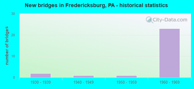
- New bridges - historical statistics
- 21930-1939
- 11940-1949
- 11950-1959
- 231960-1969

- Reconstructed bridges - Historical Statistics
- 31980-1989
- 01990-1999
- 12000-2009


- Bridge Condition - Deck
- 15.4%Good
- 23.1%Satisfactory
- 53.8%Fair
- 7.7%Poor

- Bridge Condition - Superstructure
- 23.1%Good
- 38.5%Satisfactory
- 30.8%Fair
- 7.7%Poor

- Bridge Condition - Substructure
- 7.7%Good
- 38.5%Satisfactory
- 46.2%Fair
- 7.7%Poor

- Bridge Condition - Channel
- 14.3%Very good
- 14.3%Good
- 28.6%Fair
- 42.9%Poor
Find on map >> Show street view
Structure Number: 13003, Location: VERNON TOWNSHIP (Lat: 41.652575, Lng: -80.205039), Route carried "on" structure: Interstate 79, Year Built: 1969, Year Reconstructed: 1994, Status: Open, Structure Length: 3.35m (10.99ft), Average Daily Traffic: 7,763 (year 2021), Truck Traffic: 20%, Average Future Daily Traffic: 11,433 (year 2032), Design Load: HS 20+Mod, Features Intersected: OVER SR 0102
Minimum Vertical Clearance: 30+ m (98+ ft), Kilometerpoint: 20.960, Lanes on structure: 2, Lanes under structure: 2, Base Highway Network: Yes, Owner: State Highway Agency, Approaching Roadway Width: 11.6m (38.1ft), Skew: 12 degrees, Material/Design: Prestressed concrete, Design/Construction: Box Beam or Girders - Single/Spread, Number Of Spans In Main Unit: 3, Length of Maximum Span: 13.1m (43.0ft), Curb or Sidewalk Widths: Left: 0.2m (0.7ft), Right: 0.2m (0.7ft), Curb-To-Curb Width: 11.9m (39.0ft), Out-to-Out Width: 13.1m (43.0ft)
Condition: Deck: Satisfactory, Superstructure: Satisfactory, Substructure: Satisfactory, Operating Rating: 68.9 metric tons, Method Used To Determine Operating Rating: Load Factor (LF), Inventory Rating: 31.8 metric tons, Method Used To Determine Inventory Rating: Load Factor (LF), Structural Evaluation: Equal to present minimum criteria, Deck Geometry: Equal to present minimum criteria, Underclear: Meets minimum limits, Approach Roadway Alignment: Equal to present desirable criteria, Length Of Structure Improvement: 3.40m (11.15ft), Designated Inspection Frequency: Every 24 months, Inspection Date: October 2020, Bridge Improvement Cost: $12,000, Roadway Improvement Cost: $34,000, Total Project Cost: $157,000, Deck Structure Type: Concrete Cast-file-Place, Wearing Surface/Protective System: Wearing Surface: Bituminous, Membrane: Preformed Fabric
Find on map >> Show street view
Structure Number: 13004, Location: VERNON TOWNSHIP (Lat: 41.662356, Lng: -80.206889), Route carried "on" structure: Interstate 79, Year Built: 1969, Year Reconstructed: 1994, Status: Open, Structure Length: 6.64m (21.78ft), Average Daily Traffic: 7,747 (year 2021), Truck Traffic: 20%, Average Future Daily Traffic: 10,671 (year 2032), Design Load: HS 20+Mod, Features Intersected: OVER CUSSEWAGO CREEK
Minimum Vertical Clearance: 30+ m (98+ ft), Kilometerpoint: 21.762, Lanes on structure: 2, Base Highway Network: Yes, Owner: State Highway Agency, Approaching Roadway Width: 11.3m (37.1ft), Skew: 12 degrees, Material/Design: Prestressed concrete, Design/Construction: Box Beam or Girders - Single/Spread, Number Of Spans In Main Unit: 4, Length of Maximum Span: 16.5m (54.1ft), Curb or Sidewalk Widths: Left: 0.2m (0.7ft), Right: 0.2m (0.7ft), Curb-To-Curb Width: 11.9m (39.0ft), Out-to-Out Width: 13.0m (42.7ft)
Condition: Deck: Fair, Superstructure: Satisfactory, Substructure: Fair, Channel: Very good, Inventory Rating: 29.0 metric tons, Method Used To Determine Inventory Rating: Load Factor (LF), Structural Evaluation: Somewhat better than minimum adequacy, Deck Geometry: Equal to present minimum criteria, Waterway Adequacy: Superior to present desirable criteria, Approach Roadway Alignment: Equal to present desirable criteria, Length Of Structure Improvement: 7.70m (25.26ft), Designated Inspection Frequency: Every 24 months, Inspection Date: May 2021, Deck Structure Type: Concrete Cast-file-Place, Wearing Surface/Protective System: Wearing Surface: Bituminous, Membrane: Preformed Fabric
Find on map >> Show street view
Structure Number: 13005, Location: VERNON TOWNSHIP (Lat: 41.662614, Lng: -80.207328), Route carried "on" structure: Interstate 79, Year Built: 1969, Year Reconstructed: 1994, Status: Open, Structure Length: 6.64m (21.78ft), Average Daily Traffic: 7,763 (year 2021), Truck Traffic: 20%, Average Future Daily Traffic: 11,433 (year 2032), Design Load: HS 20+Mod, Features Intersected: OVER CUSSEWAGO CREEK
Minimum Vertical Clearance: 30+ m (98+ ft), Kilometerpoint: 21.760, Lanes on structure: 2, Base Highway Network: Yes, Owner: State Highway Agency, Approaching Roadway Width: 11.3m (37.1ft), Skew: 12 degrees, Material/Design: Prestressed concrete, Design/Construction: Box Beam or Girders - Single/Spread, Number Of Spans In Main Unit: 4, Length of Maximum Span: 16.5m (54.1ft), Curb or Sidewalk Widths: Left: 0.2m (0.7ft), Right: 0.2m (0.7ft), Curb-To-Curb Width: 11.7m (38.4ft), Out-to-Out Width: 13.0m (42.7ft)
Condition: Deck: Fair, Superstructure: Satisfactory, Substructure: Fair, Channel: Good, Inventory Rating: 29.0 metric tons, Method Used To Determine Inventory Rating: Load Factor (LF), Structural Evaluation: Somewhat better than minimum adequacy, Deck Geometry: Equal to present minimum criteria, Waterway Adequacy: Superior to present desirable criteria, Approach Roadway Alignment: Equal to present desirable criteria, Length Of Structure Improvement: 7.70m (25.26ft), Designated Inspection Frequency: Every 24 months, Inspection Date: May 2021, Bridge Improvement Cost: $31,000, Roadway Improvement Cost: $92,000, Total Project Cost: $421,000, Deck Structure Type: Concrete Cast-file-Place, Wearing Surface/Protective System: Wearing Surface: Bituminous, Membrane: Preformed Fabric
Find on map >> Show street view
Structure Number: 13006, Location: HAYFIELD TOWNSHIP (Lat: 41.682894, Lng: -80.206389), Route carried "on" structure: Interstate 79, Year Built: 1969, Status: Open, Structure Length: 3.14m (10.30ft), Average Daily Traffic: 7,747 (year 2021), Truck Traffic: 20%, Average Future Daily Traffic: 10,671 (year 2032), Design Load: HS 20+Mod, Features Intersected: OVER T-611,MATT ROAD
Minimum Vertical Clearance: 30+ m (98+ ft), Kilometerpoint: 24.176, Lanes on structure: 2, Lanes under structure: 2, Base Highway Network: Yes, Owner: State Highway Agency, Approaching Roadway Width: 11.6m (38.1ft), Skew: 11 degrees, Material/Design: Prestressed concrete, Design/Construction: Box Beam or Girders - Multiple, Number Of Spans In Main Unit: 3, Length of Maximum Span: 11.6m (38.1ft), Curb or Sidewalk Widths: Left: 0.2m (0.7ft), Right: 0.2m (0.7ft), Curb-To-Curb Width: 11.7m (38.4ft), Out-to-Out Width: 13.0m (42.7ft)
Condition: Deck: Fair, Superstructure: Good, Substructure: Good, Operating Rating: 62.6 metric tons, Method Used To Determine Operating Rating: Load Factor (LF), Inventory Rating: 35.4 metric tons, Method Used To Determine Inventory Rating: Load Factor (LF), Structural Evaluation: Better than present minimum criteria, Deck Geometry: Equal to present minimum criteria, Underclear: Meets minimum limits, Approach Roadway Alignment: Equal to present desirable criteria, Length Of Structure Improvement: 3.90m (12.80ft), Designated Inspection Frequency: Every 24 months, Inspection Date: March 2021, Deck Structure Type: Concrete Cast-file-Place, Wearing Surface/Protective System: Wearing Surface: Bituminous, Membrane: Preformed Fabric
Find on map >> Show street view
Structure Number: 13041, Location: VERNON TOWNSHIP (Lat: 41.639692, Lng: -80.206817), Route carried "on" structure: State highway 98, Year Built: 1937, Status: Open, Structure Length: 0.76m (2.49ft), Average Daily Traffic: 4,244 (year 2020), Truck Traffic: 5%, Average Future Daily Traffic: 5,649 (year 2032), Design Load: H 20, Features Intersected: OVER VAN HORNE RUN
Minimum Vertical Clearance: 30+ m (98+ ft), Kilometerpoint: 1.675, Lanes on structure: 2, Base Highway Network: Yes, Owner: State Highway Agency, Approaching Roadway Width: 10.7m (35.1ft), Material/Design: Concrete, Design/Construction: Tee Beam, Number Of Spans In Main Unit: 1, Length of Maximum Span: 7.0m (23.0ft), Curb-To-Curb Width: 11.2m (36.7ft), Out-to-Out Width: 13.1m (43.0ft)
Condition: Deck: Poor, Superstructure: Fair, Substructure: Fair, Channel: Poor, Operating Rating: 43.5 metric tons, Method Used To Determine Operating Rating: Load Factor (LF), Inventory Rating: 24.5 metric tons, Method Used To Determine Inventory Rating: Load Factor (LF), Structural Evaluation: Somewhat better than minimum adequacy, Deck Geometry: Somewhat better than minimum adequacy, Waterway Adequacy: Equal to present minimum criteria, Approach Roadway Alignment: Equal to present desirable criteria, Length Of Structure Improvement: 0.80m (2.62ft), Designated Inspection Frequency: Every 24 months, Inspection Date: March 2020, Wearing Surface/Protective System: Wearing Surface: Bituminous, Membrane: Preformed Fabric
Find on map >> Show street view
Structure Number: 13277, Location: HAYFIELD TOWNSHIP (Lat: 41.672322, Lng: -80.214000), Route carried "on" structure: State highway , Year Built: 1963, Status: Open, Structure Length: 4.79m (15.72ft), Average Daily Traffic: 319 (year 2017), Truck Traffic: 1%, Average Future Daily Traffic: 760 (year 2032), Design Load: HS 20, Features Intersected: OVER CUSSEWAGO CREEK, Facility Carried by Structure: SR 2034,ROGERS FRY
Minimum Vertical Clearance: 30+ m (98+ ft), Kilometerpoint: 1.086, Lanes on structure: 2, Owner: State Highway Agency, Approaching Roadway Width: 5.5m (18.0ft), Skew: 3 degrees, Material/Design: Prestressed concrete, Design/Construction: Box Beam or Girders - Multiple, Number Of Spans In Main Unit: 2, Length of Maximum Span: 23.5m (77.1ft), Curb or Sidewalk Widths: Left: 0.5m (1.6ft), Right: 0.5m (1.6ft), Curb-To-Curb Width: 8.5m (27.9ft), Out-to-Out Width: 10.2m (33.5ft)
Condition: Deck: Satisfactory, Superstructure: Satisfactory, Substructure: Fair, Channel: Poor, Operating Rating: 85.3 metric tons, Method Used To Determine Operating Rating: Load Factor (LF), Inventory Rating: 49.9 metric tons, Method Used To Determine Inventory Rating: Load Factor (LF), Structural Evaluation: Somewhat better than minimum adequacy, Deck Geometry: Equal to present minimum criteria, Waterway Adequacy: Equal to present minimum criteria, Approach Roadway Alignment: Equal to present desirable criteria, Length Of Structure Improvement: 5.70m (18.70ft), Designated Inspection Frequency: Every 24 months, Underwater Inspection Frequency: Every 24 months, Inspection Date: June 2020, Underwater Inspection Date: October 2021, Deck Structure Type: Concrete Cast-file-Place, Wearing Surface/Protective System: Wearing Surface: Bituminous, Membrane: Other
Find on map >> Show street view
Structure Number: 13278, Location: HAYFIELD TOWNSHIP (Lat: 41.671250, Lng: -80.209092), Route carried "on" structure: State highway , Year Built: 1969, Status: Open, Structure Length: 11.40m (37.40ft), Average Daily Traffic: 319 (year 2017), Truck Traffic: 1%, Average Future Daily Traffic: 760 (year 2032), Design Load: HS 20, Features Intersected: OVER SR 79,NB/SB, Facility Carried by Structure: SR 2034,ROGERS FRY
Minimum Vertical Clearance: 30+ m (98+ ft), Kilometerpoint: 1.086, Lanes on structure: 2, Lanes under structure: 8, Owner: State Highway Agency, Approaching Roadway Width: 6.4m (21.0ft), Skew: 4 degrees, Material/Design: Prestressed concrete, Design/Construction: Stringer/Multi-beam, Number Of Spans In Main Unit: 5, Length of Maximum Span: 26.5m (86.9ft), Curb or Sidewalk Widths: Left: 0.2m (0.7ft), Right: 0.2m (0.7ft), Curb-To-Curb Width: 9.6m (31.5ft), Out-to-Out Width: 10.6m (34.8ft)
Condition: Deck: Satisfactory, Superstructure: Good, Substructure: Fair, Operating Rating: 89.8 metric tons, Method Used To Determine Operating Rating: Load Factor (LF), Inventory Rating: 29.9 metric tons, Method Used To Determine Inventory Rating: Load Factor (LF), Structural Evaluation: Somewhat better than minimum adequacy, Deck Geometry: Equal to present minimum criteria, Underclear: Somewhat better than minimum adequacy, Approach Roadway Alignment: Better than present minimum criteria, Length Of Structure Improvement: 12.40m (40.68ft), Designated Inspection Frequency: Every 24 months, Inspection Date: April 2021, Deck Structure Type: Concrete Cast-file-Place, Wearing Surface/Protective System: Wearing Surface: Bituminous, Membrane: Other
Find on map >> Show street view
Structure Number: 13281, Location: VERNON TOWNSHIP (Lat: 41.646967, Lng: -80.171192), Route carried "on" structure: State highway , Year Built: 1950, Status: Open, Structure Length: 4.79m (15.72ft), Average Daily Traffic: 2,472 (year 2021), Truck Traffic: 7%, Average Future Daily Traffic: 3,083 (year 2032), Design Load: H 20, Features Intersected: OVER CUSSEWAGO CREEK, Facility Carried by Structure: SR 2039,DUNHAM ST.
Minimum Vertical Clearance: 30+ m (98+ ft), Kilometerpoint: 0.000, Lanes on structure: 2, Owner: State Highway Agency, Approaching Roadway Width: 6.1m (20.0ft), Skew: 3 degrees, Material/Design: Steel, Design/Construction: Stringer/Multi-beam, Number Of Spans In Main Unit: 2, Length of Maximum Span: 22.9m (75.1ft), Curb or Sidewalk Widths: Left: 0.2m (0.7ft), Right: 1.5m (4.9ft), Curb-To-Curb Width: 7.9m (25.9ft), Out-to-Out Width: 10.4m (34.1ft)
Condition: Deck: Fair, Superstructure: Poor, Substructure: Poor, Channel: Fair, Operating Rating: 89.8 metric tons, Method Used To Determine Operating Rating: Load Factor (LF), Inventory Rating: 58.1 metric tons, Method Used To Determine Inventory Rating: Load Factor (LF), Structural Evaluation: Meets minimum limits, Deck Geometry: High priority of corrective action, Waterway Adequacy: Better than present minimum criteria, Approach Roadway Alignment: Equal to present desirable criteria, Length Of Structure Improvement: 5.70m (18.70ft), Designated Inspection Frequency: Every 24 months, Underwater Inspection Frequency: Every 60 months, Other Special Inspection Frequency: Every 12 months, Inspection Date: June 2021, Underwater Inspection Date: September 2021, Other Special Inspection Date: June 2019, Bridge Improvement Cost: $46,000, Roadway Improvement Cost: $134,000, Total Project Cost: $615,000, Deck Structure Type: Closed Grating, Wearing Surface/Protective System: Wearing Surface: Bituminous
Find on map >> Show street view
Structure Number: 13315, Location: VERNON TOWNSHIP (Lat: 41.647528, Lng: -80.203700), Route carried "on" structure: State highway , Year Built: 1969, Status: Open, Structure Length: 7.92m (25.98ft), Average Daily Traffic: 4,964 (year 2022), Truck Traffic: 1%, Average Future Daily Traffic: 5,777 (year 2032), Design Load: HS 20, Features Intersected: OVER SR 79 NB/SB,RP SHAF, Facility Carried by Structure: SR 3016,HARMONSBG
Minimum Vertical Clearance: 30+ m (98+ ft), Kilometerpoint: 17.202, Lanes on structure: 2, Lanes under structure: 8, Owner: State Highway Agency, Approaching Roadway Width: 8.2m (26.9ft), Material/Design: Prestressed concrete, Design/Construction: Box Beam or Girders - Single/Spread, Number Of Spans In Main Unit: 5, Length of Maximum Span: 17.7m (58.1ft), Curb or Sidewalk Widths: Left: 0.2m (0.7ft), Right: 0.2m (0.7ft), Curb-To-Curb Width: 10.2m (33.5ft), Out-to-Out Width: 11.4m (37.4ft)
Condition: Deck: Fair, Superstructure: Satisfactory, Substructure: Satisfactory, Operating Rating: 89.8 metric tons, Method Used To Determine Operating Rating: Load Factor (LF), Inventory Rating: 42.6 metric tons, Method Used To Determine Inventory Rating: Load Factor (LF), Structural Evaluation: Equal to present minimum criteria, Deck Geometry: Meets minimum limits, Underclear: Somewhat better than minimum adequacy, Approach Roadway Alignment: Better than present minimum criteria, Length Of Structure Improvement: 8.90m (29.20ft), Designated Inspection Frequency: Every 24 months, Inspection Date: October 2021, Deck Structure Type: Concrete Cast-file-Place, Wearing Surface/Protective System: Wearing Surface: Bituminous, Membrane: Other
Find on map >> Show street view
Structure Number: 13355, Location: HAYFIELD TOWNSHIP (Lat: 41.698722, Lng: -80.199914), Route carried "on" structure: State highway , Year Built: 1969, Year Reconstructed: 2009, Status: Open, Structure Length: 12.44m (40.81ft), Average Daily Traffic: 1,299 (year 2022), Truck Traffic: 6%, Average Future Daily Traffic: 1,570 (year 2032), Design Load: HS 20+Mod, Features Intersected: OVER SR 79,NB/SB, Facility Carried by Structure: SR 4009,MOSIERTOWN
Minimum Vertical Clearance: 30+ m (98+ ft), Kilometerpoint: 5.349, Lanes on structure: 2, Lanes under structure: 8, Owner: State Highway Agency, Approaching Roadway Width: 6.1m (20.0ft), Skew: 4 degrees, Material/Design: Prestressed concrete, Design/Construction: Stringer/Multi-beam, Number Of Spans In Main Unit: 6, Length of Maximum Span: 25.6m (84.0ft), Curb or Sidewalk Widths: Left: 0.2m (0.7ft), Right: 0.2m (0.7ft), Curb-To-Curb Width: 9.0m (29.5ft), Out-to-Out Width: 10.3m (33.8ft)
Condition: Deck: Good, Superstructure: Good, Substructure: Satisfactory, Operating Rating: 81.6 metric tons, Method Used To Determine Operating Rating: Load Factor (LF), Inventory Rating: 33.6 metric tons, Method Used To Determine Inventory Rating: Load Factor (LF), Structural Evaluation: Equal to present minimum criteria, Deck Geometry: Somewhat better than minimum adequacy, Underclear: Somewhat better than minimum adequacy, Approach Roadway Alignment: Better than present minimum criteria, Length Of Structure Improvement: 13.40m (43.96ft), Designated Inspection Frequency: Every 24 months, Inspection Date: May 2021, Bridge Improvement Cost: $106,000, Roadway Improvement Cost: $313,000, Total Project Cost: $1,433,000, Deck Structure Type: Concrete Cast-file-Place, Wearing Surface/Protective System: Wearing Surface: Bituminous, Membrane: Preformed Fabric
Find on map >> Show street view
Structure Number: 22604, Location: 1 MI.W. OF T.R. 343 (Lat: 40.436278, Lng: -76.435992), Route carried "on" structure: US 22, Year Built: 1939, Status: Open, Structure Length: 0.88m (2.89ft), Average Daily Traffic: 7,236 (year 2022), Truck Traffic: 7%, Average Future Daily Traffic: 8,776 (year 2032), Design Load: H 20, Features Intersected: DEEP RUN
Minimum Vertical Clearance: 30+ m (98+ ft), Kilometerpoint: 19.063, Lanes on structure: 4, Base Highway Network: Yes, Owner: State Highway Agency, Approaching Roadway Width: 20.1m (65.9ft), Skew: 31 degrees, Material/Design: Concrete, Design/Construction: Tee Beam, Number Of Spans In Main Unit: 1, Length of Maximum Span: 7.9m (25.9ft), Curb or Sidewalk Widths: Left: 0.2m (0.7ft), Right: 0.2m (0.7ft), Curb-To-Curb Width: 20.1m (65.9ft), Out-to-Out Width: 21.8m (71.5ft)
Condition: Deck: Fair, Superstructure: Fair, Substructure: Fair, Channel: Fair, Operating Rating: 57.2 metric tons, Method Used To Determine Operating Rating: Load Factor (LF), Inventory Rating: 34.5 metric tons, Method Used To Determine Inventory Rating: Load Factor (LF), Structural Evaluation: Somewhat better than minimum adequacy, Deck Geometry: Better than present minimum criteria, Waterway Adequacy: Equal to present minimum criteria, Approach Roadway Alignment: Equal to present desirable criteria, Length Of Structure Improvement: 1.60m (5.25ft), Designated Inspection Frequency: Every 24 months, Inspection Date: October 2019, Bridge Improvement Cost: $32,000, Roadway Improvement Cost: $94,000, Total Project Cost: $432,000, Deck Structure Type: Concrete Cast-file-Place, Wearing Surface/Protective System: Wearing Surface: Bituminous
Find on map >> Show street view
Structure Number: 22605, Location: 0.5 MILE SOUTH FREDRICKSB (Lat: 40.440750, Lng: -76.427167), Route carried "on" structure: US 22, Year Built: 1946, Status: Open, Structure Length: 0.76m (2.49ft), Average Daily Traffic: 9,287 (year 2022), Truck Traffic: 7%, Average Future Daily Traffic: 9,788 (year 2032), Features Intersected: BEACH RUN
Minimum Vertical Clearance: 30+ m (98+ ft), Kilometerpoint: 19.724, Lanes on structure: 4, Base Highway Network: Yes, Owner: State Highway Agency, Approaching Roadway Width: 20.1m (65.9ft), Skew: 34 degrees, Material/Design: Concrete, Design/Construction: Culvert, Number Of Spans In Main Unit: 1, Length of Maximum Span: 7.6m (24.9ft)
Condition: Channel: Poor, Culverts: Poor, Operating Rating: 58.1 metric tons, Method Used To Determine Operating Rating: Field evaluation and documented engineering judgment, Inventory Rating: 34.5 metric tons, Method Used To Determine Inventory Rating: Field evaluation and documented engineering judgment, Structural Evaluation: Meets minimum limits, Waterway Adequacy: Equal to present minimum criteria, Approach Roadway Alignment: Equal to present desirable criteria, Length Of Structure Improvement: 1.50m (4.92ft), Designated Inspection Frequency: Every 24 months, Underwater Inspection Frequency: Every 24 months, Inspection Date: April 2020, Underwater Inspection Date: April 2020
Find on map >> Show street view
Structure Number: 22628, Location: 1.5 MI.W. OF EXIT #1 (Lat: 40.449961, Lng: -76.446128), Route carried "on" structure: Interstate 78, Year Built: 1969, Status: Open, Structure Length: 2.65m (8.69ft), Average Daily Traffic: 22,030 (year 2021), Truck Traffic: 19%, Average Future Daily Traffic: 20,217 (year 2032), Design Load: HS 20, Features Intersected: T-486, SUGAR RD.
Minimum Vertical Clearance: 30+ m (98+ ft), Kilometerpoint: 7.226, Lanes on structure: 2, Lanes under structure: 2, Base Highway Network: Yes, Owner: State Highway Agency, Approaching Roadway Width: 11.6m (38.1ft), Skew: 12 degrees, Material/Design: Concrete continuous, Design/Construction: Slab, Number Of Spans In Main Unit: 3, Length of Maximum Span: 11.0m (36.1ft), Curb or Sidewalk Widths: Left: 0.2m (0.7ft), Right: 0.2m (0.7ft), Curb-To-Curb Width: 11.7m (38.4ft), Out-to-Out Width: 13.0m (42.7ft)
Condition: Deck: Fair, Superstructure: Fair, Substructure: Satisfactory, Operating Rating: 67.1 metric tons, Method Used To Determine Operating Rating: Load Factor (LF), Inventory Rating: 40.8 metric tons, Method Used To Determine Inventory Rating: Load Factor (LF), Structural Evaluation: Somewhat better than minimum adequacy, Deck Geometry: Equal to present minimum criteria, Underclear: Equal to present minimum criteria, Approach Roadway Alignment: Equal to present desirable criteria, Length Of Structure Improvement: 3.40m (11.15ft), Designated Inspection Frequency: Every 24 months, Inspection Date: October 2019, Bridge Improvement Cost: $10,000, Roadway Improvement Cost: $31,000, Total Project Cost: $140,000, Wearing Surface/Protective System: Wearing Surface: Latex Concrete
Find on map >> Show street view
Structure Number: 22729, Location: 0.5 MI.W. OF EXIT #1 (Lat: 40.451667, Lng: -76.435000), Route carried "on" structure: State highway , Year Built: 1969, Status: Open, Structure Length: 7.47m (24.51ft), Average Daily Traffic: 651 (year 2022), Truck Traffic: 7%, Average Future Daily Traffic: 944 (year 2032), Design Load: HS 20, Features Intersected: I-78; SR 0078, Facility Carried by Structure: SR 1005
Minimum Vertical Clearance: 30+ m (98+ ft), Kilometerpoint: 0.000, Lanes on structure: 2, Lanes under structure: 8, Owner: State Highway Agency, Approaching Roadway Width: 5.5m (18.0ft), Material/Design: Prestressed concrete, Design/Construction: Box Beam or Girders - Single/Spread, Number Of Spans In Main Unit: 5, Length of Maximum Span: 17.7m (58.1ft), Curb or Sidewalk Widths: Left: 0.2m (0.7ft), Right: 0.2m (0.7ft), Curb-To-Curb Width: 9.0m (29.5ft), Out-to-Out Width: 10.2m (33.5ft)
Condition: Deck: Good, Superstructure: Fair, Substructure: Satisfactory, Operating Rating: 68.0 metric tons, Method Used To Determine Operating Rating: Load Factor (LF), Inventory Rating: 21.8 metric tons, Method Used To Determine Inventory Rating: Load Factor (LF), Structural Evaluation: Somewhat better than minimum adequacy, Deck Geometry: Somewhat better than minimum adequacy, Underclear: Equal to present minimum criteria, Approach Roadway Alignment: Equal to present desirable criteria, Length Of Structure Improvement: 8.40m (27.56ft), Designated Inspection Frequency: Every 24 months, Inspection Date: November 2019, Deck Structure Type: Concrete Cast-file-Place, Wearing Surface/Protective System: Wearing Surface: Latex Concrete
Find on map >> Show street view
Structure Number: 13001, Location: VERNON TOWNSHIP (Lat: 41.652392, Lng: -80.204644), Route carried "under" structure: State highway 102, Year Built: 1969, Structure Length: 0. m, Average Daily Traffic: 1,673 (year 2022), Truck Traffic: 8%, Features Intersected: OVER SR 0102, Facility Carried by Structure: SR 79,NB
Minimum Vertical Clearance: 4.83m (15.85ft), Kilometerpoint: 6.104, Lanes on structure: 2, Lanes under structure: 2, Material/Design: Prestressed concrete, Design/Construction: Box Beam or Girders - Single/Spread, Length of Maximum Span: 13.1m (43.0ft)
Find on map >> Show street view
Structure Number: 13003, Location: VERNON TOWNSHIP (Lat: 41.652575, Lng: -80.205039), Route carried "under" structure: State highway 102, Year Built: 1969, Structure Length: 0. m, Average Daily Traffic: 1,673 (year 2022), Truck Traffic: 8%, Features Intersected: OVER SR 0102, Facility Carried by Structure: SR 79,SB
Minimum Vertical Clearance: 4.32m (14.17ft), Kilometerpoint: 6.104, Lanes on structure: 2, Lanes under structure: 2, Material/Design: Prestressed concrete, Design/Construction: Box Beam or Girders - Single/Spread, Length of Maximum Span: 13.1m (43.0ft)
Find on map >> Show street view
Structure Number: 13006, Location: HAYFIELD TOWNSHIP (Lat: 41.682894, Lng: -80.206389), Route carried "under" structure: City street T611, Year Built: 1969, Structure Length: 0. m, Average Daily Traffic: 50 (year 2003), Features Intersected: OVER T-611,MATT ROAD, Facility Carried by Structure: SR 79,NB
Minimum Vertical Clearance: 4.29m (14.07ft), Kilometerpoint: 0.000, Lanes on structure: 2, Lanes under structure: 2, Material/Design: Prestressed concrete, Design/Construction: Box Beam or Girders - Multiple, Length of Maximum Span: 11.6m (38.1ft)
Find on map >> Show street view
Structure Number: 13007, Location: HAYFIELD TOWNSHIP (Lat: 41.682967, Lng: -80.207114), Route carried "under" structure: City street 611, Year Built: 1969, Structure Length: 0. m, Average Daily Traffic: 50 (year 2003), Features Intersected: OVER T-611,MATT ROAD, Facility Carried by Structure: SR 79,SB
Minimum Vertical Clearance: 4.34m (14.24ft), Kilometerpoint: 0.000, Lanes on structure: 2, Lanes under structure: 2, Material/Design: Prestressed concrete, Design/Construction: Box Beam or Girders - Multiple, Length of Maximum Span: 11.6m (38.1ft)
Find on map >> Show street view
Structure Number: 13278, Location: HAYFIELD TOWNSHIP (Lat: 41.671250, Lng: -80.209092), Route carried "under" structure: Interstate 79, Year Built: 1969, Structure Length: 0. m, Average Daily Traffic: 7,747 (year 2021), Truck Traffic: 20%, Features Intersected: OVER SR 79,NB/SB, Facility Carried by Structure: SR 2034,ROGERS FRY
Minimum Vertical Clearance: 6.50m (21.33ft), Kilometerpoint: 22.573, Lanes on structure: 2, Lanes under structure: 4, Material/Design: Prestressed concrete, Design/Construction: Stringer/Multi-beam, Length of Maximum Span: 26.5m (86.9ft)
Find on map >> Show street view
Structure Number: 13278, Location: HAYFIELD TOWNSHIP (Lat: 41.671250, Lng: -80.209092), Route carried "under" structure: Interstate 79, Year Built: 1969, Structure Length: 0. m, Average Daily Traffic: 7,763 (year 2021), Truck Traffic: 20%, Features Intersected: OVER SR 79,NB/SB, Facility Carried by Structure: SR 2034,ROGERS FRY
Minimum Vertical Clearance: 5.13m (16.83ft), Kilometerpoint: 22.563, Lanes on structure: 2, Lanes under structure: 4, Material/Design: Prestressed concrete, Design/Construction: Stringer/Multi-beam, Length of Maximum Span: 26.5m (86.9ft)
Find on map >> Show street view
Structure Number: 13315, Location: VERNON TOWNSHIP (Lat: 41.647528, Lng: -80.203700), Route carried "under" structure: Interstate 79, Year Built: 1969, Structure Length: 0. m, Average Daily Traffic: 7,763 (year 2021), Truck Traffic: 20%, Features Intersected: OVER SR 79 NB/SB,RP SHAF, Facility Carried by Structure: SR 3016,HARMONSBG
Minimum Vertical Clearance: 5.05m (16.57ft), Kilometerpoint: 20.143, Lanes on structure: 2, Lanes under structure: 4, Material/Design: Prestressed concrete, Design/Construction: Box Beam or Girders - Single/Spread, Length of Maximum Span: 17.7m (58.1ft)
Find on map >> Show street view
Structure Number: 13315, Location: VERNON TOWNSHIP (Lat: 41.647528, Lng: -80.203700), Route carried "under" structure: Interstate 79, Year Built: 1969, Structure Length: 0. m, Average Daily Traffic: 7,747 (year 2021), Truck Traffic: 20%, Features Intersected: OVER SR 79 NB/SB,RP SHAF, Facility Carried by Structure: SR 3016,HARMONSBG
Minimum Vertical Clearance: 5.31m (17.42ft), Kilometerpoint: 20.159, Lanes on structure: 2, Lanes under structure: 4, Material/Design: Prestressed concrete, Design/Construction: Box Beam or Girders - Single/Spread, Length of Maximum Span: 17.7m (58.1ft)
Find on map >> Show street view
Structure Number: 13355, Location: HAYFIELD TOWNSHIP (Lat: 41.698722, Lng: -80.199914), Route carried "under" structure: Interstate 79, Year Built: 1969, Structure Length: 0. m, Average Daily Traffic: 7,763 (year 2021), Truck Traffic: 20%, Features Intersected: OVER SR 79,NB/SB, Facility Carried by Structure: SR 4009,MOSIERTOWN
Minimum Vertical Clearance: 5.16m (16.93ft), Kilometerpoint: 25.859, Lanes on structure: 2, Lanes under structure: 4, Material/Design: Prestressed concrete, Design/Construction: Stringer/Multi-beam, Length of Maximum Span: 25.6m (84.0ft)
Find on map >> Show street view
Structure Number: 13355, Location: HAYFIELD TOWNSHIP (Lat: 41.698722, Lng: -80.199914), Route carried "under" structure: Interstate 79, Year Built: 1969, Structure Length: 0. m, Average Daily Traffic: 7,747 (year 2021), Truck Traffic: 20%, Features Intersected: OVER SR 79,NB/SB, Facility Carried by Structure: SR 4009,MOSIERTOWN
Minimum Vertical Clearance: 5.03m (16.50ft), Kilometerpoint: 25.851, Lanes on structure: 2, Lanes under structure: 4, Material/Design: Prestressed concrete, Design/Construction: Stringer/Multi-beam, Length of Maximum Span: 25.6m (84.0ft)
Find on map >> Show street view
Structure Number: 22628, Location: 1.5 MI.W. OF EXIT #1 (Lat: 40.449961, Lng: -76.446128), Route carried "under" structure: City street , Year Built: 1969, Structure Length: 0. m, Average Daily Traffic: 1 (year 2003), Features Intersected: T-486, SUGAR RD., Facility Carried by Structure: I-78 EB; SR 0078
Minimum Vertical Clearance: 4.62m (15.16ft), Kilometerpoint: 0.000, Lanes on structure: 2, Lanes under structure: 2, Material/Design: Concrete continuous, Design/Construction: Slab, Length of Maximum Span: 11.0m (36.1ft)
Find on map >> Show street view
Structure Number: 22729, Location: 0.5 MI.W. OF EXIT #1 (Lat: 40.451667, Lng: -76.435000), Route carried "under" structure: Interstate 78, Year Built: 1969, Structure Length: 0. m, Average Daily Traffic: 22,030 (year 2021), Truck Traffic: 19%, Features Intersected: I-78; SR 0078, Facility Carried by Structure: SR 1005
Minimum Vertical Clearance: 5.18m (16.99ft), Kilometerpoint: 8.039, Lanes on structure: 2, Lanes under structure: 4, Material/Design: Prestressed concrete, Design/Construction: Box Beam or Girders - Single/Spread, Length of Maximum Span: 17.7m (58.1ft)
Find on map >> Show street view
Structure Number: 22729, Location: 0.5 MI.W. OF EXIT #1 (Lat: 40.451667, Lng: -76.435000), Route carried "under" structure: Interstate 78, Year Built: 1969, Structure Length: 0. m, Average Daily Traffic: 22,378 (year 2021), Truck Traffic: 21%, Features Intersected: I-78; SR 0078, Facility Carried by Structure: SR 1005
Minimum Vertical Clearance: 5.18m (16.99ft), Kilometerpoint: 8.024, Lanes on structure: 2, Lanes under structure: 4, Material/Design: Prestressed concrete, Design/Construction: Box Beam or Girders - Single/Spread, Length of Maximum Span: 17.7m (58.1ft)