Bridge Statistics for Franklin Center, New Jersey (NJ)
Condition, Traffic, Stress, Structural Evaluation, Project Costs
- National Bridge Inventory (NBI) Statistics
- 25Number of bridges
- 361ft / 110mTotal length
- $4,044,000Total costs
- 1,295,563Total average daily traffic
- 117,535Total average daily truck traffic
- National Bridge Inventory (NBI) Registered Bridges for Franklin Center
- No street view available for this location
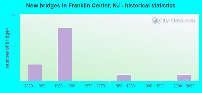
- New bridges - historical statistics
- 51950-1959
- 161960-1969
- 21980-1989
- 22000-2009

- Reconstructed bridges - Historical Statistics
- 61980-1989
- 01990-1999
- 02000-2009
- 12010-2019


- Bridge Condition - Deck
- 9.1%Very good
- 36.4%Good
- 45.5%Satisfactory
- 9.1%Poor

- Bridge Condition - Superstructure
- 33.3%Good
- 41.7%Satisfactory
- 25.0%Fair

- Bridge Condition - Substructure
- 41.7%Good
- 41.7%Satisfactory
- 16.7%Fair

- Bridge Condition - Channel
- 42.9%Good
- 28.6%Satisfactory
- 28.6%Fair

- Bridge Condition - Culverts
- 66.7%Good
- 33.3%Satisfactory
Find on map >> Show street view
Structure Number: 1231168, Location: AT I-287 EXIT 9 (Lat: 40.541031, Lng: -74.506431), Route carried "on" structure: County highway 622, Year Built: 1960, Status: Open, Structure Length: 7.28m (23.88ft), Average Daily Traffic: 16,450 (year 2020), Truck Traffic: 4%, Average Future Daily Traffic: 20,075 (year 2040), Design Load: HS 20+Mod, Features Intersected: I-287
Minimum Vertical Clearance: 30+ m (98+ ft), Kilometerpoint: 8.417, Lanes on structure: 4, Lanes under structure: 8, Base Highway Network: Yes, Owner: State Highway Agency, Approaching Roadway Width: 16.5m (54.1ft), Skew: 31 degrees, Material/Design: Steel, Design/Construction: Stringer/Multi-beam, Number Of Spans In Main Unit: 4, Length of Maximum Span: 27.1m (88.9ft), Curb or Sidewalk Widths: Left: 2.1m (6.9ft), Right: 2.1m (6.9ft), Curb-To-Curb Width: 16.5m (54.1ft), Out-to-Out Width: 22.1m (72.5ft)
Condition: Deck: Poor, Superstructure: Satisfactory, Substructure: Fair, Operating Rating: 73.5 metric tons, Method Used To Determine Operating Rating: Load Factor (LF), Inventory Rating: 44.5 metric tons, Method Used To Determine Inventory Rating: Load Factor (LF), Structural Evaluation: Somewhat better than minimum adequacy, Deck Geometry: Meets minimum limits, Underclear: Somewhat better than minimum adequacy, Approach Roadway Alignment: Equal to present desirable criteria, Length Of Structure Improvement: 7.28m (23.88ft), Designated Inspection Frequency: Every 24 months, Inspection Date: July 2020, Bridge Improvement Cost: $3,466,000, Roadway Improvement Cost: $50,000, Total Project Cost: $4,044,000 ( Estimate for 2020), Deck Structure Type: Concrete Cast-file-Place, Wearing Surface/Protective System: Wearing Surface: Bituminous
Find on map >> Show street view
Structure Number: 1231169, Location: AT I-287 EXIT 10 (Lat: 40.539350, Lng: -74.512989), Route carried "on" structure: Interstate 287, Year Built: 1959, Year Reconstructed: 1986, Status: Open, Structure Length: 21.67m (71.10ft), Average Daily Traffic: 130,026 (year 2021), Truck Traffic: 9%, Average Future Daily Traffic: 158,656 (year 2041), Design Load: HS 20+Mod, Features Intersected: RARITAN R,D&R,EASTON AVE
Minimum Vertical Clearance: 30+ m (98+ ft), Kilometerpoint: 16.480, Lanes on structure: 8, Lanes under structure: 2, Base Highway Network: Yes, Owner: State Highway Agency, Approaching Roadway Width: 33.2m (108.9ft), Skew: 33 degrees, Material/Design: Prestressed concrete, Design/Construction: Stringer/Multi-beam, Number Of Spans In Main Unit: 11, Length of Maximum Span: 21.6m (70.9ft), Curb-To-Curb Width: 33.2m (108.9ft), Out-to-Out Width: 35.1m (115.2ft)
Condition: Deck: Good, Superstructure: Satisfactory, Substructure: Satisfactory, Channel: Good, Operating Rating: 42.6 metric tons, Method Used To Determine Operating Rating: Load and Resistance Factor (LRFR), Inventory Rating: 25.4 metric tons, Method Used To Determine Inventory Rating: Load and Resistance Factor (LRFR), Structural Evaluation: Equal to present minimum criteria, Deck Geometry: Meets minimum limits, Underclear: Somewhat better than minimum adequacy, Waterway Adequacy: Superior to present desirable criteria, Approach Roadway Alignment: Equal to present desirable criteria, Designated Inspection Frequency: Every 24 months, Underwater Inspection Frequency: Every 48 months, Inspection Date: April 2021, Underwater Inspection Date: May 2021, Deck Structure Type: Concrete Cast-file-Place, Wearing Surface/Protective System: Wearing Surface: Latex Concrete
Find on map >> Show street view
Structure Number: 181215, Location: AT I-287 EXIT 10 (Lat: 40.539761, Lng: -74.514489), Route carried "on" structure: Ramp Interstate 287, Year Built: 1960, Year Reconstructed: 2010, Status: Open, Structure Length: 3.20m (10.50ft), Average Daily Traffic: 16,130 (year 2021), Truck Traffic: 9%, Average Future Daily Traffic: 19,356 (year 2041), Design Load: HL 93, Features Intersected: I-287 RAMP "B"
Minimum Vertical Clearance: 30+ m (98+ ft), Kilometerpoint: 16.785, Lanes on structure: 1, Lanes under structure: 1, Owner: State Highway Agency, Approaching Roadway Width: 8.0m (26.2ft), Skew: 1 degrees, Material/Design: Steel, Design/Construction: Stringer/Multi-beam, Number Of Spans In Main Unit: 3, Length of Maximum Span: 12.2m (40.0ft), Curb-To-Curb Width: 8.0m (26.2ft), Out-to-Out Width: 9.0m (29.5ft)
Condition: Deck: Very good, Superstructure: Good, Substructure: Satisfactory, Operating Rating: 68.7 metric tons, Method Used To Determine Operating Rating: Load and Resistance Factor Rating (LRFR) rating reported by rating factor(RF) method using HL-93 loadings, Inventory Rating: 53.1 metric tons, Method Used To Determine Inventory Rating: Load and Resistance Factor Rating (LRFR) rating reported by rating factor(RF) method using HL-93 loadings, Structural Evaluation: Equal to present minimum criteria, Deck Geometry: Superior to present desirable criteria, Underclear: Somewhat better than minimum adequacy, Approach Roadway Alignment: Somewhat better than minimum adequacy, Designated Inspection Frequency: Every 24 months, Inspection Date: June 2021, Deck Structure Type: Concrete Precast Panels, Wearing Surface/Protective System: Wearing Surface: Monolithic Concrete, Deck Protection: Epoxy Coated Reinforcing
Find on map >> Show street view
Structure Number: 1812151, Location: I-287 INT.10 (Lat: 40.539389, Lng: -74.516361), Route carried "on" structure: Interstate 287, Year Built: 1959, Year Reconstructed: 1985, Status: Open, Structure Length: 3.47m (11.38ft), Average Daily Traffic: 72,180 (year 2020), Truck Traffic: 9%, Average Future Daily Traffic: 88,080 (year 2040), Design Load: HS 20+Mod, Features Intersected: CR 527 SB (EASTON AVE)
Minimum Vertical Clearance: 30+ m (98+ ft), Kilometerpoint: 16.834, Lanes on structure: 4, Lanes under structure: 2, Base Highway Network: Yes, Owner: State Highway Agency, Approaching Roadway Width: 20.7m (67.9ft), Skew: 2 degrees, Material/Design: Prestressed concrete, Design/Construction: Stringer/Multi-beam, Number Of Spans In Main Unit: 3, Length of Maximum Span: 13.4m (44.0ft), Curb-To-Curb Width: 20.7m (67.9ft), Out-to-Out Width: 21.8m (71.5ft)
Condition: Deck: Good, Superstructure: Fair, Substructure: Good, Operating Rating: 42.6 metric tons, Method Used To Determine Operating Rating: Load Factor (LF), Inventory Rating: 25.4 metric tons, Method Used To Determine Inventory Rating: Load Factor (LF), Structural Evaluation: Somewhat better than minimum adequacy, Deck Geometry: Equal to present minimum criteria, Underclear: Meets minimum limits, Approach Roadway Alignment: Equal to present desirable criteria, Designated Inspection Frequency: Every 24 months, Inspection Date: June 2020, Deck Structure Type: Concrete Cast-file-Place, Wearing Surface/Protective System: Wearing Surface: Latex Concrete, Deck Protection: Epoxy Coated Reinforcing
Find on map >> Show street view
Structure Number: 1812152, Location: 0.08 MI. NO. OF RARITAN R (Lat: 40.539000, Lng: -74.516511), Route carried "on" structure: Interstate 287, Year Built: 1960, Year Reconstructed: 1986, Status: Open, Structure Length: 3.41m (11.19ft), Average Daily Traffic: 59,858 (year 2021), Truck Traffic: 9%, Average Future Daily Traffic: 71,829 (year 2041), Design Load: HS 20, Features Intersected: EASTON AVE SB
Minimum Vertical Clearance: 30+ m (98+ ft), Kilometerpoint: 16.816, Lanes on structure: 3, Lanes under structure: 2, Base Highway Network: Yes, Owner: State Highway Agency, Approaching Roadway Width: 15.2m (49.9ft), Skew: 2 degrees, Material/Design: Prestressed concrete, Design/Construction: Stringer/Multi-beam, Number Of Spans In Main Unit: 3, Length of Maximum Span: 17.7m (58.1ft), Curb-To-Curb Width: 15.2m (49.9ft), Out-to-Out Width: 16.9m (55.4ft)
Condition: Deck: Good, Superstructure: Fair, Substructure: Good, Operating Rating: 39.0 metric tons, Method Used To Determine Operating Rating: Load Factor (LF), Inventory Rating: 23.6 metric tons, Method Used To Determine Inventory Rating: Load Factor (LF), Structural Evaluation: Somewhat better than minimum adequacy, Deck Geometry: Meets minimum limits, Underclear: Meets minimum limits, Approach Roadway Alignment: Equal to present desirable criteria, Designated Inspection Frequency: Every 24 months, Inspection Date: May 2021, Deck Structure Type: Concrete Cast-file-Place, Wearing Surface/Protective System: Wearing Surface: Latex Concrete, Deck Protection: Epoxy Coated Reinforcing
Find on map >> Show street view
Structure Number: 1812153, Location: 0.45 MI. NO. OF INTRCH 10 (Lat: 40.539211, Lng: -74.521611), Route carried "on" structure: City street , Year Built: 1960, Status: Open, Structure Length: 8.84m (29.00ft), Average Daily Traffic: 8,555 (year 2021), Truck Traffic: 3%, Average Future Daily Traffic: 10,438 (year 2041), Design Load: HS 20, Features Intersected: I-287, Facility Carried by Structure: DAVIDSON AVE.
Minimum Vertical Clearance: 30+ m (98+ ft), Kilometerpoint: 1.770, Lanes on structure: 2, Lanes under structure: 8, Owner: State Highway Agency, Approaching Roadway Width: 9.1m (29.9ft), Skew: 2 degrees, Material/Design: Steel, Design/Construction: Stringer/Multi-beam, Number Of Spans In Main Unit: 4, Length of Maximum Span: 32.0m (105.0ft), Curb or Sidewalk Widths: Left: 1.8m (5.9ft), Right: 1.2m (3.9ft), Curb-To-Curb Width: 9.1m (29.9ft), Out-to-Out Width: 13.6m (44.6ft)
Condition: Deck: Satisfactory, Superstructure: Good, Substructure: Satisfactory, Operating Rating: 79.8 metric tons, Method Used To Determine Operating Rating: Load Factor (LF), Inventory Rating: 48.1 metric tons, Method Used To Determine Inventory Rating: Load Factor (LF), Structural Evaluation: Equal to present minimum criteria, Deck Geometry: Meets minimum limits, Underclear: Somewhat better than minimum adequacy, Approach Roadway Alignment: Equal to present desirable criteria, Designated Inspection Frequency: Every 24 months, Inspection Date: April 2021, Deck Structure Type: Concrete Cast-file-Place, Wearing Surface/Protective System: Wearing Surface: Monolithic Concrete
Find on map >> Show street view
Structure Number: 1812154, Location: 2.46 mi S of Exit 13 (Lat: 40.541231, Lng: -74.526669), Route carried "on" structure: Interstate 287, Year Built: 1959, Status: Open, Structure Length: 0.64m (2.10ft), Average Daily Traffic: 126,511 (year 2019), Truck Traffic: 9%, Average Future Daily Traffic: 177,115 (year 2039), Design Load: HS 20, Features Intersected: SKY BROOK
Minimum Vertical Clearance: 30+ m (98+ ft), Kilometerpoint: 17.767, Lanes on structure: 6, Base Highway Network: Yes, Owner: State Highway Agency, Approaching Roadway Width: 35.1m (115.2ft), Skew: 22 degrees, Material/Design: Concrete, Design/Construction: Culvert, Number Of Spans In Main Unit: 1, Length of Maximum Span: 6.4m (21.0ft)
Condition: Channel: Fair, Culverts: Satisfactory, Inventory Rating: 64.4 metric tons, Method Used To Determine Inventory Rating: Load Factor (LF), Structural Evaluation: Equal to present minimum criteria, Waterway Adequacy: Equal to present desirable criteria, Approach Roadway Alignment: Equal to present desirable criteria, Designated Inspection Frequency: Every 24 months, Inspection Date: June 2021
Find on map >> Show street view
Structure Number: 1812155, Location: 0.8 M SOUTH OF CANAL RD (Lat: 40.544639, Lng: -74.533850), Route carried "on" structure: Interstate 287, Year Built: 1960, Year Reconstructed: 1986, Status: Open, Structure Length: 4.27m (14.01ft), Average Daily Traffic: 80,379 (year 2021), Truck Traffic: 9%, Average Future Daily Traffic: 96,455 (year 2041), Design Load: HS 20, Features Intersected: ELIZABETH AVE (CR621)
Minimum Vertical Clearance: 30+ m (98+ ft), Kilometerpoint: 18.491, Lanes on structure: 3, Lanes under structure: 2, Base Highway Network: Yes, Owner: State Highway Agency, Approaching Roadway Width: 14.9m (48.9ft), Skew: 2 degrees, Material/Design: Prestressed concrete, Design/Construction: Stringer/Multi-beam, Number Of Spans In Main Unit: 3, Length of Maximum Span: 21.0m (68.9ft), Curb-To-Curb Width: 15.8m (51.8ft), Out-to-Out Width: 16.9m (55.4ft)
Condition: Deck: Satisfactory, Superstructure: Satisfactory, Substructure: Good, Operating Rating: 51.7 metric tons, Method Used To Determine Operating Rating: Load Factor (LF), Inventory Rating: 30.8 metric tons, Method Used To Determine Inventory Rating: Load Factor (LF), Structural Evaluation: Equal to present minimum criteria, Deck Geometry: Somewhat better than minimum adequacy, Underclear: Equal to present minimum criteria, Approach Roadway Alignment: Equal to present desirable criteria, Designated Inspection Frequency: Every 24 months, Inspection Date: April 2021, Deck Structure Type: Concrete Cast-file-Place, Wearing Surface/Protective System: Wearing Surface: Latex Concrete, Deck Protection: Epoxy Coated Reinforcing
Find on map >> Show street view
Structure Number: 1812156, Location: 0.8 M SOUTH OF CANAL RD (Lat: 40.544569, Lng: -74.534369), Route carried "on" structure: Interstate 287, Year Built: 1961, Year Reconstructed: 1986, Status: Open, Structure Length: 4.30m (14.11ft), Average Daily Traffic: 123,264 (year 2021), Truck Traffic: 9%, Average Future Daily Traffic: 147,917 (year 2041), Design Load: HS 20, Features Intersected: ELIZABETH AVE (CR 621)
Minimum Vertical Clearance: 30+ m (98+ ft), Kilometerpoint: 18.491, Lanes on structure: 3, Lanes under structure: 2, Base Highway Network: Yes, Owner: State Highway Agency, Approaching Roadway Width: 14.9m (48.9ft), Skew: 2 degrees, Material/Design: Prestressed concrete, Design/Construction: Stringer/Multi-beam, Number Of Spans In Main Unit: 3, Length of Maximum Span: 21.0m (68.9ft), Curb-To-Curb Width: 15.8m (51.8ft), Out-to-Out Width: 16.8m (55.1ft)
Condition: Deck: Satisfactory, Superstructure: Satisfactory, Substructure: Good, Operating Rating: 51.7 metric tons, Method Used To Determine Operating Rating: Load Factor (LF), Inventory Rating: 30.8 metric tons, Method Used To Determine Inventory Rating: Load Factor (LF), Structural Evaluation: Equal to present minimum criteria, Deck Geometry: Somewhat better than minimum adequacy, Underclear: Somewhat better than minimum adequacy, Approach Roadway Alignment: Equal to present desirable criteria, Designated Inspection Frequency: Every 24 months, Inspection Date: April 2021, Deck Structure Type: Concrete Cast-file-Place, Wearing Surface/Protective System: Wearing Surface: Latex Concrete, Deck Protection: Epoxy Coated Reinforcing
Find on map >> Show street view
Structure Number: 1812157, Location: 1.5 MI N OF RARITAN RIVER (Lat: 40.547150, Lng: -74.538389), Route carried "on" structure: City street , Year Built: 1960, Status: Open, Structure Length: 7.44m (24.41ft), Average Daily Traffic: 5,528 (year 2021), Truck Traffic: 1%, Average Future Daily Traffic: 6,634 (year 2041), Design Load: HS 20+Mod, Features Intersected: I-287, Facility Carried by Structure: GARFIELD-EQUATOR A
Minimum Vertical Clearance: 30+ m (98+ ft), Kilometerpoint: 0.000, Lanes on structure: 2, Lanes under structure: 7, Owner: State Highway Agency, Approaching Roadway Width: 9.1m (29.9ft), Material/Design: Prestressed concrete, Design/Construction: Stringer/Multi-beam, Number Of Spans In Main Unit: 4, Length of Maximum Span: 26.8m (87.9ft), Curb or Sidewalk Widths: Left: 1.8m (5.9ft), Right: 1.8m (5.9ft), Curb-To-Curb Width: 9.1m (29.9ft), Out-to-Out Width: 13.6m (44.6ft)
Condition: Deck: Satisfactory, Superstructure: Satisfactory, Substructure: Satisfactory, Operating Rating: 47.2 metric tons, Method Used To Determine Operating Rating: Load Factor (LF), Inventory Rating: 20.0 metric tons, Method Used To Determine Inventory Rating: Load Factor (LF), Structural Evaluation: Somewhat better than minimum adequacy, Deck Geometry: Meets minimum limits, Underclear: Meets minimum limits, Approach Roadway Alignment: Equal to present minimum criteria, Designated Inspection Frequency: Every 24 months, Inspection Date: June 2021, Deck Structure Type: Concrete Cast-file-Place, Wearing Surface/Protective System: Wearing Surface: Monolithic Concrete
Find on map >> Show street view
Structure Number: 1812158, Location: 1.2MI SOUTH OF RT 28 (Lat: 40.553381, Lng: -74.543631), Route carried "on" structure: Interstate 287, Year Built: 1960, Year Reconstructed: 1986, Status: Open, Structure Length: 41.76m (137.01ft), Average Daily Traffic: 156,631 (year 2021), Truck Traffic: 9%, Average Future Daily Traffic: 187,958 (year 2041), Design Load: HS 20, Features Intersected: CANAL RD,D&R,RARITAN&RR
Minimum Vertical Clearance: 30+ m (98+ ft), Kilometerpoint: 19.795, Lanes on structure: 6, Lanes under structure: 3, Base Highway Network: Yes, Owner: State Highway Agency, Approaching Roadway Width: 30.5m (100.1ft), Skew: 30 degrees, Material/Design: Prestressed concrete, Design/Construction: Stringer/Multi-beam, Number Of Spans In Main Unit: 19, Length of Maximum Span: 27.4m (89.9ft), Curb-To-Curb Width: 26.9m (88.3ft), Out-to-Out Width: 29.0m (95.1ft)
Condition: Deck: Satisfactory, Superstructure: Fair, Substructure: Fair, Channel: Satisfactory, Operating Rating: 59.9 metric tons, Method Used To Determine Operating Rating: Load Factor (LF), Inventory Rating: 35.4 metric tons, Method Used To Determine Inventory Rating: Load Factor (LF), Structural Evaluation: Somewhat better than minimum adequacy, Deck Geometry: Somewhat better than minimum adequacy, Underclear: Somewhat better than minimum adequacy, Waterway Adequacy: Superior to present desirable criteria, Approach Roadway Alignment: Equal to present desirable criteria, Designated Inspection Frequency: Every 24 months, Underwater Inspection Frequency: Every 48 months, Inspection Date: April 2021, Underwater Inspection Date: May 2021, Deck Structure Type: Concrete Cast-file-Place, Wearing Surface/Protective System: Wearing Surface: Latex Concrete
Find on map >> Show street view
Structure Number: 18H0601, Location: 0.66 Miles East of CR 621 (Lat: 40.525000, Lng: -74.530150), Route carried "on" structure: City street , Year Built: 2005, Status: Open, Structure Length: 0.85m (2.79ft), Average Daily Traffic: 6,120 (year 2021), Truck Traffic: 3%, Average Future Daily Traffic: 7,344 (year 2041), Design Load: HS 25 or greater, Features Intersected: TRIBUTARY RARITAN RIVER, Facility Carried by Structure: NEW BRUNSWICK ROAD
Minimum Vertical Clearance: 30+ m (98+ ft), Kilometerpoint: 4.490, Lanes on structure: 2, Owner: County Highway Agency, Approaching Roadway Width: 12.2m (40.0ft), Skew: 3 degrees, Material/Design: Concrete, Design/Construction: Culvert, Number Of Spans In Main Unit: 1, Length of Maximum Span: 8.5m (27.9ft), Curb or Sidewalk Widths: Left: 0.0m, Right: 1.2m (3.9ft)
Condition: Channel: Satisfactory, Culverts: Good, Operating Rating: 68.0 metric tons, Method Used To Determine Operating Rating: Field evaluation and documented engineering judgment, Inventory Rating: 40.8 metric tons, Method Used To Determine Inventory Rating: Field evaluation and documented engineering judgment, Structural Evaluation: Better than present minimum criteria, Waterway Adequacy: Superior to present desirable criteria, Approach Roadway Alignment: Better than present minimum criteria, Designated Inspection Frequency: Every 24 months, Inspection Date: October 2021
Find on map >> Show street view
Structure Number: 18H0603, Location: 0.23 mi N OF NEW BRUNS.Rd (Lat: 40.529581, Lng: -74.531550), Route carried "on" structure: City street , Year Built: 1980, Status: Open, Structure Length: 0.88m (2.89ft), Average Daily Traffic: 12,435 (year 2021), Truck Traffic: 3%, Average Future Daily Traffic: 15,173 (year 2041), Design Load: HS 20+Mod, Features Intersected: D&R CANAL TRIBUTARY, Facility Carried by Structure: DAVIDSON AVE
Minimum Vertical Clearance: 30+ m (98+ ft), Kilometerpoint: 0.370, Lanes on structure: 2, Owner: County Highway Agency, Approaching Roadway Width: 12.8m (42.0ft), Skew: 3 degrees, Material/Design: Concrete, Design/Construction: Slab, Number Of Spans In Main Unit: 1, Length of Maximum Span: 8.2m (26.9ft), Curb or Sidewalk Widths: Left: 1.5m (4.9ft), Right: 0.5m (1.6ft), Curb-To-Curb Width: 13.0m (42.7ft), Out-to-Out Width: 15.5m (50.9ft)
Condition: Deck: Good, Superstructure: Good, Substructure: Good, Channel: Good, Operating Rating: 66.2 metric tons, Method Used To Determine Operating Rating: Load Factor (LF), Inventory Rating: 39.9 metric tons, Method Used To Determine Inventory Rating: Load Factor (LF), Structural Evaluation: Better than present minimum criteria, Deck Geometry: Somewhat better than minimum adequacy, Waterway Adequacy: Equal to present desirable criteria, Approach Roadway Alignment: Equal to present desirable criteria, Designated Inspection Frequency: Every 24 months, Inspection Date: September 2021, Deck Structure Type: Concrete Cast-file-Place, Wearing Surface/Protective System: Wearing Surface: Monolithic Concrete, Deck Protection: Epoxy Coated Reinforcing
Find on map >> Show street view
Structure Number: 18H0608, Location: 0.1mi East of Randolph Rd (Lat: 40.536261, Lng: -74.555119), Route carried "on" structure: City street , Year Built: 1988, Status: Open, Structure Length: 0.64m (2.10ft), Average Daily Traffic: 531 (year 2021), Truck Traffic: 1%, Average Future Daily Traffic: 637 (year 2041), Features Intersected: Randolph Brook, Facility Carried by Structure: Pierce Street
Minimum Vertical Clearance: 30+ m (98+ ft), Kilometerpoint: 0.000, Lanes on structure: 2, Owner: County Highway Agency, Approaching Roadway Width: 12.2m (40.0ft), Skew: 4 degrees, Material/Design: Concrete, Design/Construction: Culvert, Number Of Spans In Main Unit: 1, Length of Maximum Span: 6.4m (21.0ft)
Condition: Channel: Good, Culverts: Good, Structural Evaluation: Better than present minimum criteria, Waterway Adequacy: Better than present minimum criteria, Approach Roadway Alignment: Equal to present desirable criteria, Designated Inspection Frequency: Every 24 months, Inspection Date: September 2021, Wearing Surface/Protective System: Wearing Surface: Bituminous
Find on map >> Show street view
Structure Number: 18H061, Location: 0.2 MI W. OF DAVIDSON AVE (Lat: 40.534761, Lng: -74.531389), Route carried "on" structure: City street , Year Built: 2001, Status: Open, Structure Length: 1.46m (4.79ft), Average Daily Traffic: 2,315 (year 2021), Truck Traffic: 1%, Average Future Daily Traffic: 2,778 (year 2041), Design Load: HS 25 or greater, Features Intersected: TRIB. OF RARITAN RIVER, Facility Carried by Structure: PIERCE STREET
Minimum Vertical Clearance: 30+ m (98+ ft), Kilometerpoint: 0.000, Lanes on structure: 2, Owner: County Highway Agency, Approaching Roadway Width: 10.4m (34.1ft), Material/Design: Concrete, Design/Construction: Arch - Deck, Number Of Spans In Main Unit: 1, Length of Maximum Span: 14.6m (47.9ft), Curb or Sidewalk Widths: Left: 0.0m, Right: 1.2m (3.9ft), Curb-To-Curb Width: 10.6m (34.8ft), Out-to-Out Width: 19.0m (62.3ft)
Condition: Superstructure: Good, Substructure: Satisfactory, Channel: Fair, Operating Rating: 72.6 metric tons, Method Used To Determine Operating Rating: Load Factor (LF), Inventory Rating: 43.5 metric tons, Method Used To Determine Inventory Rating: Load Factor (LF), Structural Evaluation: Equal to present minimum criteria, Deck Geometry: Somewhat better than minimum adequacy, Waterway Adequacy: Superior to present desirable criteria, Approach Roadway Alignment: Better than present minimum criteria, Designated Inspection Frequency: Every 24 months, Inspection Date: October 2021
Find on map >> Show street view
Structure Number: 1231168, Location: AT I-287 EXIT 9 (Lat: 40.541031, Lng: -74.506431), Route carried "under" structure: Interstate 287, Year Built: 1960, Structure Length: 0. m, Average Daily Traffic: 144,365 (year 2020), Truck Traffic: 9%, Features Intersected: I-287, Facility Carried by Structure: RIVER ROAD CR 622
Minimum Vertical Clearance: 5.05m (16.57ft), Kilometerpoint: 16.013, Lanes on structure: 4, Lanes under structure: 8, Material/Design: Steel, Design/Construction: Stringer/Multi-beam, Length of Maximum Span: 27.1m (88.9ft)
Find on map >> Show street view
Structure Number: 1231169, Location: AT I-287 EXIT 10 (Lat: 40.539350, Lng: -74.512989), Route carried "under" structure: County highway 527, Year Built: 1959, Structure Length: 0. m, Average Daily Traffic: 20,779 (year 2021), Truck Traffic: 4%, Features Intersected: RARITAN R,D&R,EASTON AVE, Facility Carried by Structure: I-287
Minimum Vertical Clearance: 4.50m (14.76ft), Kilometerpoint: 83.010, Lanes on structure: 8, Lanes under structure: 2, Material/Design: Prestressed concrete, Design/Construction: Stringer/Multi-beam, Length of Maximum Span: 21.6m (70.9ft)
Find on map >> Show street view
Structure Number: 181215, Location: AT I-287 EXIT 10 (Lat: 40.539761, Lng: -74.514489), Route carried "under" structure: Ramp Interstate 287, Year Built: 1960, Structure Length: 0. m, Average Daily Traffic: 4,694 (year 2021), Truck Traffic: 9%, Features Intersected: I-287 RAMP "B"
Minimum Vertical Clearance: 4.82m (15.81ft), Kilometerpoint: 16.785, Lanes on structure: 1, Lanes under structure: 1, Material/Design: Steel, Design/Construction: Stringer/Multi-beam, Length of Maximum Span: 12.2m (40.0ft)
Find on map >> Show street view
Structure Number: 1812151, Location: I-287 INT.10 (Lat: 40.539389, Lng: -74.516361), Route carried "under" structure: County highway 527, Year Built: 1959, Structure Length: 0. m, Average Daily Traffic: 6,460 (year 2020), Truck Traffic: 4%, Features Intersected: CR 527 SB (EASTON AVE), Facility Carried by Structure: I-287 NB
Minimum Vertical Clearance: 4.78m (15.68ft), Kilometerpoint: 83.010, Lanes on structure: 4, Lanes under structure: 2, Material/Design: Prestressed concrete, Design/Construction: Stringer/Multi-beam, Length of Maximum Span: 13.4m (44.0ft)
Find on map >> Show street view
Structure Number: 1812152, Location: 0.08 MI. NO. OF RARITAN R (Lat: 40.539000, Lng: -74.516511), Route carried "under" structure: County highway 527, Year Built: 1960, Structure Length: 0. m, Average Daily Traffic: 6,338 (year 2021), Truck Traffic: 4%, Features Intersected: EASTON AVE SB, Facility Carried by Structure: I-287 SB
Minimum Vertical Clearance: 4.65m (15.26ft), Kilometerpoint: 83.010, Lanes on structure: 3, Lanes under structure: 2, Material/Design: Prestressed concrete, Design/Construction: Stringer/Multi-beam, Length of Maximum Span: 17.7m (58.1ft)
Find on map >> Show street view
Structure Number: 1812153, Location: 0.45 MI. NO. OF INTRCH 10 (Lat: 40.539211, Lng: -74.521611), Route carried "under" structure: Interstate 287, Year Built: 1960, Structure Length: 0. m, Average Daily Traffic: 138,084 (year 2021), Truck Traffic: 9%, Features Intersected: I-287, Facility Carried by Structure: DAVIDSON AVE.
Minimum Vertical Clearance: 5.05m (16.57ft), Kilometerpoint: 17.252, Lanes on structure: 2, Lanes under structure: 8, Material/Design: Steel, Design/Construction: Stringer/Multi-beam, Length of Maximum Span: 32.0m (105.0ft)
Find on map >> Show street view
Structure Number: 1812155, Location: 0.8 M SOUTH OF CANAL RD (Lat: 40.544639, Lng: -74.533850), Route carried "under" structure: County highway 621, Year Built: 1960, Structure Length: 0. m, Average Daily Traffic: 7,232 (year 2021), Truck Traffic: 4%, Features Intersected: ELIZABETH AVE (CR621), Facility Carried by Structure: ROUTE I-287 N.B.
Minimum Vertical Clearance: 4.44m (14.57ft), Kilometerpoint: 5.327, Lanes on structure: 3, Lanes under structure: 2, Material/Design: Prestressed concrete, Design/Construction: Stringer/Multi-beam, Length of Maximum Span: 21.0m (68.9ft)
Find on map >> Show street view
Structure Number: 1812156, Location: 0.8 M SOUTH OF CANAL RD (Lat: 40.544569, Lng: -74.534369), Route carried "under" structure: County highway 621, Year Built: 1961, Structure Length: 0. m, Average Daily Traffic: 7,220 (year 2021), Truck Traffic: 4%, Features Intersected: ELIZABETH AVE (CR 621), Facility Carried by Structure: ROUTE I-287 S.B.
Minimum Vertical Clearance: 4.44m (14.57ft), Kilometerpoint: 5.327, Lanes on structure: 3, Lanes under structure: 2, Material/Design: Prestressed concrete, Design/Construction: Stringer/Multi-beam, Length of Maximum Span: 21.0m (68.9ft)
Find on map >> Show street view
Structure Number: 1812157, Location: 1.5 MI N OF RARITAN RIVER (Lat: 40.547150, Lng: -74.538389), Route carried "under" structure: Interstate 287, Year Built: 1960, Structure Length: 0. m, Average Daily Traffic: 137,037 (year 2021), Truck Traffic: 14%, Features Intersected: I-287, Facility Carried by Structure: GARFIELD-EQUATOR A
Minimum Vertical Clearance: 4.80m (15.75ft), Kilometerpoint: 18.958, Lanes on structure: 2, Lanes under structure: 7, Material/Design: Prestressed concrete, Design/Construction: Stringer/Multi-beam, Length of Maximum Span: 26.8m (87.9ft)
Find on map >> Show street view
Structure Number: 1812158, Location: 1.2MI SOUTH OF RT 28 (Lat: 40.553381, Lng: -74.543631), Route carried "under" structure: County highway 623, Year Built: 1960, Structure Length: 0. m, Average Daily Traffic: 6,441 (year 2021), Truck Traffic: 3%, Features Intersected: CANAL RD,D&R,RARITAN&RR, Facility Carried by Structure: Route I-287
Minimum Vertical Clearance: 4.39m (14.40ft), Kilometerpoint: 5.182, Lanes on structure: 6, Lanes under structure: 3, Material/Design: Prestressed concrete, Design/Construction: Stringer/Multi-beam, Length of Maximum Span: 27.4m (89.9ft)