Bridge Statistics for Fowlerville, Michigan (MI)
Condition, Traffic, Stress, Structural Evaluation, Project Costs
- National Bridge Inventory (NBI) Statistics
- 16Number of bridges
- 98ft / 30.4mTotal length
- 175,844Total average daily traffic
- 16,677Total average daily truck traffic
- National Bridge Inventory (NBI) Registered Bridges for Fowlerville
- No street view available for this location
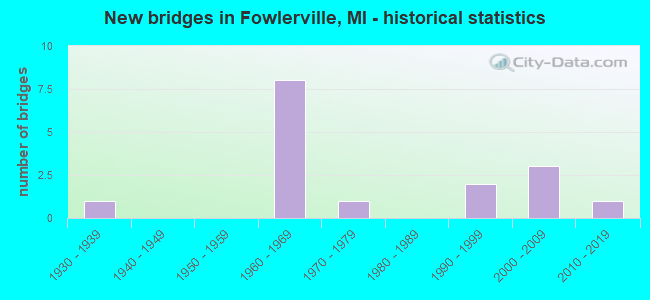
- New bridges - historical statistics
- 11930-1939
- 81960-1969
- 11970-1979
- 21990-1999
- 32000-2009
- 12010-2019


- Bridge Condition - Deck
- 7.1%Very good
- 21.4%Good
- 42.9%Satisfactory
- 21.4%Fair
- 7.1%Poor

- Bridge Condition - Superstructure
- 21.4%Very good
- 28.6%Good
- 14.3%Satisfactory
- 21.4%Fair
- 14.3%Poor

- Bridge Condition - Substructure
- 7.1%Excellent
- 14.3%Very good
- 42.9%Good
- 28.6%Satisfactory
- 7.1%Fair

- Bridge Condition - Channel
- 16.7%Very good
- 50.0%Good
- 25.0%Satisfactory
- 8.3%Serious
Find on map >> Show street view
Structure Number: 5793, Location: 3.4 MI E OF INGHAM COL (Lat: 42.646019, Lng: -84.082186), Route carried "on" structure: Interstate 96, Year Built: 1961, Status: Open, Structure Length: 1.22m (4.00ft), Average Daily Traffic: 24,250 (year 2013), Truck Traffic: 10%, Average Future Daily Traffic: 26,775 (year 2033), Design Load: HS 20+Mod, Features Intersected: MIDDLE BR RED CEDAR
Minimum Vertical Clearance: 30.48m (100.00ft), Kilometerpoint: 5.504, Lanes on structure: 2, Base Highway Network: Yes (Inventory Route: 93, Subroute: 5), Owner: State Highway Agency, Approaching Roadway Width: 13.4m (44.0ft), Material/Design: Prestressed concrete, Design/Construction: Stringer/Multi-beam, Number Of Spans In Main Unit: 1, Length of Maximum Span: 11.0m (36.1ft), Curb-To-Curb Width: 11.7m (38.4ft), Out-to-Out Width: 13.3m (43.6ft)
Condition: Deck: Satisfactory, Superstructure: Good, Substructure: Good, Channel: Satisfactory, Operating Rating: 72.6 metric tons, Method Used To Determine Operating Rating: Load Factor (LF), Inventory Rating: 43.5 metric tons, Method Used To Determine Inventory Rating: Load Factor (LF), Structural Evaluation: Better than present minimum criteria, Deck Geometry: Equal to present minimum criteria, Waterway Adequacy: Equal to present desirable criteria, Approach Roadway Alignment: Equal to present desirable criteria, Designated Inspection Frequency: Every 24 months, Inspection Date: September 2021, Deck Structure Type: Concrete Cast-file-Place, Wearing Surface/Protective System: Wearing Surface: Bituminous
Find on map >> Show street view
Structure Number: 5794, Location: 3.4 MI E OF INGHAM COL (Lat: 42.646581, Lng: -84.082181), Route carried "on" structure: Interstate 96, Year Built: 1961, Status: Open, Structure Length: 1.22m (4.00ft), Average Daily Traffic: 24,250 (year 2013), Truck Traffic: 10%, Average Future Daily Traffic: 26,775 (year 2033), Design Load: HS 20+Mod, Features Intersected: MIDDLE BR RED CEDAR
Minimum Vertical Clearance: 30.48m (100.00ft), Kilometerpoint: 5.506, Lanes on structure: 2, Base Highway Network: Yes (Inventory Route: 93, Subroute: 7), Owner: State Highway Agency, Approaching Roadway Width: 13.4m (44.0ft), Material/Design: Prestressed concrete, Design/Construction: Stringer/Multi-beam, Number Of Spans In Main Unit: 1, Length of Maximum Span: 11.0m (36.1ft), Curb-To-Curb Width: 11.7m (38.4ft), Out-to-Out Width: 13.3m (43.6ft)
Condition: Deck: Satisfactory, Superstructure: Good, Substructure: Good, Channel: Satisfactory, Operating Rating: 76.8 metric tons, Method Used To Determine Operating Rating: Load Factor (LF), Inventory Rating: 46.0 metric tons, Method Used To Determine Inventory Rating: Load Factor (LF), Structural Evaluation: Better than present minimum criteria, Deck Geometry: Equal to present minimum criteria, Waterway Adequacy: Equal to present desirable criteria, Approach Roadway Alignment: Equal to present desirable criteria, Designated Inspection Frequency: Every 24 months, Inspection Date: May 2021, Deck Structure Type: Concrete Cast-file-Place, Wearing Surface/Protective System: Wearing Surface: Latex Concrete
Find on map >> Show street view
Structure Number: 5795, Location: 2.0 MI E OF INGHAM COL (Lat: 42.649825, Lng: -84.112117), Route carried "on" structure: County highway , Year Built: 1962, Status: Open, Structure Length: 7.16m (23.49ft), Average Daily Traffic: 750 (year 1974), Truck Traffic: 3%, Average Future Daily Traffic: 750 (year 1977), Design Load: H 15, Features Intersected: I-96, Facility Carried by Structure: NICHOLSON RD
Minimum Vertical Clearance: 30.48m (100.00ft), Kilometerpoint: 5.606, Lanes on structure: 2, Lanes under structure: 4, Owner: State Highway Agency, Approaching Roadway Width: 12.2m (40.0ft), Skew: 2 degrees, Material/Design: Steel, Design/Construction: Stringer/Multi-beam, Number Of Spans In Main Unit: 4, Length of Maximum Span: 23.4m (76.8ft), Curb-To-Curb Width: 8.5m (27.9ft), Out-to-Out Width: 9.4m (30.8ft)
Condition: Deck: Fair, Superstructure: Fair, Substructure: Satisfactory, Operating Rating: 59.0 metric tons, Method Used To Determine Operating Rating: Load Factor (LF) rating reported by rating factor (RF) method using MS18 loading, Inventory Rating: 35.6 metric tons, Method Used To Determine Inventory Rating: Load Factor (LF) rating reported by rating factor (RF) method using MS18 loading, Structural Evaluation: Somewhat better than minimum adequacy, Deck Geometry: Somewhat better than minimum adequacy, Underclear: High priority of corrective action, Approach Roadway Alignment: Equal to present desirable criteria, Designated Inspection Frequency: Every 24 months, Inspection Date: September 2021, Bridge Improvement Cost: $26,000, Deck Structure Type: Concrete Cast-file-Place, Wearing Surface/Protective System: Wearing Surface: Epoxy Overlay
Find on map >> Show street view
Structure Number: 5796, Location: 4.0 MI E OF INGHAM CO LIN (Lat: 42.646294, Lng: -84.072517), Route carried "on" structure: County highway 4715, Year Built: 1962, Status: Open, Structure Length: 7.28m (23.88ft), Average Daily Traffic: 1,400 (year 1974), Average Future Daily Traffic: 1,400 (year 1977), Design Load: H 15, Features Intersected: I-96, Facility Carried by Structure: FOWLERVILLE RD
Minimum Vertical Clearance: 30.48m (100.00ft), Kilometerpoint: 5.216, Lanes on structure: 2, Lanes under structure: 6, Owner: State Highway Agency, Approaching Roadway Width: 12.2m (40.0ft), Material/Design: Steel, Design/Construction: Stringer/Multi-beam, Number Of Spans In Main Unit: 4, Length of Maximum Span: 25.0m (82.0ft), Curb-To-Curb Width: 9.1m (29.9ft), Out-to-Out Width: 10.0m (32.8ft)
Condition: Deck: Fair, Superstructure: Fair, Substructure: Satisfactory, Operating Rating: 50.2 metric tons, Method Used To Determine Operating Rating: Load Factor (LF), Inventory Rating: 30.1 metric tons, Method Used To Determine Inventory Rating: Load Factor (LF), Structural Evaluation: Somewhat better than minimum adequacy, Deck Geometry: Somewhat better than minimum adequacy, Underclear: Meets minimum limits, Approach Roadway Alignment: Equal to present desirable criteria, Designated Inspection Frequency: Every 24 months, Other Special Inspection Frequency: Every 12 months, Inspection Date: September 2021, Other Special Inspection Date: September 2021, Deck Structure Type: Concrete Cast-file-Place, Wearing Surface/Protective System: Wearing Surface: Latex Concrete
Find on map >> Show street view
Structure Number: 5814, Location: SEC 3 IOSCO TWP (Lat: 42.599317, Lng: -84.074517), Route carried "on" structure: County highway 4750, Year Built: 1990, Status: Posted for load, Structure Length: 1.09m (3.58ft), Average Daily Traffic: 5,110 (year 2020), Truck Traffic: 3%, Average Future Daily Traffic: 6,132 (year 2039), Design Load: HS 20, Features Intersected: RED CEDAR RIVER IMP. DRN, Facility Carried by Structure: MASON ROAD
Minimum Vertical Clearance: 30.48m (100.00ft), Kilometerpoint: 5.768, Lanes on structure: 2, Owner: County Highway Agency, Approaching Roadway Width: 13.4m (44.0ft), Material/Design: Prestressed concrete, Design/Construction: Tee Beam, Number Of Spans In Main Unit: 1, Length of Maximum Span: 9.7m (31.8ft), Curb-To-Curb Width: 13.4m (44.0ft), Out-to-Out Width: 14.1m (46.3ft)
Condition: Deck: Poor, Superstructure: Poor, Substructure: Good, Channel: Very good, Operating Rating: 44.1 metric tons, Method Used To Determine Operating Rating: Load Factor (LF) rating reported by rating factor (RF) method using MS18 loading, Inventory Rating: 26.2 metric tons, Method Used To Determine Inventory Rating: Load Factor (LF) rating reported by rating factor (RF) method using MS18 loading, Structural Evaluation: Meets minimum limits, Deck Geometry: Equal to present minimum criteria, Waterway Adequacy: Equal to present desirable criteria, Approach Roadway Alignment: Equal to present desirable criteria, Bridge Posting: Required (Relationship of Operating Rating to Maximum Legal Load: 10.0 - 19.9% below), Designated Inspection Frequency: Every 24 months, Inspection Date: August 2021, Deck Structure Type: Concrete Cast-file-Place, Wearing Surface/Protective System: Wearing Surface: Bituminous
Find on map >> Show street view
Structure Number: 5828, Location: SEC 4-5 HANDY TWP (Lat: 42.683478, Lng: -84.113558), Route carried "on" structure: County highway , Year Built: 1970, Status: Open, Structure Length: 1.58m (5.18ft), Average Daily Traffic: 880 (year 2015), Average Future Daily Traffic: 980 (year 2035), Design Load: HS 20+Mod, Features Intersected: RED CEDAR RIVER, Facility Carried by Structure: NICHOLSON ROAD
Minimum Vertical Clearance: 30+ m (98+ ft), Kilometerpoint: 9.344, Lanes on structure: 2, Owner: County Highway Agency, Approaching Roadway Width: 10.4m (34.1ft), Material/Design: Prestressed concrete, Design/Construction: Box Beam or Girders - Multiple, Number Of Spans In Main Unit: 1, Length of Maximum Span: 15.2m (49.9ft), Curb-To-Curb Width: 10.1m (33.1ft), Out-to-Out Width: 10.1m (33.1ft)
Condition: Deck: Fair, Superstructure: Very good, Substructure: Very good, Channel: Good, Operating Rating: 54.6 metric tons, Method Used To Determine Operating Rating: Field evaluation and documented engineering judgment, Inventory Rating: 32.7 metric tons, Method Used To Determine Inventory Rating: Field evaluation and documented engineering judgment, Structural Evaluation: Equal to present desirable criteria, Deck Geometry: Equal to present minimum criteria, Waterway Adequacy: Equal to present desirable criteria, Approach Roadway Alignment: Equal to present desirable criteria, Designated Inspection Frequency: Every 24 months, Inspection Date: August 2020, Deck Structure Type: Concrete Precast Panels, Wearing Surface/Protective System: Wearing Surface: Bituminous
Find on map >> Show street view
Structure Number: 5831, Location: SEC 22-23 HANDY TWP (Lat: 42.641736, Lng: -84.072364), Route carried "on" structure: County highway 4715, Year Built: 1961, Status: Open, Structure Length: 1.22m (4.00ft), Average Daily Traffic: 4,150 (year 2019), Average Future Daily Traffic: 4,980 (year 2039), Design Load: HS 20+Mod, Features Intersected: RED CEDAR RIVER, Facility Carried by Structure: FOWLERVILLE ROAD
Minimum Vertical Clearance: 30.48m (100.00ft), Kilometerpoint: 4.709, Lanes on structure: 2, Owner: County Highway Agency, Approaching Roadway Width: 8.5m (27.9ft), Material/Design: Prestressed concrete, Design/Construction: Box Beam or Girders - Multiple, Number Of Spans In Main Unit: 1, Length of Maximum Span: 11.2m (36.7ft), Curb-To-Curb Width: 8.8m (28.9ft), Out-to-Out Width: 10.5m (34.4ft)
Condition: Deck: Satisfactory, Superstructure: Fair, Substructure: Satisfactory, Channel: Satisfactory, Operating Rating: 64.5 metric tons, Method Used To Determine Operating Rating: Load Factor (LF) rating reported by rating factor (RF) method using MS18 loading, Inventory Rating: 38.6 metric tons, Method Used To Determine Inventory Rating: Load Factor (LF) rating reported by rating factor (RF) method using MS18 loading, Structural Evaluation: Somewhat better than minimum adequacy, Deck Geometry: Meets minimum limits, Waterway Adequacy: Equal to present desirable criteria, Approach Roadway Alignment: Equal to present desirable criteria, Designated Inspection Frequency: Every 24 months, Inspection Date: August 2021, Deck Structure Type: Other, Wearing Surface/Protective System: Wearing Surface: Bituminous
Find on map >> Show street view
Structure Number: 5868, Location: SEC 15-22 HANDY TWP (Lat: 42.642983, Lng: -84.081072), Route carried "on" structure: ServiceCounty highway , Year Built: 1967, Status: Posted for load, Structure Length: 0.80m (2.62ft), Average Daily Traffic: 3,380 (year 2015), Average Future Daily Traffic: 3,755 (year 2035), Design Load: H 20, Features Intersected: RED CEDAR RIVER IMP. DRN, Facility Carried by Structure: VAN BUREN ROAD
Minimum Vertical Clearance: 30+ m (98+ ft), Kilometerpoint: 4.440, Lanes on structure: 2, Owner: County Highway Agency, Approaching Roadway Width: 9.1m (29.9ft), Material/Design: Wood or Timber, Design/Construction: Slab, Number Of Spans In Main Unit: 1, Length of Maximum Span: 7.3m (24.0ft), Curb or Sidewalk Widths: Left: 0.2m (0.7ft), Right: 0.2m (0.7ft), Curb-To-Curb Width: 9.4m (30.8ft), Out-to-Out Width: 9.8m (32.2ft)
Condition: Deck: Satisfactory, Superstructure: Satisfactory, Substructure: Satisfactory, Channel: Good, Operating Rating: 57.7 metric tons, Method Used To Determine Operating Rating: Allowable Stress (AS) rating reported by rating factor (RF) method using MS18 loading, Inventory Rating: 40.8 metric tons, Method Used To Determine Inventory Rating: Allowable Stress (AS) rating reported by rating factor (RF) method using MS18 loading, Structural Evaluation: Equal to present minimum criteria, Deck Geometry: Meets minimum limits, Waterway Adequacy: Better than present minimum criteria, Approach Roadway Alignment: Equal to present desirable criteria, Bridge Posting: Required (Relationship of Operating Rating to Maximum Legal Load: > 39.9% below), Designated Inspection Frequency: Every 24 months, Inspection Date: August 2020, Deck Structure Type: Wood or Timber, Wearing Surface/Protective System: Wearing Surface: Bituminous
Find on map >> Show street view
Structure Number: 587, Location: SEC 3-4 HANDY TWP (Lat: 42.676978, Lng: -84.093900), Route carried "on" structure: County highway , Year Built: 2005, Status: Open, Structure Length: 1.37m (4.49ft), Average Daily Traffic: 305 (year 2014), Average Future Daily Traffic: 340 (year 2034), Design Load: HS 20, Features Intersected: RED CEDAR RIVER IMP DRN, Facility Carried by Structure: GREGORY ROAD
Minimum Vertical Clearance: 30+ m (98+ ft), Kilometerpoint: 3.330, Lanes on structure: 2, Owner: County Highway Agency, Approaching Roadway Width: 9.1m (29.9ft), Skew: 2 degrees, Material/Design: Prestressed concrete, Design/Construction: Box Beam or Girders - Multiple, Number Of Spans In Main Unit: 1, Length of Maximum Span: 12.5m (41.0ft), Curb-To-Curb Width: 9.8m (32.2ft), Out-to-Out Width: 10.4m (34.1ft)
Condition: Deck: Satisfactory, Superstructure: Very good, Substructure: Very good, Channel: Good, Operating Rating: 59.9 metric tons, Method Used To Determine Operating Rating: Load Factor (LF), Inventory Rating: 35.8 metric tons, Method Used To Determine Inventory Rating: Load Factor (LF), Structural Evaluation: Equal to present desirable criteria, Deck Geometry: Better than present minimum criteria, Waterway Adequacy: Equal to present minimum criteria, Approach Roadway Alignment: Meets minimum limits, Designated Inspection Frequency: Every 24 months, Inspection Date: August 2020, Deck Structure Type: Concrete Cast-file-Place, Wearing Surface/Protective System: Wearing Surface: Bituminous
Find on map >> Show street view
Structure Number: 5871, Location: SEC 13-14 HANDY TWP (Lat: 42.644775, Lng: -84.052956), Route carried "on" structure: County highway , Year Built: 1999, Status: Open, Structure Length: 1.07m (3.51ft), Average Daily Traffic: 160 (year 2019), Average Future Daily Traffic: 200 (year 2039), Design Load: HS 20+Mod, Features Intersected: RED CEDAR RIVER, Facility Carried by Structure: SMITH ROAD
Minimum Vertical Clearance: 30.48m (100.00ft), Kilometerpoint: 5.045, Lanes on structure: 1, Owner: County Highway Agency, Approaching Roadway Width: 5.5m (18.0ft), Skew: 1 degrees, Material/Design: Wood or Timber, Design/Construction: Slab, Number Of Spans In Main Unit: 1, Length of Maximum Span: 10.0m (32.8ft), Curb-To-Curb Width: 4.3m (14.1ft), Out-to-Out Width: 5.0m (16.4ft)
Condition: Deck: Good, Superstructure: Good, Substructure: Good, Channel: Good, Operating Rating: 60.9 metric tons, Method Used To Determine Operating Rating: Allowable Stress (AS) rating reported by rating factor (RF) method using MS18 loading, Inventory Rating: 42.1 metric tons, Method Used To Determine Inventory Rating: Allowable Stress (AS) rating reported by rating factor (RF) method using MS18 loading, Structural Evaluation: Better than present minimum criteria, Deck Geometry: High priority of replacement, Waterway Adequacy: Equal to present minimum criteria, Approach Roadway Alignment: Meets minimum limits, Designated Inspection Frequency: Every 24 months, Inspection Date: August 2021, Deck Structure Type: Wood or Timber, Wearing Surface/Protective System: Wearing Surface: Bituminous, Deck Protection: Epoxy Coated Reinforcing
Find on map >> Show street view
Structure Number: 5875, Location: SEC 30 HOWELL TWP (Lat: 42.621444, Lng: -84.017189), Route carried "on" structure: ServiceCounty highway , Year Built: 1933, Status: Posted for load, Structure Length: 0.73m (2.40ft), Average Daily Traffic: 142 (year 2013), Average Future Daily Traffic: 200 (year 2021), Design Load: HS 20+Mod, Features Intersected: RED CEDAR RIVER, Facility Carried by Structure: MILLET ROAD
Minimum Vertical Clearance: 30.48m (100.00ft), Kilometerpoint: 1.236, Lanes on structure: 2, Owner: County Highway Agency, Approaching Roadway Width: 6.1m (20.0ft), Material/Design: Steel, Design/Construction: Stringer/Multi-beam, Number Of Spans In Main Unit: 1, Length of Maximum Span: 6.7m (22.0ft), Curb-To-Curb Width: 6.4m (21.0ft), Out-to-Out Width: 6.7m (22.0ft)
Condition: Deck: Good, Superstructure: Poor, Substructure: Fair, Channel: Serious, Operating Rating: 30.8 metric tons, Method Used To Determine Operating Rating: Load Factor (LF) rating reported by rating factor (RF) method using MS18 loading, Inventory Rating: 18.5 metric tons, Method Used To Determine Inventory Rating: Load Factor (LF) rating reported by rating factor (RF) method using MS18 loading, Structural Evaluation: Meets minimum limits, Deck Geometry: Meets minimum limits, Waterway Adequacy: Equal to present minimum criteria, Approach Roadway Alignment: Equal to present desirable criteria, Bridge Posting: Required (Relationship of Operating Rating to Maximum Legal Load: 20.0 - 29.9% below), Designated Inspection Frequency: Every 24 months, Inspection Date: June 2020, Deck Structure Type: Concrete Cast-file-Place, Wearing Surface/Protective System: Wearing Surface: Monolithic Concrete
Find on map >> Show street view
Structure Number: 5877, Location: SEC 19 HOWELL TWP (Lat: 42.635806, Lng: -84.032628), Route carried "on" structure: ServiceCounty highway , Year Built: 2013, Status: Open, Structure Length: 1.16m (3.81ft), Average Daily Traffic: 223 (year 2012), Average Future Daily Traffic: 365 (year 2032), Design Load: Greater than HL93, Features Intersected: E BR RED CEDAR RIVER DRN, Facility Carried by Structure: LAYTON ROAD
Minimum Vertical Clearance: 30.48m (100.00ft), Kilometerpoint: 3.238, Lanes on structure: 2, Owner: County Highway Agency, Approaching Roadway Width: 8.5m (27.9ft), Material/Design: Prestressed concrete, Design/Construction: Box Beam or Girders - Multiple, Number Of Spans In Main Unit: 1, Length of Maximum Span: 11.2m (36.7ft), Curb or Sidewalk Widths: Left: 0.5m (1.6ft), Right: 0.5m (1.6ft), Curb-To-Curb Width: 8.7m (28.5ft), Out-to-Out Width: 9.8m (32.2ft)
Condition: Deck: Very good, Superstructure: Very good, Substructure: Excellent, Channel: Very good, Operating Rating: 56.7 metric tons, Method Used To Determine Operating Rating: Load and Resistance Factor Rating (LRFR) rating reported by rating factor(RF) method using HL-93 loadings, Inventory Rating: 43.7 metric tons, Method Used To Determine Inventory Rating: Load and Resistance Factor Rating (LRFR) rating reported by rating factor(RF) method using HL-93 loadings, Structural Evaluation: Equal to present desirable criteria, Deck Geometry: Equal to present minimum criteria, Waterway Adequacy: Somewhat better than minimum adequacy, Approach Roadway Alignment: Equal to present minimum criteria, Designated Inspection Frequency: Every 24 months, Inspection Date: August 2021, Deck Structure Type: Concrete Cast-file-Place, Wearing Surface/Protective System: Wearing Surface: Monolithic Concrete, Deck Protection: Epoxy Coated Reinforcing
Find on map >> Show street view
Structure Number: 5896, Location: IN FOWLERVILLE (Lat: 42.660675, Lng: -84.080647), Route carried "on" structure: City street , Year Built: 2001, Status: Open, Structure Length: 1.60m (5.25ft), Average Daily Traffic: 7,870 (year 1998), Truck Traffic: 3%, Average Future Daily Traffic: 13,000 (year 2018), Design Load: HS 20, Features Intersected: RED CEDAR RIVER, Facility Carried by Structure: GRAND RIVER ST
Minimum Vertical Clearance: 30.48m (100.00ft), Kilometerpoint: 5.733, Lanes on structure: 3, Base Highway Network: Yes (Inventory Route: 93, Subroute: 10), Owner: City or Municipal Highway Agency, Approaching Roadway Width: 11.9m (39.0ft), Skew: 1 degrees, Material/Design: Prestressed concrete, Design/Construction: Box Beam or Girders - Multiple, Number Of Spans In Main Unit: 1, Length of Maximum Span: 14.8m (48.6ft), Curb or Sidewalk Widths: Left: 2.0m (6.6ft), Right: 2.0m (6.6ft), Curb-To-Curb Width: 12.5m (41.0ft), Out-to-Out Width: 17.1m (56.1ft)
Condition: Deck: Good, Superstructure: Good, Substructure: Good, Channel: Good, Operating Rating: 88.1 metric tons, Method Used To Determine Operating Rating: Load Factor (LF) rating reported by rating factor (RF) method using MS18 loading, Inventory Rating: 38.2 metric tons, Method Used To Determine Inventory Rating: Load Factor (LF) rating reported by rating factor (RF) method using MS18 loading, Structural Evaluation: Better than present minimum criteria, Deck Geometry: Meets minimum limits, Waterway Adequacy: Equal to present desirable criteria, Approach Roadway Alignment: Equal to present desirable criteria, Designated Inspection Frequency: Every 24 months, Inspection Date: July 2020, Deck Structure Type: Concrete Cast-file-Place, Wearing Surface/Protective System: Wearing Surface: Monolithic Concrete, Deck Protection: Epoxy Coated Reinforcing
Find on map >> Show street view
Structure Number: 13471, Location: 0.2 MI W OF GRAND RIVER A (Lat: 42.655278, Lng: -84.079722), Route carried "on" structure: City street , Year Built: 2001, Status: Open, Structure Length: 2.94m (9.65ft), Average Daily Traffic: 1,000 (year 1998), Truck Traffic: 20%, Average Future Daily Traffic: 3,500 (year 2018), Design Load: HS 20, Features Intersected: RED CEDAR RIVER, Facility Carried by Structure: GARDEN LANE
Minimum Vertical Clearance: 30.48m (100.00ft), Kilometerpoint: 1.073, Lanes on structure: 2, Owner: City or Municipal Highway Agency, Approaching Roadway Width: 11.0m (36.1ft), Skew: 3 degrees, Material/Design: Prestressed concrete, Design/Construction: Box Beam or Girders - Multiple, Number Of Spans In Main Unit: 1, Length of Maximum Span: 28.2m (92.5ft), Curb or Sidewalk Widths: Left: 0.8m (2.6ft), Right: 0.8m (2.6ft), Curb-To-Curb Width: 11.0m (36.1ft), Out-to-Out Width: 12.5m (41.0ft)
Condition: Deck: Satisfactory, Superstructure: Satisfactory, Substructure: Good, Channel: Good, Operating Rating: 87.5 metric tons, Method Used To Determine Operating Rating: Load Factor (LF) rating reported by rating factor (RF) method using MS18 loading, Inventory Rating: 39.2 metric tons, Method Used To Determine Inventory Rating: Load Factor (LF) rating reported by rating factor (RF) method using MS18 loading, Structural Evaluation: Equal to present minimum criteria, Deck Geometry: Better than present minimum criteria, Waterway Adequacy: Equal to present desirable criteria, Approach Roadway Alignment: Equal to present minimum criteria, Designated Inspection Frequency: Every 24 months, Inspection Date: July 2020, Deck Structure Type: Concrete Cast-file-Place, Wearing Surface/Protective System: Wearing Surface: Monolithic Concrete, Deck Protection: Epoxy Coated Reinforcing
Find on map >> Show street view
Structure Number: 5795, Location: 2.0 MI E OF INGHAM COL (Lat: 42.649825, Lng: -84.112117), Route carried "under" structure: Interstate 96, Year Built: 1962, Structure Length: 0. m, Average Daily Traffic: 48,560 (year 2007), Truck Traffic: 11%, Features Intersected: I-96, Facility Carried by Structure: NICHOLSON RD
Minimum Vertical Clearance: 4.98m (16.34ft), Kilometerpoint: 2.973, Lanes on structure: 2, Lanes under structure: 4, Material/Design: Steel, Design/Construction: Stringer/Multi-beam, Length of Maximum Span: 23.4m (76.8ft)
Find on map >> Show street view
Structure Number: 5796, Location: 4.0 MI E OF INGHAM CO LIN (Lat: 42.646294, Lng: -84.072517), Route carried "under" structure: Interstate 96, Year Built: 1962, Structure Length: 0. m, Average Daily Traffic: 53,414 (year 2007), Truck Traffic: 11%, Features Intersected: I-96, Facility Carried by Structure: FOWLERVILLE RD
Minimum Vertical Clearance: 5.00m (16.40ft), Kilometerpoint: 6.298, Lanes on structure: 2, Lanes under structure: 6, Material/Design: Steel, Design/Construction: Stringer/Multi-beam, Length of Maximum Span: 25.0m (82.0ft)