Bridge Statistics for Fowler, New York (NY)
Condition, Traffic, Stress, Structural Evaluation, Project Costs
- National Bridge Inventory (NBI) Statistics
- 20Number of bridges
- 161ft / 48.6mTotal length
- $19,567,000Total costs
- 19,774Total average daily traffic
- 1,376Total average daily truck traffic
- National Bridge Inventory (NBI) Registered Bridges for Fowler
- No street view available for this location
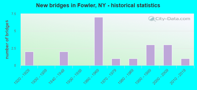
- New bridges - historical statistics
- 21920-1929
- 21940-1949
- 71960-1969
- 11970-1979
- 11980-1989
- 31990-1999
- 32000-2009
- 12010-2019

- Reconstructed bridges - Historical Statistics
- 11990-1999
- 12000-2009
- 12010-2019


- Bridge Condition - Deck
- 17.6%Excellent
- 17.6%Very good
- 17.6%Good
- 17.6%Satisfactory
- 23.5%Fair
- 5.9%Serious

- Bridge Condition - Superstructure
- 17.6%Excellent
- 29.4%Very good
- 23.5%Good
- 17.6%Satisfactory
- 5.9%Fair
- 5.9%Critical

- Bridge Condition - Substructure
- 11.8%Excellent
- 29.4%Very good
- 29.4%Good
- 23.5%Fair
- 5.9%Poor

- Bridge Condition - Channel
- 47.4%Very good
- 36.8%Good
- 5.3%Satisfactory
- 10.5%Fair

- Bridge Condition - Culverts
- 50.0%Good
- 50.0%Satisfactory
Find on map >> Show street view
Structure Number: 102751, Location: 1.2 MI SE JCT RTS 58 + 11 (Lat: 44.312792, Lng: -75.455631), Route carried "on" structure: State highway 58, Year Built: 1968, Status: Open, Structure Length: 4.94m (16.21ft), Average Daily Traffic: 4,490 (year 2020), Truck Traffic: 9%, Average Future Daily Traffic: 4,532 (year 2040), Design Load: H 20, Features Intersected: MATOON CREEK
Minimum Vertical Clearance: 30+ m (98+ ft), Kilometerpoint: 33.178, Lanes on structure: 2, Base Highway Network: Yes, Owner: State Highway Agency, Approaching Roadway Width: 12.8m (42.0ft), Skew: 2 degrees, Material/Design: Steel, Design/Construction: Stringer/Multi-beam, Number Of Spans In Main Unit: 1, Length of Maximum Span: 47.5m (155.8ft), Curb-To-Curb Width: 13.1m (43.0ft), Out-to-Out Width: 14.0m (45.9ft)
Condition: Deck: Satisfactory, Superstructure: Very good, Substructure: Good, Channel: Very good, Operating Rating: 65.8 metric tons, Method Used To Determine Operating Rating: Load and Resistance Factor Rating (LRFR) rating reported by rating factor(RF) method using HL-93 loadings, Inventory Rating: 50.9 metric tons, Method Used To Determine Inventory Rating: Load and Resistance Factor Rating (LRFR) rating reported by rating factor(RF) method using HL-93 loadings, Structural Evaluation: Better than present minimum criteria, Deck Geometry: Equal to present minimum criteria, Waterway Adequacy: Equal to present minimum criteria, Approach Roadway Alignment: Equal to present desirable criteria, Length Of Structure Improvement: 4.93m (16.17ft), Designated Inspection Frequency: Every 24 months, Inspection Date: July 2021, Bridge Improvement Cost: $1,580,000, Roadway Improvement Cost: $925,000, Total Project Cost: $2,504,000 ( Estimate for 2021), Deck Structure Type: Concrete Cast-file-Place, Wearing Surface/Protective System: Wearing Surface: Monolithic Concrete
Find on map >> Show street view
Structure Number: 102753, Location: 7.3 MI SE JCT RTS 58 + 11 (Lat: 44.278897, Lng: -75.355028), Route carried "on" structure: State highway 58, Year Built: 2001, Status: Open, Structure Length: 4.60m (15.09ft), Average Daily Traffic: 1,793 (year 2020), Truck Traffic: 7%, Average Future Daily Traffic: 2,510 (year 2040), Design Load: HS 25 or greater, Features Intersected: W B OSWEGATCHIE R
Minimum Vertical Clearance: 30+ m (98+ ft), Kilometerpoint: 23.443, Lanes on structure: 2, Base Highway Network: Yes, Owner: State Highway Agency, Approaching Roadway Width: 11.6m (38.1ft), Material/Design: Steel, Design/Construction: Stringer/Multi-beam, Number Of Spans In Main Unit: 1, Length of Maximum Span: 44.7m (146.7ft), Curb-To-Curb Width: 11.5m (37.7ft), Out-to-Out Width: 12.5m (41.0ft)
Condition: Deck: Good, Superstructure: Very good, Substructure: Excellent, Channel: Good, Operating Rating: 73.5 metric tons, Method Used To Determine Operating Rating: Load Factor (LF), Inventory Rating: 43.5 metric tons, Method Used To Determine Inventory Rating: Load Factor (LF), Structural Evaluation: Equal to present desirable criteria, Deck Geometry: Equal to present minimum criteria, Waterway Adequacy: Equal to present minimum criteria, Approach Roadway Alignment: Equal to present desirable criteria, Length Of Structure Improvement: 4.60m (15.09ft), Designated Inspection Frequency: Every 24 months, Inspection Date: September 2021, Bridge Improvement Cost: $1,348,000, Roadway Improvement Cost: $790,000, Total Project Cost: $2,138,000 ( Estimate for 2021), Deck Structure Type: Concrete Cast-file-Place, Wearing Surface/Protective System: Wearing Surface: Integral Concrete, Deck Protection: Epoxy Coated Reinforcing
Find on map >> Show street view
Structure Number: 10463, Location: 2.5MI E. JCT RTS 352 & 17 (Lat: 42.132567, Lng: -76.937203), Route carried "on" structure: Alternate State highway 352, Year Built: 1992, Status: Open, Structure Length: 1.89m (6.20ft), Average Daily Traffic: 5,275 (year 2018), Truck Traffic: 4%, Average Future Daily Traffic: 5,299 (year 2040), Design Load: HS 20, Features Intersected: GARDINER CREEK
Minimum Vertical Clearance: 30+ m (98+ ft), Kilometerpoint: 2.510, Lanes on structure: 2, Base Highway Network: Yes, Owner: State Highway Agency, Approaching Roadway Width: 11.0m (36.1ft), Skew: 2 degrees, Material/Design: Prestressed concrete, Design/Construction: Box Beam or Girders - Multiple, Number Of Spans In Main Unit: 1, Length of Maximum Span: 17.6m (57.7ft), Curb-To-Curb Width: 11.0m (36.1ft), Out-to-Out Width: 11.7m (38.4ft)
Condition: Deck: Satisfactory, Superstructure: Satisfactory, Substructure: Very good, Channel: Good, Operating Rating: 89.8 metric tons, Method Used To Determine Operating Rating: Load Factor (LF), Inventory Rating: 32.7 metric tons, Method Used To Determine Inventory Rating: Load Factor (LF), Structural Evaluation: Equal to present minimum criteria, Deck Geometry: Meets minimum limits, Waterway Adequacy: Meets minimum limits, Approach Roadway Alignment: Equal to present desirable criteria, Length Of Structure Improvement: 1.88m (6.17ft), Designated Inspection Frequency: Every 24 months, Inspection Date: May 2020, Bridge Improvement Cost: $563,000, Roadway Improvement Cost: $330,000, Total Project Cost: $892,000 ( Estimate for 2021), Deck Structure Type: Concrete Cast-file-Place, Wearing Surface/Protective System: Wearing Surface: Integral Concrete
Find on map >> Show street view
Structure Number: 10469, Location: 2.7 MI NE OF COHOCTON (Lat: 42.532011, Lng: -77.466028), Route carried "on" structure: State highway 371, Year Built: 1946, Status: Open, Structure Length: 1.28m (4.20ft), Average Daily Traffic: 2,308 (year 2017), Truck Traffic: 18%, Average Future Daily Traffic: 2,407 (year 2040), Design Load: H 20, Features Intersected: KIRKWOOD CREEK
Minimum Vertical Clearance: 30+ m (98+ ft), Kilometerpoint: 4.376, Lanes on structure: 2, Base Highway Network: Yes, Owner: State Highway Agency, Approaching Roadway Width: 9.8m (32.2ft), Skew: 3 degrees, Material/Design: Steel, Design/Construction: Stringer/Multi-beam, Number Of Spans In Main Unit: 1, Length of Maximum Span: 11.8m (38.7ft), Curb-To-Curb Width: 10.1m (33.1ft), Out-to-Out Width: 10.8m (35.4ft)
Condition: Deck: Fair, Superstructure: Satisfactory, Substructure: Fair, Channel: Satisfactory, Operating Rating: 49.0 metric tons, Method Used To Determine Operating Rating: Load Factor (LF), Inventory Rating: 29.0 metric tons, Method Used To Determine Inventory Rating: Load Factor (LF), Structural Evaluation: Somewhat better than minimum adequacy, Deck Geometry: Meets minimum limits, Waterway Adequacy: Meets minimum limits, Approach Roadway Alignment: Equal to present desirable criteria, Length Of Structure Improvement: 1.28m (4.20ft), Designated Inspection Frequency: Every 24 months, Inspection Date: July 2021, Bridge Improvement Cost: $657,000, Roadway Improvement Cost: $384,000, Total Project Cost: $1,041,000 ( Estimate for 2021), Deck Structure Type: Concrete Cast-file-Place, Wearing Surface/Protective System: Wearing Surface: Bituminous, Membrane: Other
Find on map >> Show street view
Structure Number: 222122, Location: 1 MILE SE OF GOVERNEUR (Lat: 44.313831, Lng: -75.450658), Route carried "on" structure: Other road , Year Built: 1962, Status: Open, Structure Length: 1.16m (3.81ft), Average Daily Traffic: 783 (year 2018), Truck Traffic: 3%, Average Future Daily Traffic: 1,096 (year 2038), Features Intersected: W IS BR OSWEGACHI, Facility Carried by Structure: RIVER ROAD
Minimum Vertical Clearance: 30+ m (98+ ft), Kilometerpoint: 0.113, Lanes on structure: 2, Owner: Town or Township Highway Agency, Approaching Roadway Width: 9.4m (30.8ft), Skew: 2 degrees, Material/Design: Steel, Design/Construction: Culvert, Number Of Spans In Main Unit: 3, Length of Maximum Span: 3.6m (11.8ft)
Condition: Channel: Fair, Culverts: Satisfactory, Operating Rating: 74.1 metric tons, Method Used To Determine Operating Rating: Field evaluation and documented engineering judgment, Inventory Rating: 19.6 metric tons, Method Used To Determine Inventory Rating: Field evaluation and documented engineering judgment, Structural Evaluation: Somewhat better than minimum adequacy, Waterway Adequacy: Meets minimum limits, Approach Roadway Alignment: Better than present minimum criteria, Length Of Structure Improvement: 1.15m (3.77ft), Designated Inspection Frequency: Every 24 months, Inspection Date: September 2021, Bridge Improvement Cost: $219,000, Roadway Improvement Cost: $128,000, Total Project Cost: $347,000 ( Estimate for 2021)
Find on map >> Show street view
Structure Number: 225936, Location: LOCATED IN EMERYVILLE (Lat: 44.296836, Lng: -75.365869), Route carried "on" structure: Other road , Year Built: 1980, Status: Closed, Structure Length: 1.28m (4.20ft), Average Daily Traffic: 134 (year 2013), Truck Traffic: 7%, Average Future Daily Traffic: 188 (year 2033), Features Intersected: POWER INLET CHANL, Facility Carried by Structure: EMERYVILLE ROAD
Minimum Vertical Clearance: 30+ m (98+ ft), Kilometerpoint: 5.841, Lanes on structure: 1, Owner: County Highway Agency, Approaching Roadway Width: 4.0m (13.1ft), Material/Design: Steel, Design/Construction: Stringer/Multi-beam, Number Of Spans In Main Unit: 1, Length of Maximum Span: 11.2m (36.7ft), Curb-To-Curb Width: 4.4m (14.4ft), Out-to-Out Width: 4.9m (16.1ft)
Condition: Deck: Serious, Superstructure: Critical, Substructure: Poor, Channel: Good, Waterway Adequacy: Equal to present minimum criteria, Approach Roadway Alignment: Meets minimum limits, Bridge Posting: Required (Relationship of Operating Rating to Maximum Legal Load: > 39.9% below), Length Of Structure Improvement: 1.28m (4.20ft), Designated Inspection Frequency: Every 12 months, Inspection Date: September 2021, Bridge Improvement Cost: $264,000, Roadway Improvement Cost: $155,000, Total Project Cost: $419,000 ( Estimate for 2021), Deck Structure Type: Wood or Timber, Wearing Surface/Protective System: Wearing Surface: Bituminous
Find on map >> Show street view
Structure Number: 322118, Location: 1.5 MI NE OF FOWLER (Lat: 44.297142, Lng: -75.366292), Route carried "on" structure: County highway , Year Built: 1995, Status: Closed, Structure Length: 2.93m (9.61ft), Average Daily Traffic: 134 (year 2013), Truck Traffic: 7%, Average Future Daily Traffic: 188 (year 2033), Design Load: HS 25 or greater, Features Intersected: OSWEGATCHIE RIVER, Facility Carried by Structure: EMERYVILLE ROAD
Minimum Vertical Clearance: 30+ m (98+ ft), Kilometerpoint: 5.792, Lanes on structure: 1, Owner: County Highway Agency, Approaching Roadway Width: 5.5m (18.0ft), Material/Design: Steel, Design/Construction: Truss - Thru, Number Of Spans In Main Unit: 1, Length of Maximum Span: 28.9m (94.8ft), Curb-To-Curb Width: 4.9m (16.1ft), Out-to-Out Width: 5.7m (18.7ft)
Condition: Deck: Good, Superstructure: Very good, Substructure: Good, Channel: Very good, Waterway Adequacy: Equal to present desirable criteria, Approach Roadway Alignment: High priority of corrective action, Bridge Posting: Required (Relationship of Operating Rating to Maximum Legal Load: > 39.9% below), Length Of Structure Improvement: 2.92m (9.58ft), Designated Inspection Frequency: Every 24 months, Critical Feature Inspection Frequency: Every 12 months, Inspection Date: July 2021, Critical Feature Inspection Date: July 2021, Bridge Improvement Cost: $1,210,000, Roadway Improvement Cost: $709,000, Total Project Cost: $1,919,000 ( Estimate for 2021), Deck Structure Type: Wood or Timber, Wearing Surface/Protective System: Wearing Surface: Bituminous, Membrane: Other
Find on map >> Show street view
Structure Number: 322119, Location: 1.4 MI E OF HAILESBORO (Lat: 44.314067, Lng: -75.422281), Route carried "on" structure: Other road , Year Built: 2015, Status: Open, Structure Length: 2.83m (9.28ft), Average Daily Traffic: 134 (year 2013), Truck Traffic: 7%, Average Future Daily Traffic: 188 (year 2033), Features Intersected: IS.BR.OSWEGATCHIE, Facility Carried by Structure: EMERYVILLE ROAD
Minimum Vertical Clearance: 30+ m (98+ ft), Kilometerpoint: 0.451, Lanes on structure: 2, Owner: County Highway Agency, Approaching Roadway Width: 4.9m (16.1ft), Material/Design: Prestressed concrete, Design/Construction: Box Beam or Girders - Multiple, Number Of Spans In Main Unit: 1, Length of Maximum Span: 28.0m (91.9ft), Curb-To-Curb Width: 5.9m (19.4ft), Out-to-Out Width: 6.2m (20.3ft)
Condition: Deck: Excellent, Superstructure: Excellent, Substructure: Excellent, Channel: Very good, Inventory Rating: 57.2 metric tons, Method Used To Determine Inventory Rating: Load Factor (LF), Structural Evaluation: Superior to present desirable criteria, Deck Geometry: High priority of corrective action, Waterway Adequacy: Equal to present minimum criteria, Approach Roadway Alignment: High priority of corrective action, Length Of Structure Improvement: 2.83m (9.28ft), Designated Inspection Frequency: Every 24 months, Inspection Date: October 2021, Bridge Improvement Cost: $363,000, Roadway Improvement Cost: $213,000, Total Project Cost: $576,000 ( Estimate for 2021), Wearing Surface/Protective System: Wearing Surface: Bituminous, Membrane: Other
Find on map >> Show street view
Structure Number: 322121, Location: 2 MI NE OF HAILESBORO (Lat: 44.318014, Lng: -75.449653), Route carried "on" structure: Other road , Year Built: 1999, Status: Open, Structure Length: 7.10m (23.29ft), Average Daily Traffic: 783 (year 2018), Truck Traffic: 3%, Average Future Daily Traffic: 1,096 (year 2038), Design Load: HS 25 or greater, Features Intersected: OSWEGATCHIE RIVER, Facility Carried by Structure: RIVER ROAD
Minimum Vertical Clearance: 30+ m (98+ ft), Kilometerpoint: 0.611, Lanes on structure: 1, Owner: County Highway Agency, Approaching Roadway Width: 5.2m (17.1ft), Material/Design: Steel continuous, Design/Construction: Stringer/Multi-beam, Number Of Spans In Main Unit: 2, Length of Maximum Span: 35.0m (114.8ft), Curb-To-Curb Width: 4.3m (14.1ft), Out-to-Out Width: 4.9m (16.1ft)
Condition: Deck: Satisfactory, Superstructure: Very good, Substructure: Very good, Channel: Very good, Operating Rating: 77.1 metric tons, Method Used To Determine Operating Rating: Load Factor (LF), Inventory Rating: 45.4 metric tons, Method Used To Determine Inventory Rating: Load Factor (LF), Structural Evaluation: Equal to present desirable criteria, Deck Geometry: High priority of replacement, Waterway Adequacy: Equal to present minimum criteria, Approach Roadway Alignment: High priority of corrective action, Length Of Structure Improvement: 7.10m (23.29ft), Designated Inspection Frequency: Every 24 months, Underwater Inspection Frequency: Every 60 months, Inspection Date: July 2021, Underwater Inspection Date: June 2019, Bridge Improvement Cost: $669,000, Roadway Improvement Cost: $392,000, Total Project Cost: $1,061,000 ( Estimate for 2021), Deck Structure Type: Concrete Cast-file-Place, Wearing Surface/Protective System: Wearing Surface: Bituminous, Deck Protection: Epoxy Coated Reinforcing
Find on map >> Show street view
Structure Number: 334095, Location: 3.7 MILES WEST OF FOWLER (Lat: 44.267739, Lng: -75.452519), Route carried "on" structure: County highway , Year Built: 1941, Status: Open, Structure Length: 1.83m (6.00ft), Average Daily Traffic: 520 (year 2015), Truck Traffic: 8%, Average Future Daily Traffic: 728 (year 2035), Features Intersected: SAWYER CREEK, Facility Carried by Structure: COUNTY ROAD 22
Minimum Vertical Clearance: 30+ m (98+ ft), Kilometerpoint: 5.889, Lanes on structure: 2, Owner: County Highway Agency, Approaching Roadway Width: 5.5m (18.0ft), Skew: 3 degrees, Material/Design: Steel, Design/Construction: Stringer/Multi-beam, Number Of Spans In Main Unit: 1, Length of Maximum Span: 17.4m (57.1ft), Curb or Sidewalk Widths: Left: 0.8m (2.6ft), Right: 0.8m (2.6ft), Curb-To-Curb Width: 7.3m (24.0ft), Out-to-Out Width: 9.5m (31.2ft)
Condition: Deck: Fair, Superstructure: Good, Substructure: Fair, Channel: Very good, Operating Rating: 39.0 metric tons, Method Used To Determine Operating Rating: Load Factor (LF), Inventory Rating: 23.6 metric tons, Method Used To Determine Inventory Rating: Load Factor (LF), Structural Evaluation: Somewhat better than minimum adequacy, Deck Geometry: Meets minimum limits, Waterway Adequacy: Somewhat better than minimum adequacy, Approach Roadway Alignment: Equal to present desirable criteria, Length Of Structure Improvement: 1.82m (5.97ft), Designated Inspection Frequency: Every 24 months, Inspection Date: October 2021, Bridge Improvement Cost: $425,000, Roadway Improvement Cost: $249,000, Total Project Cost: $674,000 ( Estimate for 2021), Deck Structure Type: Concrete Cast-file-Place, Wearing Surface/Protective System: Wearing Surface: Bituminous
Find on map >> Show street view
Structure Number: 334096, Location: IN FULLERVILLE IRON WORKS (Lat: 44.265456, Lng: -75.344208), Route carried "on" structure: County highway , Year Built: 1965, Year Reconstructed: 2014, Status: Open, Structure Length: 3.96m (12.99ft), Average Daily Traffic: 228 (year 2015), Truck Traffic: 5%, Average Future Daily Traffic: 319 (year 2035), Design Load: HS 20, Features Intersected: W B OSWEGATCHIE R, Facility Carried by Structure: FULLERVILLE ROAD
Minimum Vertical Clearance: 30+ m (98+ ft), Kilometerpoint: 10.282, Lanes on structure: 2, Owner: County Highway Agency, Approaching Roadway Width: 7.6m (24.9ft), Material/Design: Steel, Design/Construction: Stringer/Multi-beam, Number Of Spans In Main Unit: 1, Length of Maximum Span: 38.1m (125.0ft), Curb or Sidewalk Widths: Left: 0.5m (1.6ft), Right: 0.5m (1.6ft), Curb-To-Curb Width: 7.3m (24.0ft), Out-to-Out Width: 8.7m (28.5ft)
Condition: Deck: Very good, Superstructure: Good, Substructure: Good, Channel: Very good, Operating Rating: 49.9 metric tons, Method Used To Determine Operating Rating: Load and Resistance Factor Rating (LRFR) rating reported by rating factor(RF) method using HL-93 loadings, Inventory Rating: 38.6 metric tons, Method Used To Determine Inventory Rating: Load and Resistance Factor Rating (LRFR) rating reported by rating factor(RF) method using HL-93 loadings, Structural Evaluation: Better than present minimum criteria, Deck Geometry: Somewhat better than minimum adequacy, Waterway Adequacy: Equal to present minimum criteria, Approach Roadway Alignment: Better than present minimum criteria, Length Of Structure Improvement: 3.96m (12.99ft), Designated Inspection Frequency: Every 24 months, Inspection Date: July 2021, Bridge Improvement Cost: $886,000, Roadway Improvement Cost: $519,000, Total Project Cost: $1,405,000 ( Estimate for 2021), Deck Structure Type: Concrete Cast-file-Place, Wearing Surface/Protective System: Wearing Surface: Monolithic Concrete
Find on map >> Show street view
Structure Number: 334097, Location: 1.2 MI SW OF HAILESBORO (Lat: 44.298742, Lng: -75.463992), Route carried "on" structure: Other road , Year Built: 2008, Status: Open, Structure Length: 1.46m (4.79ft), Average Daily Traffic: 389 (year 2018), Truck Traffic: 5%, Average Future Daily Traffic: 545 (year 2038), Design Load: HS 25 or greater, Features Intersected: SAWYER CREEK, Facility Carried by Structure: COUNTRY CLUB ROAD
Minimum Vertical Clearance: 30+ m (98+ ft), Kilometerpoint: 5.149, Lanes on structure: 2, Owner: County Highway Agency, Approaching Roadway Width: 7.3m (24.0ft), Material/Design: Steel, Design/Construction: Stringer/Multi-beam, Number Of Spans In Main Unit: 1, Length of Maximum Span: 12.4m (40.7ft), Curb-To-Curb Width: 7.2m (23.6ft), Out-to-Out Width: 8.2m (26.9ft)
Condition: Deck: Very good, Superstructure: Excellent, Substructure: Very good, Channel: Good, Operating Rating: 74.2 metric tons, Method Used To Determine Operating Rating: Load and Resistance Factor Rating (LRFR) rating reported by rating factor(RF) method using HL-93 loadings, Inventory Rating: 57.0 metric tons, Method Used To Determine Inventory Rating: Load and Resistance Factor Rating (LRFR) rating reported by rating factor(RF) method using HL-93 loadings, Structural Evaluation: Equal to present desirable criteria, Deck Geometry: Meets minimum limits, Waterway Adequacy: Better than present minimum criteria, Approach Roadway Alignment: Equal to present desirable criteria, Length Of Structure Improvement: 1.46m (4.79ft), Designated Inspection Frequency: Every 24 months, Inspection Date: April 2020, Bridge Improvement Cost: $278,000, Roadway Improvement Cost: $163,000, Total Project Cost: $440,000 ( Estimate for 2021), Deck Structure Type: Concrete Cast-file-Place, Wearing Surface/Protective System: Wearing Surface: Other, Deck Protection: Epoxy Coated Reinforcing
Find on map >> Show street view
Structure Number: 334098, Location: 2.0 MI NE OF HAILESBORO (Lat: 44.322600, Lng: -75.413856), Route carried "on" structure: Other road , Year Built: 1961, Year Reconstructed: 2021, Status: Open, Structure Length: 2.16m (7.09ft), Average Daily Traffic: 154 (year 2018), Truck Traffic: 8%, Average Future Daily Traffic: 216 (year 2038), Design Load: HS 20, Features Intersected: IS.BR.OSWEGATCHIE, Facility Carried by Structure: ISLAND BRANCH RD.
Minimum Vertical Clearance: 30+ m (98+ ft), Kilometerpoint: 3.089, Lanes on structure: 2, Owner: County Highway Agency, Approaching Roadway Width: 7.3m (24.0ft), Material/Design: Steel, Design/Construction: Truss - Thru, Number Of Spans In Main Unit: 1, Length of Maximum Span: 21.3m (69.9ft), Curb-To-Curb Width: 7.3m (24.0ft), Out-to-Out Width: 7.7m (25.3ft)
Condition: Deck: Excellent, Superstructure: Very good, Substructure: Very good, Channel: Very good, Operating Rating: 68.9 metric tons, Method Used To Determine Operating Rating: Load Factor (LF), Inventory Rating: 40.8 metric tons, Method Used To Determine Inventory Rating: Load Factor (LF), Structural Evaluation: Equal to present desirable criteria, Deck Geometry: Somewhat better than minimum adequacy, Waterway Adequacy: Somewhat better than minimum adequacy, Approach Roadway Alignment: Meets minimum limits, Length Of Structure Improvement: 2.16m (7.09ft), Designated Inspection Frequency: Every 24 months, Inspection Date: November 2021, Bridge Improvement Cost: $1,715,000, Roadway Improvement Cost: $1,004,000, Total Project Cost: $2,719,000 ( Estimate for 2021), Deck Structure Type: Corrugated Steel, Wearing Surface/Protective System: Wearing Surface: Monolithic Concrete
Find on map >> Show street view
Structure Number: 334099, Location: IN HAILESBORO (Lat: 44.310583, Lng: -75.444664), Route carried "on" structure: Other road , Year Built: 2004, Status: Open, Structure Length: 3.11m (10.20ft), Average Daily Traffic: 290 (year 2018), Truck Traffic: 12%, Average Future Daily Traffic: 406 (year 2038), Design Load: HS 25 or greater, Features Intersected: OSWEGATCHIE RIVER, Facility Carried by Structure: ISLAND BRANCH RD
Minimum Vertical Clearance: 30+ m (98+ ft), Kilometerpoint: 0.161, Lanes on structure: 2, Owner: County Highway Agency, Approaching Roadway Width: 7.9m (25.9ft), Material/Design: Prestressed concrete, Design/Construction: Box Beam or Girders - Multiple, Number Of Spans In Main Unit: 1, Length of Maximum Span: 30.1m (98.8ft), Curb-To-Curb Width: 7.8m (25.6ft), Out-to-Out Width: 8.8m (28.9ft)
Condition: Deck: Good, Superstructure: Good, Substructure: Very good, Channel: Very good, Operating Rating: 68.9 metric tons, Method Used To Determine Operating Rating: Load Factor (LF), Inventory Rating: 41.7 metric tons, Method Used To Determine Inventory Rating: Load Factor (LF), Structural Evaluation: Better than present minimum criteria, Deck Geometry: Somewhat better than minimum adequacy, Waterway Adequacy: Equal to present minimum criteria, Approach Roadway Alignment: Meets minimum limits, Length Of Structure Improvement: 3.10m (10.17ft), Designated Inspection Frequency: Every 24 months, Inspection Date: September 2020, Bridge Improvement Cost: $482,000, Roadway Improvement Cost: $282,000, Total Project Cost: $764,000 ( Estimate for 2021), Deck Structure Type: Concrete Cast-file-Place, Wearing Surface/Protective System: Wearing Surface: Bituminous, Deck Protection: Epoxy Coated Reinforcing
Find on map >> Show street view
Structure Number: 3341, Location: 5.2 MI E OF SOMERVILLE (Lat: 44.280706, Lng: -75.505617), Route carried "on" structure: Other road , Year Built: 1965, Year Reconstructed: 2004, Status: Open, Structure Length: 1.19m (3.90ft), Average Daily Traffic: 103 (year 2018), Truck Traffic: 8%, Average Future Daily Traffic: 144 (year 2038), Design Load: HS 25 or greater, Features Intersected: MATOON CREEK, Facility Carried by Structure: COUNTRY CLUB ROAD
Minimum Vertical Clearance: 30+ m (98+ ft), Kilometerpoint: 0.869, Lanes on structure: 2, Owner: County Highway Agency, Approaching Roadway Width: 7.3m (24.0ft), Material/Design: Steel, Design/Construction: Stringer/Multi-beam, Number Of Spans In Main Unit: 1, Length of Maximum Span: 9.8m (32.2ft), Curb-To-Curb Width: 7.2m (23.6ft), Out-to-Out Width: 8.2m (26.9ft)
Condition: Deck: Very good, Superstructure: Excellent, Substructure: Good, Channel: Good, Operating Rating: 86.2 metric tons, Method Used To Determine Operating Rating: Load Factor (LF), Inventory Rating: 50.8 metric tons, Method Used To Determine Inventory Rating: Load Factor (LF), Structural Evaluation: Better than present minimum criteria, Deck Geometry: Meets minimum limits, Waterway Adequacy: Somewhat better than minimum adequacy, Approach Roadway Alignment: Better than present minimum criteria, Length Of Structure Improvement: 1.18m (3.87ft), Designated Inspection Frequency: Every 24 months, Inspection Date: October 2020, Bridge Improvement Cost: $349,000, Roadway Improvement Cost: $205,000, Total Project Cost: $554,000 ( Estimate for 2021), Deck Structure Type: Concrete Cast-file-Place, Wearing Surface/Protective System: Wearing Surface: Bituminous, Deck Protection: Epoxy Coated Reinforcing
Find on map >> Show street view
Structure Number: 334101, Location: 2.8 MI SW OF HAILESBORO (Lat: 44.280667, Lng: -75.472347), Route carried "on" structure: Other road , Year Built: 1965, Status: Open, Structure Length: 1.28m (4.20ft), Average Daily Traffic: 34 (year 2018), Truck Traffic: 16%, Average Future Daily Traffic: 48 (year 2038), Features Intersected: SAWYER CREEK, Facility Carried by Structure: DOANE ROAD
Minimum Vertical Clearance: 30+ m (98+ ft), Kilometerpoint: 0.370, Lanes on structure: 2, Owner: County Highway Agency, Approaching Roadway Width: 4.6m (15.1ft), Material/Design: Steel, Design/Construction: Stringer/Multi-beam, Number Of Spans In Main Unit: 1, Length of Maximum Span: 12.1m (39.7ft), Curb-To-Curb Width: 7.3m (24.0ft), Out-to-Out Width: 7.8m (25.6ft)
Condition: Deck: Fair, Superstructure: Satisfactory, Substructure: Fair, Channel: Fair, Operating Rating: 48.6 metric tons, Method Used To Determine Operating Rating: Load and Resistance Factor Rating (LRFR) rating reported by rating factor(RF) method using HL-93 loadings, Inventory Rating: 37.3 metric tons, Method Used To Determine Inventory Rating: Load and Resistance Factor Rating (LRFR) rating reported by rating factor(RF) method using HL-93 loadings, Structural Evaluation: Somewhat better than minimum adequacy, Deck Geometry: Equal to present minimum criteria, Waterway Adequacy: Equal to present desirable criteria, Approach Roadway Alignment: Better than present minimum criteria, Length Of Structure Improvement: 1.28m (4.20ft), Designated Inspection Frequency: Every 24 months, Underwater Inspection Frequency: Every 60 months, Inspection Date: May 2020, Underwater Inspection Date: September 2017, Bridge Improvement Cost: $310,000, Roadway Improvement Cost: $182,000, Total Project Cost: $492,000 ( Estimate for 2021), Deck Structure Type: Open Grating, Wearing Surface/Protective System: Wearing Surface: Other
Find on map >> Show street view
Structure Number: 334102, Location: .8 MI N OF HAILESBORO (Lat: 44.319481, Lng: -75.440306), Route carried "on" structure: Other road , Year Built: 1967, Year Reconstructed: 2016, Status: Open, Structure Length: 2.26m (7.41ft), Average Daily Traffic: 268 (year 2017), Truck Traffic: 3%, Average Future Daily Traffic: 375 (year 2037), Features Intersected: ISL B OSWEGATCHIE, Facility Carried by Structure: BAY ROAD
Minimum Vertical Clearance: 30+ m (98+ ft), Kilometerpoint: 0.724, Lanes on structure: 2, Owner: County Highway Agency, Approaching Roadway Width: 5.5m (18.0ft), Material/Design: Steel, Design/Construction: Girder and Floorbeam System, Number Of Spans In Main Unit: 1, Length of Maximum Span: 21.3m (69.9ft), Curb-To-Curb Width: 7.3m (24.0ft), Out-to-Out Width: 8.4m (27.6ft)
Condition: Deck: Excellent, Superstructure: Good, Substructure: Good, Channel: Good, Operating Rating: 41.1 metric tons, Method Used To Determine Operating Rating: Load and Resistance Factor Rating (LRFR) rating reported by rating factor(RF) method using HL-93 loadings, Inventory Rating: 31.8 metric tons, Method Used To Determine Inventory Rating: Load and Resistance Factor Rating (LRFR) rating reported by rating factor(RF) method using HL-93 loadings, Structural Evaluation: Better than present minimum criteria, Deck Geometry: Somewhat better than minimum adequacy, Waterway Adequacy: Somewhat better than minimum adequacy, Approach Roadway Alignment: Equal to present desirable criteria, Length Of Structure Improvement: 2.25m (7.38ft), Designated Inspection Frequency: Every 24 months, Critical Feature Inspection Frequency: Every 24 months, Inspection Date: September 2020, Critical Feature Inspection Date: September 2020, Bridge Improvement Cost: $559,000, Roadway Improvement Cost: $328,000, Total Project Cost: $887,000 ( Estimate for 2021), Deck Structure Type: Open Grating, Wearing Surface/Protective System: Wearing Surface: Other
Find on map >> Show street view
Structure Number: 335836, Location: 1.1 MI SW OF HAILESBORO (Lat: 44.306675, Lng: -75.464858), Route carried "on" structure: Other road , Year Built: 1971, Status: Open, Structure Length: 2.10m (6.89ft), Average Daily Traffic: 82 (year 2018), Truck Traffic: 6%, Average Future Daily Traffic: 115 (year 2038), Features Intersected: MATOON CREEK, Facility Carried by Structure: JONES ROAD
Minimum Vertical Clearance: 30+ m (98+ ft), Kilometerpoint: 0.595, Lanes on structure: 2, Owner: County Highway Agency, Approaching Roadway Width: 6.1m (20.0ft), Material/Design: Steel, Design/Construction: Culvert, Number Of Spans In Main Unit: 3, Length of Maximum Span: 6.1m (20.0ft)
Condition: Channel: Good, Culverts: Good, Operating Rating: 76.9 metric tons, Method Used To Determine Operating Rating: Field evaluation and documented engineering judgment, Inventory Rating: 32.7 metric tons, Method Used To Determine Inventory Rating: Field evaluation and documented engineering judgment, Structural Evaluation: Better than present minimum criteria, Waterway Adequacy: Meets minimum limits, Approach Roadway Alignment: Meets minimum limits, Length Of Structure Improvement: 2.10m (6.89ft), Designated Inspection Frequency: Every 24 months, Inspection Date: October 2021, Bridge Improvement Cost: $215,000, Roadway Improvement Cost: $126,000, Total Project Cost: $341,000 ( Estimate for 2021)
Find on map >> Show street view
Structure Number: 336347, Location: 1.0 MI NW OF HAILESBORO (Lat: 44.314569, Lng: -75.455364), Route carried "on" structure: Other road , Year Built: 1920, Status: Open, Structure Length: 1.28m (4.20ft), Average Daily Traffic: 205 (year 2018), Truck Traffic: 3%, Average Future Daily Traffic: 287 (year 2038), Features Intersected: MATOON CREEK, Facility Carried by Structure: MAIN STREET
Minimum Vertical Clearance: 30+ m (98+ ft), Kilometerpoint: 0.097, Lanes on structure: 2, Owner: County Highway Agency, Approaching Roadway Width: 6.1m (20.0ft), Material/Design: Concrete, Design/Construction: Arch - Deck, Number Of Spans In Main Unit: 1, Length of Maximum Span: 11.5m (37.7ft), Curb-To-Curb Width: 7.7m (25.3ft), Out-to-Out Width: 8.4m (27.6ft)
Condition: Deck: Fair, Superstructure: Fair, Substructure: Fair, Channel: Very good, Operating Rating: 43.4 metric tons, Method Used To Determine Operating Rating: Field evaluation and documented engineering judgment, Inventory Rating: 17.3 metric tons, Method Used To Determine Inventory Rating: Field evaluation and documented engineering judgment, Structural Evaluation: Somewhat better than minimum adequacy, Deck Geometry: Somewhat better than minimum adequacy, Waterway Adequacy: Equal to present minimum criteria, Approach Roadway Alignment: Somewhat better than minimum adequacy, Length Of Structure Improvement: 1.28m (4.20ft), Designated Inspection Frequency: Every 24 months, Inspection Date: May 2021, Bridge Improvement Cost: $249,000, Roadway Improvement Cost: $146,000, Total Project Cost: $394,000 ( Estimate for 2021), Wearing Surface/Protective System: Wearing Surface: Bituminous
Find on map >> Show street view
Structure Number: 702752, Location: 6.4 MI SE JCT RTS 58 + 11 (Lat: 44.274967, Lng: -75.381172), Route carried "under" structure: State highway 58, Year Built: 1929, Structure Length: 0. m, Average Daily Traffic: 1,667 (year 1999), Features Intersected: RTE 58, Facility Carried by Structure: CSX TRANSPRTATION
Minimum Vertical Clearance: 4.57m (14.99ft), Kilometerpoint: 25.647, Lanes under structure: 2, Material/Design: Steel, Design/Construction: Girder and Floorbeam System, Length of Maximum Span: 20.4m (66.9ft)