Bridge Statistics for Foster Brook, Pennsylvania (PA)
Condition, Traffic, Stress, Structural Evaluation, Project Costs
- National Bridge Inventory (NBI) Statistics
- 18Number of bridges
- 164ft / 49.6mTotal length
- $6,530,000Total costs
- 32,309Total average daily traffic
- 2,727Total average daily truck traffic
- National Bridge Inventory (NBI) Registered Bridges for Foster Brook
- No street view available for this location
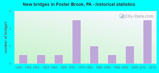
- New bridges - historical statistics
- 11940-1949
- 11950-1959
- 11960-1969
- 51970-1979
- 21980-1989
- 11990-1999
- 22000-2009
- 52010-2019

- Reconstructed bridges - Historical Statistics
- 12000-2009
- 12010-2019


- Bridge Condition - Deck
- 8.3%Excellent
- 25.0%Very good
- 25.0%Good
- 8.3%Satisfactory
- 25.0%Fair
- 8.3%Poor

- Bridge Condition - Superstructure
- 16.7%Excellent
- 16.7%Very good
- 33.3%Good
- 8.3%Satisfactory
- 8.3%Fair
- 16.7%Poor

- Bridge Condition - Substructure
- 8.3%Excellent
- 8.3%Very good
- 33.3%Good
- 16.7%Satisfactory
- 25.0%Fair
- 8.3%Poor

- Bridge Condition - Channel
- 7.1%Very good
- 35.7%Good
- 35.7%Satisfactory
- 21.4%Poor

- Bridge Condition - Culverts
- 50.0%Very good
- 25.0%Poor
- 25.0%Serious
Find on map >> Show street view
Structure Number: 25354, Location: BRADFORD (Lat: 41.978467, Lng: -78.625472), Route carried "on" structure: Bypass US 219, Year Built: 1977, Status: Open, Structure Length: 10.88m (35.70ft), Average Daily Traffic: 6,751 (year 2021), Truck Traffic: 17%, Average Future Daily Traffic: 9,321 (year 2041), Design Load: HS 20, Features Intersected: TUNUNGWANT CREEK
Minimum Vertical Clearance: 30+ m (98+ ft), Kilometerpoint: 44.061, Lanes on structure: 4, Base Highway Network: Yes, Owner: State Highway Agency, Approaching Roadway Width: 21.9m (71.9ft), Skew: 33 degrees, Material/Design: Steel continuous, Design/Construction: Stringer/Multi-beam, Number Of Spans In Main Unit: 3, Length of Maximum Span: 41.5m (136.2ft), Curb or Sidewalk Widths: Left: 0.2m (0.7ft), Right: 0.2m (0.7ft), Curb-To-Curb Width: 21.9m (71.9ft), Out-to-Out Width: 23.2m (76.1ft)
Condition: Deck: Fair, Superstructure: Good, Substructure: Fair, Channel: Satisfactory, Operating Rating: 59.0 metric tons, Method Used To Determine Operating Rating: Load Factor (LF), Inventory Rating: 35.4 metric tons, Method Used To Determine Inventory Rating: Load Factor (LF), Structural Evaluation: Somewhat better than minimum adequacy, Deck Geometry: Better than present minimum criteria, Waterway Adequacy: Superior to present desirable criteria, Approach Roadway Alignment: Equal to present desirable criteria, Length Of Structure Improvement: 10.90m (35.76ft), Designated Inspection Frequency: Every 24 months, Inspection Date: October 2019, Bridge Improvement Cost: $220,000, Roadway Improvement Cost: $648,000, Total Project Cost: $2,969,000, Deck Structure Type: Concrete Cast-file-Place, Wearing Surface/Protective System: Wearing Surface: Latex Concrete, Deck Protection: Galvanized Reinforcing
Find on map >> Show street view
Structure Number: 2536, Location: 1 MI N BRADFORD (Lat: 41.996328, Lng: -78.620297), Route carried "on" structure: US 219, Year Built: 1977, Year Reconstructed: 2009, Status: Open, Structure Length: 3.32m (10.89ft), Average Daily Traffic: 3,231 (year 2021), Truck Traffic: 17%, Average Future Daily Traffic: 4,707 (year 2041), Design Load: HS 20, Features Intersected: TOWNSHIP ROAD 369
Minimum Vertical Clearance: 30+ m (98+ ft), Kilometerpoint: 45.945, Lanes on structure: 2, Lanes under structure: 2, Base Highway Network: Yes, Owner: State Highway Agency, Approaching Roadway Width: 11.6m (38.1ft), Skew: 11 degrees, Material/Design: Prestressed concrete, Design/Construction: Box Beam or Girders - Multiple, Number Of Spans In Main Unit: 1, Length of Maximum Span: 32.0m (105.0ft), Curb or Sidewalk Widths: Left: 0.2m (0.7ft), Right: 0.2m (0.7ft), Curb-To-Curb Width: 12.1m (39.7ft), Out-to-Out Width: 13.4m (44.0ft)
Condition: Deck: Very good, Superstructure: Good, Substructure: Fair, Inventory Rating: 28.1 metric tons, Method Used To Determine Inventory Rating: Load Factor (LF), Structural Evaluation: Somewhat better than minimum adequacy, Deck Geometry: Better than present minimum criteria, Underclear: Somewhat better than minimum adequacy, Approach Roadway Alignment: Equal to present desirable criteria, Length Of Structure Improvement: 3.30m (10.83ft), Designated Inspection Frequency: Every 24 months, Inspection Date: October 2021, Bridge Improvement Cost: $66,000, Roadway Improvement Cost: $250,000, Total Project Cost: $886,000, Deck Structure Type: Concrete Cast-file-Place, Wearing Surface/Protective System: Wearing Surface: Monolithic Concrete, Deck Protection: Epoxy Coated Reinforcing
Find on map >> Show street view
Structure Number: 25361, Location: 2 MI N BRADFORD (Lat: 41.999131, Lng: -78.619194), Route carried "on" structure: US 219, Year Built: 1977, Year Reconstructed: 2010, Status: Open, Structure Length: 13.11m (43.01ft), Average Daily Traffic: 3,231 (year 2021), Truck Traffic: 17%, Average Future Daily Traffic: 4,707 (year 2041), Design Load: HS 20, Features Intersected: BUFF & PITT RR/PRIVATE
Minimum Vertical Clearance: 30+ m (98+ ft), Kilometerpoint: 45.945, Lanes on structure: 2, Base Highway Network: Yes, Owner: State Highway Agency, Approaching Roadway Width: 11.6m (38.1ft), Skew: 6 degrees, Material/Design: Steel continuous, Design/Construction: Stringer/Multi-beam, Number Of Spans In Main Unit: 4, Length of Maximum Span: 32.3m (106.0ft), Curb or Sidewalk Widths: Left: 0.2m (0.7ft), Right: 0.2m (0.7ft), Curb-To-Curb Width: 12.3m (40.4ft), Out-to-Out Width: 13.4m (44.0ft)
Condition: Deck: Fair, Superstructure: Satisfactory, Substructure: Satisfactory, Operating Rating: 65.3 metric tons, Method Used To Determine Operating Rating: Load Factor (LF), Inventory Rating: 39.0 metric tons, Method Used To Determine Inventory Rating: Load Factor (LF), Structural Evaluation: Equal to present minimum criteria, Deck Geometry: Better than present minimum criteria, Underclear: High priority of corrective action, Approach Roadway Alignment: Better than present minimum criteria, Length Of Structure Improvement: 19.30m (63.32ft), Designated Inspection Frequency: Every 24 months, Critical Feature Inspection Frequency: Every 24 months, Inspection Date: October 2021, Critical Feature Inspection Date: October 2020, Bridge Improvement Cost: $109,000, Roadway Improvement Cost: $322,000, Total Project Cost: $1,474,000, Deck Structure Type: Concrete Cast-file-Place, Wearing Surface/Protective System: Wearing Surface: Latex Concrete, Deck Protection: Galvanized Reinforcing
Find on map >> Show street view
Structure Number: 25362, Location: CORWINS CORNER (Lat: 41.933606, Lng: -78.580339), Route carried "on" structure: State highway 246, Year Built: 1954, Status: Open, Structure Length: 1.25m (4.10ft), Average Daily Traffic: 1,163 (year 2022), Truck Traffic: 2%, Average Future Daily Traffic: 1,383 (year 2041), Design Load: HS 20, Features Intersected: KENDALL CREEK
Minimum Vertical Clearance: 30+ m (98+ ft), Kilometerpoint: 0.000, Lanes on structure: 2, Owner: State Highway Agency, Approaching Roadway Width: 6.1m (20.0ft), Material/Design: Concrete, Design/Construction: Slab, Number Of Spans In Main Unit: 2, Length of Maximum Span: 5.8m (19.0ft), Curb or Sidewalk Widths: Left: 0.1m (0.3ft), Right: 0.1m (0.3ft), Curb-To-Curb Width: 10.1m (33.1ft), Out-to-Out Width: 11.3m (37.1ft)
Condition: Deck: Poor, Superstructure: Poor, Substructure: Fair, Channel: Poor, Operating Rating: 55.3 metric tons, Method Used To Determine Operating Rating: Field evaluation and documented engineering judgment, Inventory Rating: 32.7 metric tons, Method Used To Determine Inventory Rating: Field evaluation and documented engineering judgment, Structural Evaluation: Meets minimum limits, Deck Geometry: Somewhat better than minimum adequacy, Waterway Adequacy: Equal to present minimum criteria, Approach Roadway Alignment: Equal to present desirable criteria, Length Of Structure Improvement: 1.20m (3.94ft), Designated Inspection Frequency: Every 24 months, Inspection Date: September 2021, Bridge Improvement Cost: $30,000, Roadway Improvement Cost: $250,000, Total Project Cost: $402,000, Wearing Surface/Protective System: Wearing Surface: Bituminous
Find on map >> Show street view
Structure Number: 25558, Location: 250' NORTH OF SR 346 (Lat: 41.972700, Lng: -78.597497), Route carried "on" structure: City street , Year Built: 1940, Status: Posted for load, Structure Length: 1.68m (5.51ft), Average Daily Traffic: 250 (year 2018), Truck Traffic: 1%, Average Future Daily Traffic: 350 (year 2038), Design Load: HS 20, Features Intersected: FOSTER BROOK, Facility Carried by Structure: T-523 FAIRVIEW HTS
Minimum Vertical Clearance: 30+ m (98+ ft), Kilometerpoint: 0.000, Lanes on structure: 2, Owner: Town or Township Highway Agency, Approaching Roadway Width: 5.5m (18.0ft), Material/Design: Concrete, Design/Construction: Tee Beam, Number Of Spans In Main Unit: 2, Length of Maximum Span: 7.9m (25.9ft), Curb-To-Curb Width: 7.3m (24.0ft), Out-to-Out Width: 8.4m (27.6ft)
Condition: Deck: Fair, Superstructure: Poor, Substructure: Poor, Channel: Poor, Operating Rating: 23.6 metric tons, Method Used To Determine Operating Rating: Load Factor (LF), Inventory Rating: 13.6 metric tons, Method Used To Determine Inventory Rating: Load Factor (LF), Structural Evaluation: Meets minimum limits, Deck Geometry: Somewhat better than minimum adequacy, Waterway Adequacy: Better than present minimum criteria, Approach Roadway Alignment: Equal to present desirable criteria, Bridge Posting: Required (Relationship of Operating Rating to Maximum Legal Load: 30.0 - 39.9% below), Length Of Structure Improvement: 1.80m (5.91ft), Designated Inspection Frequency: Every 24 months, Other Special Inspection Frequency: Every 12 months, Inspection Date: September 2020, Other Special Inspection Date: September 2021, Bridge Improvement Cost: $39,000, Roadway Improvement Cost: $195,000, Total Project Cost: $528,000, Deck Structure Type: Concrete Cast-file-Place, Wearing Surface/Protective System: Wearing Surface: Bituminous
Find on map >> Show street view
Structure Number: 25562, Location: 1000 FT NE OF SR 46 (Lat: 41.956997, Lng: -78.606908), Route carried "on" structure: City street , Year Built: 1995, Status: Open, Structure Length: 1.16m (3.81ft), Average Daily Traffic: 150 (year 2018), Truck Traffic: 12%, Average Future Daily Traffic: 180 (year 2038), Design Load: HS 25 or greater, Features Intersected: KENDALL CREEK, Facility Carried by Structure: T-363 LAFFERTY HOL
Minimum Vertical Clearance: 30+ m (98+ ft), Kilometerpoint: 0.000, Lanes on structure: 2, Owner: Town or Township Highway Agency, Approaching Roadway Width: 5.8m (19.0ft), Material/Design: Prestressed concrete, Design/Construction: Box Beam or Girders - Multiple, Number Of Spans In Main Unit: 1, Length of Maximum Span: 11.3m (37.1ft), Curb-To-Curb Width: 7.0m (23.0ft), Out-to-Out Width: 7.6m (24.9ft)
Condition: Deck: Satisfactory, Superstructure: Good, Substructure: Good, Channel: Satisfactory, Inventory Rating: 91.6 metric tons, Method Used To Determine Inventory Rating: Load Factor (LF), Structural Evaluation: Better than present minimum criteria, Deck Geometry: Meets minimum limits, Waterway Adequacy: Equal to present minimum criteria, Approach Roadway Alignment: Equal to present desirable criteria, Designated Inspection Frequency: Every 24 months, Inspection Date: September 2020, Deck Structure Type: Concrete Cast-file-Place, Wearing Surface/Protective System: Wearing Surface: Monolithic Concrete, Deck Protection: Epoxy Coated Reinforcing
Find on map >> Show street view
Structure Number: 25565, Location: 100' SOUTH OF SR 346 (Lat: 41.971372, Lng: -78.574656), Route carried "on" structure: City street , Year Built: 1980, Status: Posted for load, Structure Length: 0.98m (3.22ft), Average Daily Traffic: 70 (year 2018), Truck Traffic: 2%, Average Future Daily Traffic: 70 (year 2038), Design Load: HS 20, Features Intersected: FOSTER BROOK, Facility Carried by Structure: T-576 BJ ROAD
Minimum Vertical Clearance: 30+ m (98+ ft), Kilometerpoint: 0.000, Lanes on structure: 2, Owner: Town or Township Highway Agency, Approaching Roadway Width: 4.9m (16.1ft), Material/Design: Steel, Design/Construction: Culvert, Number Of Spans In Main Unit: 2, Length of Maximum Span: 4.3m (14.1ft)
Condition: Channel: Satisfactory, Culverts: Serious, Operating Rating: 22.7 metric tons, Method Used To Determine Operating Rating: Field evaluation and documented engineering judgment, Inventory Rating: 13.6 metric tons, Method Used To Determine Inventory Rating: Field evaluation and documented engineering judgment, Structural Evaluation: High priority of corrective action, Waterway Adequacy: Equal to present desirable criteria, Approach Roadway Alignment: Equal to present desirable criteria, Bridge Posting: Required (Relationship of Operating Rating to Maximum Legal Load: 30.0 - 39.9% below), Designated Inspection Frequency: Every 24 months, Other Special Inspection Frequency: Every 6 months, Inspection Date: September 2020, Other Special Inspection Date: September 2021
Find on map >> Show street view
Structure Number: 25566, Location: FOSTER BROOK (Lat: 41.978506, Lng: -78.617214), Route carried "on" structure: State highway , Year Built: 1960, Status: Open, Structure Length: 1.83m (6.00ft), Average Daily Traffic: 7,113 (year 2022), Truck Traffic: 2%, Average Future Daily Traffic: 10,936 (year 2040), Design Load: HS 20, Features Intersected: FOSTER BROOK, Facility Carried by Structure: ON TSR 601
Minimum Vertical Clearance: 30+ m (98+ ft), Kilometerpoint: 4.817, Lanes on structure: 2, Owner: State Highway Agency, Approaching Roadway Width: 12.2m (40.0ft), Material/Design: Prestressed concrete, Design/Construction: Box Beam or Girders - Multiple, Number Of Spans In Main Unit: 1, Length of Maximum Span: 17.7m (58.1ft), Curb or Sidewalk Widths: Left: 0.5m (1.6ft), Right: 1.5m (4.9ft), Curb-To-Curb Width: 12.2m (40.0ft), Out-to-Out Width: 14.9m (48.9ft)
Condition: Deck: Good, Superstructure: Fair, Substructure: Satisfactory, Channel: Satisfactory, Operating Rating: 57.2 metric tons, Method Used To Determine Operating Rating: Load Factor (LF), Inventory Rating: 15.4 metric tons, Method Used To Determine Inventory Rating: Load Factor (LF), Structural Evaluation: High priority of corrective action, Deck Geometry: Somewhat better than minimum adequacy, Waterway Adequacy: Equal to present desirable criteria, Approach Roadway Alignment: Equal to present desirable criteria, Length Of Structure Improvement: 2.10m (6.89ft), Designated Inspection Frequency: Every 24 months, Inspection Date: June 2020, Bridge Improvement Cost: $5,000, Roadway Improvement Cost: $14,000, Total Project Cost: $65,000, Deck Structure Type: Concrete Cast-file-Place, Wearing Surface/Protective System: Wearing Surface: Bituminous, Membrane: Preformed Fabric
Find on map >> Show street view
Structure Number: 25568, Location: 400 FT NORTH OF SR 346 (Lat: 41.976647, Lng: -78.610219), Route carried "on" structure: City street , Year Built: 1980, Status: Open, Structure Length: 0.70m (2.30ft), Average Daily Traffic: 10 (year 2018), Truck Traffic: 20%, Average Future Daily Traffic: 10 (year 2038), Design Load: HS 20, Features Intersected: FOSTER BROOK, Facility Carried by Structure: NORTH 4TH STREET
Minimum Vertical Clearance: 30+ m (98+ ft), Kilometerpoint: 0.000, Lanes on structure: 2, Owner: Town or Township Highway Agency, Approaching Roadway Width: 5.2m (17.1ft), Material/Design: Steel, Design/Construction: Culvert, Number Of Spans In Main Unit: 1, Length of Maximum Span: 7.0m (23.0ft), Out-to-Out Width: 12.1m (39.7ft)
Condition: Channel: Poor, Culverts: Poor, Operating Rating: 42.6 metric tons, Method Used To Determine Operating Rating: Field evaluation and documented engineering judgment, Inventory Rating: 21.8 metric tons, Method Used To Determine Inventory Rating: Field evaluation and documented engineering judgment, Structural Evaluation: Meets minimum limits, Waterway Adequacy: Better than present minimum criteria, Approach Roadway Alignment: Equal to present desirable criteria, Length Of Structure Improvement: 0.70m (2.30ft), Designated Inspection Frequency: Every 24 months, Other Special Inspection Frequency: Every 12 months, Inspection Date: September 2020, Other Special Inspection Date: September 2021, Bridge Improvement Cost: $15,000, Roadway Improvement Cost: $51,000, Total Project Cost: $206,000
Find on map >> Show street view
Structure Number: 41295, Location: 275 FT NE OF SR 46 (Lat: 41.942556, Lng: -78.593600), Route carried "on" structure: City street , Year Built: 2001, Status: Open, Structure Length: 1.65m (5.41ft), Average Daily Traffic: 100 (year 2016), Truck Traffic: 5%, Average Future Daily Traffic: 125 (year 2036), Design Load: HS 25 or greater, Features Intersected: KENDALL CREEK, Facility Carried by Structure: T361 TOTTEN HOLLOW
Minimum Vertical Clearance: 30+ m (98+ ft), Kilometerpoint: 0.000, Lanes on structure: 2, Owner: Town or Township Highway Agency, Approaching Roadway Width: 7.6m (24.9ft), Skew: 4 degrees, Material/Design: Prestressed concrete, Design/Construction: Box Beam or Girders - Single/Spread, Number Of Spans In Main Unit: 1, Length of Maximum Span: 15.8m (51.8ft), Curb or Sidewalk Widths: Left: 0.1m (0.3ft), Right: 0.1m (0.3ft), Curb-To-Curb Width: 7.8m (25.6ft), Out-to-Out Width: 8.7m (28.5ft)
Condition: Deck: Good, Superstructure: Very good, Substructure: Good, Channel: Satisfactory, Operating Rating: 64.4 metric tons, Method Used To Determine Operating Rating: Load Factor (LF), Inventory Rating: 38.1 metric tons, Method Used To Determine Inventory Rating: Load Factor (LF), Structural Evaluation: Better than present minimum criteria, Deck Geometry: Equal to present minimum criteria, Waterway Adequacy: Equal to present desirable criteria, Approach Roadway Alignment: Equal to present desirable criteria, Length Of Structure Improvement: 1.60m (5.25ft), Designated Inspection Frequency: Every 24 months, Inspection Date: August 2020, Deck Structure Type: Concrete Cast-file-Place, Wearing Surface/Protective System: Wearing Surface: Monolithic Concrete, Deck Protection: Epoxy Coated Reinforcing
Find on map >> Show street view
Structure Number: 43372, Location: 1500 FT WEST OF E MAIN ST (Lat: 41.996714, Lng: -78.623722), Route carried "on" structure: City street 7206, Year Built: 2007, Status: Open, Structure Length: 6.19m (20.31ft), Average Daily Traffic: 100 (year 2018), Truck Traffic: 6%, Average Future Daily Traffic: 130 (year 2038), Design Load: HL 93, Features Intersected: TUNUNGWANT CREEK, Facility Carried by Structure: T369 TUNA CROSS RD
Minimum Vertical Clearance: 30+ m (98+ ft), Kilometerpoint: 0.000, Lanes on structure: 2, Owner: Town or Township Highway Agency, Approaching Roadway Width: 8.8m (28.9ft), Skew: 1 degrees, Material/Design: Prestressed concrete, Design/Construction: Box Beam or Girders - Multiple, Number Of Spans In Main Unit: 2, Length of Maximum Span: 30.5m (100.1ft), Curb or Sidewalk Widths: Left: 0.2m (0.7ft), Right: 1.5m (4.9ft), Curb-To-Curb Width: 8.8m (28.9ft), Out-to-Out Width: 11.2m (36.7ft)
Condition: Deck: Good, Superstructure: Good, Substructure: Good, Channel: Good, Operating Rating: 86.2 metric tons, Method Used To Determine Operating Rating: Load and Resistance Factor (LRFR), Inventory Rating: 45.4 metric tons, Method Used To Determine Inventory Rating: Load and Resistance Factor (LRFR), Structural Evaluation: Better than present minimum criteria, Deck Geometry: Better than present minimum criteria, Waterway Adequacy: Superior to present desirable criteria, Approach Roadway Alignment: Better than present minimum criteria, Designated Inspection Frequency: Every 24 months, Inspection Date: September 2020, Deck Structure Type: Concrete Cast-file-Place, Wearing Surface/Protective System: Wearing Surface: Monolithic Concrete, Deck Protection: Epoxy Coated Reinforcing
Find on map >> Show street view
Structure Number: 4878, Location: 1 MI E GILMORE (Lat: 41.967264, Lng: -78.554872), Route carried "on" structure: State highway 346, Year Built: 2014, Status: Open, Structure Length: 0.67m (2.20ft), Average Daily Traffic: 1,660 (year 2021), Truck Traffic: 6%, Average Future Daily Traffic: 1,905 (year 2041), Design Load: HL 93, Features Intersected: BRANCH FOSTER BROOK
Minimum Vertical Clearance: 30+ m (98+ ft), Kilometerpoint: 31.397, Lanes on structure: 2, Owner: State Highway Agency, Approaching Roadway Width: 6.1m (20.0ft), Skew: 2 degrees, Material/Design: Concrete, Design/Construction: Culvert, Number Of Spans In Main Unit: 1, Length of Maximum Span: 6.7m (22.0ft)
Condition: Channel: Good, Culverts: Very good, Operating Rating: 52.2 metric tons, Method Used To Determine Operating Rating: Assigned ratings based on Load and Resistance Factor Design (LRFD) reported by rating factor (RF) using HL93 loadings, Inventory Rating: 32.7 metric tons, Method Used To Determine Inventory Rating: Assigned ratings based on Load and Resistance Factor Design (LRFD) reported by rating factor (RF) using HL93 loadings, Structural Evaluation: Equal to present desirable criteria, Waterway Adequacy: Equal to present desirable criteria, Approach Roadway Alignment: Equal to present desirable criteria, Designated Inspection Frequency: Every 24 months, Inspection Date: October 2021
Find on map >> Show street view
Structure Number: 53928, Location: 3 MI E BRADFORD (Lat: 41.971744, Lng: -78.584089), Route carried "on" structure: State highway 346, Year Built: 2017, Status: Open, Structure Length: 2.01m (6.59ft), Average Daily Traffic: 3,164 (year 2022), Truck Traffic: 2%, Average Future Daily Traffic: 3,696 (year 2037), Design Load: HL 93, Features Intersected: Foster Brook
Minimum Vertical Clearance: 30+ m (98+ ft), Kilometerpoint: 28.915, Lanes on structure: 2, Owner: State Highway Agency, Maintenance Responsibility: Private, Approaching Roadway Width: 8.8m (28.9ft), Skew: 4 degrees, Material/Design: Prestressed concrete, Design/Construction: Box Beam or Girders - Single/Spread, Number Of Spans In Main Unit: 1, Length of Maximum Span: 18.6m (61.0ft), Curb-To-Curb Width: 12.4m (40.7ft), Out-to-Out Width: 13.0m (42.7ft)
Condition: Deck: Excellent, Superstructure: Excellent, Substructure: Excellent, Channel: Very good, Operating Rating: 51.5 metric tons, Method Used To Determine Operating Rating: Assigned ratings based on Load and Resistance Factor Design (LRFD) reported by rating factor (RF) using HL93 loadings, Inventory Rating: 39.5 metric tons, Method Used To Determine Inventory Rating: Assigned ratings based on Load and Resistance Factor Design (LRFD) reported by rating factor (RF) using HL93 loadings, Structural Evaluation: Superior to present desirable criteria, Deck Geometry: Equal to present minimum criteria, Waterway Adequacy: Superior to present desirable criteria, Approach Roadway Alignment: Equal to present desirable criteria, Designated Inspection Frequency: Every 24 months, Inspection Date: June 2021, Deck Structure Type: Concrete Cast-file-Place, Wearing Surface/Protective System: Wearing Surface: Integral Concrete, Deck Protection: Epoxy Coated Reinforcing
Find on map >> Show street view
Structure Number: 53929, Location: DERRICK CITY (Lat: 41.971583, Lng: -78.572811), Route carried "on" structure: State highway 346, Year Built: 2018, Status: Open, Structure Length: 2.23m (7.32ft), Average Daily Traffic: 3,164 (year 2022), Truck Traffic: 2%, Average Future Daily Traffic: 4,051 (year 2037), Design Load: HL 93, Features Intersected: Foster Brook, Facility Carried by Structure: Derrick Road
Minimum Vertical Clearance: 30+ m (98+ ft), Kilometerpoint: 29.723, Lanes on structure: 2, Owner: State Highway Agency, Maintenance Responsibility: Private, Approaching Roadway Width: 8.5m (27.9ft), Skew: 3 degrees, Material/Design: Prestressed concrete, Design/Construction: Box Beam or Girders - Single/Spread, Number Of Spans In Main Unit: 1, Length of Maximum Span: 20.7m (67.9ft), Curb-To-Curb Width: 12.6m (41.3ft), Out-to-Out Width: 13.2m (43.3ft)
Condition: Deck: Very good, Superstructure: Excellent, Substructure: Good, Channel: Good, Operating Rating: 45.4 metric tons, Method Used To Determine Operating Rating: Assigned ratings based on Load and Resistance Factor Design (LRFD) reported by rating factor (RF) using HL93 loadings, Inventory Rating: 35.0 metric tons, Method Used To Determine Inventory Rating: Assigned ratings based on Load and Resistance Factor Design (LRFD) reported by rating factor (RF) using HL93 loadings, Structural Evaluation: Better than present minimum criteria, Deck Geometry: Equal to present minimum criteria, Waterway Adequacy: Equal to present desirable criteria, Approach Roadway Alignment: Equal to present desirable criteria, Designated Inspection Frequency: Every 24 months, Inspection Date: July 2020, Deck Structure Type: Concrete Cast-file-Place, Wearing Surface/Protective System: Wearing Surface: Integral Concrete, Deck Protection: Epoxy Coated Reinforcing
Find on map >> Show street view
Structure Number: 5393, Location: 1 MI N GILMORE (Lat: 41.978583, Lng: -78.557131), Route carried "on" structure: State highway 646, Year Built: 2018, Status: Open, Structure Length: 1.01m (3.31ft), Average Daily Traffic: 976 (year 2022), Truck Traffic: 2%, Average Future Daily Traffic: 1,626 (year 2037), Design Load: HL 93, Features Intersected: Pennbrook Run, Facility Carried by Structure: Olean Rd
Minimum Vertical Clearance: 30+ m (98+ ft), Kilometerpoint: 23.504, Lanes on structure: 2, Owner: State Highway Agency, Maintenance Responsibility: Private, Approaching Roadway Width: 7.9m (25.9ft), Skew: 4 degrees, Material/Design: Concrete, Design/Construction: Culvert, Number Of Spans In Main Unit: 1, Length of Maximum Span: 9.1m (29.9ft), Curb-To-Curb Width: 9.8m (32.2ft), Out-to-Out Width: 11.1m (36.4ft)
Condition: Channel: Good, Culverts: Very good, Operating Rating: 70.6 metric tons, Method Used To Determine Operating Rating: Assigned ratings based on Load and Resistance Factor Design (LRFD) reported by rating factor (RF) using HL93 loadings, Inventory Rating: 44.4 metric tons, Method Used To Determine Inventory Rating: Assigned ratings based on Load and Resistance Factor Design (LRFD) reported by rating factor (RF) using HL93 loadings, Structural Evaluation: Equal to present desirable criteria, Deck Geometry: Equal to present minimum criteria, Waterway Adequacy: Superior to present desirable criteria, Approach Roadway Alignment: Equal to present desirable criteria, Designated Inspection Frequency: Every 24 months, Inspection Date: April 2020, Wearing Surface/Protective System: Wearing Surface: Bituminous, Membrane: Preformed Fabric
Find on map >> Show street view
Structure Number: 54417, Location: GILMORE (Lat: 41.972028, Lng: -78.566500), Route carried "on" structure: State highway 646, Year Built: 2017, Status: Open, Structure Length: 0.98m (3.22ft), Average Daily Traffic: 976 (year 2022), Truck Traffic: 2%, Average Future Daily Traffic: 1,741 (year 2041), Design Load: HL 93, Features Intersected: FOSTER BROOK
Minimum Vertical Clearance: 30+ m (98+ ft), Kilometerpoint: 22.323, Lanes on structure: 2, Owner: State Highway Agency, Approaching Roadway Width: 9.1m (29.9ft), Skew: 1 degrees, Material/Design: Prestressed concrete, Design/Construction: Box Beam or Girders - Single/Spread, Number Of Spans In Main Unit: 1, Length of Maximum Span: 9.8m (32.2ft), Curb or Sidewalk Widths: Left: 0.2m (0.7ft), Right: 0.2m (0.7ft), Curb-To-Curb Width: 11.0m (36.1ft), Out-to-Out Width: 12.0m (39.4ft)
Condition: Deck: Very good, Superstructure: Very good, Substructure: Very good, Channel: Good, Operating Rating: 45.4 metric tons, Method Used To Determine Operating Rating: Assigned ratings based on Load and Resistance Factor Design (LRFD) reported by rating factor (RF) using HL93 loadings, Inventory Rating: 35.0 metric tons, Method Used To Determine Inventory Rating: Assigned ratings based on Load and Resistance Factor Design (LRFD) reported by rating factor (RF) using HL93 loadings, Structural Evaluation: Equal to present desirable criteria, Deck Geometry: Better than present minimum criteria, Waterway Adequacy: Equal to present minimum criteria, Approach Roadway Alignment: Equal to present minimum criteria, Designated Inspection Frequency: Every 24 months, Inspection Date: August 2021, Deck Structure Type: Concrete Cast-file-Place, Wearing Surface/Protective System: Wearing Surface: Monolithic Concrete, Deck Protection: Epoxy Coated Reinforcing
Find on map >> Show street view
Structure Number: 25358, Location: 1 MI N BRADFORD (Lat: 41.996311, Lng: -78.619956), Route carried "under" structure: City street , Year Built: 1977, Structure Length: 0. m, Average Daily Traffic: 100 (year 1985), Truck Traffic: 10%, Features Intersected: TOWNSHIP ROAD 369, Facility Carried by Structure: SR 219-US 219
Minimum Vertical Clearance: 4.49m (14.73ft), Kilometerpoint: 0.000, Lanes on structure: 2, Lanes under structure: 2, Material/Design: Prestressed concrete, Design/Construction: Box Beam or Girders - Multiple, Length of Maximum Span: 32.0m (105.0ft)
Find on map >> Show street view
Structure Number: 2536, Location: 1 MI N BRADFORD (Lat: 41.996328, Lng: -78.620297), Route carried "under" structure: City street , Year Built: 1977, Structure Length: 0. m, Average Daily Traffic: 100 (year 1985), Truck Traffic: 10%, Features Intersected: TOWNSHIP ROAD 369, Facility Carried by Structure: SR 219-US 219
Minimum Vertical Clearance: 4.38m (14.37ft), Kilometerpoint: 0.000, Lanes on structure: 2, Lanes under structure: 2, Material/Design: Prestressed concrete, Design/Construction: Box Beam or Girders - Multiple, Length of Maximum Span: 32.0m (105.0ft)