Bridge Statistics for Fort Knox, Kentucky (KY)
Condition, Traffic, Stress, Structural Evaluation, Project Costs
- National Bridge Inventory (NBI) Statistics
- 37Number of bridges
- 436ft / 133mTotal length
- $4,720,000Total costs
- 104,357Total average daily traffic
- 8,247Total average daily truck traffic
- National Bridge Inventory (NBI) Registered Bridges for Fort Knox
- No street view available for this location
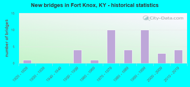
- New bridges - historical statistics
- 11920-1929
- 41950-1959
- 11960-1969
- 101970-1979
- 41980-1989
- 101990-1999
- 32000-2009
- 42010-2019

- Reconstructed bridges - Historical Statistics
- 11990-1999
- 32000-2009


- Bridge Condition - Deck
- 81.0%Good
- 4.8%Satisfactory
- 9.5%Fair
- 4.8%Poor

- Bridge Condition - Superstructure
- 12.0%Very good
- 64.0%Good
- 12.0%Satisfactory
- 8.0%Fair
- 4.0%Poor

- Bridge Condition - Substructure
- 4.0%Very good
- 56.0%Good
- 36.0%Satisfactory
- 4.0%Poor

- Bridge Condition - Channel
- 11.5%Very good
- 38.5%Good
- 46.2%Satisfactory
- 3.8%Fair

- Bridge Condition - Culverts
- 12.5%Very good
- 50.0%Good
- 37.5%Satisfactory
Find on map >> Show street view
Structure Number: 47B00111N, Location: BULLION BLVD OVER US 31W (Lat: 37.878333, Lng: -85.965556), Route carried "on" structure: State highway 361, Year Built: 1974, Status: Open, Structure Length: 6.68m (21.92ft), Average Daily Traffic: 8,136 (year 2018), Truck Traffic: 8%, Average Future Daily Traffic: 7,566 (year 2038), Design Load: HS 20+Mod, Features Intersected: US 31W
Minimum Vertical Clearance: 30+ m (98+ ft), Kilometerpoint: 19.650, Lanes on structure: 4, Lanes under structure: 5, Owner: State Highway Agency, Approaching Roadway Width: 23.2m (76.1ft), Skew: 20 degrees, Material/Design: Prestressed concrete continuous, Design/Construction: Stringer/Multi-beam, Number Of Spans In Main Unit: 4, Length of Maximum Span: 20.1m (65.9ft), Curb or Sidewalk Widths: Left: 0.2m (0.7ft), Right: 0.2m (0.7ft), Curb-To-Curb Width: 25.2m (82.7ft), Out-to-Out Width: 26.1m (85.6ft)
Condition: Deck: Fair, Superstructure: Good, Substructure: Satisfactory, Operating Rating: 94.7 metric tons, Method Used To Determine Operating Rating: Load Factor (LF), Inventory Rating: 56.9 metric tons, Method Used To Determine Inventory Rating: Load Factor (LF), Structural Evaluation: Equal to present minimum criteria, Deck Geometry: Superior to present desirable criteria, Underclear: Meets minimum limits, Approach Roadway Alignment: Better than present minimum criteria, Length Of Structure Improvement: 0.67m (2.20ft), Designated Inspection Frequency: Every 24 months, Inspection Date: November 2021, Bridge Improvement Cost: $2,341,000, Total Project Cost: $2,340,000, Deck Structure Type: Concrete Cast-file-Place, Wearing Surface/Protective System: Wearing Surface: Monolithic Concrete
Find on map >> Show street view
Structure Number: 47B00112N, Location: 1.1 MI N OF BULLION BLVD (Lat: 37.892778, Lng: -85.974167), Route carried "on" structure: US 31, Year Built: 1973, Status: Open, Structure Length: 6.55m (21.49ft), Average Daily Traffic: 12,066 (year 2020), Truck Traffic: 6%, Average Future Daily Traffic: 11,342 (year 2040), Design Load: HS 20, Features Intersected: CHAFFEE AVENUE
Minimum Vertical Clearance: 30+ m (98+ ft), Kilometerpoint: 51.367, Lanes on structure: 4, Lanes under structure: 2, Base Highway Network: Yes, Owner: State Highway Agency, Approaching Roadway Width: 22.6m (74.1ft), Skew: 30 degrees, Material/Design: Prestressed concrete continuous, Design/Construction: Stringer/Multi-beam, Number Of Spans In Main Unit: 4, Length of Maximum Span: 21.3m (69.9ft), Curb-To-Curb Width: 25.0m (82.0ft), Out-to-Out Width: 25.5m (83.7ft)
Condition: Deck: Good, Superstructure: Good, Substructure: Good, Operating Rating: 95.7 metric tons, Method Used To Determine Operating Rating: Load Factor (LF), Inventory Rating: 57.4 metric tons, Method Used To Determine Inventory Rating: Load Factor (LF), Structural Evaluation: Better than present minimum criteria, Deck Geometry: Superior to present desirable criteria, Underclear: Meets minimum limits, Approach Roadway Alignment: Better than present minimum criteria, Length Of Structure Improvement: 0.66m (2.17ft), Designated Inspection Frequency: Every 24 months, Inspection Date: November 2020, Bridge Improvement Cost: $2,244,000, Total Project Cost: $2,244,000, Deck Structure Type: Concrete Cast-file-Place, Wearing Surface/Protective System: Wearing Surface: Low Slump Concrete, Deck Protection: Epoxy Coated Reinforcing
Find on map >> Show street view
Structure Number: 47B00114N, Location: NB EXIT RAMP @CHAFFEE AVE (Lat: 37.892500, Lng: -85.974167), Route carried "on" structure: US 31, Year Built: 1973, Status: Open, Structure Length: 0.85m (2.79ft), Average Daily Traffic: 15,505 (year 2019), Truck Traffic: 6%, Average Future Daily Traffic: 14,574 (year 2039), Design Load: HS 20+Mod, Features Intersected: DRY BRANCH
Minimum Vertical Clearance: 30+ m (98+ ft), Kilometerpoint: 51.312, Lanes on structure: 4, Base Highway Network: Yes, Owner: State Highway Agency, Approaching Roadway Width: 22.6m (74.1ft), Skew: 11 degrees, Material/Design: Concrete, Design/Construction: Culvert, Number Of Spans In Main Unit: 3, Length of Maximum Span: 2.4m (7.9ft)
Condition: Channel: Good, Culverts: Good, Operating Rating: 89.8 metric tons, Method Used To Determine Operating Rating: Field evaluation and documented engineering judgment, Inventory Rating: 89.8 metric tons, Method Used To Determine Inventory Rating: Field evaluation and documented engineering judgment, Structural Evaluation: Better than present minimum criteria, Waterway Adequacy: Better than present minimum criteria, Approach Roadway Alignment: Better than present minimum criteria, Designated Inspection Frequency: Every 24 months, Inspection Date: November 2020
Find on map >> Show street view
Structure Number: 47B00115N, Location: SB ENTR RAMP @CHAFFEE AVE (Lat: 37.891944, Lng: -85.975278), Route carried "on" structure: Ramp US 31, Year Built: 1973, Status: Open, Structure Length: 0.82m (2.69ft), Average Daily Traffic: 3,164 (year 2019), Truck Traffic: 13%, Average Future Daily Traffic: 2,784 (year 2039), Features Intersected: DRY BRANCH, Facility Carried by Structure: DIXIE HIGHWAY RAMP
Minimum Vertical Clearance: 30+ m (98+ ft), Kilometerpoint: 0.080, Lanes on structure: 2, Owner: State Highway Agency, Approaching Roadway Width: 15.2m (49.9ft), Material/Design: Concrete, Design/Construction: Culvert, Number Of Spans In Main Unit: 2, Length of Maximum Span: 3.7m (12.1ft)
Condition: Channel: Good, Culverts: Good, Operating Rating: 54.4 metric tons, Method Used To Determine Operating Rating: Field evaluation and documented engineering judgment, Inventory Rating: 39.9 metric tons, Method Used To Determine Inventory Rating: Field evaluation and documented engineering judgment, Structural Evaluation: Better than present minimum criteria, Waterway Adequacy: Better than present minimum criteria, Approach Roadway Alignment: Better than present minimum criteria, Designated Inspection Frequency: Every 24 months, Inspection Date: November 2021
Find on map >> Show street view
Structure Number: 82B00014N, Location: 4.5 MI.E.-KY 144 (Lat: 37.901667, Lng: -86.025000), Route carried "on" structure: US 60, Year Built: 1981, Status: Open, Structure Length: 7.59m (24.90ft), Average Daily Traffic: 7,736 (year 2019), Truck Traffic: 11%, Average Future Daily Traffic: 6,420 (year 2039), Design Load: HS 20, Features Intersected: OTTER CREEK
Minimum Vertical Clearance: 30+ m (98+ ft), Kilometerpoint: 20.118, Lanes on structure: 2, Base Highway Network: Yes, Owner: State Highway Agency, Approaching Roadway Width: 13.4m (44.0ft), Material/Design: Prestressed concrete continuous, Design/Construction: Stringer/Multi-beam, Number Of Spans In Main Unit: 3, Length of Maximum Span: 30.5m (100.1ft), Curb-To-Curb Width: 13.4m (44.0ft), Out-to-Out Width: 14.5m (47.6ft)
Condition: Deck: Good, Superstructure: Very good, Substructure: Good, Channel: Very good, Operating Rating: 99.8 metric tons, Method Used To Determine Operating Rating: Load Factor (LF), Inventory Rating: 69.7 metric tons, Method Used To Determine Inventory Rating: Load Factor (LF), Structural Evaluation: Better than present minimum criteria, Deck Geometry: Equal to present minimum criteria, Waterway Adequacy: Equal to present desirable criteria, Approach Roadway Alignment: Equal to present minimum criteria, Designated Inspection Frequency: Every 24 months, Inspection Date: January 2020, Deck Structure Type: Concrete Cast-file-Place, Wearing Surface/Protective System: Wearing Surface: Monolithic Concrete
Find on map >> Show street view
Structure Number: 82B00015N, Location: 3.7 MI E. KY 144 (Lat: 37.894444, Lng: -86.037500), Route carried "on" structure: US 60, Year Built: 1981, Status: Open, Structure Length: 1.49m (4.89ft), Average Daily Traffic: 7,736 (year 2019), Truck Traffic: 11%, Average Future Daily Traffic: 6,420 (year 2039), Design Load: HS 20, Features Intersected: TANK TRAIL
Minimum Vertical Clearance: 30+ m (98+ ft), Kilometerpoint: 18.762, Lanes on structure: 2, Base Highway Network: Yes, Owner: State Highway Agency, Approaching Roadway Width: 18.0m (59.1ft), Material/Design: Prestressed concrete, Design/Construction: Stringer/Multi-beam, Number Of Spans In Main Unit: 1, Length of Maximum Span: 14.9m (48.9ft), Curb-To-Curb Width: 17.1m (56.1ft), Out-to-Out Width: 18.0m (59.1ft)
Condition: Deck: Good, Superstructure: Good, Substructure: Good, Operating Rating: 78.5 metric tons, Method Used To Determine Operating Rating: Load Factor (LF), Inventory Rating: 47.1 metric tons, Method Used To Determine Inventory Rating: Load Factor (LF), Structural Evaluation: Better than present minimum criteria, Deck Geometry: Superior to present desirable criteria, Approach Roadway Alignment: Equal to present minimum criteria, Designated Inspection Frequency: Every 24 months, Inspection Date: January 2021, Deck Structure Type: Concrete Cast-file-Place
Find on map >> Show street view
Structure Number: 82B00016N, Location: 4.9 MI E. KY 144 (Lat: 37.905000, Lng: -86.018889), Route carried "on" structure: Federal lands road 1449, Year Built: 1981, Status: Open, Structure Length: 5.58m (18.31ft), Average Daily Traffic: 12 (year 2006), Average Future Daily Traffic: 14 (year 2026), Features Intersected: US 60, Facility Carried by Structure: PINWHEEL RD
Minimum Vertical Clearance: 30+ m (98+ ft), Kilometerpoint: 5.742, Lanes on structure: 2, Lanes under structure: 2, Owner: State Highway Agency, Approaching Roadway Width: 7.3m (24.0ft), Material/Design: Prestressed concrete continuous, Design/Construction: Stringer/Multi-beam, Number Of Spans In Main Unit: 3, Length of Maximum Span: 29.9m (98.1ft), Curb-To-Curb Width: 7.4m (24.3ft), Out-to-Out Width: 8.4m (27.6ft)
Condition: Deck: Good, Superstructure: Good, Substructure: Good, Operating Rating: 99.8 metric tons, Method Used To Determine Operating Rating: Load Factor (LF), Inventory Rating: 98.9 metric tons, Method Used To Determine Inventory Rating: Load Factor (LF), Structural Evaluation: Better than present minimum criteria, Deck Geometry: Equal to present minimum criteria, Underclear: Superior to present desirable criteria, Approach Roadway Alignment: Equal to present minimum criteria, Designated Inspection Frequency: Every 24 months, Inspection Date: January 2020, Deck Structure Type: Concrete Cast-file-Place, Wearing Surface/Protective System: Wearing Surface: Other, Deck Protection: Epoxy Coated Reinforcing
Find on map >> Show street view
Structure Number: 82B00019N, Location: 1.5 M E JCT KY 1238 (Lat: 37.922500, Lng: -86.030278), Route carried "on" structure: State highway 1638, Year Built: 1990, Status: Open, Structure Length: 15.45m (50.69ft), Average Daily Traffic: 7,458 (year 2020), Truck Traffic: 7%, Average Future Daily Traffic: 6,190 (year 2040), Design Load: HS 25 or greater, Features Intersected: OTTER CREEK
Minimum Vertical Clearance: 30+ m (98+ ft), Kilometerpoint: 10.898, Lanes on structure: 2, Base Highway Network: Yes, Owner: State Highway Agency, Approaching Roadway Width: 9.1m (29.9ft), Skew: 4 degrees, Material/Design: Prestressed concrete continuous, Design/Construction: Stringer/Multi-beam, Number Of Spans In Main Unit: 5, Length of Maximum Span: 30.5m (100.1ft), Curb-To-Curb Width: 9.1m (29.9ft), Out-to-Out Width: 10.1m (33.1ft)
Condition: Deck: Good, Superstructure: Good, Substructure: Good, Channel: Good, Operating Rating: 68.5 metric tons, Method Used To Determine Operating Rating: Load Factor (LF), Inventory Rating: 41.1 metric tons, Method Used To Determine Inventory Rating: Load Factor (LF), Structural Evaluation: Better than present minimum criteria, Deck Geometry: Meets minimum limits, Waterway Adequacy: Equal to present desirable criteria, Approach Roadway Alignment: Better than present minimum criteria, Designated Inspection Frequency: Every 24 months, Inspection Date: January 2021, Deck Structure Type: Concrete Cast-file-Place, Wearing Surface/Protective System: Wearing Surface: Monolithic Concrete, Deck Protection: Epoxy Coated Reinforcing
Find on map >> Show street view
Structure Number: 82B00020N, Location: 1.2MI.E JCT. KY 1882 (Lat: 37.863056, Lng: -86.004167), Route carried "on" structure: State highway 1816, Year Built: 1993, Status: Open, Structure Length: 3.72m (12.20ft), Average Daily Traffic: 532 (year 2019), Average Future Daily Traffic: 462 (year 2039), Design Load: HS 25 or greater, Features Intersected: OTTER CREEK
Minimum Vertical Clearance: 30+ m (98+ ft), Kilometerpoint: 7.776, Lanes on structure: 2, Owner: State Highway Agency, Approaching Roadway Width: 11.6m (38.1ft), Material/Design: Prestressed concrete continuous, Design/Construction: Stringer/Multi-beam, Number Of Spans In Main Unit: 2, Length of Maximum Span: 18.3m (60.0ft), Curb-To-Curb Width: 9.2m (30.2ft), Out-to-Out Width: 10.2m (33.5ft)
Condition: Deck: Good, Superstructure: Very good, Substructure: Very good, Channel: Good, Operating Rating: 70.1 metric tons, Method Used To Determine Operating Rating: Load Factor (LF), Inventory Rating: 42.1 metric tons, Method Used To Determine Inventory Rating: Load Factor (LF), Structural Evaluation: Equal to present desirable criteria, Deck Geometry: Equal to present minimum criteria, Waterway Adequacy: Better than present minimum criteria, Approach Roadway Alignment: Equal to present minimum criteria, Designated Inspection Frequency: Every 24 months, Inspection Date: January 2020, Deck Structure Type: Concrete Precast Panels, Wearing Surface/Protective System: Wearing Surface: Monolithic Concrete, Deck Protection: Epoxy Coated Reinforcing
Find on map >> Show street view
Structure Number: DAPTRAKNO0BDG, Location: 1.0 KM N. OF MAIN RANGE R (Lat: 37.915831, Lng: -85.900531), Route carried "on" structure: Other road , Year Built: 1991, Status: Open, Structure Length: 5.94m (19.49ft), Average Daily Traffic: 50 (year 2021), Truck Traffic: 25%, Average Future Daily Traffic: 100 (year 2043), Features Intersected: MILL CREEK, Facility Carried by Structure: PORTER RIVER ROAD
Minimum Vertical Clearance: 30+ m (98+ ft), Kilometerpoint: 0.000, Lanes on structure: 2, Owner: Army, Approaching Roadway Width: 8.5m (27.9ft), Material/Design: Prestressed concrete, Design/Construction: Stringer/Multi-beam, Number Of Spans In Main Unit: 3, Length of Maximum Span: 19.5m (64.0ft), Curb or Sidewalk Widths: Left: 0.5m (1.6ft), Right: 0.5m (1.6ft), Curb-To-Curb Width: 8.5m (27.9ft), Out-to-Out Width: 9.5m (31.2ft)
Condition: Deck: Good, Superstructure: Good, Substructure: Good, Channel: Satisfactory, Operating Rating: 42.4 metric tons, Method Used To Determine Operating Rating: Field evaluation and documented engineering judgment, Inventory Rating: 32.7 metric tons, Method Used To Determine Inventory Rating: Field evaluation and documented engineering judgment, Structural Evaluation: Better than present minimum criteria, Deck Geometry: Better than present minimum criteria, Waterway Adequacy: Equal to present desirable criteria, Approach Roadway Alignment: Equal to present desirable criteria, Length Of Structure Improvement: 6.98m (22.90ft), Designated Inspection Frequency: Every 24 months, Inspection Date: October 2021, Bridge Improvement Cost: $1,000, Roadway Improvement Cost: $1,000, Total Project Cost: $2,000 ( Estimate for 2021), Deck Structure Type: Concrete Cast-file-Place, Wearing Surface/Protective System: Wearing Surface: Monolithic Concrete, Deck Protection: Epoxy Coated Reinforcing
Find on map >> Show street view
Structure Number: DAPTRAKNO0BDG01, Location: 2.0 KM N. OF LNGSTRT RANG (Lat: 37.992231, Lng: -85.922189), Route carried "on" structure: Other road , Year Built: 1993, Status: Open, Structure Length: 16.52m (54.20ft), Average Daily Traffic: 50 (year 2021), Truck Traffic: 25%, Average Future Daily Traffic: 100 (year 2043), Features Intersected: SALT RIVER, Facility Carried by Structure: MAIN RANGE ROAD
Minimum Vertical Clearance: 30+ m (98+ ft), Kilometerpoint: 0.000, Lanes on structure: 1, Owner: Army, Approaching Roadway Width: 9.1m (29.9ft), Material/Design: Prestressed concrete, Design/Construction: Stringer/Multi-beam, Number Of Spans In Main Unit: 5, Length of Maximum Span: 48.8m (160.1ft), Curb or Sidewalk Widths: Left: 0.0m, Right: 1.2m (3.9ft), Curb-To-Curb Width: 5.5m (18.0ft), Out-to-Out Width: 8.0m (26.2ft)
Condition: Deck: Good, Superstructure: Good, Substructure: Good, Channel: Very good, Operating Rating: 48.5 metric tons, Method Used To Determine Operating Rating: Field evaluation and documented engineering judgment, Inventory Rating: 37.5 metric tons, Method Used To Determine Inventory Rating: Field evaluation and documented engineering judgment, Structural Evaluation: Better than present minimum criteria, Deck Geometry: Meets minimum limits, Waterway Adequacy: Equal to present desirable criteria, Approach Roadway Alignment: High priority of corrective action, Length Of Structure Improvement: 17.26m (56.63ft), Designated Inspection Frequency: Every 24 months, Underwater Inspection Frequency: Every 60 months, Inspection Date: October 2021, Underwater Inspection Date: October 2019, Bridge Improvement Cost: $1,000, Roadway Improvement Cost: $1,000, Total Project Cost: $2,000 ( Estimate for 2021), Deck Structure Type: Concrete Cast-file-Place, Wearing Surface/Protective System: Wearing Surface: Monolithic Concrete, Deck Protection: Epoxy Coated Reinforcing
Find on map >> Show street view
Structure Number: DAPTRAKNO0BDG02, Location: 0.3 KM S OF PORTER RVR RD (Lat: 37.906939, Lng: -85.904169), Route carried "on" structure: Other road , Year Built: 1997, Status: Open, Structure Length: 5.63m (18.47ft), Average Daily Traffic: 80 (year 2021), Truck Traffic: 25%, Average Future Daily Traffic: 150 (year 2043), Design Load: HS 25 or greater, Features Intersected: MILL CREEK, Facility Carried by Structure: MAIN RANGE ROAD
Minimum Vertical Clearance: 30+ m (98+ ft), Kilometerpoint: 0.000, Lanes on structure: 2, Owner: Army, Approaching Roadway Width: 6.4m (21.0ft), Material/Design: Prestressed concrete, Design/Construction: Box Beam or Girders - Multiple, Number Of Spans In Main Unit: 4, Length of Maximum Span: 15.2m (49.9ft), Curb-To-Curb Width: 6.4m (21.0ft), Out-to-Out Width: 6.4m (21.0ft)
Condition: Deck: Good, Superstructure: Satisfactory, Substructure: Satisfactory, Channel: Satisfactory, Operating Rating: 95.6 metric tons, Method Used To Determine Operating Rating: Load and Resistance Factor Rating (LRFR) rating reported by rating factor(RF) method using HL-93 loadings, Inventory Rating: 75.8 metric tons, Method Used To Determine Inventory Rating: Load and Resistance Factor Rating (LRFR) rating reported by rating factor(RF) method using HL-93 loadings, Structural Evaluation: Equal to present minimum criteria, Deck Geometry: Somewhat better than minimum adequacy, Waterway Adequacy: Equal to present minimum criteria, Approach Roadway Alignment: High priority of corrective action, Length Of Structure Improvement: 6.67m (21.88ft), Designated Inspection Frequency: Every 24 months, Inspection Date: October 2021, Bridge Improvement Cost: $1,000, Roadway Improvement Cost: $1,000, Total Project Cost: $2,000 ( Estimate for 2021), Deck Structure Type: Concrete Cast-file-Place, Wearing Surface/Protective System: Wearing Surface: Monolithic Concrete, Deck Protection: Epoxy Coated Reinforcing
Find on map >> Show street view
Structure Number: DAPTRAKNO0BDG03, Location: 1.6 KM W OF MAIN RANGE RD (Lat: 37.883339, Lng: -85.914450), Route carried "on" structure: Other road , Year Built: 1959, Year Reconstructed: 2008, Status: Open, Structure Length: 4.97m (16.31ft), Average Daily Traffic: 30 (year 2021), Truck Traffic: 25%, Average Future Daily Traffic: 50 (year 2043), Design Load: HS 20, Features Intersected: MILL CREEK, Facility Carried by Structure: POORMAN RANGE RD
Minimum Vertical Clearance: 30+ m (98+ ft), Kilometerpoint: 0.000, Lanes on structure: 2, Owner: Army, Approaching Roadway Width: 5.6m (18.4ft), Material/Design: Steel, Design/Construction: Stringer/Multi-beam, Number Of Spans In Main Unit: 5, Length of Maximum Span: 9.5m (31.2ft), Curb or Sidewalk Widths: Left: 0.2m (0.7ft), Right: 0.2m (0.7ft), Curb-To-Curb Width: 5.6m (18.4ft), Out-to-Out Width: 6.0m (19.7ft)
Condition: Deck: Good, Superstructure: Good, Substructure: Satisfactory, Channel: Satisfactory, Operating Rating: 97.2 metric tons, Method Used To Determine Operating Rating: Load and Resistance Factor Rating (LRFR) rating reported by rating factor(RF) method using HL-93 loadings, Inventory Rating: 97.2 metric tons, Method Used To Determine Inventory Rating: Load and Resistance Factor Rating (LRFR) rating reported by rating factor(RF) method using HL-93 loadings, Structural Evaluation: Equal to present minimum criteria, Deck Geometry: Meets minimum limits, Waterway Adequacy: Better than present minimum criteria, Approach Roadway Alignment: High priority of corrective action, Length Of Structure Improvement: 5.99m (19.65ft), Designated Inspection Frequency: Every 24 months, Inspection Date: October 2021, Bridge Improvement Cost: $1,000, Roadway Improvement Cost: $1,000, Total Project Cost: $2,000 ( Estimate for 2021), Deck Structure Type: Concrete Cast-file-Place, Wearing Surface/Protective System: Wearing Surface: Monolithic Concrete, Deck Protection: Epoxy Coated Reinforcing
Find on map >> Show street view
Structure Number: DAPTRAKNO0BDG04, Location: 0.6 KM S OF STEELS RNG RD (Lat: 37.857219, Lng: -85.914439), Route carried "on" structure: Other road , Year Built: 1959, Year Reconstructed: 2012, Status: Open, Structure Length: 2.50m (8.20ft), Average Daily Traffic: 80 (year 2021), Truck Traffic: 25%, Average Future Daily Traffic: 100 (year 2043), Features Intersected: MILL CREEK, Facility Carried by Structure: MAIN RANGE ROAD
Minimum Vertical Clearance: 30+ m (98+ ft), Kilometerpoint: 0.000, Lanes on structure: 2, Owner: Army, Approaching Roadway Width: 8.3m (27.2ft), Material/Design: Steel, Design/Construction: Stringer/Multi-beam, Number Of Spans In Main Unit: 2, Length of Maximum Span: 11.9m (39.0ft), Curb-To-Curb Width: 8.3m (27.2ft), Out-to-Out Width: 8.4m (27.6ft)
Condition: Deck: Good, Superstructure: Very good, Substructure: Satisfactory, Channel: Good, Operating Rating: 73.9 metric tons, Method Used To Determine Operating Rating: Load and Resistance Factor Rating (LRFR) rating reported by rating factor(RF) method using HL-93 loadings, Inventory Rating: 57.0 metric tons, Method Used To Determine Inventory Rating: Load and Resistance Factor Rating (LRFR) rating reported by rating factor(RF) method using HL-93 loadings, Structural Evaluation: Equal to present minimum criteria, Deck Geometry: Equal to present minimum criteria, Waterway Adequacy: Better than present minimum criteria, Approach Roadway Alignment: Equal to present minimum criteria, Length Of Structure Improvement: 3.38m (11.09ft), Designated Inspection Frequency: Every 24 months, Inspection Date: October 2021, Bridge Improvement Cost: $1,000, Roadway Improvement Cost: $1,000, Total Project Cost: $2,000 ( Estimate for 2021), Deck Structure Type: Concrete Cast-file-Place, Wearing Surface/Protective System: Wearing Surface: Monolithic Concrete, Deck Protection: Other
Find on map >> Show street view
Structure Number: DAPTRAKNO0BDG05, Location: 1.5 KM E OF MAIN RANGE RD (Lat: 37.854169, Lng: -85.901669), Route carried "on" structure: Other road , Year Built: 1953, Year Reconstructed: 2008, Status: Open, Structure Length: 3.11m (10.20ft), Average Daily Traffic: 30 (year 2021), Truck Traffic: 25%, Average Future Daily Traffic: 50 (year 2043), Design Load: HS 20, Features Intersected: MILL CREEK, Facility Carried by Structure: BRUMFIELD RANGE RD
Minimum Vertical Clearance: 30+ m (98+ ft), Kilometerpoint: 0.000, Lanes on structure: 2, Owner: Army, Approaching Roadway Width: 7.3m (24.0ft), Material/Design: Steel, Design/Construction: Stringer/Multi-beam, Number Of Spans In Main Unit: 3, Length of Maximum Span: 10.1m (33.1ft), Curb or Sidewalk Widths: Left: 0.2m (0.7ft), Right: 0.2m (0.7ft), Curb-To-Curb Width: 7.3m (24.0ft), Out-to-Out Width: 7.6m (24.9ft)
Condition: Deck: Good, Superstructure: Good, Substructure: Satisfactory, Channel: Satisfactory, Operating Rating: 97.2 metric tons, Method Used To Determine Operating Rating: Load and Resistance Factor Rating (LRFR) rating reported by rating factor(RF) method using HL-93 loadings, Inventory Rating: 97.2 metric tons, Method Used To Determine Inventory Rating: Load and Resistance Factor Rating (LRFR) rating reported by rating factor(RF) method using HL-93 loadings, Structural Evaluation: Equal to present minimum criteria, Deck Geometry: Equal to present minimum criteria, Waterway Adequacy: Better than present minimum criteria, Approach Roadway Alignment: Equal to present desirable criteria, Length Of Structure Improvement: 3.96m (12.99ft), Designated Inspection Frequency: Every 24 months, Inspection Date: October 2021, Bridge Improvement Cost: $1,000, Roadway Improvement Cost: $1,000, Total Project Cost: $2,000 ( Estimate for 2021), Deck Structure Type: Concrete Cast-file-Place, Wearing Surface/Protective System: Wearing Surface: Monolithic Concrete, Deck Protection: Epoxy Coated Reinforcing
Find on map >> Show street view
Structure Number: DAPTRAKNO0BDG07, Location: 1 KM E. OF S. BOUNDARY RD (Lat: 37.827781, Lng: -85.894169), Route carried "on" structure: Other road , Year Built: 1994, Status: Open, Structure Length: 2.32m (7.61ft), Average Daily Traffic: 80 (year 2021), Truck Traffic: 25%, Average Future Daily Traffic: 150 (year 2043), Design Load: HS 25 or greater, Features Intersected: MILL CREEK, Facility Carried by Structure: 7TH ARMORED DIV RD
Minimum Vertical Clearance: 30+ m (98+ ft), Kilometerpoint: 0.000, Lanes on structure: 2, Owner: Army, Approaching Roadway Width: 6.1m (20.0ft), Material/Design: Prestressed concrete, Design/Construction: Box Beam or Girders - Multiple, Number Of Spans In Main Unit: 2, Length of Maximum Span: 11.6m (38.1ft), Curb-To-Curb Width: 5.5m (18.0ft), Out-to-Out Width: 6.1m (20.0ft)
Condition: Deck: Good, Superstructure: Good, Substructure: Good, Channel: Satisfactory, Operating Rating: 97.2 metric tons, Method Used To Determine Operating Rating: Load and Resistance Factor Rating (LRFR) rating reported by rating factor(RF) method using HL-93 loadings, Inventory Rating: 90.4 metric tons, Method Used To Determine Inventory Rating: Load and Resistance Factor Rating (LRFR) rating reported by rating factor(RF) method using HL-93 loadings, Structural Evaluation: Better than present minimum criteria, Deck Geometry: Meets minimum limits, Waterway Adequacy: Equal to present minimum criteria, Approach Roadway Alignment: Equal to present desirable criteria, Length Of Structure Improvement: 3.16m (10.37ft), Designated Inspection Frequency: Every 24 months, Inspection Date: October 2021, Bridge Improvement Cost: $1,000, Roadway Improvement Cost: $1,000, Total Project Cost: $2,000 ( Estimate for 2021), Deck Structure Type: Concrete Cast-file-Place, Wearing Surface/Protective System: Wearing Surface: Monolithic Concrete, Deck Protection: Epoxy Coated Reinforcing
Find on map >> Show street view
Structure Number: DAPTRAKNO0BDG08, Location: FT. KNOX (Lat: 37.816019, Lng: -85.828889), Route carried "on" structure: Other road , Year Built: 2010, Status: Open, Structure Length: 1.23m (4.04ft), Average Daily Traffic: 20 (year 2021), Truck Traffic: 25%, Average Future Daily Traffic: 50 (year 2043), Features Intersected: CEDAR CREEK, Facility Carried by Structure: 745TH TANK BTLN RD
Minimum Vertical Clearance: 30+ m (98+ ft), Kilometerpoint: 0.000, Lanes on structure: 2, Owner: Army, Approaching Roadway Width: 7.5m (24.6ft), Material/Design: Prestressed concrete, Design/Construction: Arch - Deck, Number Of Spans In Main Unit: 1, Length of Maximum Span: 12.3m (40.4ft), Curb-To-Curb Width: 8.5m (27.9ft), Out-to-Out Width: 11.0m (36.1ft)
Condition: Superstructure: Good, Substructure: Satisfactory, Channel: Satisfactory, Inventory Rating: 78.3 metric tons, Method Used To Determine Inventory Rating: Field evaluation and documented engineering judgment, Structural Evaluation: Equal to present minimum criteria, Deck Geometry: Better than present minimum criteria, Waterway Adequacy: Equal to present minimum criteria, Approach Roadway Alignment: Equal to present minimum criteria, Length Of Structure Improvement: 1.91m (6.27ft), Designated Inspection Frequency: Every 24 months, Inspection Date: October 2021, Bridge Improvement Cost: $1,000, Roadway Improvement Cost: $1,000, Total Project Cost: $2,000 ( Estimate for 2021), Wearing Surface/Protective System: Wearing Surface: Bituminous
Find on map >> Show street view
Structure Number: DAPTRAKNO0BDG09, Location: 2 KM E. OF S. BOUNDARY RD (Lat: 37.804939, Lng: -85.887331), Route carried "on" structure: Other road , Year Built: 2009, Status: Open, Structure Length: 1.76m (5.77ft), Average Daily Traffic: 20 (year 2021), Truck Traffic: 25%, Average Future Daily Traffic: 50 (year 2043), Features Intersected: MILL CREEK, Facility Carried by Structure: 745TH TANK BTLN RD
Minimum Vertical Clearance: 30+ m (98+ ft), Kilometerpoint: 0.000, Lanes on structure: 1, Owner: Army, Approaching Roadway Width: 6.6m (21.7ft), Material/Design: Prestressed concrete, Design/Construction: Box Beam or Girders - Multiple, Number Of Spans In Main Unit: 1, Length of Maximum Span: 17.2m (56.4ft), Curb or Sidewalk Widths: Left: 0.2m (0.7ft), Right: 0.2m (0.7ft), Curb-To-Curb Width: 6.6m (21.7ft), Out-to-Out Width: 7.0m (23.0ft)
Condition: Deck: Good, Superstructure: Good, Substructure: Good, Channel: Good, Operating Rating: 59.2 metric tons, Method Used To Determine Operating Rating: Field evaluation and documented engineering judgment, Inventory Rating: 45.7 metric tons, Method Used To Determine Inventory Rating: Field evaluation and documented engineering judgment, Structural Evaluation: Better than present minimum criteria, Deck Geometry: Somewhat better than minimum adequacy, Waterway Adequacy: Equal to present desirable criteria, Approach Roadway Alignment: Equal to present minimum criteria, Length Of Structure Improvement: 2.46m (8.07ft), Designated Inspection Frequency: Every 24 months, Inspection Date: October 2021, Bridge Improvement Cost: $1,000, Roadway Improvement Cost: $1,000, Total Project Cost: $2,000 ( Estimate for 2021), Deck Structure Type: Concrete Cast-file-Place, Wearing Surface/Protective System: Wearing Surface: Monolithic Concrete, Deck Protection: Epoxy Coated Reinforcing
Find on map >> Show street view
Structure Number: DAPTRAKNO0BDG1, Location: 1 KM W. OF MAIN RANGE RD (Lat: 37.862839, Lng: -85.924731), Route carried "on" structure: Other road , Year Built: 1959, Year Reconstructed: 2004, Status: Open, Structure Length: 2.83m (9.28ft), Average Daily Traffic: 30 (year 2021), Truck Traffic: 25%, Average Future Daily Traffic: 100 (year 2043), Design Load: HS 25 or greater, Features Intersected: MILL CREEK, Facility Carried by Structure: STEELES RANGE RD
Minimum Vertical Clearance: 30+ m (98+ ft), Kilometerpoint: 0.000, Lanes on structure: 2, Owner: Army, Approaching Roadway Width: 6.1m (20.0ft), Material/Design: Prestressed concrete, Design/Construction: Box Beam or Girders - Multiple, Number Of Spans In Main Unit: 3, Length of Maximum Span: 9.4m (30.8ft), Curb-To-Curb Width: 5.6m (18.4ft), Out-to-Out Width: 6.1m (20.0ft)
Condition: Superstructure: Fair, Substructure: Satisfactory, Channel: Fair, Operating Rating: 97.2 metric tons, Method Used To Determine Operating Rating: Load and Resistance Factor Rating (LRFR) rating reported by rating factor(RF) method using HL-93 loadings, Inventory Rating: 94.9 metric tons, Method Used To Determine Inventory Rating: Load and Resistance Factor Rating (LRFR) rating reported by rating factor(RF) method using HL-93 loadings, Structural Evaluation: Somewhat better than minimum adequacy, Deck Geometry: Meets minimum limits, Waterway Adequacy: Equal to present desirable criteria, Approach Roadway Alignment: Equal to present desirable criteria, Length Of Structure Improvement: 3.84m (12.60ft), Designated Inspection Frequency: Every 24 months, Inspection Date: October 2021, Bridge Improvement Cost: $1,000, Roadway Improvement Cost: $1,000, Total Project Cost: $2,000 ( Estimate for 2021), Wearing Surface/Protective System: Wearing Surface: Bituminous
Find on map >> Show street view
Structure Number: DAPTRAKNO0BDG12, Location: 0.2 KM S OF PINWHEEL RD (Lat: 37.915419, Lng: -86.029839), Route carried "on" structure: Other road , Year Built: 2005, Status: Open, Structure Length: 3.84m (12.60ft), Average Daily Traffic: 50 (year 2021), Truck Traffic: 25%, Average Future Daily Traffic: 100 (year 2043), Features Intersected: OTTER CREEK, Facility Carried by Structure: TWIN BRIDGES RD
Minimum Vertical Clearance: 30+ m (98+ ft), Kilometerpoint: 0.000, Lanes on structure: 2, Owner: Army, Approaching Roadway Width: 6.1m (20.0ft), Material/Design: Prestressed concrete, Design/Construction: Box Beam or Girders - Multiple, Number Of Spans In Main Unit: 3, Length of Maximum Span: 11.9m (39.0ft), Curb-To-Curb Width: 5.6m (18.4ft), Out-to-Out Width: 6.1m (20.0ft)
Condition: Superstructure: Satisfactory, Substructure: Satisfactory, Channel: Satisfactory, Operating Rating: 96.6 metric tons, Method Used To Determine Operating Rating: Load and Resistance Factor Rating (LRFR) rating reported by rating factor(RF) method using HL-93 loadings, Inventory Rating: 74.8 metric tons, Method Used To Determine Inventory Rating: Load and Resistance Factor Rating (LRFR) rating reported by rating factor(RF) method using HL-93 loadings, Structural Evaluation: Equal to present minimum criteria, Deck Geometry: Meets minimum limits, Waterway Adequacy: Equal to present desirable criteria, Approach Roadway Alignment: Equal to present desirable criteria, Length Of Structure Improvement: 4.78m (15.68ft), Designated Inspection Frequency: Every 24 months, Inspection Date: October 2021, Bridge Improvement Cost: $1,000, Roadway Improvement Cost: $1,000, Total Project Cost: $2,000 ( Estimate for 2021), Wearing Surface/Protective System: Wearing Surface: Bituminous
Find on map >> Show street view
Structure Number: DAPTRAKNO0BDG13, Location: 1.6 KM N OF VINE GROVE RD (Lat: 37.876131, Lng: -85.999539), Route carried "on" structure: Other road , Year Built: 1999, Status: Open, Structure Length: 1.25m (4.10ft), Average Daily Traffic: 50 (year 2021), Truck Traffic: 10%, Average Future Daily Traffic: 50 (year 2043), Design Load: HS 25 or greater, Features Intersected: DRY BRANCH, Facility Carried by Structure: PINWHEEL ROAD
Minimum Vertical Clearance: 30+ m (98+ ft), Kilometerpoint: 0.000, Lanes on structure: 1, Owner: Army, Approaching Roadway Width: 5.5m (18.0ft), Material/Design: Prestressed concrete, Design/Construction: Box Beam or Girders - Multiple, Number Of Spans In Main Unit: 1, Length of Maximum Span: 11.6m (38.1ft), Curb-To-Curb Width: 6.2m (20.3ft), Out-to-Out Width: 6.2m (20.3ft)
Condition: Deck: Good, Superstructure: Satisfactory, Substructure: Good, Channel: Good, Operating Rating: 42.4 metric tons, Method Used To Determine Operating Rating: Field evaluation and documented engineering judgment, Inventory Rating: 32.7 metric tons, Method Used To Determine Inventory Rating: Field evaluation and documented engineering judgment, Structural Evaluation: Equal to present minimum criteria, Deck Geometry: Somewhat better than minimum adequacy, Waterway Adequacy: Equal to present desirable criteria, Approach Roadway Alignment: High priority of corrective action, Length Of Structure Improvement: 1.92m (6.30ft), Designated Inspection Frequency: Every 24 months, Inspection Date: October 2021, Bridge Improvement Cost: $1,000, Roadway Improvement Cost: $1,000, Total Project Cost: $2,000 ( Estimate for 2021), Deck Structure Type: Concrete Cast-file-Place, Wearing Surface/Protective System: Wearing Surface: Monolithic Concrete, Deck Protection: Epoxy Coated Reinforcing
Find on map >> Show street view
Structure Number: DAPTRAKNO0BDG14, Location: 0.7 KM E OF US 31W (Lat: 37.923811, Lng: -85.979581), Route carried "on" structure: Other road , Year Built: 1998, Status: Open, Structure Length: 2.53m (8.30ft), Average Daily Traffic: 1,500 (year 2021), Truck Traffic: 25%, Average Future Daily Traffic: 1,500 (year 2043), Features Intersected: P&L RAILROAD, Facility Carried by Structure: BRANDENBURG STA RD
Minimum Vertical Clearance: 30+ m (98+ ft), Kilometerpoint: 0.000, Lanes on structure: 2, Owner: Army, Approaching Roadway Width: 9.8m (32.2ft), Skew: 5 degrees, Material/Design: Prestressed concrete, Design/Construction: Stringer/Multi-beam, Number Of Spans In Main Unit: 1, Length of Maximum Span: 23.2m (76.1ft), Curb or Sidewalk Widths: Left: 0.0m, Right: 0.5m (1.6ft), Curb-To-Curb Width: 9.8m (32.2ft), Out-to-Out Width: 10.8m (35.4ft)
Condition: Deck: Good, Superstructure: Good, Substructure: Good, Operating Rating: 42.4 metric tons, Method Used To Determine Operating Rating: Field evaluation and documented engineering judgment, Inventory Rating: 32.7 metric tons, Method Used To Determine Inventory Rating: Field evaluation and documented engineering judgment, Structural Evaluation: Better than present minimum criteria, Deck Geometry: Somewhat better than minimum adequacy, Underclear: Meets minimum limits, Approach Roadway Alignment: Equal to present desirable criteria, Length Of Structure Improvement: 3.42m (11.22ft), Designated Inspection Frequency: Every 24 months, Inspection Date: October 2021, Bridge Improvement Cost: $1,000, Roadway Improvement Cost: $1,000, Total Project Cost: $2,000 ( Estimate for 2021), Deck Structure Type: Concrete Cast-file-Place, Wearing Surface/Protective System: Wearing Surface: Monolithic Concrete, Deck Protection: Epoxy Coated Reinforcing
Find on map >> Show street view
Structure Number: DAPTRAKNO0BDG15, Location: 3.5 KM N. OF CHAFFEE AVE. (Lat: 37.922161, Lng: -85.988039), Route carried "on" structure: Other road , Year Built: 1996, Status: Open, Structure Length: 5.65m (18.54ft), Average Daily Traffic: 400 (year 2021), Truck Traffic: 25%, Average Future Daily Traffic: 700 (year 2043), Features Intersected: US 31W, Facility Carried by Structure: BRANDENBURG STA RD
Minimum Vertical Clearance: 30+ m (98+ ft), Kilometerpoint: 0.000, Lanes on structure: 2, Lanes under structure: 5, Owner: Army, Approaching Roadway Width: 9.8m (32.2ft), Material/Design: Prestressed concrete, Design/Construction: Stringer/Multi-beam, Number Of Spans In Main Unit: 3, Length of Maximum Span: 27.7m (90.9ft), Curb or Sidewalk Widths: Left: 0.5m (1.6ft), Right: 0.5m (1.6ft), Curb-To-Curb Width: 9.8m (32.2ft), Out-to-Out Width: 10.8m (35.4ft)
Condition: Deck: Good, Superstructure: Good, Substructure: Good, Operating Rating: 42.4 metric tons, Method Used To Determine Operating Rating: Field evaluation and documented engineering judgment, Inventory Rating: 32.7 metric tons, Method Used To Determine Inventory Rating: Field evaluation and documented engineering judgment, Structural Evaluation: Better than present minimum criteria, Deck Geometry: Better than present minimum criteria, Underclear: Equal to present minimum criteria, Approach Roadway Alignment: Equal to present desirable criteria, Length Of Structure Improvement: 6.69m (21.95ft), Designated Inspection Frequency: Every 24 months, Inspection Date: October 2021, Bridge Improvement Cost: $1,000, Roadway Improvement Cost: $1,000, Total Project Cost: $2,000 ( Estimate for 2021), Deck Structure Type: Concrete Cast-file-Place, Wearing Surface/Protective System: Wearing Surface: Monolithic Concrete, Deck Protection: Epoxy Coated Reinforcing
Find on map >> Show street view
Structure Number: DAPTRAKNO0BDG17, Location: 0.1 KM E US31W (Lat: 37.951050, Lng: -85.993839), Route carried "on" structure: Other road , Year Built: 1960, Status: Closed, Structure Length: 3.05m (10.01ft), Average Future Daily Traffic: 100 (year 2041), Features Intersected: P&L RAILROAD, Facility Carried by Structure: RAILWAY TRESTLE RD
Minimum Vertical Clearance: 30+ m (98+ ft), Kilometerpoint: 0.000, Lanes on structure: 2, Owner: Army, Approaching Roadway Width: 6.7m (22.0ft), Material/Design: Concrete, Design/Construction: Tee Beam, Number Of Spans In Main Unit: 3, Length of Maximum Span: 11.0m (36.1ft), Curb-To-Curb Width: 6.7m (22.0ft), Out-to-Out Width: 7.6m (24.9ft)
Condition: Deck: Poor, Superstructure: Poor, Substructure: Poor, Deck Geometry: Somewhat better than minimum adequacy, Underclear: Somewhat better than minimum adequacy, Approach Roadway Alignment: Equal to present desirable criteria, Bridge Posting: Required (Relationship of Operating Rating to Maximum Legal Load: > 39.9% below), Length Of Structure Improvement: 3.89m (12.76ft), Designated Inspection Frequency: Every 24 months, Inspection Date: October 2019, Bridge Improvement Cost: $90,000, Total Project Cost: $90,000 ( Estimate for 2019), Deck Structure Type: Concrete Cast-file-Place, Wearing Surface/Protective System: Wearing Surface: Bituminous
Find on map >> Show street view
Structure Number: DAPTRAKNO0BDG18, Location: 1.3 KM S. OF US 31 W (Lat: 37.968611, Lng: -85.962561), Route carried "on" structure: Other road , Year Built: 1920, Status: Posted for load, Structure Length: 1.16m (3.81ft), Average Daily Traffic: 200 (year 2021), Truck Traffic: 10%, Average Future Daily Traffic: 800 (year 2043), Features Intersected: ABRAHAMS RUN, Facility Carried by Structure: RAILWAY TRESTLE RD
Minimum Vertical Clearance: 30+ m (98+ ft), Kilometerpoint: 0.000, Lanes on structure: 1, Owner: Army, Approaching Roadway Width: 6.7m (22.0ft), Material/Design: Concrete, Design/Construction: Slab, Number Of Spans In Main Unit: 2, Length of Maximum Span: 5.8m (19.0ft), Curb-To-Curb Width: 6.7m (22.0ft), Out-to-Out Width: 7.3m (24.0ft)
Condition: Deck: Fair, Superstructure: Fair, Substructure: Satisfactory, Channel: Satisfactory, Operating Rating: 31.4 metric tons, Method Used To Determine Operating Rating: Field evaluation and documented engineering judgment, Inventory Rating: 24.2 metric tons, Method Used To Determine Inventory Rating: Field evaluation and documented engineering judgment, Structural Evaluation: Somewhat better than minimum adequacy, Deck Geometry: Meets minimum limits, Waterway Adequacy: Meets minimum limits, Approach Roadway Alignment: Equal to present desirable criteria, Bridge Posting: Required (Relationship of Operating Rating to Maximum Legal Load: > 39.9% below), Length Of Structure Improvement: 1.83m (6.00ft), Designated Inspection Frequency: Every 24 months, Inspection Date: October 2021, Bridge Improvement Cost: $1,000, Roadway Improvement Cost: $1,000, Total Project Cost: $2,000 ( Estimate for 2021), Deck Structure Type: Concrete Cast-file-Place, Wearing Surface/Protective System: Wearing Surface: Bituminous
Find on map >> Show street view
Structure Number: DAPTRAKNO0BDG2, Location: SE OF CHAFFEE/US 31W INT (Lat: 37.893031, Lng: -85.972111), Route carried "on" structure: Other road , Year Built: 2009, Status: Open, Structure Length: 0.99m (3.25ft), Average Daily Traffic: 5 (year 2021), Truck Traffic: 25%, Average Future Daily Traffic: 8 (year 2043), Design Load: HS 25 or greater, Features Intersected: DRY BRANCH, Facility Carried by Structure: 701 TANK DST BN RO
Minimum Vertical Clearance: 30+ m (98+ ft), Kilometerpoint: 0.000, Lanes on structure: 1, Owner: Army, Approaching Roadway Width: 4.9m (16.1ft), Material/Design: Prestressed concrete, Design/Construction: Box Beam or Girders - Multiple, Number Of Spans In Main Unit: 1, Length of Maximum Span: 9.4m (30.8ft), Curb or Sidewalk Widths: Left: 0.2m (0.7ft), Right: 0.2m (0.7ft), Curb-To-Curb Width: 4.4m (14.4ft), Out-to-Out Width: 4.9m (16.1ft)
Condition: Superstructure: Good, Substructure: Good, Channel: Good, Operating Rating: 53.1 metric tons, Method Used To Determine Operating Rating: Field evaluation and documented engineering judgment, Inventory Rating: 40.8 metric tons, Method Used To Determine Inventory Rating: Field evaluation and documented engineering judgment, Structural Evaluation: Better than present minimum criteria, Deck Geometry: Equal to present minimum criteria, Waterway Adequacy: Better than present minimum criteria, Approach Roadway Alignment: Equal to present desirable criteria, Length Of Structure Improvement: 1.66m (5.45ft), Designated Inspection Frequency: Every 24 months, Inspection Date: October 2021, Bridge Improvement Cost: $1,000, Roadway Improvement Cost: $1,000, Total Project Cost: $2,000 ( Estimate for 2021)
Find on map >> Show street view
Structure Number: DAPTRAKNO0BDG21, Location: 0.2 KM N OF CHAFFEE AVE (Lat: 37.899319, Lng: -85.966269), Route carried "on" structure: Other road , Year Built: 2016, Status: Open, Structure Length: 1.11m (3.64ft), Average Daily Traffic: 200 (year 2021), Average Future Daily Traffic: 200 (year 2043), Features Intersected: DRY BRANCH, Facility Carried by Structure: PARK RD
Minimum Vertical Clearance: 30+ m (98+ ft), Kilometerpoint: 0.000, Lanes on structure: 2, Owner: Army, Approaching Roadway Width: 10.5m (34.4ft), Skew: 4 degrees, Material/Design: Concrete, Design/Construction: Culvert, Number Of Spans In Main Unit: 2, Length of Maximum Span: 5.2m (17.1ft)
Condition: Channel: Good, Culverts: Good, Operating Rating: 54.4 metric tons, Method Used To Determine Operating Rating: Field evaluation and documented engineering judgment, Inventory Rating: 32.7 metric tons, Method Used To Determine Inventory Rating: Field evaluation and documented engineering judgment, Structural Evaluation: Better than present minimum criteria, Waterway Adequacy: Equal to present desirable criteria, Approach Roadway Alignment: Equal to present desirable criteria, Length Of Structure Improvement: 1.58m (5.18ft), Designated Inspection Frequency: Every 24 months, Inspection Date: October 2021, Bridge Improvement Cost: $1,000, Roadway Improvement Cost: $1,000, Total Project Cost: $2,000 ( Estimate for 2021)
Find on map >> Show street view
Structure Number: DAPTRAKNO0BDG23, Location: 3.4 KM N OF KELLY RD (Lat: 37.842219, Lng: -85.776669), Route carried "on" structure: Other road , Year Built: 1990, Status: Open, Structure Length: 12.96m (42.52ft), Average Daily Traffic: 6 (year 2021), Truck Traffic: 25%, Average Future Daily Traffic: 20 (year 2043), Features Intersected: ROLLING FORK RIVER, Facility Carried by Structure: YANO RANGE RD
Minimum Vertical Clearance: 30+ m (98+ ft), Kilometerpoint: 0.000, Lanes on structure: 1, Owner: Army, Approaching Roadway Width: 5.1m (16.7ft), Material/Design: Steel continuous, Design/Construction: Stringer/Multi-beam, Number Of Spans In Main Unit: 5, Length of Maximum Span: 27.4m (89.9ft), Curb or Sidewalk Widths: Left: 0.2m (0.7ft), Right: 0.2m (0.7ft), Curb-To-Curb Width: 5.1m (16.7ft), Out-to-Out Width: 5.5m (18.0ft)
Condition: Deck: Satisfactory, Superstructure: Good, Substructure: Good, Channel: Satisfactory, Operating Rating: 38.9 metric tons, Method Used To Determine Operating Rating: Load and Resistance Factor Rating (LRFR) rating reported by rating factor(RF) method using HL-93 loadings, Inventory Rating: 29.5 metric tons, Method Used To Determine Inventory Rating: Load and Resistance Factor Rating (LRFR) rating reported by rating factor(RF) method using HL-93 loadings, Structural Evaluation: Better than present minimum criteria, Deck Geometry: High priority of corrective action, Waterway Adequacy: Superior to present desirable criteria, Approach Roadway Alignment: Equal to present minimum criteria, Length Of Structure Improvement: 13.78m (45.21ft), Designated Inspection Frequency: Every 24 months, Inspection Date: October 2021, Bridge Improvement Cost: $1,000, Roadway Improvement Cost: $1,000, Total Project Cost: $2,000 ( Estimate for 2021), Deck Structure Type: Concrete Cast-file-Place, Wearing Surface/Protective System: Wearing Surface: Wood or Timber
Find on map >> Show street view
Structure Number: DAPTRAKNO0BDG29, Location: PARK & CHAFFEE (Lat: 37.897181, Lng: -85.966581), Route carried "on" structure: Other road , Year Built: 1970, Status: Open, Structure Length: 0.91m (2.99ft), Average Daily Traffic: 300 (year 2021), Average Future Daily Traffic: 300 (year 2043), Features Intersected: DRAINAGE DITCH, Facility Carried by Structure: CHAFFEE AVE
Minimum Vertical Clearance: 30+ m (98+ ft), Kilometerpoint: 0.000, Lanes on structure: 4, Owner: Army, Approaching Roadway Width: 13.9m (45.6ft), Skew: 5 degrees, Material/Design: Concrete, Design/Construction: Culvert, Number Of Spans In Main Unit: 2, Length of Maximum Span: 3.7m (12.1ft)
Condition: Channel: Very good, Culverts: Satisfactory, Operating Rating: 54.4 metric tons, Method Used To Determine Operating Rating: Field evaluation and documented engineering judgment, Inventory Rating: 32.7 metric tons, Method Used To Determine Inventory Rating: Field evaluation and documented engineering judgment, Structural Evaluation: Equal to present minimum criteria, Waterway Adequacy: Equal to present desirable criteria, Approach Roadway Alignment: Equal to present desirable criteria, Length Of Structure Improvement: 1.58m (5.18ft), Designated Inspection Frequency: Every 24 months, Inspection Date: October 2021, Bridge Improvement Cost: $1,000, Roadway Improvement Cost: $1,000, Total Project Cost: $2,000 ( Estimate for 2021)
Find on map >> Show street view
Structure Number: DAPTRAKNO0BDG48, Location: 32 M S OF CHAFFEE AVE (Lat: 37.892050, Lng: -85.975381), Route carried "on" structure: Other road , Year Built: 1978, Status: Open, Structure Length: 0.76m (2.49ft), Average Daily Traffic: 100 (year 2021), Average Future Daily Traffic: 100 (year 2043), Features Intersected: DRY BRANCH, Facility Carried by Structure: US 31 S-BOUND RAMP
Minimum Vertical Clearance: 30+ m (98+ ft), Kilometerpoint: 0.000, Lanes on structure: 1, Owner: Army, Approaching Roadway Width: 8.4m (27.6ft), Skew: 1 degrees, Material/Design: Concrete, Design/Construction: Culvert, Number Of Spans In Main Unit: 2, Length of Maximum Span: 3.7m (12.1ft)
Condition: Channel: Good, Culverts: Satisfactory, Operating Rating: 54.4 metric tons, Method Used To Determine Operating Rating: Field evaluation and documented engineering judgment, Inventory Rating: 32.7 metric tons, Method Used To Determine Inventory Rating: Field evaluation and documented engineering judgment, Structural Evaluation: Equal to present minimum criteria, Waterway Adequacy: Better than present minimum criteria, Approach Roadway Alignment: Equal to present desirable criteria, Length Of Structure Improvement: 1.44m (4.72ft), Designated Inspection Frequency: Every 24 months, Inspection Date: October 2021, Bridge Improvement Cost: $1,000, Roadway Improvement Cost: $1,000, Total Project Cost: $2,000 ( Estimate for 2021)
Find on map >> Show street view
Structure Number: DAPTRAKNO0BDG49, Location: 38 M S OF CHAFFEE AVE (Lat: 37.891900, Lng: -85.976181), Route carried "on" structure: Other road , Year Built: 1978, Status: Open, Structure Length: 0.79m (2.59ft), Average Daily Traffic: 200 (year 2021), Average Future Daily Traffic: 200 (year 2043), Features Intersected: DRY BRANCH, Facility Carried by Structure: 8TH ARMORED DIV RD
Minimum Vertical Clearance: 30+ m (98+ ft), Kilometerpoint: 0.000, Lanes on structure: 2, Owner: Army, Approaching Roadway Width: 8.5m (27.9ft), Material/Design: Concrete, Design/Construction: Culvert, Number Of Spans In Main Unit: 3, Length of Maximum Span: 2.4m (7.9ft), Curb or Sidewalk Widths: Left: 0.0m, Right: 0.9m (3.0ft)
Condition: Channel: Satisfactory, Culverts: Satisfactory, Operating Rating: 54.4 metric tons, Method Used To Determine Operating Rating: Field evaluation and documented engineering judgment, Inventory Rating: 32.7 metric tons, Method Used To Determine Inventory Rating: Field evaluation and documented engineering judgment, Structural Evaluation: Equal to present minimum criteria, Waterway Adequacy: Equal to present desirable criteria, Approach Roadway Alignment: Equal to present desirable criteria, Length Of Structure Improvement: 1.44m (4.72ft), Designated Inspection Frequency: Every 24 months, Inspection Date: October 2021, Bridge Improvement Cost: $1,000, Roadway Improvement Cost: $1,000, Total Project Cost: $2,000 ( Estimate for 2021)
Find on map >> Show street view
Structure Number: DAPTRAKNO0BDG51, Location: 0.05 KM N OTTER CK AS RD (Lat: 37.880300, Lng: -86.011800), Route carried "on" structure: Other road , Year Built: 2019, Status: Open, Structure Length: 0.96m (3.15ft), Average Daily Traffic: 20 (year 2021), Truck Traffic: 2%, Average Future Daily Traffic: 80 (year 2043), Features Intersected: OTTER CREEK, Facility Carried by Structure: FORT AVENUE
Minimum Vertical Clearance: 30+ m (98+ ft), Kilometerpoint: 0.000, Lanes on structure: 2, Owner: Army, Approaching Roadway Width: 5.5m (18.0ft), Design/Construction: Culvert, Number Of Spans In Main Unit: 11, Length of Maximum Span: 0.5m (1.6ft)
Condition: Channel: Satisfactory, Culverts: Very good, Operating Rating: 52.5 metric tons, Method Used To Determine Operating Rating: Load and Resistance Factor Rating (LRFR) rating reported by rating factor(RF) method using HL-93 loadings, Inventory Rating: 40.5 metric tons, Method Used To Determine Inventory Rating: Load and Resistance Factor Rating (LRFR) rating reported by rating factor(RF) method using HL-93 loadings, Structural Evaluation: Equal to present desirable criteria, Waterway Adequacy: High priority of corrective action, Approach Roadway Alignment: Equal to present minimum criteria, Length Of Structure Improvement: 1.63m (5.35ft), Designated Inspection Frequency: Every 24 months, Inspection Date: October 2021, Bridge Improvement Cost: $1,000, Roadway Improvement Cost: $1,000, Total Project Cost: $2,000 ( Estimate for 2021)
Find on map >> Show street view
Structure Number: DAPTRAKNO0BDG54, Location: 0.2 KM S OF PINWHEEL RD (Lat: 37.915200, Lng: -86.029489), Route carried "on" structure: Other road , Year Built: 2019, Status: Open, Structure Length: 1.91m (6.27ft), Average Daily Traffic: 20 (year 2021), Truck Traffic: 2%, Average Future Daily Traffic: 80 (year 2043), Features Intersected: OTTER CREEK, Facility Carried by Structure: TWIN BRIDGES RD
Minimum Vertical Clearance: 30+ m (98+ ft), Kilometerpoint: 0.000, Lanes on structure: 2, Owner: Army, Approaching Roadway Width: 5.5m (18.0ft), Design/Construction: Culvert, Number Of Spans In Main Unit: 20, Length of Maximum Span: 0.5m (1.6ft)
Condition: Channel: Satisfactory, Culverts: Good, Operating Rating: 52.5 metric tons, Method Used To Determine Operating Rating: Load and Resistance Factor Rating (LRFR) rating reported by rating factor(RF) method using HL-93 loadings, Inventory Rating: 40.5 metric tons, Method Used To Determine Inventory Rating: Load and Resistance Factor Rating (LRFR) rating reported by rating factor(RF) method using HL-93 loadings, Structural Evaluation: Better than present minimum criteria, Waterway Adequacy: High priority of corrective action, Approach Roadway Alignment: High priority of corrective action, Length Of Structure Improvement: 2.55m (8.37ft), Designated Inspection Frequency: Every 24 months, Inspection Date: October 2021, Bridge Improvement Cost: $1,000, Roadway Improvement Cost: $1,000, Total Project Cost: $2,000 ( Estimate for 2021)
Find on map >> Show street view
Structure Number: 47B00111N, Location: BULLION BLVD OVER US 31W (Lat: 37.878333, Lng: -85.965556), Route carried "under" structure: US 31, Year Built: 1974, Structure Length: 0. m, Average Daily Traffic: 15,505 (year 2019), Truck Traffic: 6%, Features Intersected: US 31W, Facility Carried by Structure: KY-361 (Bullion)
Minimum Vertical Clearance: 5.21m (17.09ft), Kilometerpoint: 49.587, Lanes on structure: 4, Lanes under structure: 5, Material/Design: Prestressed concrete continuous, Design/Construction: Stringer/Multi-beam, Length of Maximum Span: 20.1m (65.9ft)
Find on map >> Show street view
Structure Number: 47B00112N, Location: 1.1 MI N OF BULLION BLVD (Lat: 37.892778, Lng: -85.974167), Route carried "under" structure: Federal lands road 1016, Year Built: 1973, Structure Length: 0. m, Average Daily Traffic: 210 (year 2006), Features Intersected: CHAFFEE AVENUE, Facility Carried by Structure: US-31W
Minimum Vertical Clearance: 4.98m (16.34ft), Kilometerpoint: 2.206, Lanes on structure: 4, Lanes under structure: 2, Material/Design: Prestressed concrete continuous, Design/Construction: Stringer/Multi-beam, Length of Maximum Span: 21.3m (69.9ft)
Find on map >> Show street view
Structure Number: 47B00113N, Location: .1 MI S-BULLION BLVD OF (Lat: 37.875278, Lng: -85.962778), Route carried "under" structure: US 31, Year Built: 1973, Structure Length: 0. m, Average Daily Traffic: 15,040 (year 2020), Truck Traffic: 6%, Features Intersected: US 31W, Facility Carried by Structure: P&L RAILROAD
Minimum Vertical Clearance: 5.08m (16.67ft), Kilometerpoint: 49.153, Lanes under structure: 5, Material/Design: Steel, Design/Construction: Stringer/Multi-beam, Length of Maximum Span: 30.2m (99.1ft)
Find on map >> Show street view
Structure Number: 82B00016N, Location: 4.9 MI E. KY 144 (Lat: 37.905000, Lng: -86.018889), Route carried "under" structure: US 60, Year Built: 1981, Structure Length: 0. m, Average Daily Traffic: 7,736 (year 2019), Truck Traffic: 11%, Features Intersected: US 60, Facility Carried by Structure: PINWHEEL RD
Minimum Vertical Clearance: 5.31m (17.42ft), Kilometerpoint: 20.785, Lanes on structure: 2, Lanes under structure: 2, Material/Design: Prestressed concrete continuous, Design/Construction: Stringer/Multi-beam, Length of Maximum Span: 29.9m (98.1ft)