Bridge Statistics for Fort Denaud, Florida (FL)
Condition, Traffic, Stress, Structural Evaluation, Project Costs
- National Bridge Inventory (NBI) Statistics
- 24Number of bridges
- 499ft / 152mTotal length
- 221,821Total average daily traffic
- 16,041Total average daily truck traffic
- 381,957Total future (year 2040) average daily traffic
- National Bridge Inventory (NBI) Registered Bridges for Fort Denaud
- No street view available for this location
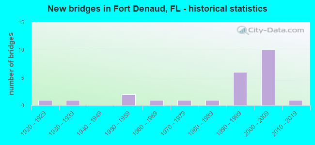
- New bridges - historical statistics
- 11920-1929
- 11930-1939
- 21950-1959
- 11960-1969
- 11970-1979
- 11980-1989
- 61990-1999
- 102000-2009
- 12010-2019

- Reconstructed bridges - Historical Statistics
- 11950-1959
- 01960-1969
- 01970-1979
- 01980-1989
- 01990-1999
- 02000-2009
- 12010-2019


- Bridge Condition - Deck
- 16.7%Very good
- 66.7%Good
- 16.7%Satisfactory

- Bridge Condition - Superstructure
- 7.7%Very good
- 76.9%Good
- 7.7%Satisfactory
- 7.7%Fair

- Bridge Condition - Substructure
- 7.7%Very good
- 69.2%Good
- 15.4%Satisfactory
- 7.7%Fair

- Bridge Condition - Channel
- 4.8%Very good
- 66.7%Good
- 14.3%Satisfactory
- 4.8%Fair
- 9.5%Poor

- Bridge Condition - Culverts
- 72.7%Good
- 9.1%Satisfactory
- 9.1%Fair
- 9.1%Poor
Find on map >> Show street view
Structure Number: 70013, Location: 2.5MI NORTH OF SR 80 (Lat: 26.744742, Lng: -81.510425), Route carried "on" structure: Alternate County highway 78, Year Built: 1963, Status: Posted for load, Structure Length: 13.25m (43.47ft), Average Daily Traffic: 1,000 (year 2021), Truck Traffic: 15%, Average Future Daily Traffic: 1,250 (year 2041), Design Load: H 20, Features Intersected: CALOOSAHATCHEE RIVER, Facility Carried by Structure: FORT DENAUD BR WAY
Minimum Vertical Clearance: 30+ m (98+ ft), Kilometerpoint: 4.223, Lanes on structure: 2, Owner: County Highway Agency, Approaching Roadway Width: 5.5m (18.0ft), Navigation Control: Yes ( Vertical Clearance: 2.7m (8.9ft), Horizontal Clearance: 24.4m (80.1ft)), Material/Design: Steel, Design/Construction: Movable - Swing, Number Of Spans In Main Unit: 1, Number Of Approach Spans: 5, Length of Maximum Span: 58.2m (190.9ft), Curb-To-Curb Width: 5.5m (18.0ft), Out-to-Out Width: 5.8m (19.0ft)
Condition: Deck: Satisfactory, Superstructure: Fair, Substructure: Fair, Channel: Fair, Operating Rating: 6.6 metric tons, Method Used To Determine Operating Rating: Load Factor (LF), Inventory Rating: 4.0 metric tons, Method Used To Determine Inventory Rating: Load Factor (LF), Structural Evaluation: High priority of corrective action, Deck Geometry: High priority of replacement, Waterway Adequacy: Better than present minimum criteria, Approach Roadway Alignment: Equal to present desirable criteria, Bridge Posting: Required (Relationship of Operating Rating to Maximum Legal Load: > 39.9% below), Designated Inspection Frequency: Every 24 months, Critical Feature Inspection Frequency: Every 12 months, Underwater Inspection Frequency: Every 24 months, Other Special Inspection Frequency: Every 12 months, Inspection Date: May 2021, Critical Feature Inspection Date: May 2021, Underwater Inspection Date: April 2021, Other Special Inspection Date: May 2021, Deck Structure Type: Concrete Precast Panels, Wearing Surface/Protective System: Wearing Surface: Bituminous
Find on map >> Show street view
Structure Number: 70041, Location: 0.8 MILE N of SR-80 (Lat: 26.720889, Lng: -81.518056), Route carried "on" structure: Alternate County highway 78A, Year Built: 1958, Status: Open, Structure Length: 0.85m (2.79ft), Average Daily Traffic: 540 (year 2021), Truck Traffic: 2%, Average Future Daily Traffic: 648 (year 2041), Design Load: H 20, Features Intersected: BANANA BRANCH
Minimum Vertical Clearance: 30+ m (98+ ft), Kilometerpoint: 1.210, Lanes on structure: 2, Owner: County Highway Agency, Approaching Roadway Width: 6.5m (21.3ft), Material/Design: Concrete, Design/Construction: Culvert, Number Of Spans In Main Unit: 3, Length of Maximum Span: 3.0m (9.8ft)
Condition: Channel: Good, Culverts: Satisfactory, Inventory Rating: 66.3 metric tons, Method Used To Determine Inventory Rating: Load Factor (LF), Structural Evaluation: Equal to present minimum criteria, Waterway Adequacy: Better than present minimum criteria, Approach Roadway Alignment: Equal to present desirable criteria, Designated Inspection Frequency: Every 24 months, Underwater Inspection Frequency: Every 24 months, Inspection Date: June 2021, Underwater Inspection Date: May 2021
Find on map >> Show street view
Structure Number: 70044, Location: 2.6 MILES WEST OF SR-29 (Lat: 26.758864, Lng: -81.471828), Route carried "on" structure: County highway 78, Year Built: 1952, Year Reconstructed: 2017, Status: Open, Structure Length: 0.64m (2.10ft), Average Daily Traffic: 1,020 (year 2021), Truck Traffic: 2%, Average Future Daily Traffic: 1,275 (year 2041), Features Intersected: LABELLE DRAINAGE CANAL
Minimum Vertical Clearance: 30+ m (98+ ft), Kilometerpoint: 12.287, Lanes on structure: 2, Owner: County Highway Agency, Approaching Roadway Width: 10.7m (35.1ft), Material/Design: Concrete, Design/Construction: Culvert, Number Of Spans In Main Unit: 2, Length of Maximum Span: 3.0m (9.8ft)
Condition: Channel: Satisfactory, Culverts: Good, Operating Rating: 88.2 metric tons, Method Used To Determine Operating Rating: Load Factor (LF), Inventory Rating: 52.9 metric tons, Method Used To Determine Inventory Rating: Load Factor (LF), Structural Evaluation: Better than present minimum criteria, Waterway Adequacy: Better than present minimum criteria, Approach Roadway Alignment: Equal to present desirable criteria, Designated Inspection Frequency: Every 24 months, Inspection Date: June 2021
Find on map >> Show street view
Structure Number: 70064, Location: 5.6 mi. W of SR-29 (Lat: 26.713108, Lng: -81.504653), Route carried "on" structure: State highway 80, Year Built: 2002, Status: Open, Structure Length: 2.16m (7.09ft), Average Daily Traffic: 8,700 (year 2021), Truck Traffic: 18%, Average Future Daily Traffic: 15,094 (year 2041), Design Load: HS 20+Mod, Features Intersected: ROBERTS CANAL
Minimum Vertical Clearance: 30.45m (99.90ft), Kilometerpoint: 6.251, Lanes on structure: 2, Base Highway Network: Yes, Owner: State Highway Agency, Approaching Roadway Width: 8.8m (28.9ft), Material/Design: Concrete continuous, Design/Construction: Slab, Number Of Spans In Main Unit: 3, Length of Maximum Span: 7.9m (25.9ft), Curb-To-Curb Width: 12.2m (40.0ft), Out-to-Out Width: 13.1m (43.0ft)
Condition: Deck: Good, Superstructure: Good, Substructure: Good, Channel: Good, Operating Rating: 67.7 metric tons, Method Used To Determine Operating Rating: Load Factor (LF), Inventory Rating: 40.6 metric tons, Method Used To Determine Inventory Rating: Load Factor (LF), Structural Evaluation: Better than present minimum criteria, Deck Geometry: Better than present minimum criteria, Waterway Adequacy: Equal to present desirable criteria, Approach Roadway Alignment: Equal to present desirable criteria, Designated Inspection Frequency: Every 24 months, Inspection Date: May 2021, Deck Structure Type: Concrete Cast-file-Place
Find on map >> Show street view
Structure Number: 70065, Location: 5.6 mi. W of SR-29 (Lat: 26.712928, Lng: -81.504436), Route carried "on" structure: State highway 80, Year Built: 2003, Status: Open, Structure Length: 2.16m (7.09ft), Average Daily Traffic: 8,700 (year 2021), Truck Traffic: 18%, Average Future Daily Traffic: 15,094 (year 2041), Design Load: HS 20+Mod, Features Intersected: ROBERTS CANAL
Minimum Vertical Clearance: 30.45m (99.90ft), Kilometerpoint: 6.251, Lanes on structure: 2, Base Highway Network: Yes, Owner: State Highway Agency, Approaching Roadway Width: 8.8m (28.9ft), Material/Design: Concrete continuous, Design/Construction: Slab, Number Of Spans In Main Unit: 3, Length of Maximum Span: 7.9m (25.9ft), Curb-To-Curb Width: 12.2m (40.0ft), Out-to-Out Width: 13.1m (43.0ft)
Condition: Deck: Good, Superstructure: Good, Substructure: Good, Channel: Good, Operating Rating: 66.4 metric tons, Method Used To Determine Operating Rating: Load Factor (LF), Inventory Rating: 39.7 metric tons, Method Used To Determine Inventory Rating: Load Factor (LF), Structural Evaluation: Better than present minimum criteria, Deck Geometry: Better than present minimum criteria, Waterway Adequacy: Superior to present desirable criteria, Approach Roadway Alignment: Equal to present desirable criteria, Designated Inspection Frequency: Every 24 months, Inspection Date: May 2021, Deck Structure Type: Concrete Precast Panels
Find on map >> Show street view
Structure Number: 70066, Location: 9 mi. W of SR-29 (Lat: 26.709689, Lng: -81.558308), Route carried "on" structure: State highway 80, Year Built: 2003, Status: Open, Structure Length: 4.04m (13.25ft), Average Daily Traffic: 8,686 (year 2021), Truck Traffic: 13%, Average Future Daily Traffic: 15,069 (year 2041), Design Load: HS 20+Mod, Features Intersected: TOWNSEND CANAL
Minimum Vertical Clearance: 30+ m (98+ ft), Kilometerpoint: 0.795, Lanes on structure: 2, Base Highway Network: Yes, Owner: State Highway Agency, Approaching Roadway Width: 8.5m (27.9ft), Material/Design: Concrete continuous, Design/Construction: Slab, Number Of Spans In Main Unit: 5, Length of Maximum Span: 8.8m (28.9ft), Curb-To-Curb Width: 12.3m (40.4ft), Out-to-Out Width: 13.2m (43.3ft)
Condition: Deck: Good, Superstructure: Good, Substructure: Good, Channel: Good, Operating Rating: 66.3 metric tons, Method Used To Determine Operating Rating: Load Factor (LF), Inventory Rating: 39.8 metric tons, Method Used To Determine Inventory Rating: Load Factor (LF), Structural Evaluation: Better than present minimum criteria, Deck Geometry: Better than present minimum criteria, Waterway Adequacy: Equal to present desirable criteria, Approach Roadway Alignment: Equal to present desirable criteria, Designated Inspection Frequency: Every 24 months, Underwater Inspection Frequency: Every 24 months, Inspection Date: May 2021, Underwater Inspection Date: April 2021, Deck Structure Type: Concrete Cast-file-Place
Find on map >> Show street view
Structure Number: 70067, Location: 9 Mi. W of SR-29 (Lat: 26.709472, Lng: -81.558253), Route carried "on" structure: State highway 80, Year Built: 2003, Status: Open, Structure Length: 4.04m (13.25ft), Average Daily Traffic: 8,686 (year 2021), Truck Traffic: 13%, Average Future Daily Traffic: 15,069 (year 2041), Design Load: HS 20, Features Intersected: TOWNSEND CANAL
Minimum Vertical Clearance: 30+ m (98+ ft), Kilometerpoint: 0.798, Lanes on structure: 2, Base Highway Network: Yes, Owner: State Highway Agency, Approaching Roadway Width: 9.0m (29.5ft), Material/Design: Concrete continuous, Design/Construction: Slab, Number Of Spans In Main Unit: 5, Length of Maximum Span: 8.8m (28.9ft), Curb-To-Curb Width: 12.2m (40.0ft), Out-to-Out Width: 13.1m (43.0ft)
Condition: Deck: Good, Superstructure: Good, Substructure: Good, Channel: Good, Operating Rating: 66.7 metric tons, Method Used To Determine Operating Rating: Load Factor (LF), Inventory Rating: 40.0 metric tons, Method Used To Determine Inventory Rating: Load Factor (LF), Structural Evaluation: Better than present minimum criteria, Deck Geometry: Better than present minimum criteria, Waterway Adequacy: Equal to present desirable criteria, Approach Roadway Alignment: Equal to present desirable criteria, Designated Inspection Frequency: Every 24 months, Underwater Inspection Frequency: Every 24 months, Inspection Date: May 2021, Underwater Inspection Date: April 2021, Deck Structure Type: Concrete Cast-file-Place
Find on map >> Show street view
Structure Number: 70068, Location: 0.25MI E of CR-78A (Lat: 26.710078, Lng: -81.511919), Route carried "on" structure: State highway 80, Year Built: 2003, Status: Open, Structure Length: 0.64m (2.10ft), Average Daily Traffic: 17,400 (year 2021), Truck Traffic: 18%, Average Future Daily Traffic: 30,189 (year 2041), Design Load: HS 20, Features Intersected: FT. SIMMONS BRANCH
Minimum Vertical Clearance: 30+ m (98+ ft), Kilometerpoint: 5.441, Lanes on structure: 4, Base Highway Network: Yes, Owner: State Highway Agency, Approaching Roadway Width: 17.8m (58.4ft), Material/Design: Concrete, Design/Construction: Culvert, Number Of Spans In Main Unit: 2, Length of Maximum Span: 3.2m (10.5ft)
Condition: Channel: Satisfactory, Culverts: Good, Inventory Rating: 57.2 metric tons, Method Used To Determine Inventory Rating: Load Factor (LF), Structural Evaluation: Better than present minimum criteria, Waterway Adequacy: Equal to present desirable criteria, Approach Roadway Alignment: Equal to present desirable criteria, Designated Inspection Frequency: Every 24 months, Inspection Date: May 2021
Find on map >> Show street view
Structure Number: 74002, Location: 1.7 MILES W OF SR-80 (Lat: 26.742722, Lng: -81.484194), Route carried "on" structure: Alternate County highway 78A, Year Built: 1930, Year Reconstructed: 1955, Status: Posted for load, Structure Length: 0.94m (3.08ft), Average Daily Traffic: 510 (year 2021), Truck Traffic: 5%, Average Future Daily Traffic: 638 (year 2041), Features Intersected: DONNA'S CROSSING
Minimum Vertical Clearance: 30+ m (98+ ft), Kilometerpoint: 2.602, Lanes on structure: 2, Owner: County Highway Agency, Approaching Roadway Width: 5.7m (18.7ft), Material/Design: Concrete, Design/Construction: Arch - Deck, Number Of Spans In Main Unit: 1, Length of Maximum Span: 9.4m (30.8ft), Curb-To-Curb Width: 7.7m (25.3ft), Out-to-Out Width: 8.1m (26.6ft)
Condition: Deck: Good, Superstructure: Good, Substructure: Satisfactory, Channel: Good, Operating Rating: 4.2 metric tons, Method Used To Determine Operating Rating: Load Factor (LF), Inventory Rating: 2.5 metric tons, Method Used To Determine Inventory Rating: Load Factor (LF), Structural Evaluation: High priority of corrective action, Deck Geometry: Meets minimum limits, Waterway Adequacy: Better than present minimum criteria, Approach Roadway Alignment: Equal to present desirable criteria, Bridge Posting: Required (Relationship of Operating Rating to Maximum Legal Load: > 39.9% below), Designated Inspection Frequency: Every 24 months, Other Special Inspection Frequency: Every 12 months, Inspection Date: June 2021, Other Special Inspection Date: June 2021, Deck Structure Type: Concrete Cast-file-Place, Wearing Surface/Protective System: Wearing Surface: Bituminous
Find on map >> Show street view
Structure Number: 74004, Location: 0.8 MILE EAST OF CR-78A (Lat: 26.747000, Lng: -81.495167), Route carried "on" structure: County highway 78, Year Built: 1970, Status: Open, Structure Length: 0.72m (2.36ft), Average Daily Traffic: 1,020 (year 2021), Truck Traffic: 2%, Average Future Daily Traffic: 1,549 (year 2041), Design Load: H 20, Features Intersected: ELEPHANT EAR CANAL
Minimum Vertical Clearance: 30+ m (98+ ft), Kilometerpoint: 9.196, Lanes on structure: 2, Owner: County Highway Agency, Approaching Roadway Width: 6.4m (21.0ft), Skew: 4 degrees, Material/Design: Concrete, Design/Construction: Culvert, Number Of Spans In Main Unit: 2, Length of Maximum Span: 3.6m (11.8ft)
Condition: Channel: Poor, Culverts: Fair, Operating Rating: 33.9 metric tons, Method Used To Determine Operating Rating: Load Factor (LF), Inventory Rating: 20.2 metric tons, Method Used To Determine Inventory Rating: Load Factor (LF), Structural Evaluation: Somewhat better than minimum adequacy, Waterway Adequacy: Better than present minimum criteria, Approach Roadway Alignment: Equal to present desirable criteria, Designated Inspection Frequency: Every 24 months, Other Special Inspection Frequency: Every 12 months, Inspection Date: June 2021, Other Special Inspection Date: June 2021
Find on map >> Show street view
Structure Number: 74023, Location: 0.9 MILE W OF SR-80 (Lat: 26.743122, Lng: -81.472956), Route carried "on" structure: County highway 78A, Year Built: 1989, Status: Open, Structure Length: 0.76m (2.49ft), Average Daily Traffic: 238 (year 2021), Average Future Daily Traffic: 298 (year 2041), Design Load: HS 20, Features Intersected: MATTHEWS CREEK
Minimum Vertical Clearance: 30+ m (98+ ft), Kilometerpoint: 3.716, Lanes on structure: 2, Owner: County Highway Agency, Approaching Roadway Width: 5.5m (18.0ft), Material/Design: Concrete, Design/Construction: Slab, Number Of Spans In Main Unit: 1, Length of Maximum Span: 7.6m (24.9ft), Curb-To-Curb Width: 8.9m (29.2ft), Out-to-Out Width: 9.8m (32.2ft)
Condition: Deck: Good, Superstructure: Good, Substructure: Satisfactory, Channel: Good, Operating Rating: 43.5 metric tons, Method Used To Determine Operating Rating: Load Factor (LF), Inventory Rating: 26.0 metric tons, Method Used To Determine Inventory Rating: Load Factor (LF), Structural Evaluation: Equal to present minimum criteria, Deck Geometry: Equal to present minimum criteria, Waterway Adequacy: Superior to present desirable criteria, Approach Roadway Alignment: Better than present minimum criteria, Designated Inspection Frequency: Every 24 months, Inspection Date: June 2021, Deck Structure Type: Concrete Cast-file-Place, Wearing Surface/Protective System: Wearing Surface: Bituminous
Find on map >> Show street view
Structure Number: 74028, Location: 0.2MI W OF SR-80 (Lat: 26.746853, Lng: -81.464056), Route carried "on" structure: County highway 78A, Year Built: 1991, Status: Open, Structure Length: 0.97m (3.18ft), Average Daily Traffic: 1,080 (year 2021), Truck Traffic: 5%, Average Future Daily Traffic: 1,640 (year 2041), Features Intersected: MARIA'S SLOUGH
Minimum Vertical Clearance: 30+ m (98+ ft), Kilometerpoint: 4.954, Lanes on structure: 2, Owner: County Highway Agency, Approaching Roadway Width: 5.9m (19.4ft), Material/Design: Concrete, Design/Construction: Culvert, Number Of Spans In Main Unit: 3, Length of Maximum Span: 3.3m (10.8ft)
Condition: Channel: Poor, Culverts: Poor, Operating Rating: 87.1 metric tons, Method Used To Determine Operating Rating: Load Factor (LF), Inventory Rating: 52.3 metric tons, Method Used To Determine Inventory Rating: Load Factor (LF), Structural Evaluation: Meets minimum limits, Waterway Adequacy: Better than present minimum criteria, Approach Roadway Alignment: Equal to present desirable criteria, Designated Inspection Frequency: Every 24 months, Underwater Inspection Frequency: Every 12 months, Other Special Inspection Frequency: Every 12 months, Inspection Date: June 2021, Underwater Inspection Date: May 2021, Other Special Inspection Date: June 2021
Find on map >> Show street view
Structure Number: 74029, Location: 2 MILES EAST OF CR-78A (Lat: 26.753369, Lng: -81.482064), Route carried "on" structure: County highway 78, Year Built: 1997, Status: Open, Structure Length: 1.96m (6.43ft), Average Daily Traffic: 1,080 (year 2021), Truck Traffic: 5%, Average Future Daily Traffic: 1,350 (year 2041), Design Load: HS 20, Features Intersected: AUSTIN RELIEF CANAL
Minimum Vertical Clearance: 30+ m (98+ ft), Kilometerpoint: 10.812, Lanes on structure: 2, Owner: County Highway Agency, Approaching Roadway Width: 6.8m (22.3ft), Skew: 4 degrees, Material/Design: Concrete, Design/Construction: Culvert, Number Of Spans In Main Unit: 3, Length of Maximum Span: 6.7m (22.0ft)
Condition: Channel: Good, Culverts: Good, Operating Rating: 43.7 metric tons, Method Used To Determine Operating Rating: Load Factor (LF), Inventory Rating: 26.1 metric tons, Method Used To Determine Inventory Rating: Load Factor (LF), Structural Evaluation: Equal to present minimum criteria, Waterway Adequacy: Better than present minimum criteria, Approach Roadway Alignment: Better than present minimum criteria, Designated Inspection Frequency: Every 24 months, Inspection Date: June 2021
Find on map >> Show street view
Structure Number: 74031, Location: 0.1 MI WEST OF CR-78A (Lat: 26.754300, Lng: -81.481444), Route carried "on" structure: County highway , Year Built: 1996, Status: Open, Structure Length: 1.32m (4.33ft), Average Daily Traffic: 500 (year 2021), Truck Traffic: 2%, Average Future Daily Traffic: 625 (year 2041), Design Load: HS 20, Features Intersected: AUSTIN RELIEF CANAL, Facility Carried by Structure: NORTH RIVER ROAD
Minimum Vertical Clearance: 30+ m (98+ ft), Kilometerpoint: 0.000, Lanes on structure: 2, Owner: County Highway Agency, Approaching Roadway Width: 7.6m (24.9ft), Skew: 2 degrees, Material/Design: Concrete, Design/Construction: Culvert, Number Of Spans In Main Unit: 3, Length of Maximum Span: 4.7m (15.4ft)
Condition: Channel: Good, Culverts: Good, Operating Rating: 70.1 metric tons, Method Used To Determine Operating Rating: Load Factor (LF), Inventory Rating: 42.1 metric tons, Method Used To Determine Inventory Rating: Load Factor (LF), Structural Evaluation: Better than present minimum criteria, Waterway Adequacy: Better than present minimum criteria, Approach Roadway Alignment: Better than present minimum criteria, Designated Inspection Frequency: Every 24 months, Inspection Date: June 2021
Find on map >> Show street view
Structure Number: 74032, Location: 1.7MI E OF CR-78A (Lat: 26.751100, Lng: -81.484022), Route carried "on" structure: County highway , Year Built: 1996, Status: Open, Structure Length: 1.25m (4.10ft), Average Daily Traffic: 101 (year 2021), Truck Traffic: 1%, Average Future Daily Traffic: 126 (year 2041), Design Load: HS 20, Features Intersected: AUSTIN RELIEF CANAL, Facility Carried by Structure: GENDOUGLASMCARTHUR
Minimum Vertical Clearance: 30+ m (98+ ft), Kilometerpoint: 0.000, Lanes on structure: 2, Owner: County Highway Agency, Approaching Roadway Width: 6.4m (21.0ft), Material/Design: Concrete, Design/Construction: Culvert, Number Of Spans In Main Unit: 3, Length of Maximum Span: 4.4m (14.4ft)
Condition: Channel: Good, Culverts: Good, Operating Rating: 75.0 metric tons, Method Used To Determine Operating Rating: Load Factor (LF), Inventory Rating: 45.0 metric tons, Method Used To Determine Inventory Rating: Load Factor (LF), Structural Evaluation: Better than present minimum criteria, Waterway Adequacy: Better than present minimum criteria, Approach Roadway Alignment: Equal to present minimum criteria, Designated Inspection Frequency: Every 24 months, Inspection Date: June 2021
Find on map >> Show street view
Structure Number: 150009, Location: 0.2MI. N OF MAIN STREET (Lat: 27.994039, Lng: -82.688122), Route carried "on" structure: State highway 590, Year Built: 1926, Status: Open, Structure Length: 1.74m (5.71ft), Average Daily Traffic: 9,500 (year 2020), Truck Traffic: 3%, Average Future Daily Traffic: 16,483 (year 2042), Design Load: H 15, Features Intersected: MULLET CREEK, Facility Carried by Structure: PHILIPPE PKWY
Minimum Vertical Clearance: 30+ m (98+ ft), Kilometerpoint: 5.282, Lanes on structure: 2, Owner: City or Municipal Highway Agency, Approaching Roadway Width: 8.1m (26.6ft), Material/Design: Concrete, Design/Construction: Arch - Deck, Number Of Spans In Main Unit: 1, Length of Maximum Span: 17.4m (57.1ft), Curb or Sidewalk Widths: Left: 2.0m (6.6ft), Right: 2.0m (6.6ft), Curb-To-Curb Width: 12.3m (40.4ft), Out-to-Out Width: 17.6m (57.7ft)
Condition: Superstructure: Good, Substructure: Good, Channel: Good, Operating Rating: 36.3 metric tons, Method Used To Determine Operating Rating: Load Testing, Inventory Rating: 20.9 metric tons, Method Used To Determine Inventory Rating: Load Testing, Structural Evaluation: Somewhat better than minimum adequacy, Deck Geometry: Somewhat better than minimum adequacy, Waterway Adequacy: Equal to present desirable criteria, Approach Roadway Alignment: Equal to present minimum criteria, Designated Inspection Frequency: Every 24 months, Inspection Date: April 2021, Wearing Surface/Protective System: Wearing Surface: Other
Find on map >> Show street view
Structure Number: 150221, Location: 1 MILE S OF CENTRAL AVE (Lat: 27.756167, Lng: -82.761044), Route carried "on" structure: State highway 699, Year Built: 1997, Status: Open, Structure Length: 19.83m (65.06ft), Average Daily Traffic: 14,600 (year 2020), Truck Traffic: 3%, Average Future Daily Traffic: 25,331 (year 2042), Design Load: HS 20+Mod, Features Intersected: BLIND PASS
Minimum Vertical Clearance: 30.45m (99.90ft), Kilometerpoint: 6.045, Lanes on structure: 4, Owner: State Highway Agency, Approaching Roadway Width: 23.3m (76.4ft), Skew: 20 degrees, Material/Design: Concrete continuous, Design/Construction: Slab, Number Of Spans In Main Unit: 16, Length of Maximum Span: 12.3m (40.4ft), Curb or Sidewalk Widths: Left: 1.6m (5.2ft), Right: 1.6m (5.2ft), Curb-To-Curb Width: 23.2m (76.1ft), Out-to-Out Width: 27.7m (90.9ft)
Condition: Deck: Satisfactory, Superstructure: Satisfactory, Substructure: Good, Channel: Good, Operating Rating: 40.1 metric tons, Method Used To Determine Operating Rating: Load Factor (LF), Inventory Rating: 24.0 metric tons, Method Used To Determine Inventory Rating: Load Factor (LF), Structural Evaluation: Somewhat better than minimum adequacy, Deck Geometry: Superior to present desirable criteria, Waterway Adequacy: Better than present minimum criteria, Approach Roadway Alignment: Equal to present desirable criteria, Designated Inspection Frequency: Every 24 months, Underwater Inspection Frequency: Every 24 months, Inspection Date: April 2021, Underwater Inspection Date: March 2021, Deck Structure Type: Concrete Cast-file-Place
Find on map >> Show street view
Structure Number: 150223, Location: 3.3MI W OF US-19 (Lat: 27.709258, Lng: -82.726586), Route carried "on" structure: State highway 682, Year Built: 2013, Status: Open, Structure Length: 79.31m (260.20ft), Average Daily Traffic: 19,700 (year 2020), Truck Traffic: 3%, Average Future Daily Traffic: 34,180 (year 2042), Design Load: HL 93, Features Intersected: GULF COAST INTRACOASTAL
Minimum Vertical Clearance: 30+ m (98+ ft), Kilometerpoint: 0.690, Lanes on structure: 4, Toll: On toll road, Owner: State Highway Agency, Approaching Roadway Width: 28.9m (94.8ft), Skew: 30 degrees, Navigation Control: Yes ( Vertical Clearance: 20.2m (66.3ft), Horizontal Clearance: 30.5m (100.1ft)), Material/Design: Prestressed concrete, Design/Construction: Stringer/Multi-beam, Number Of Spans In Main Unit: 18, Length of Maximum Span: 52.7m (172.9ft), Curb or Sidewalk Widths: Left: 0.0m, Right: 3.4m (11.2ft), Curb-To-Curb Width: 28.9m (94.8ft), Out-to-Out Width: 29.5m (96.8ft)
Condition: Deck: Good, Superstructure: Good, Substructure: Good, Channel: Good, Operating Rating: 47.0 metric tons, Method Used To Determine Operating Rating: Load and Resistance Factor (LRFR), Inventory Rating: 33.7 metric tons, Method Used To Determine Inventory Rating: Load and Resistance Factor (LRFR), Structural Evaluation: Better than present minimum criteria, Deck Geometry: Superior to present desirable criteria, Waterway Adequacy: Equal to present desirable criteria, Approach Roadway Alignment: Equal to present desirable criteria, Designated Inspection Frequency: Every 24 months, Underwater Inspection Frequency: Every 24 months, Inspection Date: April 2021, Underwater Inspection Date: March 2021, Deck Structure Type: Concrete Cast-file-Place
Find on map >> Show street view
Structure Number: 150232, Location: 0.25MI N OF DREW ST. (Lat: 27.971992, Lng: -82.728664), Route carried "on" structure: State highway , Year Built: 2005, Status: Open, Structure Length: 4.93m (16.17ft), Average Daily Traffic: 300 (year 2018), Truck Traffic: 1%, Average Future Daily Traffic: 521 (year 2040), Design Load: HS 25 or greater, Features Intersected: POND 4E, Facility Carried by Structure: ACCESS ROAD A
Minimum Vertical Clearance: 30+ m (98+ ft), Kilometerpoint: 0.463, Lanes on structure: 2, Owner: State Highway Agency, Approaching Roadway Width: 9.7m (31.8ft), Skew: 9 degrees, Material/Design: Concrete continuous, Design/Construction: Slab, Number Of Spans In Main Unit: 5, Length of Maximum Span: 10.4m (34.1ft), Curb-To-Curb Width: 10.0m (32.8ft), Out-to-Out Width: 11.0m (36.1ft)
Condition: Deck: Good, Superstructure: Very good, Substructure: Very good, Channel: Very good, Operating Rating: 62.1 metric tons, Method Used To Determine Operating Rating: Load Factor (LF), Inventory Rating: 37.2 metric tons, Method Used To Determine Inventory Rating: Load Factor (LF), Structural Evaluation: Equal to present desirable criteria, Deck Geometry: Better than present minimum criteria, Waterway Adequacy: Equal to present desirable criteria, Approach Roadway Alignment: Equal to present minimum criteria, Designated Inspection Frequency: Every 24 months, Inspection Date: March 2020, Deck Structure Type: Concrete Cast-file-Place
Find on map >> Show street view
Structure Number: 150236, Location: 1.8 MI. S OF US-19A (Lat: 28.156283, Lng: -82.740414), Route carried "on" structure: US 19, Year Built: 1999, Status: Open, Structure Length: 0.98m (3.22ft), Average Daily Traffic: 58,000 (year 2020), Truck Traffic: 4%, Average Future Daily Traffic: 100,630 (year 2042), Design Load: HS 20+Mod, Features Intersected: PINELLAS TRAIL
Minimum Vertical Clearance: 30+ m (98+ ft), Kilometerpoint: 51.526, Lanes on structure: 6, Base Highway Network: Yes, Owner: State Highway Agency, Approaching Roadway Width: 35.3m (115.8ft), Skew: 30 degrees, Material/Design: Concrete, Design/Construction: Culvert, Number Of Spans In Main Unit: 1, Length of Maximum Span: 9.8m (32.2ft)
Condition: Culverts: Good, Inventory Rating: 57.6 metric tons, Method Used To Determine Inventory Rating: Load Factor (LF), Structural Evaluation: Better than present minimum criteria, Approach Roadway Alignment: Equal to present desirable criteria, Designated Inspection Frequency: Every 24 months, Inspection Date: March 2020
Find on map >> Show street view
Structure Number: 150237, Location: 100FT S OF 118TH AVE N (Lat: 27.878833, Lng: -82.675500), Route carried "on" structure: Ramp Interstate 275, Year Built: 2002, Status: Open, Structure Length: 1.40m (4.59ft), Average Daily Traffic: 4,460 (year 2020), Truck Traffic: 4%, Average Future Daily Traffic: 7,738 (year 2042), Design Load: HS 20+Mod, Features Intersected: REFUSE CANAL
Minimum Vertical Clearance: 30+ m (98+ ft), Kilometerpoint: 0.027, Lanes on structure: 4, Owner: State Highway Agency, Approaching Roadway Width: 23.6m (77.4ft), Material/Design: Concrete, Design/Construction: Culvert, Number Of Spans In Main Unit: 4, Length of Maximum Span: 3.0m (9.8ft)
Condition: Channel: Satisfactory, Culverts: Good, Inventory Rating: 67.8 metric tons, Method Used To Determine Inventory Rating: Load Factor (LF), Structural Evaluation: Better than present minimum criteria, Waterway Adequacy: Equal to present minimum criteria, Approach Roadway Alignment: Better than present minimum criteria, Designated Inspection Frequency: Every 24 months, Underwater Inspection Frequency: Every 24 months, Inspection Date: October 2021, Underwater Inspection Date: September 2021
Find on map >> Show street view
Structure Number: 150238, Location: 0.3 MI. EAST OF 118TH AVE (Lat: 27.877125, Lng: -82.671586), Route carried "on" structure: Ramp Interstate 275, Year Built: 2002, Year Reconstructed: 2021, Status: Open, Structure Length: 3.62m (11.88ft), Average Daily Traffic: 14,000 (year 2020), Truck Traffic: 6%, Average Future Daily Traffic: 24,290 (year 2042), Design Load: HS 20+Mod, Features Intersected: 28TH STREET
Minimum Vertical Clearance: 30+ m (98+ ft), Kilometerpoint: 3.924, Lanes on structure: 2, Lanes under structure: 5, Owner: State Highway Agency, Approaching Roadway Width: 9.1m (29.9ft), Material/Design: Prestressed concrete, Design/Construction: Stringer/Multi-beam, Number Of Spans In Main Unit: 1, Length of Maximum Span: 36.2m (118.8ft), Curb-To-Curb Width: 9.1m (29.9ft), Out-to-Out Width: 22.9m (75.1ft)
Condition: Deck: Very good, Superstructure: Good, Substructure: Good, Operating Rating: 57.5 metric tons, Method Used To Determine Operating Rating: Load Factor (LF), Inventory Rating: 35.5 metric tons, Method Used To Determine Inventory Rating: Load Factor (LF), Structural Evaluation: Better than present minimum criteria, Deck Geometry: Meets minimum limits, Underclear: Superior to present desirable criteria, Approach Roadway Alignment: Equal to present desirable criteria, Designated Inspection Frequency: Every 24 months, Inspection Date: October 2021, Deck Structure Type: Concrete Cast-file-Place
Find on map >> Show street view
Structure Number: 150239, Location: 0.3MI EAST OF 118TH AVE. (Lat: 27.877347, Lng: -82.671564), Route carried "on" structure: Ramp Interstate 275, Year Built: 2002, Status: Open, Structure Length: 3.62m (11.88ft), Average Daily Traffic: 14,000 (year 2020), Truck Traffic: 6%, Average Future Daily Traffic: 24,290 (year 2042), Design Load: HS 20+Mod, Features Intersected: 28TH ST
Minimum Vertical Clearance: 30+ m (98+ ft), Kilometerpoint: 3.924, Lanes on structure: 2, Lanes under structure: 5, Owner: State Highway Agency, Approaching Roadway Width: 12.6m (41.3ft), Material/Design: Prestressed concrete, Design/Construction: Stringer/Multi-beam, Number Of Spans In Main Unit: 1, Length of Maximum Span: 36.2m (118.8ft), Curb-To-Curb Width: 12.6m (41.3ft), Out-to-Out Width: 13.5m (44.3ft)
Condition: Deck: Very good, Superstructure: Good, Substructure: Good, Operating Rating: 57.8 metric tons, Method Used To Determine Operating Rating: Load Factor (LF), Inventory Rating: 35.7 metric tons, Method Used To Determine Inventory Rating: Load Factor (LF), Structural Evaluation: Better than present minimum criteria, Deck Geometry: Superior to present desirable criteria, Underclear: Superior to present desirable criteria, Approach Roadway Alignment: Equal to present minimum criteria, Designated Inspection Frequency: Every 24 months, Inspection Date: October 2021, Deck Structure Type: Concrete Cast-file-Place
Find on map >> Show street view
Structure Number: 150242, Location: 0.3MI S OF 118TH AVE (Lat: 27.877281, Lng: -82.672147), Route carried "on" structure: State highway 686A, Year Built: 2002, Status: Open, Structure Length: 0.97m (3.18ft), Average Daily Traffic: 28,000 (year 2020), Truck Traffic: 6%, Average Future Daily Traffic: 48,580 (year 2042), Design Load: HS 20+Mod, Features Intersected: REFUSE CANAL
Minimum Vertical Clearance: 30+ m (98+ ft), Kilometerpoint: 3.880, Lanes on structure: 4, Base Highway Network: Yes, Owner: State Highway Agency, Approaching Roadway Width: 32.1m (105.3ft), Skew: 30 degrees, Material/Design: Concrete, Design/Construction: Culvert, Number Of Spans In Main Unit: 3, Length of Maximum Span: 3.0m (9.8ft)
Condition: Channel: Good, Culverts: Good, Inventory Rating: 53.9 metric tons, Method Used To Determine Inventory Rating: Load Factor (LF), Structural Evaluation: Better than present minimum criteria, Waterway Adequacy: Better than present minimum criteria, Approach Roadway Alignment: Better than present minimum criteria, Designated Inspection Frequency: Every 24 months, Underwater Inspection Frequency: Every 24 months, Inspection Date: October 2021, Underwater Inspection Date: September 2021