Bridge Statistics for Fort Chiswell, Virginia (VA)
Condition, Traffic, Stress, Structural Evaluation, Project Costs
- National Bridge Inventory (NBI) Statistics
- 35Number of bridges
- 328ft / 100mTotal length
- $2,138,000Total costs
- 565,959Total average daily traffic
- 144,443Total average daily truck traffic
- National Bridge Inventory (NBI) Registered Bridges for Fort Chiswell
- No street view available for this location
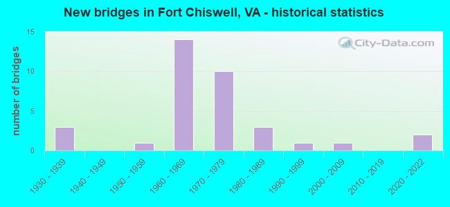
- New bridges - historical statistics
- 31930-1939
- 11950-1959
- 141960-1969
- 101970-1979
- 31980-1989
- 11990-1999
- 12000-2009
- 22020-2022

- Reconstructed bridges - Historical Statistics
- 11950-1959
- 01960-1969
- 31970-1979
- 41980-1989
- 01990-1999
- 02000-2009
- 12010-2019


- Bridge Condition - Deck
- 11.8%Very good
- 23.5%Good
- 41.2%Satisfactory
- 23.5%Fair

- Bridge Condition - Superstructure
- 5.9%Excellent
- 5.9%Very good
- 11.8%Good
- 17.6%Satisfactory
- 52.9%Fair
- 5.9%Poor

- Bridge Condition - Substructure
- 5.9%Very good
- 35.3%Good
- 41.2%Satisfactory
- 17.6%Fair

- Bridge Condition - Channel
- 23.5%Very good
- 5.9%Good
- 29.4%Satisfactory
- 41.2%Fair

- Bridge Condition - Culverts
- 85.7%Satisfactory
- 14.3%Fair
Find on map >> Show street view
Structure Number: 19505, Location: 6.49MTOPULCOL&.65MTO 52 (Lat: 36.946836, Lng: -80.937333), Route carried "on" structure: Interstate 81, Year Built: 1967, Year Reconstructed: 1981, Status: Open, Structure Length: 0.82m (2.69ft), Average Daily Traffic: 45,537 (year 2020), Truck Traffic: 29%, Average Future Daily Traffic: 63,752 (year 2040), Design Load: HS 20, Features Intersected: STREAM
Minimum Vertical Clearance: 30+ m (98+ ft), Kilometerpoint: 130.072, Lanes on structure: 6, Base Highway Network: Yes, Owner: State Highway Agency, Approaching Roadway Width: 54.3m (178.1ft), Skew: 4 degrees, Material/Design: Concrete, Design/Construction: Culvert, Number Of Spans In Main Unit: 3, Length of Maximum Span: 2.7m (8.9ft)
Condition: Channel: Fair, Culverts: Fair, Operating Rating: 44.5 metric tons, Method Used To Determine Operating Rating: Field evaluation and documented engineering judgment, Inventory Rating: 32.7 metric tons, Method Used To Determine Inventory Rating: Field evaluation and documented engineering judgment, Structural Evaluation: Somewhat better than minimum adequacy, Waterway Adequacy: Better than present minimum criteria, Approach Roadway Alignment: Better than present minimum criteria, Designated Inspection Frequency: Every 24 months, Inspection Date: Febuary 2021
Find on map >> Show street view
Structure Number: 19507, Location: .25M TO 613&2.05M TO 121 (Lat: 36.948819, Lng: -80.916111), Route carried "on" structure: ServiceCounty highway F044, Year Built: 1931, Year Reconstructed: 1994, Status: Open, Structure Length: 6.77m (22.21ft), Average Daily Traffic: 1,530 (year 2020), Average Future Daily Traffic: 1,683 (year 2040), Design Load: H 15, Features Intersected: REED CREEK, Facility Carried by Structure: EAST LEE HIGHWAY
Minimum Vertical Clearance: 30+ m (98+ ft), Kilometerpoint: 2.446, Lanes on structure: 2, Owner: State Highway Agency, Approaching Roadway Width: 7.3m (24.0ft), Material/Design: Steel, Design/Construction: Stringer/Multi-beam, Number Of Spans In Main Unit: 3, Length of Maximum Span: 27.4m (89.9ft), Curb-To-Curb Width: 9.1m (29.9ft), Out-to-Out Width: 9.6m (31.5ft)
Condition: Deck: Good, Superstructure: Fair, Substructure: Satisfactory, Channel: Good, Operating Rating: 87.1 metric tons, Method Used To Determine Operating Rating: Load and Resistance Factor (LRFR), Inventory Rating: 67.1 metric tons, Method Used To Determine Inventory Rating: Load and Resistance Factor (LRFR), Structural Evaluation: Somewhat better than minimum adequacy, Deck Geometry: Somewhat better than minimum adequacy, Waterway Adequacy: Better than present minimum criteria, Approach Roadway Alignment: Better than present minimum criteria, Designated Inspection Frequency: Every 24 months, Inspection Date: April 2020, Deck Structure Type: Concrete Cast-file-Place, Wearing Surface/Protective System: Deck Protection: Epoxy Coated Reinforcing
Find on map >> Show street view
Structure Number: 19512, Location: .90MTO 52 & 1.40M TO 613 (Lat: 36.947481, Lng: -80.933125), Route carried "on" structure: Interstate 81, Year Built: 1967, Status: Open, Structure Length: 0.67m (2.20ft), Average Daily Traffic: 45,537 (year 2020), Truck Traffic: 29%, Average Future Daily Traffic: 63,752 (year 2040), Design Load: HS 20, Features Intersected: N&SBL & FO44 OVER STREAM
Minimum Vertical Clearance: 30+ m (98+ ft), Kilometerpoint: 130.474, Lanes on structure: 6, Base Highway Network: Yes, Owner: State Highway Agency, Approaching Roadway Width: 35.7m (117.1ft), Material/Design: Concrete, Design/Construction: Culvert, Number Of Spans In Main Unit: 4, Length of Maximum Span: 1.5m (4.9ft)
Condition: Channel: Fair, Culverts: Satisfactory, Operating Rating: 44.5 metric tons, Method Used To Determine Operating Rating: Field evaluation and documented engineering judgment, Inventory Rating: 32.7 metric tons, Method Used To Determine Inventory Rating: Field evaluation and documented engineering judgment, Structural Evaluation: Equal to present minimum criteria, Waterway Adequacy: Better than present minimum criteria, Approach Roadway Alignment: Better than present minimum criteria, Designated Inspection Frequency: Every 24 months, Inspection Date: Febuary 2021
Find on map >> Show street view
Structure Number: 19513, Location: .0M TO F042 & .0M TO FO43 (Lat: 36.936944, Lng: -80.994397), Route carried "on" structure: ServiceOther road , Year Built: 1985, Status: Open, Structure Length: 7.13m (23.39ft), Average Daily Traffic: 12,286 (year 2017), Average Future Daily Traffic: 17,938 (year 2040), Design Load: HS 20, Features Intersected: I-81 / I-77, Facility Carried by Structure: FRONTAGE ROAD CONN
Minimum Vertical Clearance: 30+ m (98+ ft), Kilometerpoint: 59.420, Lanes on structure: 2, Lanes under structure: 4, Owner: State Highway Agency, Approaching Roadway Width: 11.0m (36.1ft), Material/Design: Steel continuous, Design/Construction: Stringer/Multi-beam, Number Of Spans In Main Unit: 2, Length of Maximum Span: 35.7m (117.1ft), Curb-To-Curb Width: 10.5m (34.4ft), Out-to-Out Width: 11.5m (37.7ft)
Condition: Deck: Satisfactory, Superstructure: Satisfactory, Substructure: Good, Operating Rating: 74.4 metric tons, Method Used To Determine Operating Rating: Load and Resistance Factor (LRFR), Inventory Rating: 57.2 metric tons, Method Used To Determine Inventory Rating: Load and Resistance Factor (LRFR), Structural Evaluation: Equal to present minimum criteria, Deck Geometry: Meets minimum limits, Underclear: Equal to present minimum criteria, Approach Roadway Alignment: Equal to present desirable criteria, Designated Inspection Frequency: Every 24 months, Inspection Date: September 2021, Deck Structure Type: Concrete Cast-file-Place
Find on map >> Show street view
Structure Number: 19539, Location: 0.67 TO 629 & 1.69 TO 627 (Lat: 36.918717, Lng: -80.932239), Route carried "on" structure: US 52, Year Built: 1932, Year Reconstructed: 1950, Status: Posted for load, Structure Length: 0.67m (2.20ft), Average Daily Traffic: 2,623 (year 2020), Truck Traffic: 5%, Average Future Daily Traffic: 2,934 (year 2040), Design Load: H 20, Features Intersected: GLADE CREEK, Facility Carried by Structure: FORT CHISWELL RD.
Minimum Vertical Clearance: 30+ m (98+ ft), Kilometerpoint: 55.697, Lanes on structure: 2, Owner: State Highway Agency, Approaching Roadway Width: 6.7m (22.0ft), Skew: 1 degrees, Material/Design: Concrete, Design/Construction: Slab, Number Of Spans In Main Unit: 1, Length of Maximum Span: 6.1m (20.0ft), Curb or Sidewalk Widths: Left: 0.3m (1.0ft), Right: 0.3m (1.0ft), Curb-To-Curb Width: 10.4m (34.1ft), Out-to-Out Width: 11.0m (36.1ft)
Condition: Deck: Fair, Superstructure: Fair, Substructure: Satisfactory, Channel: Fair, Operating Rating: 23.6 metric tons, Method Used To Determine Operating Rating: Field evaluation and documented engineering judgment, Inventory Rating: 17.2 metric tons, Method Used To Determine Inventory Rating: Field evaluation and documented engineering judgment, Structural Evaluation: Meets minimum limits, Deck Geometry: Somewhat better than minimum adequacy, Waterway Adequacy: Better than present minimum criteria, Approach Roadway Alignment: Better than present minimum criteria, Designated Inspection Frequency: Every 24 months, Inspection Date: March 2021, Bridge Improvement Cost: $80,000, Roadway Improvement Cost: $25,000, Total Project Cost: $136,000 ( Estimate for 2018), Deck Structure Type: Concrete Cast-file-Place, Wearing Surface/Protective System: Wearing Surface: Bituminous
Find on map >> Show street view
Structure Number: 19551, Location: 2.9M TO 94 & 1.20M TO 619 (Lat: 36.899214, Lng: -80.910986), Route carried "on" structure: US 52, Year Built: 1950, Status: Posted for load, Structure Length: 0.70m (2.30ft), Average Daily Traffic: 2,623 (year 2020), Truck Traffic: 5%, Average Future Daily Traffic: 2,934 (year 2040), Design Load: H 20, Features Intersected: GALENA CREEK, Facility Carried by Structure: FORT CHISWELL RD.
Minimum Vertical Clearance: 30+ m (98+ ft), Kilometerpoint: 52.463, Lanes on structure: 2, Base Highway Network: Yes, Owner: State Highway Agency, Approaching Roadway Width: 7.0m (23.0ft), Skew: 3 degrees, Material/Design: Concrete, Design/Construction: Slab, Number Of Spans In Main Unit: 1, Length of Maximum Span: 6.4m (21.0ft), Curb-To-Curb Width: 10.1m (33.1ft), Out-to-Out Width: 10.9m (35.8ft)
Condition: Deck: Fair, Superstructure: Fair, Substructure: Satisfactory, Channel: Fair, Operating Rating: 36.3 metric tons, Method Used To Determine Operating Rating: Load Factor (LF), Inventory Rating: 21.8 metric tons, Method Used To Determine Inventory Rating: Load Factor (LF), Structural Evaluation: Somewhat better than minimum adequacy, Deck Geometry: Meets minimum limits, Waterway Adequacy: Better than present minimum criteria, Approach Roadway Alignment: Better than present minimum criteria, Bridge Posting: Required (Relationship of Operating Rating to Maximum Legal Load: 0.1 - 9.9% below), Length Of Structure Improvement: 0.70m (2.30ft), Designated Inspection Frequency: Every 24 months, Inspection Date: June 2021, Bridge Improvement Cost: $53,000, Roadway Improvement Cost: $10,000, Total Project Cost: $82,000 ( Estimate for 2018), Deck Structure Type: Concrete Cast-file-Place, Wearing Surface/Protective System: Wearing Surface: Bituminous
Find on map >> Show street view
Structure Number: 19557, Location: 0.0M TO 121; 1.23M TO 94 (Lat: 36.945342, Lng: -80.948567), Route carried "on" structure: US 52, Year Built: 1969, Status: Open, Structure Length: 8.73m (28.64ft), Average Daily Traffic: 8,500 (year 2019), Truck Traffic: 4%, Average Future Daily Traffic: 12,750 (year 2039), Design Load: HS 20+Mod, Features Intersected: IS-81/IS-77/US-11;Stream
Minimum Vertical Clearance: 30+ m (98+ ft), Kilometerpoint: 59.190, Lanes on structure: 2, Lanes under structure: 6, Owner: State Highway Agency, Approaching Roadway Width: 7.3m (24.0ft), Skew: 2 degrees, Material/Design: Steel, Design/Construction: Stringer/Multi-beam, Number Of Spans In Main Unit: 5, Length of Maximum Span: 19.8m (65.0ft), Curb or Sidewalk Widths: Left: 0.8m (2.6ft), Right: 0.8m (2.6ft), Curb-To-Curb Width: 9.1m (29.9ft), Out-to-Out Width: 10.7m (35.1ft)
Condition: Deck: Satisfactory, Superstructure: Fair, Substructure: Good, Channel: Very good, Operating Rating: 59.9 metric tons, Method Used To Determine Operating Rating: Load and Resistance Factor (LRFR), Inventory Rating: 46.3 metric tons, Method Used To Determine Inventory Rating: Load and Resistance Factor (LRFR), Structural Evaluation: Somewhat better than minimum adequacy, Deck Geometry: Meets minimum limits, Underclear: High priority of corrective action, Waterway Adequacy: Equal to present desirable criteria, Approach Roadway Alignment: Better than present minimum criteria, Designated Inspection Frequency: Every 24 months, Inspection Date: January 2021, Deck Structure Type: Concrete Cast-file-Place, Wearing Surface/Protective System: Wearing Surface: Latex Concrete, Membrane: Built-up, Deck Protection: Other
Find on map >> Show street view
Structure Number: 19559, Location: 0.0M TO 121; 1.23M TO 94 (Lat: 36.945386, Lng: -80.948325), Route carried "on" structure: US 52, Year Built: 1969, Year Reconstructed: 1993, Status: Open, Structure Length: 8.73m (28.64ft), Average Daily Traffic: 8,500 (year 2019), Truck Traffic: 5%, Average Future Daily Traffic: 12,750 (year 2039), Design Load: HS 20+Mod, Features Intersected: IS-81/IS-77/US-11;Stream
Minimum Vertical Clearance: 30+ m (98+ ft), Kilometerpoint: 59.190, Lanes on structure: 2, Lanes under structure: 6, Owner: State Highway Agency, Approaching Roadway Width: 7.3m (24.0ft), Skew: 2 degrees, Material/Design: Steel, Design/Construction: Stringer/Multi-beam, Number Of Spans In Main Unit: 5, Length of Maximum Span: 19.8m (65.0ft), Curb or Sidewalk Widths: Left: 0.8m (2.6ft), Right: 0.8m (2.6ft), Curb-To-Curb Width: 9.1m (29.9ft), Out-to-Out Width: 10.7m (35.1ft)
Condition: Deck: Satisfactory, Superstructure: Fair, Substructure: Good, Channel: Very good, Operating Rating: 59.9 metric tons, Method Used To Determine Operating Rating: Load and Resistance Factor (LRFR), Inventory Rating: 46.3 metric tons, Method Used To Determine Inventory Rating: Load and Resistance Factor (LRFR), Structural Evaluation: Somewhat better than minimum adequacy, Deck Geometry: Meets minimum limits, Underclear: High priority of corrective action, Waterway Adequacy: Equal to present desirable criteria, Approach Roadway Alignment: Better than present minimum criteria, Designated Inspection Frequency: Every 24 months, Inspection Date: January 2021, Deck Structure Type: Concrete Cast-file-Place, Wearing Surface/Protective System: Wearing Surface: Latex Concrete
Find on map >> Show street view
Structure Number: 19574, Location: 0.0 TO RT 81- 8.11 FR CCL (Lat: 36.947797, Lng: -80.920603), Route carried "on" structure: Interstate 77, Year Built: 1978, Status: Open, Structure Length: 7.99m (26.21ft), Average Daily Traffic: 11,720 (year 2020), Truck Traffic: 24%, Average Future Daily Traffic: 12,892 (year 2040), Design Load: HS 20+Mod, Features Intersected: I-81
Minimum Vertical Clearance: 30+ m (98+ ft), Kilometerpoint: 52.132, Lanes on structure: 2, Lanes under structure: 4, Base Highway Network: Yes, Owner: State Highway Agency, Approaching Roadway Width: 11.6m (38.1ft), Skew: 3 degrees, Material/Design: Steel, Design/Construction: Stringer/Multi-beam, Number Of Spans In Main Unit: 4, Length of Maximum Span: 22.3m (73.2ft), Curb-To-Curb Width: 12.2m (40.0ft), Out-to-Out Width: 13.4m (44.0ft)
Condition: Deck: Good, Superstructure: Good, Substructure: Satisfactory, Operating Rating: 56.2 metric tons, Method Used To Determine Operating Rating: Load and Resistance Factor (LRFR), Inventory Rating: 43.5 metric tons, Method Used To Determine Inventory Rating: Load and Resistance Factor (LRFR), Structural Evaluation: Equal to present minimum criteria, Deck Geometry: Better than present minimum criteria, Underclear: Somewhat better than minimum adequacy, Approach Roadway Alignment: Better than present minimum criteria, Length Of Structure Improvement: 7.92m (25.98ft), Designated Inspection Frequency: Every 24 months, Inspection Date: June 2021, Deck Structure Type: Concrete Cast-file-Place, Wearing Surface/Protective System: Wearing Surface: Epoxy Overlay
Find on map >> Show street view
Structure Number: 19578, Location: 1.56 FR 81-6.72 TO CAR CL (Lat: 36.929783, Lng: -80.910000), Route carried "on" structure: Interstate 77, Year Built: 1978, Status: Open, Structure Length: 3.84m (12.60ft), Average Daily Traffic: 17,408 (year 2020), Truck Traffic: 26%, Average Future Daily Traffic: 24,371 (year 2040), Design Load: HS 20+Mod, Features Intersected: RTE 629
Minimum Vertical Clearance: 30+ m (98+ ft), Kilometerpoint: 49.911, Lanes on structure: 3, Lanes under structure: 2, Base Highway Network: Yes, Owner: State Highway Agency, Approaching Roadway Width: 15.8m (51.8ft), Material/Design: Concrete, Design/Construction: Tee Beam, Number Of Spans In Main Unit: 3, Length of Maximum Span: 13.4m (44.0ft), Curb or Sidewalk Widths: Left: 0.3m (1.0ft), Right: 0.3m (1.0ft), Curb-To-Curb Width: 15.8m (51.8ft), Out-to-Out Width: 17.1m (56.1ft)
Condition: Deck: Satisfactory, Superstructure: Fair, Substructure: Fair, Operating Rating: 75.3 metric tons, Method Used To Determine Operating Rating: Load and Resistance Factor (LRFR), Inventory Rating: 54.4 metric tons, Method Used To Determine Inventory Rating: Load and Resistance Factor (LRFR), Structural Evaluation: Somewhat better than minimum adequacy, Deck Geometry: Somewhat better than minimum adequacy, Underclear: Better than present minimum criteria, Approach Roadway Alignment: Better than present minimum criteria, Length Of Structure Improvement: 5.76m (18.90ft), Designated Inspection Frequency: Every 24 months, Inspection Date: Febuary 2021, Bridge Improvement Cost: $138,000, Roadway Improvement Cost: $10,000, Total Project Cost: $192,000, Deck Structure Type: Concrete Cast-file-Place
Find on map >> Show street view
Structure Number: 1958, Location: 6.73 CAR CL & 1.56 TO 81 (Lat: 36.929989, Lng: -80.909561), Route carried "on" structure: Interstate 77, Year Built: 1978, Status: Open, Structure Length: 4.08m (13.39ft), Average Daily Traffic: 17,445 (year 2020), Truck Traffic: 27%, Average Future Daily Traffic: 24,423 (year 2040), Design Load: HS 20+Mod, Features Intersected: RTE 629
Minimum Vertical Clearance: 30+ m (98+ ft), Kilometerpoint: 49.911, Lanes on structure: 2, Lanes under structure: 2, Base Highway Network: Yes, Owner: State Highway Agency, Approaching Roadway Width: 12.2m (40.0ft), Skew: 1 degrees, Material/Design: Concrete, Design/Construction: Tee Beam, Number Of Spans In Main Unit: 3, Length of Maximum Span: 14.0m (45.9ft), Curb or Sidewalk Widths: Left: 0.3m (1.0ft), Right: 0.3m (1.0ft), Curb-To-Curb Width: 12.2m (40.0ft), Out-to-Out Width: 13.4m (44.0ft)
Condition: Deck: Satisfactory, Superstructure: Fair, Substructure: Fair, Operating Rating: 89.8 metric tons, Method Used To Determine Operating Rating: Load and Resistance Factor (LRFR), Inventory Rating: 68.9 metric tons, Method Used To Determine Inventory Rating: Load and Resistance Factor (LRFR), Structural Evaluation: Somewhat better than minimum adequacy, Deck Geometry: Better than present minimum criteria, Underclear: Equal to present minimum criteria, Approach Roadway Alignment: Better than present minimum criteria, Length Of Structure Improvement: 4.08m (13.39ft), Designated Inspection Frequency: Every 24 months, Inspection Date: Febuary 2021, Bridge Improvement Cost: $101,000, Roadway Improvement Cost: $20,000, Total Project Cost: $157,000, Deck Structure Type: Concrete Cast-file-Place
Find on map >> Show street view
Structure Number: 19584, Location: 3.69 TO NCL & 4.61 TO 81 (Lat: 36.897406, Lng: -80.875214), Route carried "on" structure: Interstate 77, Year Built: 1978, Status: Open, Structure Length: 4.05m (13.29ft), Average Daily Traffic: 17,445 (year 2020), Truck Traffic: 28%, Average Future Daily Traffic: 24,423 (year 2040), Design Load: HS 20+Mod, Features Intersected: RTE 619 MAJOR GRAHAMS RD
Minimum Vertical Clearance: 30+ m (98+ ft), Kilometerpoint: 44.811, Lanes on structure: 2, Lanes under structure: 2, Base Highway Network: Yes, Owner: State Highway Agency, Approaching Roadway Width: 12.2m (40.0ft), Skew: 1 degrees, Material/Design: Concrete, Design/Construction: Tee Beam, Number Of Spans In Main Unit: 3, Length of Maximum Span: 14.3m (46.9ft), Curb or Sidewalk Widths: Left: 0.3m (1.0ft), Right: 0.3m (1.0ft), Curb-To-Curb Width: 12.2m (40.0ft), Out-to-Out Width: 13.4m (44.0ft)
Condition: Deck: Satisfactory, Superstructure: Satisfactory, Substructure: Satisfactory, Operating Rating: 89.8 metric tons, Method Used To Determine Operating Rating: Load and Resistance Factor (LRFR), Inventory Rating: 70.8 metric tons, Method Used To Determine Inventory Rating: Load and Resistance Factor (LRFR), Structural Evaluation: Equal to present minimum criteria, Deck Geometry: Better than present minimum criteria, Underclear: Better than present minimum criteria, Approach Roadway Alignment: Better than present minimum criteria, Length Of Structure Improvement: 4.05m (13.29ft), Designated Inspection Frequency: Every 24 months, Inspection Date: Febuary 2021, Bridge Improvement Cost: $100,000, Roadway Improvement Cost: $20,000, Total Project Cost: $156,000, Deck Structure Type: Concrete Cast-file-Place, Wearing Surface/Protective System: Wearing Surface: Epoxy Overlay
Find on map >> Show street view
Structure Number: 19647, Location: .40M TO750& .40M TO 1009 (Lat: 36.963831, Lng: -80.952231), Route carried "on" structure: State highway 121, Year Built: 1960, Status: Open, Structure Length: 7.68m (25.20ft), Average Daily Traffic: 2,489 (year 2020), Truck Traffic: 4%, Average Future Daily Traffic: 2,835 (year 2040), Design Load: HS 20+Mod, Features Intersected: REED CREEK, Facility Carried by Structure: MAX MEADOWS RD.
Minimum Vertical Clearance: 30+ m (98+ ft), Kilometerpoint: 2.124, Lanes on structure: 2, Owner: State Highway Agency, Approaching Roadway Width: 7.3m (24.0ft), Material/Design: Steel, Design/Construction: Stringer/Multi-beam, Number Of Spans In Main Unit: 4, Length of Maximum Span: 19.5m (64.0ft), Curb or Sidewalk Widths: Left: 0.5m (1.6ft), Right: 0.5m (1.6ft), Curb-To-Curb Width: 7.3m (24.0ft), Out-to-Out Width: 8.8m (28.9ft)
Condition: Deck: Fair, Superstructure: Fair, Substructure: Satisfactory, Channel: Fair, Operating Rating: 45.4 metric tons, Method Used To Determine Operating Rating: Load and Resistance Factor (LRFR), Inventory Rating: 34.5 metric tons, Method Used To Determine Inventory Rating: Load and Resistance Factor (LRFR), Structural Evaluation: Somewhat better than minimum adequacy, Deck Geometry: High priority of replacement, Waterway Adequacy: Better than present minimum criteria, Approach Roadway Alignment: Better than present minimum criteria, Length Of Structure Improvement: 7.68m (25.20ft), Designated Inspection Frequency: Every 24 months, Inspection Date: May 2020, Bridge Improvement Cost: $546,000, Roadway Improvement Cost: $25,000, Total Project Cost: $743,000 ( Estimate for 2018), Deck Structure Type: Concrete Cast-file-Place, Wearing Surface/Protective System: Wearing Surface: Latex Concrete
Find on map >> Show street view
Structure Number: 19673, Location: 3.41M TO 611 & .03M TO 11 (Lat: 36.965214, Lng: -80.851756), Route carried "on" structure: County highway 618, Year Built: 1961, Year Reconstructed: 1986, Status: Open, Structure Length: 6.93m (22.74ft), Average Daily Traffic: 1,580 (year 2016), Average Future Daily Traffic: 1,770 (year 2040), Design Load: HS 20+Mod, Features Intersected: ROUTE 81 / 11, Facility Carried by Structure: PINNACLE DR.
Minimum Vertical Clearance: 30+ m (98+ ft), Kilometerpoint: 1.641, Lanes on structure: 2, Lanes under structure: 4, Owner: State Highway Agency, Approaching Roadway Width: 7.3m (24.0ft), Material/Design: Prestressed concrete, Design/Construction: Stringer/Multi-beam, Number Of Spans In Main Unit: 4, Length of Maximum Span: 18.3m (60.0ft), Curb-To-Curb Width: 7.9m (25.9ft), Out-to-Out Width: 8.6m (28.2ft)
Condition: Deck: Good, Superstructure: Fair, Substructure: Satisfactory, Operating Rating: 66.2 metric tons, Method Used To Determine Operating Rating: Load and Resistance Factor (LRFR), Inventory Rating: 39.9 metric tons, Method Used To Determine Inventory Rating: Load and Resistance Factor (LRFR), Structural Evaluation: Somewhat better than minimum adequacy, Deck Geometry: Meets minimum limits, Underclear: Somewhat better than minimum adequacy, Approach Roadway Alignment: Better than present minimum criteria, Length Of Structure Improvement: 6.92m (22.70ft), Designated Inspection Frequency: Every 24 months, Inspection Date: December 2020, Deck Structure Type: Concrete Cast-file-Place, Wearing Surface/Protective System: Deck Protection: Other Coated Reinforcing
Find on map >> Show street view
Structure Number: 19684, Location: 1.85MTO629 & .01MTO611 (Lat: 36.950150, Lng: -80.881000), Route carried "on" structure: County highway 619, Year Built: 1960, Year Reconstructed: 1993, Status: Posted for load, Structure Length: 6.87m (22.54ft), Average Daily Traffic: 5,644 (year 2020), Truck Traffic: 41%, Average Future Daily Traffic: 6,208 (year 2040), Design Load: HS 20+Mod, Features Intersected: ROUTE 81 / 11
Minimum Vertical Clearance: 30+ m (98+ ft), Kilometerpoint: 43.411, Lanes on structure: 2, Lanes under structure: 4, Owner: State Highway Agency, Approaching Roadway Width: 7.6m (24.9ft), Skew: 1 degrees, Material/Design: Prestressed concrete, Design/Construction: Stringer/Multi-beam, Number Of Spans In Main Unit: 4, Length of Maximum Span: 18.4m (60.4ft), Curb or Sidewalk Widths: Left: 0.5m (1.6ft), Right: 0.5m (1.6ft), Curb-To-Curb Width: 7.3m (24.0ft), Out-to-Out Width: 9.1m (29.9ft)
Condition: Deck: Fair, Superstructure: Poor, Substructure: Fair, Operating Rating: 24.5 metric tons, Method Used To Determine Operating Rating: Load and Resistance Factor (LRFR), Inventory Rating: 10.0 metric tons, Method Used To Determine Inventory Rating: Load and Resistance Factor (LRFR), Structural Evaluation: High priority of corrective action, Deck Geometry: High priority of replacement, Underclear: Equal to present minimum criteria, Approach Roadway Alignment: Better than present minimum criteria, Length Of Structure Improvement: 6.89m (22.60ft), Designated Inspection Frequency: Every 24 months, Other Special Inspection Frequency: Every 12 months, Inspection Date: June 2021, Other Special Inspection Date: June 2021, Bridge Improvement Cost: $492,000, Roadway Improvement Cost: $25,000, Total Project Cost: $672,000 ( Estimate for 2014), Deck Structure Type: Concrete Cast-file-Place, Wearing Surface/Protective System: Wearing Surface: Latex Concrete, Membrane: Built-up, Deck Protection: Other
Find on map >> Show street view
Structure Number: 19696, Location: 1.0M TO 627 & .10M TO 628 (Lat: 36.930733, Lng: -80.900550), Route carried "on" structure: County highway 629, Year Built: 1984, Status: Open, Structure Length: 0.82m (2.69ft), Average Daily Traffic: 718 (year 2017), Average Future Daily Traffic: 977 (year 2040), Design Load: HS 20+Mod, Features Intersected: GLADE CREEK, Facility Carried by Structure: RED HOLLOW RD.
Minimum Vertical Clearance: 30+ m (98+ ft), Kilometerpoint: 3.701, Lanes on structure: 2, Owner: State Highway Agency, Approaching Roadway Width: 6.1m (20.0ft), Skew: 4 degrees, Material/Design: Concrete, Design/Construction: Slab, Number Of Spans In Main Unit: 1, Length of Maximum Span: 7.7m (25.3ft), Curb-To-Curb Width: 7.3m (24.0ft), Out-to-Out Width: 7.9m (25.9ft)
Condition: Deck: Satisfactory, Superstructure: Satisfactory, Substructure: Good, Channel: Satisfactory, Operating Rating: 89.8 metric tons, Method Used To Determine Operating Rating: Load and Resistance Factor (LRFR), Inventory Rating: 88.9 metric tons, Method Used To Determine Inventory Rating: Load and Resistance Factor (LRFR), Structural Evaluation: Equal to present minimum criteria, Deck Geometry: Meets minimum limits, Waterway Adequacy: Better than present minimum criteria, Approach Roadway Alignment: Better than present minimum criteria, Designated Inspection Frequency: Every 24 months, Inspection Date: August 2020, Deck Structure Type: Concrete Cast-file-Place, Wearing Surface/Protective System: Deck Protection: Epoxy Coated Reinforcing
Find on map >> Show street view
Structure Number: 19708, Location: .72 M TO 11 & .1 M TO 720 (Lat: 36.932489, Lng: -81.029178), Route carried "on" structure: County highway 649, Year Built: 1932, Year Reconstructed: 2010, Status: Open, Structure Length: 0.73m (2.40ft), Average Daily Traffic: 614 (year 2017), Average Future Daily Traffic: 685 (year 2040), Design Load: HL 93, Features Intersected: SPILLER BRANCH, Facility Carried by Structure: ATKINS MILL ROAD
Minimum Vertical Clearance: 30+ m (98+ ft), Kilometerpoint: 4.505, Lanes on structure: 1, Owner: State Highway Agency, Approaching Roadway Width: 4.9m (16.1ft), Skew: 4 degrees, Material/Design: Concrete, Design/Construction: Slab, Number Of Spans In Main Unit: 1, Length of Maximum Span: 6.7m (22.0ft), Curb-To-Curb Width: 5.9m (19.4ft), Out-to-Out Width: 6.1m (20.0ft)
Condition: Deck: Good, Superstructure: Good, Substructure: Good, Channel: Satisfactory, Operating Rating: 43.5 metric tons, Method Used To Determine Operating Rating: Load Factor (LF), Inventory Rating: 25.4 metric tons, Method Used To Determine Inventory Rating: Load Factor (LF), Structural Evaluation: Equal to present minimum criteria, Deck Geometry: High priority of replacement, Waterway Adequacy: Better than present minimum criteria, Approach Roadway Alignment: Better than present minimum criteria, Length Of Structure Improvement: 0.79m (2.59ft), Designated Inspection Frequency: Every 24 months, Inspection Date: June 2020, Deck Structure Type: Concrete Precast Panels, Wearing Surface/Protective System: Wearing Surface: Bituminous
Find on map >> Show street view
Structure Number: 25461, Location: .10M TO OLD 94&1.4MTO605 (Lat: 36.891333, Lng: -80.975331), Route carried "on" structure: State highway 94, Year Built: 1999, Status: Open, Structure Length: 0.73m (2.40ft), Average Daily Traffic: 2,973 (year 2020), Truck Traffic: 4%, Average Future Daily Traffic: 4,162 (year 2040), Design Load: HS 20, Features Intersected: STREAM, Facility Carried by Structure: IVANHOE RD.
Minimum Vertical Clearance: 30+ m (98+ ft), Kilometerpoint: 0.000, Lanes on structure: 2, Base Highway Network: Yes, Owner: State Highway Agency, Approaching Roadway Width: 11.3m (37.1ft), Skew: 3 degrees, Material/Design: Concrete, Design/Construction: Culvert, Number Of Spans In Main Unit: 2, Length of Maximum Span: 3.0m (9.8ft)
Condition: Channel: Satisfactory, Culverts: Satisfactory, Operating Rating: 44.5 metric tons, Method Used To Determine Operating Rating: Field evaluation and documented engineering judgment, Inventory Rating: 32.7 metric tons, Method Used To Determine Inventory Rating: Field evaluation and documented engineering judgment, Structural Evaluation: Equal to present minimum criteria, Waterway Adequacy: Better than present minimum criteria, Approach Roadway Alignment: Better than present minimum criteria, Designated Inspection Frequency: Every 24 months, Inspection Date: December 2021
Find on map >> Show street view
Structure Number: 25985, Location: .94 END RTE.&.65M TO 52 (Lat: 36.946567, Lng: -80.937536), Route carried "on" structure: ServiceCounty highway F042, Year Built: 1967, Year Reconstructed: 1981, Status: Open, Structure Length: 0.82m (2.69ft), Average Daily Traffic: 2,132 (year 2020), Average Future Daily Traffic: 2,345 (year 2040), Design Load: HS 20, Features Intersected: STREAM, Facility Carried by Structure: FACTORY OUTLET DR.
Minimum Vertical Clearance: 30+ m (98+ ft), Kilometerpoint: 12.244, Lanes on structure: 2, Owner: State Highway Agency, Approaching Roadway Width: 7.6m (24.9ft), Skew: 4 degrees, Material/Design: Concrete, Design/Construction: Culvert, Number Of Spans In Main Unit: 3, Length of Maximum Span: 2.7m (8.9ft)
Condition: Channel: Fair, Culverts: Satisfactory, Operating Rating: 44.5 metric tons, Method Used To Determine Operating Rating: Field evaluation and documented engineering judgment, Inventory Rating: 32.7 metric tons, Method Used To Determine Inventory Rating: Field evaluation and documented engineering judgment, Structural Evaluation: Equal to present minimum criteria, Waterway Adequacy: Better than present minimum criteria, Approach Roadway Alignment: Better than present minimum criteria, Designated Inspection Frequency: Every 24 months, Inspection Date: Febuary 2021
Find on map >> Show street view
Structure Number: 25986, Location: .65M TO 121 & 1.65M TO613 (Lat: 36.947261, Lng: -80.937058), Route carried "on" structure: ServiceCounty highway F044, Year Built: 1967, Year Reconstructed: 1981, Status: Open, Structure Length: 0.82m (2.69ft), Average Daily Traffic: 1,530 (year 2020), Average Future Daily Traffic: 1,683 (year 2040), Design Load: HS 20, Features Intersected: STREAM, Facility Carried by Structure: EAST LEE HWY.
Minimum Vertical Clearance: 30+ m (98+ ft), Kilometerpoint: 1.046, Lanes on structure: 2, Owner: State Highway Agency, Approaching Roadway Width: 6.7m (22.0ft), Skew: 4 degrees, Material/Design: Concrete, Design/Construction: Culvert, Number Of Spans In Main Unit: 3, Length of Maximum Span: 2.7m (8.9ft)
Condition: Channel: Fair, Culverts: Satisfactory, Operating Rating: 44.5 metric tons, Method Used To Determine Operating Rating: Field evaluation and documented engineering judgment, Inventory Rating: 32.7 metric tons, Method Used To Determine Inventory Rating: Field evaluation and documented engineering judgment, Structural Evaluation: Equal to present minimum criteria, Waterway Adequacy: Better than present minimum criteria, Approach Roadway Alignment: Better than present minimum criteria, Designated Inspection Frequency: Every 24 months, Inspection Date: Febuary 2021
Find on map >> Show street view
Structure Number: 25987, Location: .9M TO 52 & 1.14M TO 613 (Lat: 36.948333, Lng: -80.933369), Route carried "on" structure: ServiceCounty highway F044, Year Built: 1967, Status: Open, Structure Length: 0.67m (2.20ft), Average Daily Traffic: 1,530 (year 2020), Average Future Daily Traffic: 1,683 (year 2040), Design Load: HS 20, Features Intersected: STREAM, Facility Carried by Structure: East Lee Highway
Minimum Vertical Clearance: 30+ m (98+ ft), Kilometerpoint: 1.448, Lanes on structure: 2, Owner: State Highway Agency, Approaching Roadway Width: 6.7m (22.0ft), Material/Design: Concrete, Design/Construction: Culvert, Number Of Spans In Main Unit: 4, Length of Maximum Span: 1.5m (4.9ft)
Condition: Channel: Satisfactory, Culverts: Satisfactory, Operating Rating: 44.5 metric tons, Method Used To Determine Operating Rating: Field evaluation and documented engineering judgment, Inventory Rating: 32.7 metric tons, Method Used To Determine Inventory Rating: Field evaluation and documented engineering judgment, Structural Evaluation: Equal to present minimum criteria, Waterway Adequacy: Better than present minimum criteria, Approach Roadway Alignment: Better than present minimum criteria, Designated Inspection Frequency: Every 24 months, Inspection Date: Febuary 2021
Find on map >> Show street view
Structure Number: 28076, Location: .27M TO 649&.40MTOENDRTE. (Lat: 36.951222, Lng: -81.025058), Route carried "on" structure: County highway 802, Year Built: 2004, Status: Open, Structure Length: 0.94m (3.08ft), Average Daily Traffic: 644 (year 2017), Average Future Daily Traffic: 718 (year 2040), Design Load: HS 20, Features Intersected: REED BRANCH, Facility Carried by Structure: KENTS LN.
Minimum Vertical Clearance: 30+ m (98+ ft), Kilometerpoint: 0.000, Lanes on structure: 2, Owner: State Highway Agency, Approaching Roadway Width: 5.5m (18.0ft), Skew: 1 degrees, Material/Design: Concrete, Design/Construction: Culvert, Number Of Spans In Main Unit: 2, Length of Maximum Span: 4.3m (14.1ft)
Condition: Channel: Satisfactory, Culverts: Satisfactory, Operating Rating: 44.5 metric tons, Method Used To Determine Operating Rating: Field evaluation and documented engineering judgment, Inventory Rating: 32.7 metric tons, Method Used To Determine Inventory Rating: Field evaluation and documented engineering judgment, Structural Evaluation: Equal to present minimum criteria, Waterway Adequacy: Equal to present desirable criteria, Approach Roadway Alignment: Equal to present desirable criteria, Designated Inspection Frequency: Every 24 months, Inspection Date: Febuary 2021
Find on map >> Show street view
Structure Number: 30857, Location: 1.11 TO I-77; 1.11 TO 619 (Lat: 36.946569, Lng: -80.900592), Route carried "on" structure: Interstate 81, Year Built: 2021, Status: Open, Structure Length: 9.63m (31.59ft), Average Daily Traffic: 18,077 (year 2020), Truck Traffic: 27%, Average Future Daily Traffic: 25,308 (year 2040), Design Load: HL 93, Features Intersected: REED CREEK
Minimum Vertical Clearance: 30+ m (98+ ft), Kilometerpoint: 133.559, Lanes on structure: 2, Base Highway Network: Yes, Owner: State Highway Agency, Approaching Roadway Width: 19.5m (64.0ft), Material/Design: Steel continuous, Design/Construction: Stringer/Multi-beam, Number Of Spans In Main Unit: 3, Length of Maximum Span: 37.8m (124.0ft), Curb-To-Curb Width: 19.1m (62.7ft), Out-to-Out Width: 20.1m (65.9ft)
Condition: Deck: Very good, Superstructure: Excellent, Substructure: Very good, Channel: Very good, Operating Rating: 78.0 metric tons, Method Used To Determine Operating Rating: Load and Resistance Factor (LRFR), Inventory Rating: 59.9 metric tons, Method Used To Determine Inventory Rating: Load and Resistance Factor (LRFR), Structural Evaluation: Equal to present desirable criteria, Deck Geometry: Superior to present desirable criteria, Waterway Adequacy: Better than present minimum criteria, Approach Roadway Alignment: Equal to present minimum criteria, Designated Inspection Frequency: Every 24 months, Inspection Date: May 2021, Deck Structure Type: Concrete Cast-file-Place, Wearing Surface/Protective System: Wearing Surface: Monolithic Concrete, Deck Protection: Other Coated Reinforcing
Find on map >> Show street view
Structure Number: 30858, Location: 1.11MTOI77&1.11MTO619 (Lat: 36.946739, Lng: -80.900600), Route carried "on" structure: Interstate 81, Year Built: 2021, Status: Open, Structure Length: 9.63m (31.59ft), Average Daily Traffic: 18,014 (year 2020), Truck Traffic: 26%, Average Future Daily Traffic: 25,220 (year 2040), Design Load: HL 93, Features Intersected: REED CREEK
Minimum Vertical Clearance: 30+ m (98+ ft), Kilometerpoint: 134.030, Lanes on structure: 2, Base Highway Network: Yes, Owner: State Highway Agency, Approaching Roadway Width: 19.5m (64.0ft), Material/Design: Steel continuous, Design/Construction: Stringer/Multi-beam, Number Of Spans In Main Unit: 3, Length of Maximum Span: 37.8m (124.0ft), Curb-To-Curb Width: 19.1m (62.7ft), Out-to-Out Width: 20.1m (65.9ft)
Condition: Deck: Very good, Superstructure: Very good, Substructure: Good, Channel: Very good, Operating Rating: 78.0 metric tons, Method Used To Determine Operating Rating: Load and Resistance Factor (LRFR), Inventory Rating: 59.9 metric tons, Method Used To Determine Inventory Rating: Load and Resistance Factor (LRFR), Structural Evaluation: Better than present minimum criteria, Deck Geometry: Superior to present desirable criteria, Waterway Adequacy: Equal to present desirable criteria, Approach Roadway Alignment: Equal to present desirable criteria, Designated Inspection Frequency: Every 24 months, Inspection Date: August 2020, Deck Structure Type: Concrete Cast-file-Place, Wearing Surface/Protective System: Wearing Surface: Monolithic Concrete, Deck Protection: Other Coated Reinforcing
Find on map >> Show street view
Structure Number: 19513, Location: .0M TO F042 & .0M TO FO43 (Lat: 36.936944, Lng: -80.994397), Route carried "under" structure: Interstate 77, Year Built: 1985, Structure Length: 0. m, Average Daily Traffic: 51,000 (year 2020), Truck Traffic: 31%, Features Intersected: I-81 / I-77, Facility Carried by Structure: FRONTAGE ROAD CONN
Minimum Vertical Clearance: 6.48m (21.26ft), Kilometerpoint: 124.724, Lanes on structure: 2, Lanes under structure: 4, Material/Design: Steel continuous, Design/Construction: Stringer/Multi-beam, Length of Maximum Span: 35.7m (117.1ft)
Find on map >> Show street view
Structure Number: 19557, Location: 0.0M TO 121; 1.23M TO 94 (Lat: 36.945342, Lng: -80.948567), Route carried "under" structure: Interstate 81, Year Built: 1969, Structure Length: 0. m, Average Daily Traffic: 52,000 (year 2019), Truck Traffic: 29%, Features Intersected: IS-81/IS-77/US-11;Stream, Facility Carried by Structure: US-52 SBL
Minimum Vertical Clearance: 5.51m (18.08ft), Kilometerpoint: 129.476, Lanes on structure: 2, Lanes under structure: 6, Material/Design: Steel, Design/Construction: Stringer/Multi-beam, Length of Maximum Span: 19.8m (65.0ft)
Find on map >> Show street view
Structure Number: 19559, Location: 0.0M TO 121; 1.23M TO 94 (Lat: 36.945386, Lng: -80.948325), Route carried "under" structure: Interstate 81, Year Built: 1969, Structure Length: 0. m, Average Daily Traffic: 52,000 (year 2019), Truck Traffic: 29%, Features Intersected: IS-81/IS-77/US-11;Stream, Facility Carried by Structure: US-52 NBL
Minimum Vertical Clearance: 5.54m (18.18ft), Kilometerpoint: 11.472, Lanes on structure: 2, Lanes under structure: 6, Material/Design: Steel, Design/Construction: Stringer/Multi-beam, Length of Maximum Span: 19.8m (65.0ft)
Find on map >> Show street view
Structure Number: 19574, Location: 0.0 TO RT 81- 8.11 FR CCL (Lat: 36.947797, Lng: -80.920603), Route carried "under" structure: Interstate 81, Year Built: 1978, Structure Length: 0. m, Average Daily Traffic: 42,000 (year 2019), Truck Traffic: 26%, Features Intersected: I-81, Facility Carried by Structure: I-77 NBL
Minimum Vertical Clearance: 5.82m (19.09ft), Kilometerpoint: 131.600, Lanes on structure: 2, Lanes under structure: 4, Material/Design: Steel, Design/Construction: Stringer/Multi-beam, Length of Maximum Span: 22.3m (73.2ft)
Find on map >> Show street view
Structure Number: 19576, Location: 0.0 TO RT 81-8.11CARROL C (Lat: 36.947914, Lng: -80.921217), Route carried "under" structure: Interstate 81, Year Built: 1978, Structure Length: 0. m, Average Daily Traffic: 42,000 (year 2019), Truck Traffic: 26%, Features Intersected: I-81, Facility Carried by Structure: I-77 SBL
Minimum Vertical Clearance: 5.74m (18.83ft), Kilometerpoint: 131.504, Lanes on structure: 2, Lanes under structure: 4, Material/Design: Steel, Design/Construction: Stringer/Multi-beam, Length of Maximum Span: 21.8m (71.5ft)
Find on map >> Show street view
Structure Number: 19578, Location: 1.56 FR 81-6.72 TO CAR CL (Lat: 36.929783, Lng: -80.910000), Route carried "under" structure: County highway 629, Year Built: 1978, Structure Length: 0. m, Average Daily Traffic: 357 (year 2003), Features Intersected: RTE 629, Facility Carried by Structure: I-77 SBL
Minimum Vertical Clearance: 4.77m (15.65ft), Kilometerpoint: 3.942, Lanes on structure: 3, Lanes under structure: 2, Material/Design: Concrete, Design/Construction: Tee Beam, Length of Maximum Span: 13.4m (44.0ft)
Find on map >> Show street view
Structure Number: 1958, Location: 6.73 CAR CL & 1.56 TO 81 (Lat: 36.929989, Lng: -80.909561), Route carried "under" structure: Interstate 629, Year Built: 1978, Structure Length: 0. m, Average Daily Traffic: 357 (year 2003), Features Intersected: RTE 629, Facility Carried by Structure: I-77 NBL
Minimum Vertical Clearance: 5.05m (16.57ft), Kilometerpoint: 3.942, Lanes on structure: 2, Lanes under structure: 2, Material/Design: Concrete, Design/Construction: Tee Beam, Length of Maximum Span: 14.0m (45.9ft)
Find on map >> Show street view
Structure Number: 19582, Location: 4.61T0 81; 3.68 TO CAR CL (Lat: 36.897331, Lng: -80.875658), Route carried "under" structure: County highway 619, Year Built: 1978, Structure Length: 0. m, Average Daily Traffic: 73 (year 2003), Features Intersected: RTE 619, Facility Carried by Structure: I-77 SBL
Minimum Vertical Clearance: 5.08m (16.67ft), Kilometerpoint: 35.253, Lanes on structure: 2, Lanes under structure: 2, Material/Design: Concrete, Design/Construction: Tee Beam, Length of Maximum Span: 14.3m (46.9ft)
Find on map >> Show street view
Structure Number: 19584, Location: 3.69 TO NCL & 4.61 TO 81 (Lat: 36.897406, Lng: -80.875214), Route carried "under" structure: County highway 619, Year Built: 1978, Structure Length: 0. m, Average Daily Traffic: 73 (year 2003), Features Intersected: RTE 619 MAJOR GRAHAMS RD, Facility Carried by Structure: I-77 NBL
Minimum Vertical Clearance: 5.11m (16.77ft), Kilometerpoint: 35.253, Lanes on structure: 2, Lanes under structure: 2, Material/Design: Concrete, Design/Construction: Tee Beam, Length of Maximum Span: 14.3m (46.9ft)
Find on map >> Show street view
Structure Number: 19673, Location: 3.41M TO 611 & .03M TO 11 (Lat: 36.965214, Lng: -80.851756), Route carried "under" structure: Interstate 81, Year Built: 1961, Structure Length: 0. m, Average Daily Traffic: 37,000 (year 2017), Truck Traffic: 25%, Features Intersected: ROUTE 81 / 11, Facility Carried by Structure: PINNACLE DR.
Minimum Vertical Clearance: 5.13m (16.83ft), Kilometerpoint: 138.374, Lanes on structure: 2, Lanes under structure: 4, Material/Design: Prestressed concrete, Design/Construction: Stringer/Multi-beam, Length of Maximum Span: 18.3m (60.0ft)
Find on map >> Show street view
Structure Number: 19684, Location: 1.85MTO629 & .01MTO611 (Lat: 36.950150, Lng: -80.881000), Route carried "under" structure: Interstate 81, Year Built: 1960, Structure Length: 0. m, Average Daily Traffic: 42,000 (year 2019), Truck Traffic: 26%, Features Intersected: ROUTE 81 / 11, Facility Carried by Structure: ROUTE 619
Minimum Vertical Clearance: 5.41m (17.75ft), Kilometerpoint: 135.172, Lanes on structure: 2, Lanes under structure: 4, Material/Design: Prestressed concrete, Design/Construction: Stringer/Multi-beam, Length of Maximum Span: 18.4m (60.4ft)