Bridge Statistics for Forestville, Ohio (OH)
Condition, Traffic, Stress, Structural Evaluation, Project Costs
- National Bridge Inventory (NBI) Statistics
- 12Number of bridges
- 118ft / 35.6mTotal length
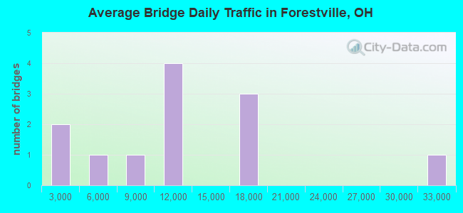
- 137,884Total average daily traffic
- 8,049Total average daily truck traffic
- National Bridge Inventory (NBI) Registered Bridges for Forestville
- No street view available for this location
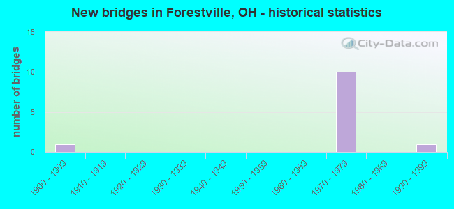
- New bridges - historical statistics
- 11900-1909
- 101970-1979
- 11990-1999
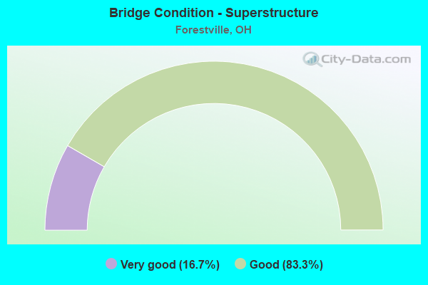
- Bridge Condition - Superstructure
- 16.7%Very good
- 83.3%Good
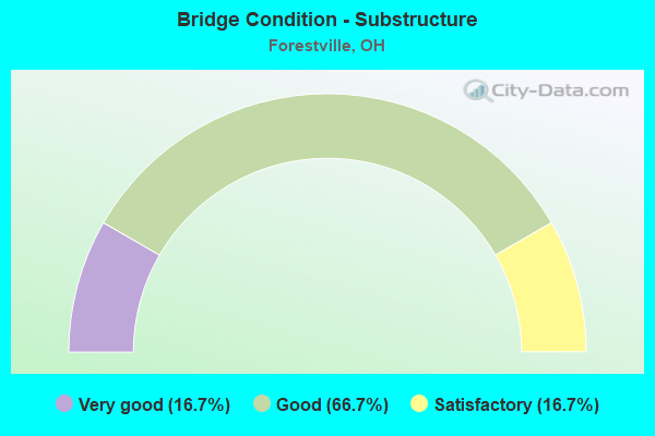
- Bridge Condition - Substructure
- 16.7%Very good
- 66.7%Good
- 16.7%Satisfactory
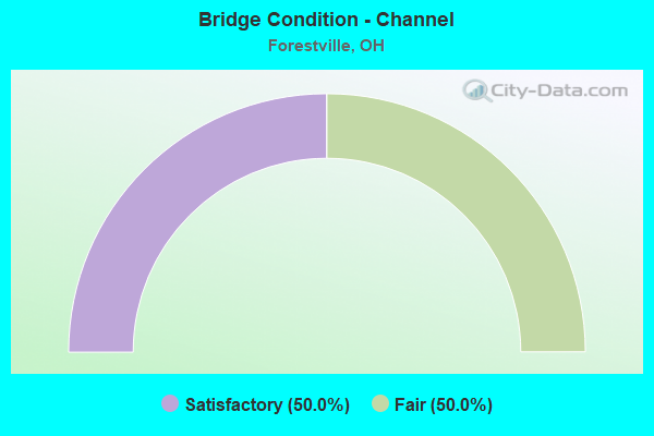
- Bridge Condition - Channel
- 50.0%Satisfactory
- 50.0%Fair
Find on map >> Show street view
Structure Number: 3116735, Location: 3.9 MI E OF IR 71 (Lat: 39.060539, Lng: -84.315231), Route carried "on" structure: Interstate 275, Year Built: 1972, Year Reconstructed: 2006, Status: Open, Structure Length: 3.86m (12.66ft), Average Daily Traffic: 16,463 (year 2018), Truck Traffic: 6%, Average Future Daily Traffic: 22,851 (year 2038), Design Load: HS 20+Mod, Features Intersected: CR 375(NORDYKE ROAD)
Minimum Vertical Clearance: 30+ m (98+ ft), Kilometerpoint: 56.520, Lanes on structure: 3, Lanes under structure: 2, Base Highway Network: Yes (Inventory Route: 2, Subroute: 1), Owner: State Highway Agency, Approaching Roadway Width: 17.1m (56.1ft), Skew: 10 degrees, Material/Design: Prestressed concrete continuous, Design/Construction: Stringer/Multi-beam, Number Of Spans In Main Unit: 3, Length of Maximum Span: 14.6m (47.9ft), Curb-To-Curb Width: 18.9m (62.0ft), Out-to-Out Width: 19.8m (65.0ft)
Condition: Deck: Good, Superstructure: Good, Substructure: Good, Operating Rating: 61.6 metric tons, Method Used To Determine Operating Rating: Load Factor (LF) rating reported by rating factor (RF) method using MS18 loading, Inventory Rating: 35.6 metric tons, Method Used To Determine Inventory Rating: Load Factor (LF) rating reported by rating factor (RF) method using MS18 loading, Structural Evaluation: Better than present minimum criteria, Deck Geometry: Superior to present desirable criteria, Underclear: Equal to present minimum criteria, Approach Roadway Alignment: Superior to present desirable criteria, Designated Inspection Frequency: Every 24 months, Inspection Date: April 2021, Deck Structure Type: Concrete Cast-file-Place, Wearing Surface/Protective System: Wearing Surface: Monolithic Concrete, Deck Protection: Epoxy Coated Reinforcing
Find on map >> Show street view
Structure Number: 3116743, Location: 3.9 MI E OF IR 71 (Lat: 39.060781, Lng: -84.315350), Route carried "on" structure: Interstate 275, Year Built: 1972, Year Reconstructed: 2006, Status: Open, Structure Length: 3.86m (12.66ft), Average Daily Traffic: 16,463 (year 2018), Truck Traffic: 6%, Average Future Daily Traffic: 22,851 (year 2038), Design Load: HS 20+Mod, Features Intersected: CR 375(NORDYKE ROAD)
Minimum Vertical Clearance: 30+ m (98+ ft), Kilometerpoint: 56.520, Lanes on structure: 2, Lanes under structure: 2, Base Highway Network: Yes (Inventory Route: 2, Subroute: 1), Owner: State Highway Agency, Approaching Roadway Width: 17.1m (56.1ft), Skew: 10 degrees, Material/Design: Prestressed concrete continuous, Design/Construction: Stringer/Multi-beam, Number Of Spans In Main Unit: 3, Length of Maximum Span: 14.4m (47.2ft), Curb-To-Curb Width: 18.9m (62.0ft), Out-to-Out Width: 19.8m (65.0ft)
Condition: Deck: Good, Superstructure: Good, Substructure: Good, Operating Rating: 61.6 metric tons, Method Used To Determine Operating Rating: Load Factor (LF) rating reported by rating factor (RF) method using MS18 loading, Inventory Rating: 38.9 metric tons, Method Used To Determine Inventory Rating: Load Factor (LF) rating reported by rating factor (RF) method using MS18 loading, Structural Evaluation: Better than present minimum criteria, Deck Geometry: Superior to present desirable criteria, Underclear: Equal to present minimum criteria, Approach Roadway Alignment: Superior to present desirable criteria, Designated Inspection Frequency: Every 24 months, Inspection Date: April 2021, Deck Structure Type: Concrete Cast-file-Place, Wearing Surface/Protective System: Wearing Surface: Monolithic Concrete, Deck Protection: Epoxy Coated Reinforcing
Find on map >> Show street view
Structure Number: 3116786, Location: 3.7 MI W OF US 52 (Lat: 39.057089, Lng: -84.325289), Route carried "on" structure: County highway C0362, Year Built: 1972, Year Reconstructed: 2006, Status: Open, Structure Length: 9.02m (29.59ft), Average Daily Traffic: 11,913 (year 2018), Truck Traffic: 7%, Average Future Daily Traffic: 45,700 (year 2038), Design Load: HS 20+Mod, Features Intersected: IR 275, Facility Carried by Structure: EIGHT MILE RD C362
Minimum Vertical Clearance: 30+ m (98+ ft), Kilometerpoint: 2.897, Lanes on structure: 2, Lanes under structure: 6, Owner: State Highway Agency, Approaching Roadway Width: 8.5m (27.9ft), Skew: 1 degrees, Material/Design: Steel continuous, Design/Construction: Stringer/Multi-beam, Number Of Spans In Main Unit: 4, Length of Maximum Span: 26.2m (86.0ft), Curb-To-Curb Width: 11.3m (37.1ft), Out-to-Out Width: 12.3m (40.4ft)
Condition: Deck: Good, Superstructure: Good, Substructure: Good, Operating Rating: 42.1 metric tons, Method Used To Determine Operating Rating: Load Factor (LF) rating reported by rating factor (RF) method using MS18 loading, Inventory Rating: 32.4 metric tons, Method Used To Determine Inventory Rating: Load Factor (LF) rating reported by rating factor (RF) method using MS18 loading, Structural Evaluation: Better than present minimum criteria, Deck Geometry: Meets minimum limits, Underclear: High priority of corrective action, Approach Roadway Alignment: Superior to present desirable criteria, Designated Inspection Frequency: Every 24 months, Inspection Date: April 2021, Deck Structure Type: Concrete Cast-file-Place, Wearing Surface/Protective System: Wearing Surface: Monolithic Concrete, Membrane: Epoxy, Deck Protection: Epoxy Coated Reinforcing
Find on map >> Show street view
Structure Number: 3116883, Location: 2.1 MI W OF US 52 (Lat: 39.058989, Lng: -84.354211), Route carried "on" structure: Interstate 275, Year Built: 1973, Year Reconstructed: 2006, Status: Open, Structure Length: 7.19m (23.59ft), Average Daily Traffic: 9,838 (year 2015), Truck Traffic: 6%, Average Future Daily Traffic: 13,655 (year 2035), Design Load: HS 20+Mod, Features Intersected: CR 504(FIVE MILE ROAD)
Minimum Vertical Clearance: 30+ m (98+ ft), Kilometerpoint: 59.996, Lanes on structure: 3, Lanes under structure: 4, Base Highway Network: Yes (Inventory Route: 2, Subroute: 1), Owner: State Highway Agency, Approaching Roadway Width: 18.9m (62.0ft), Skew: 4 degrees, Material/Design: Steel continuous, Design/Construction: Stringer/Multi-beam, Number Of Spans In Main Unit: 3, Length of Maximum Span: 30.5m (100.1ft), Curb-To-Curb Width: 18.9m (62.0ft), Out-to-Out Width: 19.8m (65.0ft)
Condition: Deck: Good, Superstructure: Good, Substructure: Very good, Operating Rating: 48.6 metric tons, Method Used To Determine Operating Rating: Load and Resistance Factor Rating (LRFR) rating reported by rating factor(RF) method using HL-93 loadings, Inventory Rating: 35.6 metric tons, Method Used To Determine Inventory Rating: Load and Resistance Factor Rating (LRFR) rating reported by rating factor(RF) method using HL-93 loadings, Structural Evaluation: Better than present minimum criteria, Deck Geometry: Superior to present desirable criteria, Underclear: Meets minimum limits, Approach Roadway Alignment: Superior to present desirable criteria, Designated Inspection Frequency: Every 24 months, Inspection Date: April 2021, Deck Structure Type: Concrete Cast-file-Place, Wearing Surface/Protective System: Wearing Surface: Monolithic Concrete, Membrane: Epoxy, Deck Protection: Epoxy Coated Reinforcing
Find on map >> Show street view
Structure Number: 3116921, Location: 1.6 MI W OF US 52 (Lat: 39.057181, Lng: -84.363011), Route carried "on" structure: Interstate 275, Year Built: 1973, Status: Open, Structure Length: 10.21m (33.50ft), Average Daily Traffic: 16,569 (year 2015), Truck Traffic: 6%, Average Future Daily Traffic: 22,998 (year 2035), Design Load: HS 20+Mod, Features Intersected: CR 370(MARKLEY ROAD)
Minimum Vertical Clearance: 30+ m (98+ ft), Kilometerpoint: 60.785, Lanes on structure: 2, Lanes under structure: 2, Base Highway Network: Yes (Inventory Route: 2, Subroute: 1), Owner: State Highway Agency, Approaching Roadway Width: 12.2m (40.0ft), Skew: 2 degrees, Material/Design: Steel continuous, Design/Construction: Stringer/Multi-beam, Number Of Spans In Main Unit: 3, Length of Maximum Span: 41.8m (137.1ft), Curb-To-Curb Width: 12.3m (40.4ft), Out-to-Out Width: 13.4m (44.0ft)
Condition: Deck: Good, Superstructure: Very good, Substructure: Good, Operating Rating: 38.9 metric tons, Method Used To Determine Operating Rating: Load and Resistance Factor Rating (LRFR) rating reported by rating factor(RF) method using HL-93 loadings, Inventory Rating: 29.2 metric tons, Method Used To Determine Inventory Rating: Load and Resistance Factor Rating (LRFR) rating reported by rating factor(RF) method using HL-93 loadings, Structural Evaluation: Better than present minimum criteria, Deck Geometry: Better than present minimum criteria, Underclear: Equal to present desirable criteria, Approach Roadway Alignment: Superior to present desirable criteria, Designated Inspection Frequency: Every 24 months, Inspection Date: May 2021, Deck Structure Type: Concrete Cast-file-Place, Wearing Surface/Protective System: Wearing Surface: Integral Concrete
Find on map >> Show street view
Structure Number: 3133117, Location: 1.09 M E of Beechmont (Lat: 39.067019, Lng: -84.339119), Route carried "on" structure: Other road C0386, Year Built: 1900, Status: Open, Structure Length: 0.63m (2.07ft), Average Daily Traffic: 7,165 (year 2015), Truck Traffic: 5%, Average Future Daily Traffic: 9,945 (year 2035), Design Load: HS 20+Mod, Features Intersected: CREEK (FOREST RD), Facility Carried by Structure: FOREST ROAD
Minimum Vertical Clearance: 30+ m (98+ ft), Kilometerpoint: 1.754, Lanes on structure: 2, Owner: County Highway Agency, Approaching Roadway Width: 8.5m (27.9ft), Skew: 3 degrees, Material/Design: Steel, Design/Construction: Culvert, Number Of Spans In Main Unit: 1, Length of Maximum Span: 6.3m (20.7ft)
Condition: Channel: Fair, Culverts: Fair, Operating Rating: 97.2 metric tons, Method Used To Determine Operating Rating: Load Factor (LF) rating reported by rating factor (RF) method using MS18 loading, Inventory Rating: 90.4 metric tons, Method Used To Determine Inventory Rating: Load Factor (LF) rating reported by rating factor (RF) method using MS18 loading, Structural Evaluation: Somewhat better than minimum adequacy, Waterway Adequacy: Equal to present minimum criteria, Approach Roadway Alignment: Equal to present minimum criteria, Designated Inspection Frequency: Every 12 months, Inspection Date: December 2021
Find on map >> Show street view
Structure Number: 3134415, Location: 1100 FT S OF BEECHMONT (Lat: 39.070061, Lng: -84.336250), Route carried "on" structure: County highway C0393, Year Built: 1990, Status: Open, Structure Length: 0.79m (2.59ft), Average Daily Traffic: 2,227 (year 2015), Truck Traffic: 5%, Average Future Daily Traffic: 3,091 (year 2035), Design Load: HS 20+Mod, Features Intersected: CREEK (WITT RD), Facility Carried by Structure: WITT RD
Minimum Vertical Clearance: 30+ m (98+ ft), Kilometerpoint: 0.499, Lanes on structure: 2, Owner: County Highway Agency, Approaching Roadway Width: 7.6m (24.9ft), Skew: 4 degrees, Material/Design: Concrete, Design/Construction: Frame, Number Of Spans In Main Unit: 1, Length of Maximum Span: 7.3m (24.0ft), Curb-To-Curb Width: 8.9m (29.2ft), Out-to-Out Width: 11.0m (36.1ft)
Condition: Deck: Good, Superstructure: Good, Substructure: Satisfactory, Channel: Satisfactory, Operating Rating: 40.8 metric tons, Method Used To Determine Operating Rating: Field evaluation and documented engineering judgment, Inventory Rating: 32.7 metric tons, Method Used To Determine Inventory Rating: Field evaluation and documented engineering judgment, Structural Evaluation: Equal to present minimum criteria, Deck Geometry: Meets minimum limits, Waterway Adequacy: Better than present minimum criteria, Approach Roadway Alignment: Equal to present desirable criteria, Designated Inspection Frequency: Every 12 months, Inspection Date: December 2021, Deck Structure Type: Concrete Cast-file-Place, Wearing Surface/Protective System: Wearing Surface: Bituminous, Membrane: Built-up
Find on map >> Show street view
Structure Number: 3116735, Location: 3.9 MI E OF IR 71 (Lat: 39.060539, Lng: -84.315231), Route carried "under" structure: County highway 375, Year Built: 1972, Structure Length: 0. m, Average Daily Traffic: 9,450 (year 2015), Truck Traffic: 5%, Features Intersected: I275*W, Facility Carried by Structure: NB IR 275
Minimum Vertical Clearance: 4.62m (15.16ft), Kilometerpoint: 3.042, Lanes on structure: 3, Lanes under structure: 2, Material/Design: Prestressed concrete continuous, Design/Construction: Stringer/Multi-beam, Length of Maximum Span: 14.6m (47.9ft)
Find on map >> Show street view
Structure Number: 3116743, Location: 3.9 MI E OF IR 71 (Lat: 39.060781, Lng: -84.315350), Route carried "under" structure: County highway 375, Year Built: 1972, Structure Length: 0. m, Average Daily Traffic: 9,450 (year 2015), Truck Traffic: 5%, Features Intersected: I275*E, Facility Carried by Structure: EB IR 275
Minimum Vertical Clearance: 4.62m (15.16ft), Kilometerpoint: 3.074, Lanes on structure: 2, Lanes under structure: 2, Material/Design: Prestressed concrete continuous, Design/Construction: Stringer/Multi-beam, Length of Maximum Span: 14.4m (47.2ft)
Find on map >> Show street view
Structure Number: 3116786, Location: 3.7 MI W OF US 52 (Lat: 39.057089, Lng: -84.325289), Route carried "under" structure: Interstate 275, Year Built: 1972, Structure Length: 0. m, Average Daily Traffic: 32,925 (year 2015), Truck Traffic: 6%, Features Intersected: CR 362(EIGHT MILE ROAD), Facility Carried by Structure: EIGHT MILE RD C362
Minimum Vertical Clearance: 5.08m (16.67ft), Kilometerpoint: 57.470, Lanes on structure: 2, Lanes under structure: 6, Material/Design: Steel continuous, Design/Construction: Stringer/Multi-beam, Length of Maximum Span: 26.2m (86.0ft)
Find on map >> Show street view
Structure Number: 3116883, Location: 2.1 MI W OF US 52 (Lat: 39.058989, Lng: -84.354211), Route carried "under" structure: County highway 504, Year Built: 1973, Structure Length: 0. m, Average Daily Traffic: 3,194 (year 2015), Truck Traffic: 5%, Features Intersected: I275*E, Facility Carried by Structure: EB IR 275
Minimum Vertical Clearance: 4.37m (14.34ft), Kilometerpoint: 1.014, Lanes on structure: 3, Lanes under structure: 4, Material/Design: Steel continuous, Design/Construction: Stringer/Multi-beam, Length of Maximum Span: 30.5m (100.1ft)
Find on map >> Show street view
Structure Number: 3116921, Location: 1.6 MI W OF US 52 (Lat: 39.057181, Lng: -84.363011), Route carried "under" structure: County highway 370, Year Built: 1973, Structure Length: 0. m, Average Daily Traffic: 2,227 (year 2015), Truck Traffic: 5%, Features Intersected: I275*E, Facility Carried by Structure: EB IR 275
Minimum Vertical Clearance: 7.62m (25.00ft), Kilometerpoint: 0.113, Lanes on structure: 2, Lanes under structure: 2, Material/Design: Steel continuous, Design/Construction: Stringer/Multi-beam, Length of Maximum Span: 41.8m (137.1ft)