Bridge Statistics for Forestburgh, New York (NY)
Condition, Traffic, Stress, Structural Evaluation, Project Costs
- National Bridge Inventory (NBI) Statistics
- 12Number of bridges
- 66ft / 19.7mTotal length
- $9,437,000Total costs
- 4,951Total average daily traffic
- 317Total average daily truck traffic
- 6,148Total future (year 2036) average daily traffic
- National Bridge Inventory (NBI) Registered Bridges for Forestburgh
- No street view available for this location
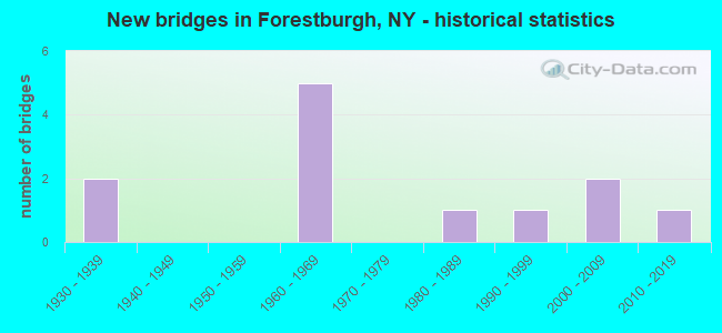
- New bridges - historical statistics
- 21930-1939
- 51960-1969
- 11980-1989
- 11990-1999
- 22000-2009
- 12010-2019

- Bridge Condition - Deck
- 50.0%Very good
- 10.0%Good
- 30.0%Fair
- 10.0%Poor

- Bridge Condition - Superstructure
- 40.0%Very good
- 30.0%Good
- 10.0%Satisfactory
- 20.0%Fair

- Bridge Condition - Substructure
- 40.0%Very good
- 10.0%Good
- 20.0%Satisfactory
- 20.0%Fair
- 10.0%Poor

- Bridge Condition - Channel
- 41.7%Good
- 16.7%Satisfactory
- 41.7%Fair

- Bridge Condition - Culverts
- 50.0%Good
- 50.0%Satisfactory
Find on map >> Show street view
Structure Number: 102498, Location: 7.0 MI S JCT RTS 42 & 17 (Lat: 41.585242, Lng: -74.727094), Route carried "on" structure: State highway 42, Year Built: 1985, Status: Open, Structure Length: 1.01m (3.31ft), Average Daily Traffic: 1,993 (year 2016), Truck Traffic: 8%, Average Future Daily Traffic: 2,005 (year 2040), Design Load: HS 20, Features Intersected: BLACK BROOK
Minimum Vertical Clearance: 30+ m (98+ ft), Kilometerpoint: 10.829, Lanes on structure: 2, Base Highway Network: Yes, Owner: State Highway Agency, Approaching Roadway Width: 12.5m (41.0ft), Skew: 2 degrees, Material/Design: Prestressed concrete, Design/Construction: Box Beam or Girders - Multiple, Number Of Spans In Main Unit: 1, Length of Maximum Span: 9.1m (29.9ft), Curb-To-Curb Width: 12.2m (40.0ft), Out-to-Out Width: 12.8m (42.0ft)
Condition: Deck: Fair, Superstructure: Fair, Substructure: Fair, Channel: Good, Operating Rating: 82.3 metric tons, Method Used To Determine Operating Rating: Load and Resistance Factor Rating (LRFR) rating reported by rating factor(RF) method using HL-93 loadings, Inventory Rating: 63.5 metric tons, Method Used To Determine Inventory Rating: Load and Resistance Factor Rating (LRFR) rating reported by rating factor(RF) method using HL-93 loadings, Structural Evaluation: Somewhat better than minimum adequacy, Deck Geometry: Better than present minimum criteria, Waterway Adequacy: Somewhat better than minimum adequacy, Approach Roadway Alignment: Equal to present desirable criteria, Length Of Structure Improvement: 1.00m (3.28ft), Designated Inspection Frequency: Every 24 months, Inspection Date: June 2021, Bridge Improvement Cost: $487,000, Roadway Improvement Cost: $285,000, Total Project Cost: $772,000 ( Estimate for 2021), Wearing Surface/Protective System: Wearing Surface: Monolithic Concrete
Find on map >> Show street view
Structure Number: 335548, Location: .8 MI NW OF FORESTBURG (Lat: 41.556067, Lng: -74.759925), Route carried "on" structure: County highway , Year Built: 1930, Status: Open, Structure Length: 1.22m (4.00ft), Average Daily Traffic: 954 (year 2017), Truck Traffic: 5%, Average Future Daily Traffic: 1,336 (year 2037), Features Intersected: BLACK BROOK, Facility Carried by Structure: COUNTY ROAD 43
Minimum Vertical Clearance: 30+ m (98+ ft), Kilometerpoint: 6.935, Lanes on structure: 2, Owner: County Highway Agency, Approaching Roadway Width: 6.7m (22.0ft), Material/Design: Steel, Design/Construction: Stringer/Multi-beam, Number Of Spans In Main Unit: 1, Length of Maximum Span: 11.5m (37.7ft), Curb-To-Curb Width: 6.8m (22.3ft), Out-to-Out Width: 7.0m (23.0ft)
Condition: Deck: Fair, Superstructure: Satisfactory, Substructure: Satisfactory, Channel: Fair, Operating Rating: 78.9 metric tons, Method Used To Determine Operating Rating: Load Factor (LF), Inventory Rating: 47.2 metric tons, Method Used To Determine Inventory Rating: Load Factor (LF), Structural Evaluation: Equal to present minimum criteria, Deck Geometry: Meets minimum limits, Waterway Adequacy: Equal to present desirable criteria, Approach Roadway Alignment: Equal to present desirable criteria, Length Of Structure Improvement: 1.21m (3.97ft), Designated Inspection Frequency: Every 24 months, Inspection Date: April 2020, Bridge Improvement Cost: $404,000, Roadway Improvement Cost: $237,000, Total Project Cost: $640,000 ( Estimate for 2021), Deck Structure Type: Concrete Cast-file-Place, Wearing Surface/Protective System: Wearing Surface: Bituminous, Membrane: Other
Find on map >> Show street view
Structure Number: 335549, Location: 2.7 MI NW OF FORESTBURG (Lat: 41.581114, Lng: -74.757111), Route carried "on" structure: County highway , Year Built: 1964, Status: Open, Structure Length: 0.82m (2.69ft), Average Daily Traffic: 252 (year 2019), Truck Traffic: 7%, Average Future Daily Traffic: 353 (year 2039), Design Load: HS 20+Mod, Features Intersected: OUTLET LEES POND, Facility Carried by Structure: SACKETT LAKE ROAD
Minimum Vertical Clearance: 30+ m (98+ ft), Kilometerpoint: 3.202, Lanes on structure: 2, Owner: County Highway Agency, Approaching Roadway Width: 9.1m (29.9ft), Skew: 3 degrees, Material/Design: Concrete, Design/Construction: Culvert, Number Of Spans In Main Unit: 1, Length of Maximum Span: 7.6m (24.9ft), Curb-To-Curb Width: 9.1m (29.9ft), Out-to-Out Width: 11.8m (38.7ft)
Condition: Channel: Satisfactory, Culverts: Good, Operating Rating: 78.0 metric tons, Method Used To Determine Operating Rating: Load Factor (LF), Inventory Rating: 46.3 metric tons, Method Used To Determine Inventory Rating: Load Factor (LF), Structural Evaluation: Better than present minimum criteria, Deck Geometry: Equal to present minimum criteria, Waterway Adequacy: Somewhat better than minimum adequacy, Approach Roadway Alignment: Superior to present desirable criteria, Length Of Structure Improvement: 0.82m (2.69ft), Designated Inspection Frequency: Every 24 months, Inspection Date: October 2021, Bridge Improvement Cost: $171,000, Roadway Improvement Cost: $100,000, Total Project Cost: $272,000 ( Estimate for 2021)
Find on map >> Show street view
Structure Number: 33555, Location: 3 MI NW OF FORESTBURG (Lat: 41.584939, Lng: -74.754869), Route carried "on" structure: County highway , Year Built: 1964, Status: Open, Structure Length: 0.94m (3.08ft), Average Daily Traffic: 252 (year 2019), Truck Traffic: 7%, Average Future Daily Traffic: 353 (year 2039), Features Intersected: RUDICK POND OUTLT, Facility Carried by Structure: SACKETT LAKE ROAD
Minimum Vertical Clearance: 30+ m (98+ ft), Kilometerpoint: 3.701, Lanes on structure: 2, Owner: County Highway Agency, Approaching Roadway Width: 11.0m (36.1ft), Skew: 3 degrees, Material/Design: Steel, Design/Construction: Stringer/Multi-beam, Number Of Spans In Main Unit: 1, Length of Maximum Span: 8.2m (26.9ft), Curb-To-Curb Width: 8.5m (27.9ft), Out-to-Out Width: 9.6m (31.5ft)
Condition: Deck: Fair, Superstructure: Good, Substructure: Good, Channel: Fair, Operating Rating: 64.4 metric tons, Method Used To Determine Operating Rating: Load Factor (LF), Inventory Rating: 38.1 metric tons, Method Used To Determine Inventory Rating: Load Factor (LF), Structural Evaluation: Better than present minimum criteria, Deck Geometry: Equal to present minimum criteria, Waterway Adequacy: Meets minimum limits, Approach Roadway Alignment: Superior to present desirable criteria, Length Of Structure Improvement: 0.94m (3.08ft), Designated Inspection Frequency: Every 24 months, Inspection Date: May 2021, Bridge Improvement Cost: $420,000, Roadway Improvement Cost: $246,000, Total Project Cost: $666,000 ( Estimate for 2021), Deck Structure Type: Concrete Cast-file-Place, Wearing Surface/Protective System: Wearing Surface: Bituminous
Find on map >> Show street view
Structure Number: 335551, Location: AT HARTWOOD (Lat: 41.535728, Lng: -74.684147), Route carried "on" structure: County highway , Year Built: 1963, Status: Open, Structure Length: 1.28m (4.20ft), Average Daily Traffic: 409 (year 2017), Truck Traffic: 6%, Average Future Daily Traffic: 573 (year 2037), Design Load: HS 20+Mod, Features Intersected: BUSH KILL, Facility Carried by Structure: HARTWOOD ROAD
Minimum Vertical Clearance: 30+ m (98+ ft), Kilometerpoint: 5.953, Lanes on structure: 2, Owner: County Highway Agency, Approaching Roadway Width: 9.4m (30.8ft), Skew: 4 degrees, Material/Design: Concrete continuous, Design/Construction: Culvert, Number Of Spans In Main Unit: 2, Length of Maximum Span: 6.0m (19.7ft), Curb-To-Curb Width: 9.2m (30.2ft), Out-to-Out Width: 10.2m (33.5ft)
Condition: Channel: Fair, Culverts: Satisfactory, Operating Rating: 92.5 metric tons, Method Used To Determine Operating Rating: Load Factor (LF), Inventory Rating: 55.3 metric tons, Method Used To Determine Inventory Rating: Load Factor (LF), Structural Evaluation: Equal to present minimum criteria, Deck Geometry: Equal to present minimum criteria, Waterway Adequacy: Somewhat better than minimum adequacy, Approach Roadway Alignment: Superior to present desirable criteria, Length Of Structure Improvement: 1.28m (4.20ft), Designated Inspection Frequency: Every 24 months, Inspection Date: May 2021, Bridge Improvement Cost: $761,000, Roadway Improvement Cost: $446,000, Total Project Cost: $1,207,000 ( Estimate for 2021)
Find on map >> Show street view
Structure Number: 335552, Location: IN OAKLAND VALLEY (Lat: 41.504694, Lng: -74.647831), Route carried "on" structure: County highway , Year Built: 1961, Status: Open, Structure Length: 5.67m (18.60ft), Average Daily Traffic: 577 (year 2016), Truck Traffic: 6%, Average Future Daily Traffic: 808 (year 2036), Features Intersected: NEVERSINK RIVER, Facility Carried by Structure: CR 49
Minimum Vertical Clearance: 30+ m (98+ ft), Kilometerpoint: 0.788, Lanes on structure: 2, Owner: County Highway Agency, Approaching Roadway Width: 7.9m (25.9ft), Material/Design: Prestressed concrete, Design/Construction: Box Beam or Girders - Multiple, Number Of Spans In Main Unit: 3, Length of Maximum Span: 18.5m (60.7ft), Curb or Sidewalk Widths: Left: 0.5m (1.6ft), Right: 0.5m (1.6ft), Curb-To-Curb Width: 7.4m (24.3ft), Out-to-Out Width: 9.1m (29.9ft)
Condition: Deck: Poor, Superstructure: Fair, Substructure: Poor, Channel: Good, Operating Rating: 40.8 metric tons, Method Used To Determine Operating Rating: Load Factor (LF), Inventory Rating: 24.5 metric tons, Method Used To Determine Inventory Rating: Load Factor (LF), Structural Evaluation: Meets minimum limits, Deck Geometry: Meets minimum limits, Waterway Adequacy: Equal to present minimum criteria, Approach Roadway Alignment: Equal to present desirable criteria, Length Of Structure Improvement: 5.66m (18.57ft), Designated Inspection Frequency: Every 24 months, Inspection Date: April 2021, Bridge Improvement Cost: $1,073,000, Roadway Improvement Cost: $628,000, Total Project Cost: $1,701,000 ( Estimate for 2021), Wearing Surface/Protective System: Wearing Surface: Bituminous
Find on map >> Show street view
Structure Number: 335582, Location: 2.3 MI N OF HARTWOOD (Lat: 41.569883, Lng: -74.673722), Route carried "on" structure: County highway , Year Built: 2004, Status: Open, Structure Length: 1.25m (4.10ft), Average Daily Traffic: 289 (year 2017), Truck Traffic: 4%, Average Future Daily Traffic: 405 (year 2037), Design Load: HS 25 or greater, Features Intersected: BUSH KILL, Facility Carried by Structure: BUSH KILL ROAD
Minimum Vertical Clearance: 30+ m (98+ ft), Kilometerpoint: 4.039, Lanes on structure: 2, Owner: County Highway Agency, Approaching Roadway Width: 9.8m (32.2ft), Material/Design: Prestressed concrete, Design/Construction: Box Beam or Girders - Multiple, Number Of Spans In Main Unit: 1, Length of Maximum Span: 12.2m (40.0ft), Curb-To-Curb Width: 9.2m (30.2ft), Out-to-Out Width: 9.8m (32.2ft)
Condition: Deck: Very good, Superstructure: Very good, Substructure: Very good, Channel: Satisfactory, Operating Rating: 78.9 metric tons, Method Used To Determine Operating Rating: Load Factor (LF), Inventory Rating: 47.2 metric tons, Method Used To Determine Inventory Rating: Load Factor (LF), Structural Evaluation: Equal to present desirable criteria, Deck Geometry: Equal to present minimum criteria, Waterway Adequacy: Equal to present desirable criteria, Approach Roadway Alignment: Equal to present desirable criteria, Length Of Structure Improvement: 1.24m (4.07ft), Designated Inspection Frequency: Every 24 months, Inspection Date: March 2020, Bridge Improvement Cost: $560,000, Roadway Improvement Cost: $328,000, Total Project Cost: $888,000 ( Estimate for 2021), Wearing Surface/Protective System: Wearing Surface: Bituminous
Find on map >> Show street view
Structure Number: 335656, Location: IN OAKLAND VALLEY (Lat: 41.505553, Lng: -74.649400), Route carried "on" structure: Other road , Year Built: 2008, Status: Open, Structure Length: 1.28m (4.20ft), Average Daily Traffic: 21 (year 2019), Truck Traffic: 5%, Average Future Daily Traffic: 29 (year 2039), Design Load: HS 25 or greater, Features Intersected: BUSH KILL, Facility Carried by Structure: BURNS ROAD
Minimum Vertical Clearance: 30+ m (98+ ft), Kilometerpoint: 0.531, Lanes on structure: 2, Owner: County Highway Agency, Approaching Roadway Width: 5.5m (18.0ft), Material/Design: Prestressed concrete, Design/Construction: Box Beam or Girders - Multiple, Number Of Spans In Main Unit: 1, Length of Maximum Span: 12.2m (40.0ft), Curb-To-Curb Width: 6.7m (22.0ft), Out-to-Out Width: 7.3m (24.0ft)
Condition: Deck: Very good, Superstructure: Very good, Substructure: Very good, Channel: Good, Inventory Rating: 61.7 metric tons, Method Used To Determine Inventory Rating: Load Factor (LF), Structural Evaluation: Equal to present desirable criteria, Deck Geometry: Somewhat better than minimum adequacy, Waterway Adequacy: Equal to present desirable criteria, Approach Roadway Alignment: Equal to present desirable criteria, Length Of Structure Improvement: 1.28m (4.20ft), Designated Inspection Frequency: Every 24 months, Inspection Date: April 2020, Bridge Improvement Cost: $455,000, Roadway Improvement Cost: $266,000, Total Project Cost: $721,000 ( Estimate for 2021), Wearing Surface/Protective System: Wearing Surface: Bituminous
Find on map >> Show street view
Structure Number: 335657, Location: 0.4 MI W OF FORESTBURG (Lat: 41.546753, Lng: -74.759439), Route carried "on" structure: Other road , Year Built: 2012, Status: Open, Structure Length: 1.10m (3.61ft), Average Daily Traffic: 52 (year 2017), Truck Traffic: 5%, Average Future Daily Traffic: 73 (year 2037), Design Load: HL 93, Features Intersected: BLACK BROOK, Facility Carried by Structure: MILL ROAD
Minimum Vertical Clearance: 30+ m (98+ ft), Kilometerpoint: 0.064, Lanes on structure: 2, Owner: County Highway Agency, Approaching Roadway Width: 6.7m (22.0ft), Skew: 1 degrees, Material/Design: Prestressed concrete, Design/Construction: Box Beam or Girders - Multiple, Number Of Spans In Main Unit: 1, Length of Maximum Span: 9.1m (29.9ft), Curb-To-Curb Width: 6.8m (22.3ft), Out-to-Out Width: 7.4m (24.3ft)
Condition: Deck: Very good, Superstructure: Very good, Substructure: Very good, Channel: Good, Operating Rating: 98.4 metric tons, Method Used To Determine Operating Rating: Load Factor (LF), Inventory Rating: 59.0 metric tons, Method Used To Determine Inventory Rating: Load Factor (LF), Structural Evaluation: Equal to present desirable criteria, Deck Geometry: Somewhat better than minimum adequacy, Waterway Adequacy: Equal to present desirable criteria, Approach Roadway Alignment: Equal to present desirable criteria, Length Of Structure Improvement: 1.09m (3.58ft), Designated Inspection Frequency: Every 24 months, Inspection Date: August 2020, Bridge Improvement Cost: $370,000, Roadway Improvement Cost: $216,000, Total Project Cost: $586,000 ( Estimate for 2021), Wearing Surface/Protective System: Wearing Surface: Bituminous
Find on map >> Show street view
Structure Number: 335659, Location: 1.1 MI SW OF FORESTBURG (Lat: 41.536706, Lng: -74.760619), Route carried "on" structure: Other road , Year Built: 1934, Year Reconstructed: 1968, Status: Open, Structure Length: 1.04m (3.41ft), Average Daily Traffic: 57 (year 2018), Truck Traffic: 4%, Average Future Daily Traffic: 80 (year 2038), Features Intersected: BLACK BROOK, Facility Carried by Structure: PLANK ROAD-SECT A
Minimum Vertical Clearance: 30+ m (98+ ft), Kilometerpoint: 5.133, Lanes on structure: 1, Owner: County Highway Agency, Approaching Roadway Width: 4.9m (16.1ft), Skew: 3 degrees, Material/Design: Wood or Timber, Design/Construction: Slab, Number Of Spans In Main Unit: 1, Length of Maximum Span: 9.4m (30.8ft), Curb-To-Curb Width: 4.9m (16.1ft), Out-to-Out Width: 5.9m (19.4ft)
Condition: Deck: Good, Superstructure: Good, Substructure: Fair, Channel: Fair, Operating Rating: 49.9 metric tons, Method Used To Determine Operating Rating: Load Factor (LF), Inventory Rating: 34.5 metric tons, Method Used To Determine Inventory Rating: Load Factor (LF), Structural Evaluation: Somewhat better than minimum adequacy, Deck Geometry: High priority of corrective action, Waterway Adequacy: Meets minimum limits, Approach Roadway Alignment: Better than present minimum criteria, Length Of Structure Improvement: 1.03m (3.38ft), Designated Inspection Frequency: Every 24 months, Inspection Date: March 2021, Bridge Improvement Cost: $245,000, Roadway Improvement Cost: $143,000, Total Project Cost: $388,000 ( Estimate for 2021), Wearing Surface/Protective System: Wearing Surface: Bituminous
Find on map >> Show street view
Structure Number: 33566, Location: 0.5 MI W OF FORESTBURG (Lat: 41.544558, Lng: -74.760017), Route carried "on" structure: Other road , Year Built: 1999, Status: Open, Structure Length: 1.49m (4.89ft), Average Daily Traffic: 57 (year 2018), Truck Traffic: 4%, Average Future Daily Traffic: 80 (year 2038), Design Load: HS 25 or greater, Features Intersected: BLACK BROOK, Facility Carried by Structure: PLANK ROAD
Minimum Vertical Clearance: 30+ m (98+ ft), Kilometerpoint: 6.195, Lanes on structure: 2, Owner: County Highway Agency, Approaching Roadway Width: 6.7m (22.0ft), Skew: 5 degrees, Material/Design: Prestressed concrete, Design/Construction: Box Beam or Girders - Multiple, Number Of Spans In Main Unit: 1, Length of Maximum Span: 14.0m (45.9ft), Curb-To-Curb Width: 6.8m (22.3ft), Out-to-Out Width: 7.4m (24.3ft)
Condition: Deck: Very good, Superstructure: Very good, Substructure: Very good, Channel: Fair, Operating Rating: 82.6 metric tons, Method Used To Determine Operating Rating: Load Factor (LF), Inventory Rating: 49.0 metric tons, Method Used To Determine Inventory Rating: Load Factor (LF), Structural Evaluation: Equal to present desirable criteria, Deck Geometry: Somewhat better than minimum adequacy, Waterway Adequacy: Meets minimum limits, Approach Roadway Alignment: Equal to present minimum criteria, Length Of Structure Improvement: 1.49m (4.89ft), Designated Inspection Frequency: Every 24 months, Inspection Date: August 2021, Bridge Improvement Cost: $427,000, Roadway Improvement Cost: $250,000, Total Project Cost: $678,000 ( Estimate for 2021), Wearing Surface/Protective System: Wearing Surface: Bituminous
Find on map >> Show street view
Structure Number: 335661, Location: .5 MI NW OF OAKLND VALLEY (Lat: 41.509286, Lng: -74.655164), Route carried "on" structure: Other road , Year Built: 1969, Status: Open, Structure Length: 2.56m (8.40ft), Average Daily Traffic: 38 (year 2018), Truck Traffic: 3%, Average Future Daily Traffic: 53 (year 2038), Design Load: HS 20, Features Intersected: BUSH KILL, Facility Carried by Structure: GALLIGAN ROAD
Minimum Vertical Clearance: 30+ m (98+ ft), Kilometerpoint: 0.821, Lanes on structure: 2, Owner: County Highway Agency, Approaching Roadway Width: 6.1m (20.0ft), Skew: 2 degrees, Material/Design: Steel, Design/Construction: Stringer/Multi-beam, Number Of Spans In Main Unit: 1, Length of Maximum Span: 24.3m (79.7ft), Curb-To-Curb Width: 6.1m (20.0ft), Out-to-Out Width: 6.6m (21.7ft)
Condition: Deck: Very good, Superstructure: Good, Substructure: Satisfactory, Channel: Good, Operating Rating: 77.1 metric tons, Method Used To Determine Operating Rating: Load Factor (LF), Inventory Rating: 46.3 metric tons, Method Used To Determine Inventory Rating: Load Factor (LF), Structural Evaluation: Equal to present minimum criteria, Deck Geometry: Somewhat better than minimum adequacy, Waterway Adequacy: Somewhat better than minimum adequacy, Approach Roadway Alignment: Equal to present desirable criteria, Length Of Structure Improvement: 2.56m (8.40ft), Designated Inspection Frequency: Every 24 months, Inspection Date: April 2021, Bridge Improvement Cost: $579,000, Roadway Improvement Cost: $339,000, Total Project Cost: $918,000 ( Estimate for 2021), Deck Structure Type: Concrete Cast-file-Place, Wearing Surface/Protective System: Wearing Surface: Integral Concrete