Bridge Statistics for Forestbrook, South Carolina (SC)
Condition, Traffic, Stress, Structural Evaluation, Project Costs
- National Bridge Inventory (NBI) Statistics
- 27Number of bridges
- 663ft / 202mTotal length
- 377,865Total average daily traffic
- 29,806Total average daily truck traffic
- National Bridge Inventory (NBI) Registered Bridges for Forestbrook
- No street view available for this location
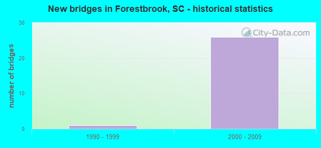
- New bridges - historical statistics
- 11990-1999
- 262000-2009


- Bridge Condition - Deck
- 10.5%Very good
- 89.5%Good

- Bridge Condition - Superstructure
- 63.2%Very good
- 36.8%Good

- Bridge Condition - Substructure
- 57.9%Very good
- 42.1%Good
Find on map >> Show street view
Structure Number: 865, Location: 3.5 MI NE SOCASTEE (Lat: 33.707844, Lng: -78.970869), Route carried "on" structure: State highway 1338, Year Built: 1993, Status: Open, Structure Length: 3.66m (12.01ft), Average Daily Traffic: 1,800 (year 2020), Truck Traffic: 6%, Average Future Daily Traffic: 1,638 (year 2040), Design Load: HS 25 or greater, Features Intersected: SOCASTEE SWAMP
Minimum Vertical Clearance: 30+ m (98+ ft), Kilometerpoint: 2.057, Lanes on structure: 2, Owner: State Highway Agency, Approaching Roadway Width: 7.3m (24.0ft), Material/Design: Concrete continuous, Design/Construction: Slab, Number Of Spans In Main Unit: 4, Length of Maximum Span: 9.1m (29.9ft), Curb-To-Curb Width: 10.4m (34.1ft), Out-to-Out Width: 11.3m (37.1ft)
Condition: Deck: Good, Superstructure: Good, Substructure: Good, Channel: Very good, Operating Rating: 46.3 metric tons, Method Used To Determine Operating Rating: Load and Resistance Factor Rating (LRFR) rating reported by rating factor(RF) method using HL-93 loadings, Inventory Rating: 35.6 metric tons, Method Used To Determine Inventory Rating: Load and Resistance Factor Rating (LRFR) rating reported by rating factor(RF) method using HL-93 loadings, Structural Evaluation: Better than present minimum criteria, Deck Geometry: Equal to present minimum criteria, Waterway Adequacy: Superior to present desirable criteria, Approach Roadway Alignment: Equal to present desirable criteria, Length Of Structure Improvement: 3.66m (12.01ft), Designated Inspection Frequency: Every 24 months, Inspection Date: July 2021, Deck Structure Type: Concrete Precast Panels, Wearing Surface/Protective System: Wearing Surface: Monolithic Concrete
Find on map >> Show street view
Structure Number: 9774, Location: 5.2 MI NE SOCASTEE (Lat: 33.741497, Lng: -78.944158), Route carried "on" structure: State highway 31, Year Built: 2002, Status: Open, Structure Length: 21.95m (72.01ft), Average Daily Traffic: 13,300 (year 2020), Truck Traffic: 7%, Average Future Daily Traffic: 38,437 (year 2040), Design Load: HS 20, Features Intersected: SOCASTEE SWAMP
Minimum Vertical Clearance: 30+ m (98+ ft), Kilometerpoint: 30.795, Lanes on structure: 3, Base Highway Network: Yes, Owner: State Highway Agency, Approaching Roadway Width: 16.5m (54.1ft), Skew: 10 degrees, Material/Design: Prestressed concrete continuous, Design/Construction: Slab, Number Of Spans In Main Unit: 18, Length of Maximum Span: 12.2m (40.0ft), Curb-To-Curb Width: 17.1m (56.1ft), Out-to-Out Width: 18.0m (59.1ft)
Condition: Deck: Good, Superstructure: Good, Substructure: Good, Channel: Very good, Operating Rating: 42.4 metric tons, Method Used To Determine Operating Rating: Load and Resistance Factor Rating (LRFR) rating reported by rating factor(RF) method using HL-93 loadings, Inventory Rating: 24.3 metric tons, Method Used To Determine Inventory Rating: Load and Resistance Factor Rating (LRFR) rating reported by rating factor(RF) method using HL-93 loadings, Structural Evaluation: Equal to present minimum criteria, Deck Geometry: Equal to present minimum criteria, Waterway Adequacy: Equal to present desirable criteria, Approach Roadway Alignment: Equal to present desirable criteria, Length Of Structure Improvement: 21.95m (72.01ft), Designated Inspection Frequency: Every 24 months, Inspection Date: October 2020, Deck Structure Type: Concrete Precast Panels, Wearing Surface/Protective System: Wearing Surface: Monolithic Concrete
Find on map >> Show street view
Structure Number: 9775, Location: 5.2 MI NE SOCASTEE (Lat: 33.741258, Lng: -78.944125), Route carried "on" structure: State highway 31, Year Built: 2002, Status: Open, Structure Length: 21.95m (72.01ft), Average Daily Traffic: 13,300 (year 2020), Truck Traffic: 7%, Average Future Daily Traffic: 38,437 (year 2040), Design Load: HS 25 or greater, Features Intersected: SOCASTEE SWAMP
Minimum Vertical Clearance: 30+ m (98+ ft), Kilometerpoint: 30.788, Lanes on structure: 3, Base Highway Network: Yes, Owner: State Highway Agency, Approaching Roadway Width: 16.5m (54.1ft), Skew: 10 degrees, Material/Design: Prestressed concrete continuous, Design/Construction: Slab, Number Of Spans In Main Unit: 18, Length of Maximum Span: 12.2m (40.0ft), Curb-To-Curb Width: 17.1m (56.1ft), Out-to-Out Width: 18.0m (59.1ft)
Condition: Deck: Good, Superstructure: Good, Substructure: Good, Channel: Very good, Operating Rating: 42.4 metric tons, Method Used To Determine Operating Rating: Load and Resistance Factor Rating (LRFR) rating reported by rating factor(RF) method using HL-93 loadings, Inventory Rating: 24.3 metric tons, Method Used To Determine Inventory Rating: Load and Resistance Factor Rating (LRFR) rating reported by rating factor(RF) method using HL-93 loadings, Structural Evaluation: Equal to present minimum criteria, Deck Geometry: Equal to present minimum criteria, Waterway Adequacy: Equal to present desirable criteria, Approach Roadway Alignment: Equal to present desirable criteria, Length Of Structure Improvement: 21.95m (72.01ft), Designated Inspection Frequency: Every 24 months, Inspection Date: October 2020, Deck Structure Type: Concrete Precast Panels, Wearing Surface/Protective System: Wearing Surface: Monolithic Concrete
Find on map >> Show street view
Structure Number: 9776, Location: 5.5 MI NE SOCASTEE (Lat: 33.742189, Lng: -78.938986), Route carried "on" structure: State highway 31, Year Built: 2002, Status: Open, Structure Length: 5.49m (18.01ft), Average Daily Traffic: 13,300 (year 2020), Truck Traffic: 7%, Average Future Daily Traffic: 38,437 (year 2040), Design Load: HS 20, Features Intersected: L-1390/RONALDMCNAIR BLVD
Minimum Vertical Clearance: 30+ m (98+ ft), Kilometerpoint: 30.409, Lanes on structure: 3, Lanes under structure: 2, Base Highway Network: Yes, Owner: State Highway Agency, Approaching Roadway Width: 16.5m (54.1ft), Skew: 10 degrees, Material/Design: Prestressed concrete continuous, Design/Construction: Stringer/Multi-beam, Number Of Spans In Main Unit: 3, Number Of Approach Spans: 2, Length of Maximum Span: 24.4m (80.1ft), Curb-To-Curb Width: 17.1m (56.1ft), Out-to-Out Width: 18.0m (59.1ft)
Condition: Deck: Very good, Superstructure: Very good, Substructure: Very good, Operating Rating: 71.9 metric tons, Method Used To Determine Operating Rating: Load and Resistance Factor Rating (LRFR) rating reported by rating factor(RF) method using HL-93 loadings, Inventory Rating: 55.4 metric tons, Method Used To Determine Inventory Rating: Load and Resistance Factor Rating (LRFR) rating reported by rating factor(RF) method using HL-93 loadings, Structural Evaluation: Equal to present desirable criteria, Deck Geometry: Equal to present minimum criteria, Underclear: Superior to present desirable criteria, Approach Roadway Alignment: Equal to present desirable criteria, Length Of Structure Improvement: 5.49m (18.01ft), Designated Inspection Frequency: Every 24 months, Inspection Date: October 2020, Deck Structure Type: Concrete Cast-file-Place, Wearing Surface/Protective System: Wearing Surface: Monolithic Concrete
Find on map >> Show street view
Structure Number: 9777, Location: 5.5 MI NE SOCASTEE (Lat: 33.741978, Lng: -78.938956), Route carried "on" structure: State highway 31, Year Built: 2002, Status: Open, Structure Length: 5.49m (18.01ft), Average Daily Traffic: 13,300 (year 2020), Truck Traffic: 7%, Average Future Daily Traffic: 38,437 (year 2040), Design Load: HS 20, Features Intersected: L-1390/RONALDMCNAIR BLVD
Minimum Vertical Clearance: 30+ m (98+ ft), Kilometerpoint: 30.399, Lanes on structure: 3, Lanes under structure: 2, Base Highway Network: Yes, Owner: State Highway Agency, Approaching Roadway Width: 16.5m (54.1ft), Skew: 10 degrees, Material/Design: Prestressed concrete continuous, Design/Construction: Stringer/Multi-beam, Number Of Spans In Main Unit: 3, Number Of Approach Spans: 2, Length of Maximum Span: 24.4m (80.1ft), Curb-To-Curb Width: 17.1m (56.1ft), Out-to-Out Width: 18.0m (59.1ft)
Condition: Deck: Good, Superstructure: Very good, Substructure: Very good, Operating Rating: 72.3 metric tons, Method Used To Determine Operating Rating: Load and Resistance Factor Rating (LRFR) rating reported by rating factor(RF) method using HL-93 loadings, Inventory Rating: 55.7 metric tons, Method Used To Determine Inventory Rating: Load and Resistance Factor Rating (LRFR) rating reported by rating factor(RF) method using HL-93 loadings, Structural Evaluation: Equal to present desirable criteria, Deck Geometry: Equal to present minimum criteria, Underclear: Superior to present desirable criteria, Approach Roadway Alignment: Equal to present desirable criteria, Length Of Structure Improvement: 5.49m (18.01ft), Designated Inspection Frequency: Every 24 months, Inspection Date: October 2020, Deck Structure Type: Concrete Cast-file-Place, Wearing Surface/Protective System: Wearing Surface: Monolithic Concrete
Find on map >> Show street view
Structure Number: 9778, Location: 5.65 MI NE SOCASTEE (Lat: 33.742444, Lng: -78.936403), Route carried "on" structure: State highway 31, Year Built: 2002, Status: Open, Structure Length: 4.72m (15.49ft), Average Daily Traffic: 13,300 (year 2020), Truck Traffic: 7%, Average Future Daily Traffic: 38,437 (year 2040), Design Load: HS 20, Features Intersected: HORRY CO. RR
Minimum Vertical Clearance: 30+ m (98+ ft), Kilometerpoint: 30.167, Lanes on structure: 3, Base Highway Network: Yes, Owner: State Highway Agency, Approaching Roadway Width: 13.7m (44.9ft), Skew: 13 degrees, Material/Design: Prestressed concrete, Design/Construction: Stringer/Multi-beam, Number Of Spans In Main Unit: 1, Length of Maximum Span: 45.7m (149.9ft), Curb-To-Curb Width: 17.1m (56.1ft), Out-to-Out Width: 18.0m (59.1ft)
Condition: Deck: Good, Superstructure: Very good, Substructure: Good, Operating Rating: 71.0 metric tons, Method Used To Determine Operating Rating: Load and Resistance Factor Rating (LRFR) rating reported by rating factor(RF) method using HL-93 loadings, Inventory Rating: 39.9 metric tons, Method Used To Determine Inventory Rating: Load and Resistance Factor Rating (LRFR) rating reported by rating factor(RF) method using HL-93 loadings, Structural Evaluation: Better than present minimum criteria, Deck Geometry: Equal to present minimum criteria, Underclear: Superior to present desirable criteria, Approach Roadway Alignment: Equal to present desirable criteria, Length Of Structure Improvement: 4.72m (15.49ft), Designated Inspection Frequency: Every 24 months, Inspection Date: October 2020, Deck Structure Type: Concrete Cast-file-Place, Wearing Surface/Protective System: Wearing Surface: Monolithic Concrete
Find on map >> Show street view
Structure Number: 9779, Location: 5.65 MI NE SOCASTEE (Lat: 33.742225, Lng: -78.936147), Route carried "on" structure: State highway 31, Year Built: 2002, Status: Open, Structure Length: 4.72m (15.49ft), Average Daily Traffic: 13,300 (year 2020), Truck Traffic: 7%, Average Future Daily Traffic: 38,437 (year 2040), Design Load: HS 20, Features Intersected: HORRY CO. RR
Minimum Vertical Clearance: 30+ m (98+ ft), Kilometerpoint: 30.172, Lanes on structure: 3, Base Highway Network: Yes, Owner: State Highway Agency, Approaching Roadway Width: 14.0m (45.9ft), Skew: 13 degrees, Material/Design: Prestressed concrete, Design/Construction: Stringer/Multi-beam, Number Of Spans In Main Unit: 1, Length of Maximum Span: 47.2m (154.9ft), Curb-To-Curb Width: 17.1m (56.1ft), Out-to-Out Width: 18.0m (59.1ft)
Condition: Deck: Good, Superstructure: Very good, Substructure: Good, Operating Rating: 71.0 metric tons, Method Used To Determine Operating Rating: Load and Resistance Factor Rating (LRFR) rating reported by rating factor(RF) method using HL-93 loadings, Inventory Rating: 39.9 metric tons, Method Used To Determine Inventory Rating: Load and Resistance Factor Rating (LRFR) rating reported by rating factor(RF) method using HL-93 loadings, Structural Evaluation: Better than present minimum criteria, Deck Geometry: Equal to present minimum criteria, Underclear: Superior to present desirable criteria, Approach Roadway Alignment: Equal to present desirable criteria, Length Of Structure Improvement: 4.72m (15.49ft), Designated Inspection Frequency: Every 24 months, Inspection Date: October 2020, Deck Structure Type: Concrete Cast-file-Place, Wearing Surface/Protective System: Wearing Surface: Monolithic Concrete
Find on map >> Show street view
Structure Number: 9879, Location: 4 MI N. OF MYRTLE BEACH (Lat: 33.732597, Lng: -78.944333), Route carried "on" structure: US 501, Year Built: 2004, Status: Open, Structure Length: 30.93m (101.48ft), Average Daily Traffic: 27,950 (year 2020), Truck Traffic: 11%, Average Future Daily Traffic: 34,938 (year 2040), Design Load: HS 20, Features Intersected: FOREST BROOK RD
Minimum Vertical Clearance: 7.26m (23.82ft), Kilometerpoint: 46.824, Lanes on structure: 2, Lanes under structure: 3, Base Highway Network: Yes, Owner: State Highway Agency, Approaching Roadway Width: 20.1m (65.9ft), Skew: 31 degrees, Material/Design: Steel continuous, Design/Construction: Stringer/Multi-beam, Number Of Spans In Main Unit: 5, Length of Maximum Span: 89.6m (294.0ft), Curb-To-Curb Width: 27.5m (90.2ft), Out-to-Out Width: 28.4m (93.2ft)
Condition: Deck: Good, Superstructure: Very good, Substructure: Good, Operating Rating: 18.5 metric tons, Method Used To Determine Operating Rating: Load and Resistance Factor Rating (LRFR) rating reported by rating factor(RF) method using HL-93 loadings, Inventory Rating: 14.3 metric tons, Method Used To Determine Inventory Rating: Load and Resistance Factor Rating (LRFR) rating reported by rating factor(RF) method using HL-93 loadings, Structural Evaluation: High priority of corrective action, Deck Geometry: Superior to present desirable criteria, Underclear: Superior to present desirable criteria, Approach Roadway Alignment: Equal to present desirable criteria, Length Of Structure Improvement: 30.93m (101.48ft), Designated Inspection Frequency: Every 24 months, Inspection Date: October 2020, Deck Structure Type: Concrete Cast-file-Place, Wearing Surface/Protective System: Wearing Surface: Monolithic Concrete
Find on map >> Show street view
Structure Number: 988, Location: 4 MI N. OF MYRTLE BEACH (Lat: 33.732436, Lng: -78.944642), Route carried "on" structure: US 501, Year Built: 2004, Status: Open, Structure Length: 30.93m (101.48ft), Average Daily Traffic: 28,500 (year 2020), Truck Traffic: 11%, Average Future Daily Traffic: 35,625 (year 2040), Design Load: HS 25 or greater, Features Intersected: FORESTBROOK RD
Minimum Vertical Clearance: 7.26m (23.82ft), Kilometerpoint: 46.822, Lanes on structure: 4, Lanes under structure: 8, Base Highway Network: Yes, Owner: State Highway Agency, Approaching Roadway Width: 19.2m (63.0ft), Skew: 31 degrees, Material/Design: Steel continuous, Design/Construction: Stringer/Multi-beam, Number Of Spans In Main Unit: 5, Length of Maximum Span: 89.6m (294.0ft), Curb-To-Curb Width: 24.7m (81.0ft), Out-to-Out Width: 25.5m (83.7ft)
Condition: Deck: Good, Superstructure: Very good, Substructure: Good, Operating Rating: 18.5 metric tons, Method Used To Determine Operating Rating: Load and Resistance Factor Rating (LRFR) rating reported by rating factor(RF) method using HL-93 loadings, Inventory Rating: 14.3 metric tons, Method Used To Determine Inventory Rating: Load and Resistance Factor Rating (LRFR) rating reported by rating factor(RF) method using HL-93 loadings, Structural Evaluation: High priority of corrective action, Deck Geometry: Superior to present desirable criteria, Underclear: Superior to present desirable criteria, Approach Roadway Alignment: Equal to present desirable criteria, Length Of Structure Improvement: 30.93m (101.48ft), Designated Inspection Frequency: Every 24 months, Inspection Date: October 2020, Deck Structure Type: Concrete Cast-file-Place, Wearing Surface/Protective System: Wearing Surface: Monolithic Concrete
Find on map >> Show street view
Structure Number: 9881, Location: 3 MI N. OF MYRTLE BEACH (Lat: 33.741431, Lng: -78.952544), Route carried "on" structure: State highway 31, Year Built: 2002, Status: Open, Structure Length: 9.11m (29.89ft), Average Daily Traffic: 13,300 (year 2020), Truck Traffic: 7%, Average Future Daily Traffic: 38,437 (year 2040), Design Load: HS 25 or greater, Features Intersected: US 501
Minimum Vertical Clearance: 6.86m (22.51ft), Kilometerpoint: 31.643, Lanes on structure: 2, Lanes under structure: 8, Base Highway Network: Yes, Owner: State Highway Agency, Approaching Roadway Width: 12.2m (40.0ft), Skew: 31 degrees, Material/Design: Prestressed concrete continuous, Design/Construction: Stringer/Multi-beam, Number Of Spans In Main Unit: 3, Length of Maximum Span: 34.4m (112.9ft), Curb-To-Curb Width: 13.4m (44.0ft), Out-to-Out Width: 14.4m (47.2ft)
Condition: Deck: Very good, Superstructure: Very good, Substructure: Very good, Operating Rating: 66.1 metric tons, Method Used To Determine Operating Rating: Load and Resistance Factor Rating (LRFR) rating reported by rating factor(RF) method using HL-93 loadings, Inventory Rating: 44.4 metric tons, Method Used To Determine Inventory Rating: Load and Resistance Factor Rating (LRFR) rating reported by rating factor(RF) method using HL-93 loadings, Structural Evaluation: Equal to present desirable criteria, Deck Geometry: Superior to present desirable criteria, Underclear: Meets minimum limits, Approach Roadway Alignment: Equal to present desirable criteria, Length Of Structure Improvement: 9.11m (29.89ft), Designated Inspection Frequency: Every 24 months, Inspection Date: October 2020, Deck Structure Type: Concrete Precast Panels, Wearing Surface/Protective System: Wearing Surface: Monolithic Concrete
Find on map >> Show street view
Structure Number: 9883, Location: 3 MI N. OF MYRTLE BEACH (Lat: 33.733439, Lng: -78.942028), Route carried "on" structure: State highway 137, Year Built: 2004, Status: Open, Structure Length: 4.57m (14.99ft), Average Daily Traffic: 225 (year 2020), Truck Traffic: 5%, Average Future Daily Traffic: 288 (year 2040), Design Load: HS 25 or greater, Features Intersected: SOCASTEE SWAMP
Minimum Vertical Clearance: 30+ m (98+ ft), Kilometerpoint: 7.767, Lanes on structure: 8, Owner: State Highway Agency, Approaching Roadway Width: 29.9m (98.1ft), Skew: 3 degrees, Material/Design: Concrete continuous, Design/Construction: Slab, Number Of Spans In Main Unit: 5, Length of Maximum Span: 9.1m (29.9ft), Curb or Sidewalk Widths: Left: 1.5m (4.9ft), Right: 1.5m (4.9ft), Curb-To-Curb Width: 29.9m (98.1ft), Out-to-Out Width: 34.7m (113.8ft)
Condition: Deck: Good, Superstructure: Very good, Substructure: Very good, Channel: Very good, Operating Rating: 64.2 metric tons, Method Used To Determine Operating Rating: Load and Resistance Factor Rating (LRFR) rating reported by rating factor(RF) method using HL-93 loadings, Inventory Rating: 49.6 metric tons, Method Used To Determine Inventory Rating: Load and Resistance Factor Rating (LRFR) rating reported by rating factor(RF) method using HL-93 loadings, Structural Evaluation: Equal to present desirable criteria, Deck Geometry: Meets minimum limits, Waterway Adequacy: Equal to present desirable criteria, Approach Roadway Alignment: Equal to present desirable criteria, Length Of Structure Improvement: 4.57m (14.99ft), Designated Inspection Frequency: Every 24 months, Inspection Date: July 2021, Deck Structure Type: Concrete Cast-file-Place, Wearing Surface/Protective System: Wearing Surface: Monolithic Concrete
Find on map >> Show street view
Structure Number: 10006, Location: 3 MI N OR MYRTLE BEACH (Lat: 33.739392, Lng: -78.950825), Route carried "on" structure: Ramp State highway 31, Year Built: 2004, Status: Open, Structure Length: 8.17m (26.80ft), Average Daily Traffic: 11,300 (year 2015), Average Future Daily Traffic: 16,837 (year 2035), Design Load: HS 20, Features Intersected: US 501
Minimum Vertical Clearance: 5.89m (19.32ft), Kilometerpoint: 32.205, Lanes on structure: 1, Lanes under structure: 8, Owner: State Highway Agency, Approaching Roadway Width: 10.1m (33.1ft), Skew: 12 degrees, Material/Design: Prestressed concrete continuous, Design/Construction: Stringer/Multi-beam, Number Of Spans In Main Unit: 3, Length of Maximum Span: 34.4m (112.9ft), Curb-To-Curb Width: 9.8m (32.2ft), Out-to-Out Width: 10.7m (35.1ft)
Condition: Deck: Good, Superstructure: Very good, Substructure: Good, Operating Rating: 49.6 metric tons, Method Used To Determine Operating Rating: Load and Resistance Factor Rating (LRFR) rating reported by rating factor(RF) method using HL-93 loadings, Inventory Rating: 17.8 metric tons, Method Used To Determine Inventory Rating: Load and Resistance Factor Rating (LRFR) rating reported by rating factor(RF) method using HL-93 loadings, Structural Evaluation: Meets minimum limits, Deck Geometry: Superior to present desirable criteria, Underclear: Meets minimum limits, Approach Roadway Alignment: Equal to present desirable criteria, Length Of Structure Improvement: 8.17m (26.80ft), Designated Inspection Frequency: Every 24 months, Inspection Date: October 2020, Deck Structure Type: Concrete Cast-file-Place, Wearing Surface/Protective System: Wearing Surface: Monolithic Concrete
Find on map >> Show street view
Structure Number: 10007, Location: 3 MI N OR MYRTLE BEACH (Lat: 33.739508, Lng: -78.950897), Route carried "on" structure: Ramp State highway 31, Year Built: 2004, Status: Open, Structure Length: 10.20m (33.46ft), Average Daily Traffic: 11,300 (year 2015), Average Future Daily Traffic: 16,837 (year 2035), Design Load: HS 25 or greater, Features Intersected: US 501
Minimum Vertical Clearance: 5.89m (19.32ft), Kilometerpoint: 32.193, Lanes on structure: 1, Lanes under structure: 8, Owner: State Highway Agency, Approaching Roadway Width: 13.4m (44.0ft), Skew: 14 degrees, Material/Design: Prestressed concrete, Design/Construction: Stringer/Multi-beam, Number Of Spans In Main Unit: 4, Length of Maximum Span: 38.7m (127.0ft), Curb-To-Curb Width: 13.4m (44.0ft), Out-to-Out Width: 14.4m (47.2ft)
Condition: Deck: Good, Superstructure: Very good, Substructure: Very good, Operating Rating: 59.3 metric tons, Method Used To Determine Operating Rating: Load and Resistance Factor Rating (LRFR) rating reported by rating factor(RF) method using HL-93 loadings, Inventory Rating: 24.3 metric tons, Method Used To Determine Inventory Rating: Load and Resistance Factor Rating (LRFR) rating reported by rating factor(RF) method using HL-93 loadings, Structural Evaluation: Equal to present minimum criteria, Deck Geometry: Superior to present desirable criteria, Underclear: Somewhat better than minimum adequacy, Approach Roadway Alignment: Equal to present desirable criteria, Length Of Structure Improvement: 10.20m (33.46ft), Designated Inspection Frequency: Every 24 months, Inspection Date: October 2020, Deck Structure Type: Concrete Cast-file-Place, Wearing Surface/Protective System: Wearing Surface: Monolithic Concrete
Find on map >> Show street view
Structure Number: 10008, Location: 3 MI N OR MYRTLE BEACH (Lat: 33.741242, Lng: -78.952375), Route carried "on" structure: Ramp State highway 31, Year Built: 2002, Status: Open, Structure Length: 12.04m (39.50ft), Average Daily Traffic: 11,300 (year 2015), Average Future Daily Traffic: 16,837 (year 2035), Design Load: HS 20, Features Intersected: US 501
Minimum Vertical Clearance: 6.60m (21.65ft), Kilometerpoint: 30.999, Lanes on structure: 1, Lanes under structure: 8, Owner: State Highway Agency, Approaching Roadway Width: 9.4m (30.8ft), Skew: 32 degrees, Material/Design: Prestressed concrete, Design/Construction: Stringer/Multi-beam, Number Of Spans In Main Unit: 4, Length of Maximum Span: 43.6m (143.0ft), Curb-To-Curb Width: 9.8m (32.2ft), Out-to-Out Width: 10.7m (35.1ft)
Condition: Deck: Good, Superstructure: Very good, Substructure: Very good, Operating Rating: 60.3 metric tons, Method Used To Determine Operating Rating: Load and Resistance Factor Rating (LRFR) rating reported by rating factor(RF) method using HL-93 loadings, Inventory Rating: 45.0 metric tons, Method Used To Determine Inventory Rating: Load and Resistance Factor Rating (LRFR) rating reported by rating factor(RF) method using HL-93 loadings, Structural Evaluation: Equal to present desirable criteria, Deck Geometry: Superior to present desirable criteria, Underclear: Meets minimum limits, Approach Roadway Alignment: Equal to present minimum criteria, Length Of Structure Improvement: 12.04m (39.50ft), Designated Inspection Frequency: Every 24 months, Inspection Date: October 2020, Deck Structure Type: Concrete Precast Panels, Wearing Surface/Protective System: Wearing Surface: Monolithic Concrete
Find on map >> Show street view
Structure Number: 10009, Location: 3 MI N OR MYRTLE BEACH (Lat: 33.741336, Lng: -78.952392), Route carried "on" structure: Ramp State highway 31, Year Built: 2004, Status: Open, Structure Length: 10.19m (33.43ft), Average Daily Traffic: 11,300 (year 2015), Average Future Daily Traffic: 16,837 (year 2035), Design Load: HS 25 or greater, Features Intersected: US 501
Minimum Vertical Clearance: 6.99m (22.93ft), Kilometerpoint: 31.910, Lanes on structure: 1, Lanes under structure: 8, Owner: State Highway Agency, Approaching Roadway Width: 9.4m (30.8ft), Skew: 31 degrees, Material/Design: Prestressed concrete, Design/Construction: Stringer/Multi-beam, Number Of Spans In Main Unit: 3, Length of Maximum Span: 45.1m (148.0ft), Curb-To-Curb Width: 9.8m (32.2ft), Out-to-Out Width: 10.7m (35.1ft)
Condition: Deck: Good, Superstructure: Very good, Substructure: Very good, Operating Rating: 66.7 metric tons, Method Used To Determine Operating Rating: Load and Resistance Factor Rating (LRFR) rating reported by rating factor(RF) method using HL-93 loadings, Inventory Rating: 38.2 metric tons, Method Used To Determine Inventory Rating: Load and Resistance Factor Rating (LRFR) rating reported by rating factor(RF) method using HL-93 loadings, Structural Evaluation: Equal to present desirable criteria, Deck Geometry: Superior to present desirable criteria, Underclear: Somewhat better than minimum adequacy, Approach Roadway Alignment: Equal to present desirable criteria, Length Of Structure Improvement: 10.19m (33.43ft), Designated Inspection Frequency: Every 24 months, Inspection Date: October 2020, Deck Structure Type: Concrete Cast-file-Place, Wearing Surface/Protective System: Wearing Surface: Monolithic Concrete
Find on map >> Show street view
Structure Number: 1001, Location: 3 MI N OR MYRTLE BEACH (Lat: 33.731769, Lng: -78.943406), Route carried "on" structure: Ramp US 501, Year Built: 2004, Status: Open, Structure Length: 4.57m (14.99ft), Average Daily Traffic: 2,590 (year 2017), Average Future Daily Traffic: 3,859 (year 2037), Design Load: HS 25 or greater, Features Intersected: SOCASTEE SWAMP
Minimum Vertical Clearance: 30+ m (98+ ft), Kilometerpoint: 47.286, Lanes on structure: 3, Owner: State Highway Agency, Approaching Roadway Width: 14.6m (47.9ft), Skew: 1 degrees, Material/Design: Concrete continuous, Design/Construction: Slab, Number Of Spans In Main Unit: 5, Length of Maximum Span: 9.1m (29.9ft), Curb-To-Curb Width: 14.6m (47.9ft), Out-to-Out Width: 15.5m (50.9ft)
Condition: Deck: Good, Superstructure: Good, Substructure: Very good, Channel: Very good, Operating Rating: 61.2 metric tons, Method Used To Determine Operating Rating: Load and Resistance Factor Rating (LRFR) rating reported by rating factor(RF) method using HL-93 loadings, Inventory Rating: 47.3 metric tons, Method Used To Determine Inventory Rating: Load and Resistance Factor Rating (LRFR) rating reported by rating factor(RF) method using HL-93 loadings, Structural Evaluation: Better than present minimum criteria, Deck Geometry: Better than present minimum criteria, Waterway Adequacy: Equal to present desirable criteria, Approach Roadway Alignment: Equal to present desirable criteria, Length Of Structure Improvement: 4.57m (14.99ft), Designated Inspection Frequency: Every 24 months, Inspection Date: November 2020, Deck Structure Type: Concrete Cast-file-Place, Wearing Surface/Protective System: Wearing Surface: Monolithic Concrete
Find on map >> Show street view
Structure Number: 10012, Location: 3 MI N OR MYRTLE BEACH (Lat: 33.731411, Lng: -78.944039), Route carried "on" structure: Ramp US 501, Year Built: 2004, Status: Open, Structure Length: 4.57m (14.99ft), Average Daily Traffic: 2,776 (year 2017), Average Future Daily Traffic: 4,136 (year 2037), Design Load: HS 25 or greater, Features Intersected: SOCASTEE SWAMP
Minimum Vertical Clearance: 30+ m (98+ ft), Kilometerpoint: 47.598, Lanes on structure: 1, Owner: State Highway Agency, Approaching Roadway Width: 10.4m (34.1ft), Skew: 3 degrees, Material/Design: Concrete continuous, Design/Construction: Slab, Number Of Spans In Main Unit: 5, Length of Maximum Span: 9.1m (29.9ft), Curb-To-Curb Width: 10.4m (34.1ft), Out-to-Out Width: 11.9m (39.0ft)
Condition: Deck: Good, Superstructure: Good, Substructure: Very good, Channel: Very good, Operating Rating: 56.7 metric tons, Method Used To Determine Operating Rating: Load and Resistance Factor Rating (LRFR) rating reported by rating factor(RF) method using HL-93 loadings, Inventory Rating: 43.7 metric tons, Method Used To Determine Inventory Rating: Load and Resistance Factor Rating (LRFR) rating reported by rating factor(RF) method using HL-93 loadings, Structural Evaluation: Better than present minimum criteria, Deck Geometry: Superior to present desirable criteria, Waterway Adequacy: Better than present minimum criteria, Approach Roadway Alignment: Equal to present desirable criteria, Length Of Structure Improvement: 4.57m (14.99ft), Designated Inspection Frequency: Every 24 months, Inspection Date: November 2020, Deck Structure Type: Concrete Cast-file-Place, Wearing Surface/Protective System: Wearing Surface: Monolithic Concrete
Find on map >> Show street view
Structure Number: 10085, Location: NORTH OF MYRTLE BEACH (Lat: 33.735042, Lng: -78.942497), Route carried "on" structure: State highway 737, Year Built: 2005, Status: Open, Structure Length: 4.57m (14.99ft), Average Daily Traffic: 225 (year 2020), Truck Traffic: 5%, Average Future Daily Traffic: 288 (year 2040), Design Load: HS 25 or greater, Features Intersected: SOCASTEE SWAMP
Minimum Vertical Clearance: 30+ m (98+ ft), Kilometerpoint: 3.982, Lanes on structure: 4, Owner: State Highway Agency, Approaching Roadway Width: 19.8m (65.0ft), Skew: 6 degrees, Material/Design: Concrete continuous, Design/Construction: Slab, Number Of Spans In Main Unit: 5, Length of Maximum Span: 9.1m (29.9ft), Curb or Sidewalk Widths: Left: 1.5m (4.9ft), Right: 1.5m (4.9ft), Curb-To-Curb Width: 19.8m (65.0ft), Out-to-Out Width: 23.8m (78.1ft)
Condition: Deck: Good, Superstructure: Good, Substructure: Very good, Channel: Very good, Operating Rating: 62.5 metric tons, Method Used To Determine Operating Rating: Load and Resistance Factor Rating (LRFR) rating reported by rating factor(RF) method using HL-93 loadings, Inventory Rating: 48.3 metric tons, Method Used To Determine Inventory Rating: Load and Resistance Factor Rating (LRFR) rating reported by rating factor(RF) method using HL-93 loadings, Structural Evaluation: Better than present minimum criteria, Deck Geometry: Better than present minimum criteria, Waterway Adequacy: Equal to present desirable criteria, Approach Roadway Alignment: Equal to present desirable criteria, Length Of Structure Improvement: 4.57m (14.99ft), Designated Inspection Frequency: Every 24 months, Inspection Date: July 2021, Deck Structure Type: Concrete Cast-file-Place, Wearing Surface/Protective System: Wearing Surface: Monolithic Concrete
Find on map >> Show street view
Structure Number: 10086, Location: N OF MYRTLE BEACH (Lat: 33.730114, Lng: -78.944608), Route carried "on" structure: State highway 1246, Year Built: 2004, Status: Open, Structure Length: 4.57m (14.99ft), Average Daily Traffic: 225 (year 2020), Truck Traffic: 5%, Average Future Daily Traffic: 288 (year 2040), Design Load: HS 25 or greater, Features Intersected: SOCASTEE SWAMP
Minimum Vertical Clearance: 30+ m (98+ ft), Kilometerpoint: 2.952, Lanes on structure: 4, Owner: State Highway Agency, Approaching Roadway Width: 19.8m (65.0ft), Skew: 3 degrees, Material/Design: Concrete continuous, Design/Construction: Slab, Number Of Spans In Main Unit: 5, Length of Maximum Span: 9.1m (29.9ft), Curb or Sidewalk Widths: Left: 1.5m (4.9ft), Right: 1.5m (4.9ft), Curb-To-Curb Width: 19.8m (65.0ft), Out-to-Out Width: 23.8m (78.1ft)
Condition: Deck: Good, Superstructure: Good, Substructure: Very good, Channel: Very good, Operating Rating: 62.5 metric tons, Method Used To Determine Operating Rating: Load and Resistance Factor Rating (LRFR) rating reported by rating factor(RF) method using HL-93 loadings, Inventory Rating: 48.3 metric tons, Method Used To Determine Inventory Rating: Load and Resistance Factor Rating (LRFR) rating reported by rating factor(RF) method using HL-93 loadings, Structural Evaluation: Better than present minimum criteria, Deck Geometry: Better than present minimum criteria, Waterway Adequacy: Equal to present desirable criteria, Approach Roadway Alignment: Equal to present desirable criteria, Length Of Structure Improvement: 4.57m (14.99ft), Designated Inspection Frequency: Every 24 months, Inspection Date: July 2020, Deck Structure Type: Concrete Cast-file-Place, Wearing Surface/Protective System: Wearing Surface: Monolithic Concrete
Find on map >> Show street view
Structure Number: 9776, Location: 5.5 MI NE SOCASTEE (Lat: 33.742189, Lng: -78.938986), Route carried "under" structure: County highway 1390, Year Built: 2002, Structure Length: 0. m, Average Daily Traffic: 112 (year 2020), Truck Traffic: 5%, Features Intersected: L-1390/RONALDMCNAIR BLVD, Facility Carried by Structure: SC 31 SBL
Minimum Vertical Clearance: 30+ m (98+ ft), Kilometerpoint: 0.193, Lanes on structure: 3, Lanes under structure: 2, Material/Design: Prestressed concrete continuous, Design/Construction: Stringer/Multi-beam, Length of Maximum Span: 24.4m (80.1ft)
Find on map >> Show street view
Structure Number: 9777, Location: 5.5 MI NE SOCASTEE (Lat: 33.741978, Lng: -78.938956), Route carried "under" structure: County highway 1390, Year Built: 2002, Structure Length: 0. m, Average Daily Traffic: 112 (year 2020), Truck Traffic: 5%, Features Intersected: L-1390/RONALDMCNAIR BLVD, Facility Carried by Structure: SC 31 NBL
Minimum Vertical Clearance: 30+ m (98+ ft), Kilometerpoint: 0.217, Lanes on structure: 3, Lanes under structure: 2, Material/Design: Prestressed concrete continuous, Design/Construction: Stringer/Multi-beam, Length of Maximum Span: 24.4m (80.1ft)
Find on map >> Show street view
Structure Number: 9879, Location: 4 MI N. OF MYRTLE BEACH (Lat: 33.732597, Lng: -78.944333), Route carried "under" structure: State highway 137, Year Built: 2004, Structure Length: 0. m, Average Daily Traffic: 5,350 (year 2020), Truck Traffic: 5%, Features Intersected: FOREST BROOK RD, Facility Carried by Structure: US 501 NB
Minimum Vertical Clearance: 7.26m (23.82ft), Kilometerpoint: 7.516, Lanes on structure: 2, Lanes under structure: 3, Material/Design: Steel continuous, Design/Construction: Stringer/Multi-beam, Length of Maximum Span: 89.6m (294.0ft)
Find on map >> Show street view
Structure Number: 988, Location: 4 MI N. OF MYRTLE BEACH (Lat: 33.732436, Lng: -78.944642), Route carried "under" structure: State highway 137, Year Built: 2004, Structure Length: 0. m, Average Daily Traffic: 5,350 (year 2020), Truck Traffic: 5%, Features Intersected: FORESTBROOK RD, Facility Carried by Structure: US 501 SB
Minimum Vertical Clearance: 7.26m (23.82ft), Kilometerpoint: 7.516, Lanes on structure: 4, Lanes under structure: 8, Material/Design: Steel continuous, Design/Construction: Stringer/Multi-beam, Length of Maximum Span: 89.6m (294.0ft)
Find on map >> Show street view
Structure Number: 9881, Location: 3 MI N. OF MYRTLE BEACH (Lat: 33.741431, Lng: -78.952544), Route carried "under" structure: US 501, Year Built: 2002, Structure Length: 0. m, Average Daily Traffic: 24,050 (year 2020), Truck Traffic: 4%, Features Intersected: US 501, Facility Carried by Structure: SC 31 SB
Minimum Vertical Clearance: 6.78m (22.24ft), Kilometerpoint: 45.720, Lanes on structure: 2, Lanes under structure: 8, Material/Design: Prestressed concrete continuous, Design/Construction: Stringer/Multi-beam, Length of Maximum Span: 34.4m (112.9ft)
Find on map >> Show street view
Structure Number: 9966, Location: 3 MI N. OF MYRTLE BEACH (Lat: 33.739303, Lng: -78.950675), Route carried "under" structure: US 501, Year Built: 2004, Structure Length: 0. m, Average Daily Traffic: 28,500 (year 2020), Truck Traffic: 11%, Features Intersected: US 501, Facility Carried by Structure: SC 31 NB
Minimum Vertical Clearance: 5.82m (19.09ft), Kilometerpoint: 46.021, Lanes on structure: 2, Lanes under structure: 8, Material/Design: Prestressed concrete, Design/Construction: Stringer/Multi-beam, Length of Maximum Span: 29.9m (98.1ft)
Find on map >> Show street view
Structure Number: 10006, Location: 3 MI N OR MYRTLE BEACH (Lat: 33.739392, Lng: -78.950825), Route carried "under" structure: US 501, Year Built: 2004, Structure Length: 0. m, Average Daily Traffic: 55,900 (year 2020), Truck Traffic: 11%, Features Intersected: US 501, Facility Carried by Structure: SC 31 BRIDGE RAMP
Minimum Vertical Clearance: 5.89m (19.32ft), Kilometerpoint: 46.043, Lanes on structure: 1, Lanes under structure: 8, Material/Design: Prestressed concrete continuous, Design/Construction: Stringer/Multi-beam, Length of Maximum Span: 34.4m (112.9ft)
Find on map >> Show street view
Structure Number: 10008, Location: 3 MI N OR MYRTLE BEACH (Lat: 33.741242, Lng: -78.952375), Route carried "under" structure: US 501, Year Built: 2002, Structure Length: 0. m, Average Daily Traffic: 55,900 (year 2020), Truck Traffic: 11%, Features Intersected: US 501, Facility Carried by Structure: SC 31 BRIDGE RAMP
Minimum Vertical Clearance: 6.60m (21.65ft), Kilometerpoint: 45.882, Lanes on structure: 1, Lanes under structure: 8, Material/Design: Prestressed concrete, Design/Construction: Stringer/Multi-beam, Length of Maximum Span: 43.6m (143.0ft)