Bridge Statistics for Floyd Hill, Colorado (CO)
Condition, Traffic, Stress, Structural Evaluation, Project Costs
- National Bridge Inventory (NBI) Statistics
- 19Number of bridges
- 220ft / 66.9mTotal length
- $4,378,000Total costs
- 168,608Total average daily traffic
- 11,963Total average daily truck traffic
- National Bridge Inventory (NBI) Registered Bridges for Floyd Hill
- No street view available for this location
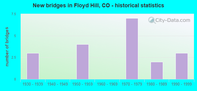
- New bridges - historical statistics
- 31930-1939
- 41950-1959
- 71970-1979
- 21980-1989
- 31990-1999

- Reconstructed bridges - Historical Statistics
- 11980-1989
- 01990-1999
- 12000-2009


- Bridge Condition - Deck
- 53.8%Good
- 15.4%Satisfactory
- 23.1%Fair
- 7.7%Poor

- Bridge Condition - Superstructure
- 23.1%Very good
- 30.8%Good
- 23.1%Satisfactory
- 23.1%Fair

- Bridge Condition - Substructure
- 38.5%Good
- 38.5%Satisfactory
- 15.4%Fair
- 7.7%Poor

- Bridge Condition - Channel
- 57.1%Very good
- 28.6%Good
- 14.3%Satisfactory

- Bridge Condition - Culverts
- 66.7%Good
- 33.3%Fair
Find on map >> Show street view
Structure Number: A-20-32, Location: 1.3 MI SO OF I 70 (Lat: 39.702697, Lng: -105.378708), Route carried "on" structure: County highway , Year Built: 1978, Status: Open, Structure Length: 0.79m (2.59ft), Average Daily Traffic: 4,517 (year 2021), Truck Traffic: 9%, Average Future Daily Traffic: 5,194 (year 2041), Features Intersected: SODA CREEK, Facility Carried by Structure: COUNTY ROAD 65
Minimum Vertical Clearance: 30+ m (98+ ft), Kilometerpoint: 1.910, Lanes on structure: 2, Owner: County Highway Agency, Approaching Roadway Width: 7.3m (24.0ft), Skew: 1 degrees, Material/Design: Concrete, Design/Construction: Culvert, Number Of Spans In Main Unit: 2, Length of Maximum Span: 3.8m (12.5ft), Out-to-Out Width: 24.9m (81.7ft)
Condition: Channel: Satisfactory, Culverts: Good, Operating Rating: 36.3 metric tons, Method Used To Determine Operating Rating: Field evaluation and documented engineering judgment, Inventory Rating: 32.7 metric tons, Method Used To Determine Inventory Rating: Field evaluation and documented engineering judgment, Structural Evaluation: Better than present minimum criteria, Waterway Adequacy: Equal to present desirable criteria, Approach Roadway Alignment: Equal to present desirable criteria, Designated Inspection Frequency: Every 48 months, Inspection Date: Febuary 2019
Find on map >> Show street view
Structure Number: E-15-H, Location: 1.9 MI NO OF JCT US 6 (Lat: 39.763158, Lng: -105.424872), Route carried "on" structure: State highway 119A, Year Built: 1939, Status: Open, Structure Length: 1.34m (4.40ft), Average Daily Traffic: 9,400 (year 2020), Truck Traffic: 3%, Average Future Daily Traffic: 12,690 (year 2040), Design Load: H 15, Features Intersected: COTTONWOOD CREEK, Facility Carried by Structure: SH 119 ML
Minimum Vertical Clearance: 30+ m (98+ ft), Kilometerpoint: 3.286, Lanes on structure: 2, Base Highway Network: Yes, Owner: State Highway Agency, Approaching Roadway Width: 7.6m (24.9ft), Material/Design: Concrete, Design/Construction: Culvert, Number Of Spans In Main Unit: 3, Length of Maximum Span: 4.0m (13.1ft), Out-to-Out Width: 14.7m (48.2ft)
Condition: Channel: Very good, Culverts: Fair, Operating Rating: 36.3 metric tons, Method Used To Determine Operating Rating: Field evaluation and documented engineering judgment, Inventory Rating: 32.7 metric tons, Method Used To Determine Inventory Rating: Field evaluation and documented engineering judgment, Structural Evaluation: Somewhat better than minimum adequacy, Waterway Adequacy: Equal to present desirable criteria, Approach Roadway Alignment: Equal to present desirable criteria, Designated Inspection Frequency: Every 24 months, Inspection Date: August 2021
Find on map >> Show street view
Structure Number: F-15-AA, Location: US 6 OVER CLEAR CREEK (Lat: 39.746208, Lng: -105.398286), Route carried "on" structure: US 6G, Year Built: 1998, Status: Open, Structure Length: 2.32m (7.61ft), Average Daily Traffic: 5,600 (year 2020), Truck Traffic: 9%, Average Future Daily Traffic: 6,104 (year 2040), Design Load: HS 25 or greater, Features Intersected: CLEAR CREEK, Facility Carried by Structure: US 6 ML
Minimum Vertical Clearance: 30+ m (98+ ft), Kilometerpoint: 4.851, Lanes on structure: 3, Base Highway Network: Yes, Owner: State Highway Agency, Approaching Roadway Width: 13.4m (44.0ft), Skew: 3 degrees, Material/Design: Prestressed concrete, Design/Construction: Box Beam or Girders - Multiple, Number Of Spans In Main Unit: 1, Length of Maximum Span: 22.1m (72.5ft), Curb-To-Curb Width: 17.2m (56.4ft), Out-to-Out Width: 20.6m (67.6ft)
Condition: Deck: Good, Superstructure: Good, Substructure: Satisfactory, Channel: Very good, Operating Rating: 78.1 metric tons, Method Used To Determine Operating Rating: Load Factor (LF), Inventory Rating: 21.8 metric tons, Method Used To Determine Inventory Rating: Load Factor (LF), Structural Evaluation: Somewhat better than minimum adequacy, Deck Geometry: Superior to present desirable criteria, Waterway Adequacy: Equal to present desirable criteria, Approach Roadway Alignment: Equal to present minimum criteria, Designated Inspection Frequency: Every 24 months, Inspection Date: September 2021, Deck Structure Type: Concrete Cast-file-Place, Wearing Surface/Protective System: Wearing Surface: Monolithic Concrete
Find on map >> Show street view
Structure Number: F-15-AB, Location: US 6 OVER CLEAR CREEK (Lat: 39.746581, Lng: -105.397914), Route carried "on" structure: US 6G, Year Built: 1998, Status: Open, Structure Length: 0.76m (2.49ft), Average Daily Traffic: 5,600 (year 2020), Truck Traffic: 9%, Average Future Daily Traffic: 6,104 (year 2040), Design Load: HS 25 or greater, Features Intersected: NORTH CLEAR CREEK, Facility Carried by Structure: US 6 ML
Minimum Vertical Clearance: 30+ m (98+ ft), Kilometerpoint: 4.880, Lanes on structure: 4, Base Highway Network: Yes, Owner: State Highway Agency, Approaching Roadway Width: 13.4m (44.0ft), Material/Design: Prestressed concrete, Design/Construction: Slab, Number Of Spans In Main Unit: 1, Length of Maximum Span: 7.0m (23.0ft), Curb-To-Curb Width: 29.1m (95.5ft), Out-to-Out Width: 50.9m (167.0ft)
Condition: Deck: Good, Superstructure: Good, Substructure: Good, Channel: Very good, Operating Rating: 89.8 metric tons, Method Used To Determine Operating Rating: Load Factor (LF), Inventory Rating: 58.7 metric tons, Method Used To Determine Inventory Rating: Load Factor (LF), Structural Evaluation: Better than present minimum criteria, Deck Geometry: Superior to present desirable criteria, Waterway Adequacy: Equal to present desirable criteria, Approach Roadway Alignment: Equal to present desirable criteria, Designated Inspection Frequency: Every 24 months, Inspection Date: September 2021, Deck Structure Type: Concrete Precast Panels, Wearing Surface/Protective System: Wearing Surface: Monolithic Concrete, Deck Protection: Epoxy Coated Reinforcing
Find on map >> Show street view
Structure Number: F-15-BL, Location: 8.7 MI W OF JCT SH 74 (Lat: 39.745900, Lng: -105.438800), Route carried "on" structure: Interstate 70A, Year Built: 1959, Status: Open, Structure Length: 16.53m (54.23ft), Average Daily Traffic: 23,500 (year 2020), Truck Traffic: 7%, Average Future Daily Traffic: 29,140 (year 2040), Design Load: HS 20+Mod, Features Intersected: US 6, CLEAR CREEK, Facility Carried by Structure: I 70 ML WBND
Minimum Vertical Clearance: 30+ m (98+ ft), Kilometerpoint: 394.737, Lanes on structure: 2, Lanes under structure: 2, Base Highway Network: Yes, Owner: State Highway Agency, Approaching Roadway Width: 11.6m (38.1ft), Skew: 19 degrees, Material/Design: Steel, Design/Construction: Stringer/Multi-beam, Number Of Spans In Main Unit: 5, Number Of Approach Spans: 1, Length of Maximum Span: 29.3m (96.1ft), Curb-To-Curb Width: 9.1m (29.9ft), Out-to-Out Width: 10.4m (34.1ft)
Condition: Deck: Fair, Superstructure: Fair, Substructure: Satisfactory, Channel: Very good, Operating Rating: 25.0 metric tons, Method Used To Determine Operating Rating: Load Factor (LF), Inventory Rating: 15.0 metric tons, Method Used To Determine Inventory Rating: Load Factor (LF), Structural Evaluation: High priority of corrective action, Deck Geometry: Meets minimum limits, Underclear: Somewhat better than minimum adequacy, Waterway Adequacy: Equal to present desirable criteria, Approach Roadway Alignment: Equal to present minimum criteria, Length Of Structure Improvement: 16.52m (54.20ft), Designated Inspection Frequency: Every 24 months, Inspection Date: May 2021, Bridge Improvement Cost: $2,919,000, Roadway Improvement Cost: $292,000, Total Project Cost: $4,378,000, Deck Structure Type: Concrete Cast-file-Place, Wearing Surface/Protective System: Wearing Surface: Bituminous, Membrane: Built-up
Find on map >> Show street view
Structure Number: F-15-BM, Location: 5.7 MI E OF JCT SH 103 (Lat: 39.746456, Lng: -105.437092), Route carried "on" structure: Ramp Interstate 70A, Year Built: 1959, Status: Open, Structure Length: 4.92m (16.14ft), Average Daily Traffic: 41,000 (year 2020), Truck Traffic: 7%, Average Future Daily Traffic: 50,840 (year 2040), Design Load: HS 20+Mod, Features Intersected: CLEAR CREEK R, Facility Carried by Structure: RAMP TO US 6 ML
Minimum Vertical Clearance: 30+ m (98+ ft), Kilometerpoint: 0.394, Lanes on structure: 2, Base Highway Network: Yes, Owner: State Highway Agency, Approaching Roadway Width: 9.1m (29.9ft), Skew: 1 degrees, Material/Design: Steel, Design/Construction: Stringer/Multi-beam, Number Of Spans In Main Unit: 4, Length of Maximum Span: 12.6m (41.3ft), Curb or Sidewalk Widths: Left: 0.6m (2.0ft), Right: 0.0m, Curb-To-Curb Width: 9.1m (29.9ft), Out-to-Out Width: 10.4m (34.1ft)
Condition: Deck: Fair, Superstructure: Satisfactory, Substructure: Poor, Channel: Very good, Operating Rating: 45.9 metric tons, Method Used To Determine Operating Rating: Load Factor (LF), Inventory Rating: 27.5 metric tons, Method Used To Determine Inventory Rating: Load Factor (LF), Structural Evaluation: Meets minimum limits, Deck Geometry: Meets minimum limits, Waterway Adequacy: Equal to present desirable criteria, Approach Roadway Alignment: Somewhat better than minimum adequacy, Designated Inspection Frequency: Every 24 months, Inspection Date: December 2021, Deck Structure Type: Concrete Cast-file-Place, Wearing Surface/Protective System: Wearing Surface: Bituminous
Find on map >> Show street view
Structure Number: F-15-C, Location: 1.8 MI E OF JCT SH 119 (Lat: 39.736728, Lng: -105.370867), Route carried "on" structure: US 6G, Year Built: 1950, Year Reconstructed: 2009, Status: Open, Structure Length: 0.64m (2.10ft), Average Daily Traffic: 7,500 (year 2020), Truck Traffic: 8%, Average Future Daily Traffic: 8,175 (year 2040), Design Load: H 20, Features Intersected: MAYHEM GULCH, Facility Carried by Structure: US 6 ML
Minimum Vertical Clearance: 30+ m (98+ ft), Kilometerpoint: 8.048, Lanes on structure: 3, Base Highway Network: Yes, Owner: State Highway Agency, Approaching Roadway Width: 9.1m (29.9ft), Material/Design: Concrete, Design/Construction: Culvert, Number Of Spans In Main Unit: 2, Length of Maximum Span: 3.0m (9.8ft), Curb-To-Curb Width: 14.8m (48.6ft), Out-to-Out Width: 35.8m (117.5ft)
Condition: Channel: Good, Culverts: Good, Operating Rating: 36.3 metric tons, Method Used To Determine Operating Rating: Field evaluation and documented engineering judgment, Inventory Rating: 32.7 metric tons, Method Used To Determine Inventory Rating: Field evaluation and documented engineering judgment, Structural Evaluation: Better than present minimum criteria, Deck Geometry: Equal to present minimum criteria, Waterway Adequacy: Equal to present desirable criteria, Approach Roadway Alignment: Better than present minimum criteria, Designated Inspection Frequency: Every 24 months, Inspection Date: September 2021
Find on map >> Show street view
Structure Number: F-15-CA, Location: 3.8 MI E OF JCT US 6 (Lat: 39.721597, Lng: -105.409622), Route carried "on" structure: County highway , Year Built: 1973, Status: Open, Structure Length: 7.38m (24.21ft), Average Daily Traffic: 3,639 (year 2021), Truck Traffic: 8%, Average Future Daily Traffic: 4,548 (year 2041), Design Load: HS 20, Features Intersected: I 70 ML, Facility Carried by Structure: COUNTY ROAD 182.1
Minimum Vertical Clearance: 30+ m (98+ ft), Kilometerpoint: 0.097, Lanes on structure: 2, Lanes under structure: 6, Owner: State Highway Agency, Approaching Roadway Width: 12.2m (40.0ft), Material/Design: Concrete continuous, Design/Construction: Box Beam or Girders - Multiple, Number Of Spans In Main Unit: 2, Length of Maximum Span: 37.5m (123.0ft), Curb-To-Curb Width: 12.2m (40.0ft), Out-to-Out Width: 13.0m (42.7ft)
Condition: Deck: Good, Superstructure: Satisfactory, Substructure: Good, Operating Rating: 87.9 metric tons, Method Used To Determine Operating Rating: Load Factor (LF), Inventory Rating: 52.3 metric tons, Method Used To Determine Inventory Rating: Load Factor (LF), Structural Evaluation: Equal to present minimum criteria, Deck Geometry: Equal to present minimum criteria, Underclear: Superior to present desirable criteria, Approach Roadway Alignment: Equal to present minimum criteria, Designated Inspection Frequency: Every 24 months, Inspection Date: December 2021, Deck Structure Type: Concrete Cast-file-Place, Wearing Surface/Protective System: Wearing Surface: Bituminous, Membrane: Preformed Fabric
Find on map >> Show street view
Structure Number: F-15-CB, Location: 4.9 MI E OF JCT US 6 (Lat: 39.715092, Lng: -105.391536), Route carried "on" structure: County highway , Year Built: 1971, Status: Open, Structure Length: 6.86m (22.51ft), Average Daily Traffic: 4,767 (year 2021), Truck Traffic: 8%, Average Future Daily Traffic: 5,483 (year 2041), Design Load: HS 20+Mod, Features Intersected: I 70 ML, Facility Carried by Structure: COUNTY ROAD 65
Minimum Vertical Clearance: 30+ m (98+ ft), Kilometerpoint: 0.000, Lanes on structure: 2, Lanes under structure: 6, Owner: State Highway Agency, Approaching Roadway Width: 12.2m (40.0ft), Material/Design: Concrete continuous, Design/Construction: Box Beam or Girders - Single/Spread, Number Of Spans In Main Unit: 2, Length of Maximum Span: 35.7m (117.1ft), Curb-To-Curb Width: 12.2m (40.0ft), Out-to-Out Width: 13.0m (42.7ft)
Condition: Deck: Good, Superstructure: Good, Substructure: Good, Operating Rating: 48.4 metric tons, Method Used To Determine Operating Rating: Load Factor (LF), Inventory Rating: 28.8 metric tons, Method Used To Determine Inventory Rating: Load Factor (LF), Structural Evaluation: Better than present minimum criteria, Deck Geometry: Equal to present minimum criteria, Underclear: Better than present minimum criteria, Approach Roadway Alignment: Equal to present minimum criteria, Designated Inspection Frequency: Every 24 months, Inspection Date: December 2021, Deck Structure Type: Concrete Cast-file-Place, Wearing Surface/Protective System: Wearing Surface: Bituminous, Membrane: Preformed Fabric
Find on map >> Show street view
Structure Number: F-15-CM, Location: 4.7 MI E OF JCT SH 103 (Lat: 39.745342, Lng: -105.439633), Route carried "on" structure: Interstate 70A, Year Built: 1974, Status: Open, Structure Length: 7.41m (24.31ft), Average Daily Traffic: 23,500 (year 2020), Truck Traffic: 7%, Average Future Daily Traffic: 29,140 (year 2040), Design Load: HS 20+Mod, Features Intersected: CO RD, CLEAR CREEK, Facility Carried by Structure: I 70 ML EBND
Minimum Vertical Clearance: 30+ m (98+ ft), Kilometerpoint: 394.656, Lanes on structure: 3, Lanes under structure: 1, Base Highway Network: Yes, Owner: State Highway Agency, Approaching Roadway Width: 15.2m (49.9ft), Skew: 19 degrees, Material/Design: Steel, Design/Construction: Stringer/Multi-beam, Number Of Spans In Main Unit: 3, Number Of Approach Spans: 1, Length of Maximum Span: 24.5m (80.4ft), Curb-To-Curb Width: 16.5m (54.1ft), Out-to-Out Width: 17.2m (56.4ft)
Condition: Deck: Fair, Superstructure: Fair, Substructure: Fair, Channel: Good, Operating Rating: 57.6 metric tons, Method Used To Determine Operating Rating: Load Factor (LF), Inventory Rating: 34.5 metric tons, Method Used To Determine Inventory Rating: Load Factor (LF), Structural Evaluation: Somewhat better than minimum adequacy, Deck Geometry: Equal to present minimum criteria, Underclear: Meets minimum limits, Waterway Adequacy: Equal to present desirable criteria, Approach Roadway Alignment: Equal to present minimum criteria, Designated Inspection Frequency: Every 24 months, Inspection Date: May 2021, Deck Structure Type: Concrete Cast-file-Place, Wearing Surface/Protective System: Wearing Surface: Bituminous
Find on map >> Show street view
Structure Number: F-15-CN, Location: BASE OF FLOYD HILL (Lat: 39.742025, Lng: -105.431672), Route carried "on" structure: US 40B, Year Built: 1973, Status: Open, Structure Length: 5.09m (16.70ft), Average Daily Traffic: 2,100 (year 2020), Truck Traffic: 6%, Average Future Daily Traffic: 2,583 (year 2040), Design Load: HS 20+Mod, Features Intersected: CLEAR CREEK, Facility Carried by Structure: US 40 ML
Minimum Vertical Clearance: 30+ m (98+ ft), Kilometerpoint: 0.079, Lanes on structure: 2, Owner: State Highway Agency, Approaching Roadway Width: 7.9m (25.9ft), Skew: 2 degrees, Material/Design: Prestressed concrete, Design/Construction: Stringer/Multi-beam, Number Of Spans In Main Unit: 2, Length of Maximum Span: 24.4m (80.1ft), Curb-To-Curb Width: 9.8m (32.2ft), Out-to-Out Width: 10.5m (34.4ft)
Condition: Deck: Good, Superstructure: Very good, Substructure: Satisfactory, Channel: Very good, Operating Rating: 61.2 metric tons, Method Used To Determine Operating Rating: Load Factor (LF), Inventory Rating: 24.6 metric tons, Method Used To Determine Inventory Rating: Load Factor (LF), Structural Evaluation: Equal to present minimum criteria, Deck Geometry: Meets minimum limits, Waterway Adequacy: Equal to present desirable criteria, Approach Roadway Alignment: Equal to present desirable criteria, Designated Inspection Frequency: Every 24 months, Inspection Date: May 2021, Deck Structure Type: Concrete Cast-file-Place, Wearing Surface/Protective System: Wearing Surface: Bituminous, Membrane: Built-up
Find on map >> Show street view
Structure Number: F-15-CO, Location: 1.5 MI E OF JCT I70 (Lat: 39.736811, Lng: -105.420333), Route carried "on" structure: US 6G, Year Built: 1984, Status: Open, Structure Length: 2.77m (9.09ft), Average Daily Traffic: 5,600 (year 2020), Truck Traffic: 9%, Average Future Daily Traffic: 6,104 (year 2040), Design Load: HS 20, Features Intersected: CLEAR CREEK, Facility Carried by Structure: US 6 ML
Minimum Vertical Clearance: 30+ m (98+ ft), Kilometerpoint: 2.314, Lanes on structure: 2, Base Highway Network: Yes, Owner: State Highway Agency, Approaching Roadway Width: 8.5m (27.9ft), Skew: 5 degrees, Material/Design: Prestressed concrete, Design/Construction: Stringer/Multi-beam, Number Of Spans In Main Unit: 1, Length of Maximum Span: 26.8m (87.9ft), Curb-To-Curb Width: 12.2m (40.0ft), Out-to-Out Width: 13.0m (42.7ft)
Condition: Deck: Good, Superstructure: Very good, Substructure: Good, Channel: Good, Operating Rating: 71.8 metric tons, Method Used To Determine Operating Rating: Load Factor (LF), Inventory Rating: 30.8 metric tons, Method Used To Determine Inventory Rating: Load Factor (LF), Structural Evaluation: Better than present minimum criteria, Deck Geometry: Somewhat better than minimum adequacy, Waterway Adequacy: Equal to present desirable criteria, Approach Roadway Alignment: Better than present minimum criteria, Designated Inspection Frequency: Every 24 months, Inspection Date: September 2021, Deck Structure Type: Concrete Cast-file-Place, Wearing Surface/Protective System: Wearing Surface: Bituminous, Membrane: Preformed Fabric, Deck Protection: Epoxy Coated Reinforcing
Find on map >> Show street view
Structure Number: F-15-CP, Location: 2.8 MI E OF JCT I-70 (Lat: 39.746875, Lng: -105.401811), Route carried "on" structure: US 6G, Year Built: 1984, Status: Open, Structure Length: 2.35m (7.71ft), Average Daily Traffic: 5,600 (year 2020), Truck Traffic: 9%, Average Future Daily Traffic: 6,104 (year 2040), Design Load: HS 20, Features Intersected: CLEAR CREEK, Facility Carried by Structure: US 6 ML
Minimum Vertical Clearance: 30+ m (98+ ft), Kilometerpoint: 4.505, Lanes on structure: 2, Base Highway Network: Yes, Owner: State Highway Agency, Approaching Roadway Width: 10.4m (34.1ft), Skew: 4 degrees, Material/Design: Prestressed concrete, Design/Construction: Stringer/Multi-beam, Number Of Spans In Main Unit: 1, Length of Maximum Span: 20.7m (67.9ft), Curb-To-Curb Width: 12.2m (40.0ft), Out-to-Out Width: 13.0m (42.7ft)
Condition: Deck: Good, Superstructure: Very good, Substructure: Good, Channel: Very good, Operating Rating: 72.8 metric tons, Method Used To Determine Operating Rating: Load Factor (LF), Inventory Rating: 34.1 metric tons, Method Used To Determine Inventory Rating: Load Factor (LF), Structural Evaluation: Better than present minimum criteria, Deck Geometry: Somewhat better than minimum adequacy, Waterway Adequacy: Equal to present desirable criteria, Approach Roadway Alignment: Equal to present minimum criteria, Designated Inspection Frequency: Every 24 months, Inspection Date: September 2021, Deck Structure Type: Concrete Cast-file-Place, Wearing Surface/Protective System: Wearing Surface: Bituminous, Membrane: Preformed Fabric, Deck Protection: Epoxy Coated Reinforcing
Find on map >> Show street view
Structure Number: F-15-CY, Location: 2.4MI E OF JCT I70 (Lat: 39.743206, Lng: -105.406736), Route carried "on" structure: US 6G, Year Built: 1992, Status: Open, Structure Length: 2.96m (9.71ft), Average Daily Traffic: 5,600 (year 2020), Truck Traffic: 9%, Average Future Daily Traffic: 6,104 (year 2040), Design Load: HS 20+Mod, Features Intersected: CLEAR CREEK, Facility Carried by Structure: US 6 ML
Minimum Vertical Clearance: 30+ m (98+ ft), Kilometerpoint: 3.813, Lanes on structure: 2, Base Highway Network: Yes, Owner: State Highway Agency, Approaching Roadway Width: 12.2m (40.0ft), Skew: 2 degrees, Material/Design: Steel continuous, Design/Construction: Stringer/Multi-beam, Number Of Spans In Main Unit: 1, Length of Maximum Span: 27.6m (90.6ft), Curb-To-Curb Width: 11.6m (38.1ft), Out-to-Out Width: 12.9m (42.3ft)
Condition: Deck: Satisfactory, Superstructure: Good, Substructure: Satisfactory, Channel: Very good, Operating Rating: 72.6 metric tons, Method Used To Determine Operating Rating: Load Factor (LF), Inventory Rating: 43.6 metric tons, Method Used To Determine Inventory Rating: Load Factor (LF), Structural Evaluation: Equal to present minimum criteria, Deck Geometry: Somewhat better than minimum adequacy, Waterway Adequacy: Equal to present desirable criteria, Approach Roadway Alignment: Equal to present minimum criteria, Designated Inspection Frequency: Every 24 months, Inspection Date: September 2021, Deck Structure Type: Concrete Cast-file-Place, Wearing Surface/Protective System: Wearing Surface: Monolithic Concrete, Deck Protection: Epoxy Coated Reinforcing
Find on map >> Show street view
Structure Number: F-15-Q, Location: Behind Floyd Hill (Lat: 39.718319, Lng: -105.367894), Route carried "on" structure: US 40B, Year Built: 1937, Status: Open, Structure Length: 1.46m (4.79ft), Average Daily Traffic: 480 (year 2020), Truck Traffic: 3%, Average Future Daily Traffic: 706 (year 2040), Design Load: HS 20+Mod, Features Intersected: BEAVER BROOK, Facility Carried by Structure: US 40 ML
Minimum Vertical Clearance: 30+ m (98+ ft), Kilometerpoint: 7.229, Lanes on structure: 2, Owner: State Highway Agency, Approaching Roadway Width: 7.0m (23.0ft), Skew: 3 degrees, Material/Design: Steel, Design/Construction: Stringer/Multi-beam, Number Of Spans In Main Unit: 1, Length of Maximum Span: 13.5m (44.3ft), Curb-To-Curb Width: 9.1m (29.9ft), Out-to-Out Width: 10.4m (34.1ft)
Condition: Deck: Poor, Superstructure: Fair, Substructure: Fair, Channel: Satisfactory, Operating Rating: 34.6 metric tons, Method Used To Determine Operating Rating: Load Factor (LF), Inventory Rating: 20.7 metric tons, Method Used To Determine Inventory Rating: Load Factor (LF), Structural Evaluation: Somewhat better than minimum adequacy, Deck Geometry: Equal to present minimum criteria, Waterway Adequacy: Equal to present desirable criteria, Approach Roadway Alignment: Equal to present minimum criteria, Designated Inspection Frequency: Every 24 months, Inspection Date: August 2021, Deck Structure Type: Concrete Cast-file-Place, Wearing Surface/Protective System: Wearing Surface: Bituminous, Membrane: Built-up
Find on map >> Show street view
Structure Number: F-15-U, Location: 0.1 MI N OF JCT US 6 (Lat: 39.748656, Lng: -105.399369), Route carried "on" structure: ServiceState highway 119A, Year Built: 1939, Year Reconstructed: 1986, Status: Open, Structure Length: 3.35m (10.99ft), Average Daily Traffic: 9,400 (year 2020), Truck Traffic: 3%, Average Future Daily Traffic: 12,690 (year 2040), Design Load: H 15, Features Intersected: N FK CLEAR CREEK AR, Facility Carried by Structure: 119 SR/CDOT ACC RD
Minimum Vertical Clearance: 30+ m (98+ ft), Kilometerpoint: 0.269, Lanes on structure: 2, Owner: State Highway Agency, Approaching Roadway Width: 9.4m (30.8ft), Skew: 4 degrees, Material/Design: Steel continuous, Design/Construction: Stringer/Multi-beam, Number Of Spans In Main Unit: 2, Length of Maximum Span: 16.5m (54.1ft), Curb-To-Curb Width: 9.4m (30.8ft), Out-to-Out Width: 10.2m (33.5ft)
Condition: Deck: Satisfactory, Superstructure: Satisfactory, Substructure: Satisfactory, Channel: Good, Operating Rating: 59.2 metric tons, Method Used To Determine Operating Rating: Load Factor (LF), Inventory Rating: 35.5 metric tons, Method Used To Determine Inventory Rating: Load Factor (LF), Structural Evaluation: Equal to present minimum criteria, Deck Geometry: High priority of corrective action, Waterway Adequacy: Equal to present desirable criteria, Approach Roadway Alignment: Equal to present desirable criteria, Designated Inspection Frequency: Every 24 months, Inspection Date: August 2021, Deck Structure Type: Concrete Cast-file-Place, Wearing Surface/Protective System: Wearing Surface: Monolithic Concrete, Deck Protection: Epoxy Coated Reinforcing
Find on map >> Show street view
Structure Number: F-15-BL, Location: 8.7 MI W OF JCT SH 74 (Lat: 39.745900, Lng: -105.438800), Route carried "under" structure: US 6G, Year Built: 1959, Structure Length: 0. m, Average Daily Traffic: 3,700 (year 2011), Truck Traffic: 9%, Features Intersected: US 6, CLEAR CREEK, Facility Carried by Structure: I 70 ML WBND
Minimum Vertical Clearance: 5.44m (17.85ft), Kilometerpoint: 413.888, Lanes on structure: 2, Lanes under structure: 2, Material/Design: Steel, Design/Construction: Stringer/Multi-beam, Length of Maximum Span: 29.3m (96.1ft)
Find on map >> Show street view
Structure Number: F-15-CA, Location: 3.8 MI E OF JCT US 6 (Lat: 39.721597, Lng: -105.409622), Route carried "under" structure: Interstate 70A, Year Built: 1973, Structure Length: 0. m, Average Daily Traffic: 1,500 (year 2018), Truck Traffic: 8%, Features Intersected: I 70 ML, Facility Carried by Structure: COUNTY ROAD 182.1
Minimum Vertical Clearance: 6.05m (19.85ft), Kilometerpoint: 0.097, Lanes on structure: 2, Lanes under structure: 6, Material/Design: Concrete continuous, Design/Construction: Box Beam or Girders - Multiple, Length of Maximum Span: 37.5m (123.0ft)
Find on map >> Show street view
Structure Number: F-15-CB, Location: 4.9 MI E OF JCT US 6 (Lat: 39.715092, Lng: -105.391536), Route carried "under" structure: Interstate 70A, Year Built: 1971, Structure Length: 0. m, Average Daily Traffic: 5,605 (year 2016), Truck Traffic: 8%, Features Intersected: I 70 ML, Facility Carried by Structure: COUNTY ROAD 65
Minimum Vertical Clearance: 5.26m (17.26ft), Kilometerpoint: 0.045, Lanes on structure: 2, Lanes under structure: 6, Material/Design: Concrete continuous, Design/Construction: Box Beam or Girders - Single/Spread, Length of Maximum Span: 35.7m (117.1ft)