Bridge Statistics for Florence, Oregon (OR)
Condition, Traffic, Stress, Structural Evaluation, Project Costs
- National Bridge Inventory (NBI) Statistics
- 16Number of bridges
- 377ft / 115mTotal length
- $11,324,000Total costs
- 41,226Total average daily traffic
- 5,771Total average daily truck traffic
- National Bridge Inventory (NBI) Registered Bridges for Florence
- No street view available for this location
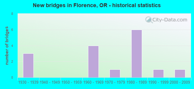
- New bridges - historical statistics
- 31930-1939
- 41960-1969
- 11970-1979
- 61980-1989
- 11990-1999
- 12000-2009
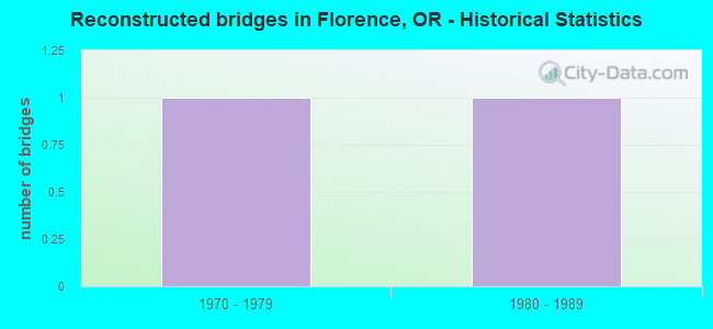
- Reconstructed bridges - Historical Statistics
- 11970-1979
- 11980-1989
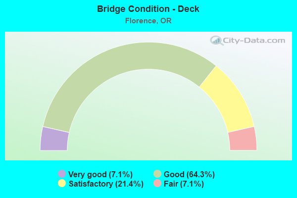
- Bridge Condition - Deck
- 7.1%Very good
- 64.3%Good
- 21.4%Satisfactory
- 7.1%Fair
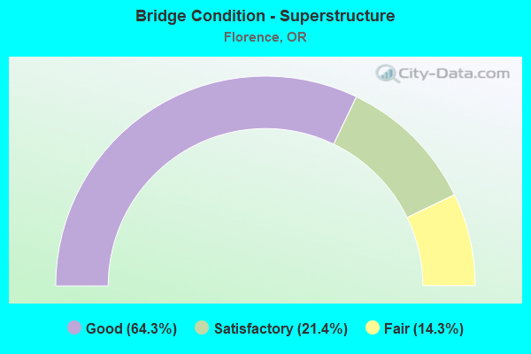
- Bridge Condition - Superstructure
- 64.3%Good
- 21.4%Satisfactory
- 14.3%Fair
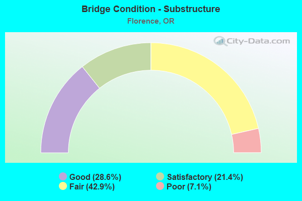
- Bridge Condition - Substructure
- 28.6%Good
- 21.4%Satisfactory
- 42.9%Fair
- 7.1%Poor
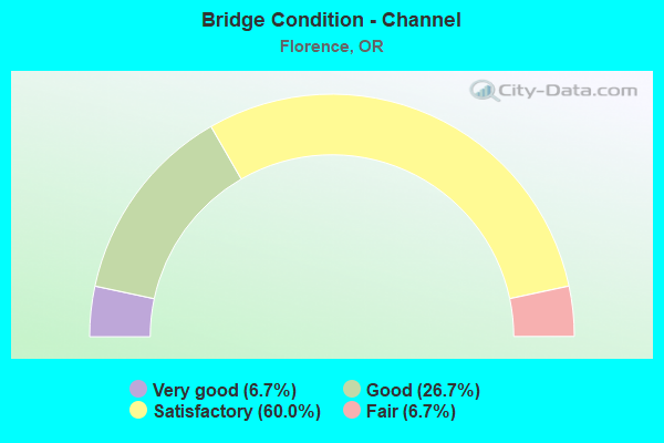
- Bridge Condition - Channel
- 6.7%Very good
- 26.7%Good
- 60.0%Satisfactory
- 6.7%Fair
Find on map >> Show street view
Structure Number: 1494A009 18478, Location: 05.5 MI N HWY 062 JCT (Lat: 44.053103, Lng: -124.097822), Route carried "on" structure: US 101, Year Built: 1930, Year Reconstructed: 1988, Status: Open, Structure Length: 3.35m (10.99ft), Average Daily Traffic: 4,172 (year 2020), Truck Traffic: 15%, Average Future Daily Traffic: 5,300 (year 2040), Design Load: H 15, Features Intersected: Sutton Creek
Minimum Vertical Clearance: 30+ m (98+ ft), Kilometerpoint: 297.375, Lanes on structure: 2, Base Highway Network: Yes, Owner: State Highway Agency, Approaching Roadway Width: 16.5m (54.1ft), Material/Design: Concrete continuous, Design/Construction: Tee Beam, Number Of Spans In Main Unit: 3, Length of Maximum Span: 12.8m (42.0ft), Curb-To-Curb Width: 16.5m (54.1ft), Out-to-Out Width: 17.3m (56.8ft)
Condition: Deck: Satisfactory, Superstructure: Satisfactory, Substructure: Satisfactory, Channel: Good, Operating Rating: 39.0 metric tons, Method Used To Determine Operating Rating: Load Factor (LF), Inventory Rating: 23.6 metric tons, Method Used To Determine Inventory Rating: Load Factor (LF), Structural Evaluation: Equal to present minimum criteria, Deck Geometry: Superior to present desirable criteria, Waterway Adequacy: Equal to present desirable criteria, Approach Roadway Alignment: Equal to present desirable criteria, Designated Inspection Frequency: Every 24 months, Inspection Date: July 2021, Deck Structure Type: Concrete Cast-file-Place, Wearing Surface/Protective System: Wearing Surface: Bituminous, Membrane: Preformed Fabric, Deck Protection: Epoxy Coated Reinforcing
Find on map >> Show street view
Structure Number: 1821E009 19098, Location: 00.7 MI S HWY 062 JCT (Lat: 43.964689, Lng: -124.108633), Route carried "on" structure: US 101, Year Built: 1936, Year Reconstructed: 1977, Status: Open, Structure Length: 50.27m (164.93ft), Average Daily Traffic: 9,007 (year 2020), Truck Traffic: 19%, Average Future Daily Traffic: 10,400 (year 2040), Design Load: H 15, Features Intersected: Siuslaw River
Minimum Vertical Clearance: 6.00m (19.69ft), Kilometerpoint: 307.353, Lanes on structure: 2, Lanes under structure: 2, Base Highway Network: Yes, Owner: State Highway Agency, Approaching Roadway Width: 8.2m (26.9ft), Navigation Control: Yes ( Vertical Clearance: 5.2m (17.1ft), Horizontal Clearance: 33.5m (109.9ft)), Material/Design: Steel, Design/Construction: Movable - Bascule, Number Of Spans In Main Unit: 1, Number Of Approach Spans: 22, Length of Maximum Span: 46.9m (153.9ft), Curb or Sidewalk Widths: Left: 1.1m (3.6ft), Right: 1.1m (3.6ft), Curb-To-Curb Width: 8.2m (26.9ft), Out-to-Out Width: 11.1m (36.4ft)
Condition: Deck: Fair, Superstructure: Fair, Substructure: Poor, Channel: Satisfactory, Operating Rating: 23.0 metric tons, Method Used To Determine Operating Rating: Load and Resistance Factor Rating (LRFR) rating reported by rating factor(RF) method using HL-93 loadings, Inventory Rating: 17.8 metric tons, Method Used To Determine Inventory Rating: Load and Resistance Factor Rating (LRFR) rating reported by rating factor(RF) method using HL-93 loadings, Structural Evaluation: Meets minimum limits, Deck Geometry: High priority of corrective action, Underclear: Meets minimum limits, Waterway Adequacy: Superior to present desirable criteria, Approach Roadway Alignment: Equal to present minimum criteria, Length Of Structure Improvement: 55.30m (181.43ft), Designated Inspection Frequency: Every 24 months, Critical Feature Inspection Frequency: Every 24 months, Underwater Inspection Frequency: Every 24 months, Inspection Date: July 2021, Critical Feature Inspection Date: July 2021, Underwater Inspection Date: October 2021, Bridge Improvement Cost: $5,810,000, Roadway Improvement Cost: $581,000, Total Project Cost: $9,295,000, Deck Structure Type: Concrete Cast-file-Place, Wearing Surface/Protective System: Wearing Surface: Epoxy Overlay
Find on map >> Show street view
Structure Number: 3996A062 00316, Location: 027 MI E FLORENCE (Lat: 43.985539, Lng: -124.044208), Route carried "on" structure: State highway 126, Year Built: 1966, Status: Open, Structure Length: 0.67m (2.20ft), Average Daily Traffic: 5,522 (year 2020), Truck Traffic: 18%, Average Future Daily Traffic: 6,000 (year 2040), Design Load: HS 20, Features Intersected: Patterson Creek
Minimum Vertical Clearance: 30+ m (98+ ft), Kilometerpoint: 5.150, Lanes on structure: 2, Base Highway Network: Yes, Owner: State Highway Agency, Approaching Roadway Width: 12.2m (40.0ft), Material/Design: Steel continuous, Design/Construction: Culvert, Number Of Spans In Main Unit: 3, Length of Maximum Span: 2.1m (6.9ft)
Condition: Channel: Good, Culverts: Satisfactory, Operating Rating: 89.7 metric tons, Method Used To Determine Operating Rating: Load and Resistance Factor Rating (LRFR) rating reported by rating factor(RF) method using HL-93 loadings, Inventory Rating: 69.0 metric tons, Method Used To Determine Inventory Rating: Load and Resistance Factor Rating (LRFR) rating reported by rating factor(RF) method using HL-93 loadings, Structural Evaluation: Equal to present minimum criteria, Waterway Adequacy: Equal to present desirable criteria, Approach Roadway Alignment: Equal to present desirable criteria, Designated Inspection Frequency: Every 24 months, Inspection Date: July 2020
Find on map >> Show street view
Structure Number: 61202000001118, Location: NO DATA ENTERED (Lat: 44.055000, Lng: -124.107800), Route carried "on" structure: Federal lands road 10607, Year Built: 1962, Status: Open, Structure Length: 1.23m (4.04ft), Average Daily Traffic: 10 (year 1996), Average Future Daily Traffic: 15 (year 2042), Design Load: HS 20, Features Intersected: SUTTON CREEK, Facility Carried by Structure: ROAD
Minimum Vertical Clearance: 30+ m (98+ ft), Kilometerpoint: 0.800, Lanes on structure: 2, Owner: U.S. Forest Service, Approaching Roadway Width: 9.1m (29.9ft), Material/Design: Prestressed concrete, Design/Construction: Tee Beam, Number Of Spans In Main Unit: 1, Length of Maximum Span: 12.3m (40.4ft), Curb or Sidewalk Widths: Left: 0.3m (1.0ft), Right: 1.1m (3.6ft), Curb-To-Curb Width: 7.9m (25.9ft), Out-to-Out Width: 9.3m (30.5ft)
Condition: Deck: Very good, Superstructure: Good, Substructure: Fair, Channel: Good, Operating Rating: 43.6 metric tons, Method Used To Determine Operating Rating: Load Factor (LF), Inventory Rating: 30.9 metric tons, Method Used To Determine Inventory Rating: Load Factor (LF), Structural Evaluation: Somewhat better than minimum adequacy, Deck Geometry: Equal to present minimum criteria, Waterway Adequacy: Somewhat better than minimum adequacy, Approach Roadway Alignment: Equal to present desirable criteria, Designated Inspection Frequency: Every 24 months, Inspection Date: September 2020, Deck Structure Type: Other
Find on map >> Show street view
Structure Number: 6688A062 00331, Location: 021 MI E OF FLORENCE (Lat: 43.986900, Lng: -124.041900), Route carried "on" structure: ServiceCounty highway 126, Year Built: 1986, Status: Open, Structure Length: 1.07m (3.51ft), Average Daily Traffic: 38 (year 2010), Truck Traffic: 1%, Average Future Daily Traffic: 43 (year 2030), Design Load: HS 25 or greater, Features Intersected: Patterson Creek, Facility Carried by Structure: Hwy 62 R/W Road
Minimum Vertical Clearance: 30+ m (98+ ft), Kilometerpoint: 5.327, Lanes on structure: 1, Base Highway Network: Yes, Owner: State Highway Agency, Approaching Roadway Width: 4.7m (15.4ft), Material/Design: Prestressed concrete, Design/Construction: Slab, Number Of Spans In Main Unit: 1, Length of Maximum Span: 10.7m (35.1ft), Curb-To-Curb Width: 4.7m (15.4ft), Out-to-Out Width: 4.9m (16.1ft)
Condition: Deck: Good, Superstructure: Good, Substructure: Fair, Channel: Good, Operating Rating: 38.6 metric tons, Method Used To Determine Operating Rating: Load and Resistance Factor Rating (LRFR) rating reported by rating factor(RF) method using HL-93 loadings, Inventory Rating: 29.8 metric tons, Method Used To Determine Inventory Rating: Load and Resistance Factor Rating (LRFR) rating reported by rating factor(RF) method using HL-93 loadings, Structural Evaluation: Somewhat better than minimum adequacy, Deck Geometry: Better than present minimum criteria, Waterway Adequacy: Equal to present desirable criteria, Approach Roadway Alignment: Equal to present desirable criteria, Designated Inspection Frequency: Every 24 months, Inspection Date: July 2020, Deck Structure Type: Concrete Precast Panels, Wearing Surface/Protective System: Wearing Surface: Bituminous, Membrane: Built-up
Find on map >> Show street view
Structure Number: 20153 062 00117, Location: 007 MI E FLORENCE (Lat: 43.976972, Lng: -124.080789), Route carried "on" structure: US 126, Year Built: 2009, Status: Open, Structure Length: 19.45m (63.81ft), Average Daily Traffic: 5,487 (year 2020), Truck Traffic: 18%, Average Future Daily Traffic: 6,000 (year 2040), Design Load: HL 93, Features Intersected: North Fork Siuslaw River
Minimum Vertical Clearance: 30+ m (98+ ft), Kilometerpoint: 1.883, Lanes on structure: 2, Base Highway Network: Yes, Owner: State Highway Agency, Approaching Roadway Width: 13.4m (44.0ft), Material/Design: Prestressed concrete continuous, Design/Construction: Stringer/Multi-beam, Number Of Spans In Main Unit: 5, Length of Maximum Span: 41.6m (136.5ft), Curb-To-Curb Width: 13.4m (44.0ft), Out-to-Out Width: 14.5m (47.6ft)
Condition: Deck: Good, Superstructure: Good, Substructure: Good, Channel: Very good, Operating Rating: 50.9 metric tons, Method Used To Determine Operating Rating: Load and Resistance Factor Rating (LRFR) rating reported by rating factor(RF) method using HL-93 loadings, Inventory Rating: 39.2 metric tons, Method Used To Determine Inventory Rating: Load and Resistance Factor Rating (LRFR) rating reported by rating factor(RF) method using HL-93 loadings, Structural Evaluation: Better than present minimum criteria, Deck Geometry: Equal to present minimum criteria, Waterway Adequacy: Equal to present desirable criteria, Approach Roadway Alignment: Equal to present desirable criteria, Designated Inspection Frequency: Every 24 months, Underwater Inspection Frequency: Every 60 months, Inspection Date: July 2020, Underwater Inspection Date: June 2019, Deck Structure Type: Concrete Cast-file-Place, Wearing Surface/Protective System: Wearing Surface: Monolithic Concrete, Deck Protection: Other Coated Reinforcing
Find on map >> Show street view
Structure Number: 39C526507000533, Location: 060 NE OF FLORENCE (Lat: 44.020481, Lng: -124.038681), Route carried "on" structure: County highway C5070, Year Built: 1969, Status: Open, Structure Length: 2.65m (8.69ft), Average Daily Traffic: 1,093 (year 2020), Truck Traffic: 10%, Average Future Daily Traffic: 1,263 (year 2025), Design Load: HS 20, Features Intersected: N. FORK SIUSLAW OVERFLOW, Facility Carried by Structure: N FORK SIUSLAW RD
Minimum Vertical Clearance: 30+ m (98+ ft), Kilometerpoint: 8.536, Lanes on structure: 2, Owner: County Highway Agency, Approaching Roadway Width: 7.9m (25.9ft), Skew: 9 degrees, Material/Design: Concrete continuous, Design/Construction: Slab, Number Of Spans In Main Unit: 3, Length of Maximum Span: 10.4m (34.1ft), Curb-To-Curb Width: 9.7m (31.8ft), Out-to-Out Width: 10.9m (35.8ft)
Condition: Deck: Good, Superstructure: Satisfactory, Substructure: Fair, Channel: Satisfactory, Operating Rating: 47.2 metric tons, Method Used To Determine Operating Rating: Load Factor (LF), Inventory Rating: 28.1 metric tons, Method Used To Determine Inventory Rating: Load Factor (LF), Structural Evaluation: Somewhat better than minimum adequacy, Deck Geometry: Somewhat better than minimum adequacy, Waterway Adequacy: Better than present minimum criteria, Approach Roadway Alignment: Equal to present minimum criteria, Designated Inspection Frequency: Every 24 months, Underwater Inspection Frequency: Every 36 months, Inspection Date: September 2021, Underwater Inspection Date: October 2021, Deck Structure Type: Concrete Cast-file-Place, Wearing Surface/Protective System: Wearing Surface: Monolithic Concrete
Find on map >> Show street view
Structure Number: 39C527507000548, Location: 060 NW OF FLORENCE (Lat: 44.021769, Lng: -124.035981), Route carried "on" structure: County highway C5070, Year Built: 1969, Status: Open, Structure Length: 5.24m (17.19ft), Average Daily Traffic: 1,093 (year 2020), Truck Traffic: 10%, Average Future Daily Traffic: 1,263 (year 2025), Design Load: HS 20, Features Intersected: N FORK SIUSLAW RIVER, Facility Carried by Structure: N FORK SIUSLAW RD
Minimum Vertical Clearance: 30+ m (98+ ft), Kilometerpoint: 8.792, Lanes on structure: 2, Owner: County Highway Agency, Approaching Roadway Width: 7.3m (24.0ft), Material/Design: Prestressed concrete, Design/Construction: Stringer/Multi-beam, Number Of Spans In Main Unit: 3, Length of Maximum Span: 24.4m (80.1ft), Curb-To-Curb Width: 9.7m (31.8ft), Out-to-Out Width: 10.8m (35.4ft)
Condition: Deck: Satisfactory, Superstructure: Good, Substructure: Fair, Channel: Fair, Operating Rating: 59.0 metric tons, Method Used To Determine Operating Rating: Allowable Stress (AS), Inventory Rating: 35.4 metric tons, Method Used To Determine Inventory Rating: Allowable Stress (AS), Structural Evaluation: Somewhat better than minimum adequacy, Deck Geometry: Somewhat better than minimum adequacy, Waterway Adequacy: Better than present minimum criteria, Approach Roadway Alignment: Equal to present minimum criteria, Designated Inspection Frequency: Every 24 months, Underwater Inspection Frequency: Every 36 months, Inspection Date: September 2021, Underwater Inspection Date: October 2021, Deck Structure Type: Concrete Cast-file-Place, Wearing Surface/Protective System: Wearing Surface: Bituminous
Find on map >> Show street view
Structure Number: 39C52850700056, Location: 061 NE OF FLORENCE (Lat: 44.021911, Lng: -124.033800), Route carried "on" structure: County highway C5070, Year Built: 1978, Status: Open, Structure Length: 4.91m (16.11ft), Average Daily Traffic: 1,037 (year 2020), Truck Traffic: 10%, Average Future Daily Traffic: 1,202 (year 2025), Design Load: HS 20, Features Intersected: N FORK SIUSLAW RIVER, Facility Carried by Structure: N FORK SIUSLAW RD
Minimum Vertical Clearance: 30+ m (98+ ft), Kilometerpoint: 8.966, Lanes on structure: 2, Owner: County Highway Agency, Approaching Roadway Width: 6.7m (22.0ft), Skew: 2 degrees, Material/Design: Prestressed concrete, Design/Construction: Box Beam or Girders - Multiple, Number Of Spans In Main Unit: 1, Number Of Approach Spans: 2, Length of Maximum Span: 27.4m (89.9ft), Curb-To-Curb Width: 9.2m (30.2ft), Out-to-Out Width: 9.8m (32.2ft)
Condition: Deck: Good, Superstructure: Fair, Substructure: Satisfactory, Channel: Satisfactory, Operating Rating: 40.8 metric tons, Method Used To Determine Operating Rating: Allowable Stress (AS), Inventory Rating: 24.5 metric tons, Method Used To Determine Inventory Rating: Allowable Stress (AS), Structural Evaluation: Somewhat better than minimum adequacy, Deck Geometry: Somewhat better than minimum adequacy, Waterway Adequacy: Equal to present desirable criteria, Approach Roadway Alignment: Better than present minimum criteria, Designated Inspection Frequency: Every 24 months, Inspection Date: September 2021, Deck Structure Type: Other, Wearing Surface/Protective System: Wearing Surface: Bituminous
Find on map >> Show street view
Structure Number: 39C529507000571, Location: 062 NW OF FLORENCE (Lat: 44.021600, Lng: -124.031811), Route carried "on" structure: County highway C5070, Year Built: 1994, Status: Open, Structure Length: 2.19m (7.19ft), Average Daily Traffic: 1,037 (year 2020), Truck Traffic: 10%, Average Future Daily Traffic: 1,182 (year 2025), Design Load: HS 25 or greater, Features Intersected: OVERFLOW, Facility Carried by Structure: N FORK SIUSLAW RD
Minimum Vertical Clearance: 30+ m (98+ ft), Kilometerpoint: 9.148, Lanes on structure: 2, Owner: County Highway Agency, Approaching Roadway Width: 8.5m (27.9ft), Material/Design: Prestressed concrete, Design/Construction: Slab, Number Of Spans In Main Unit: 3, Length of Maximum Span: 7.3m (24.0ft), Curb-To-Curb Width: 9.6m (31.5ft), Out-to-Out Width: 9.8m (32.2ft)
Condition: Deck: Good, Superstructure: Good, Substructure: Good, Channel: Satisfactory, Operating Rating: 56.2 metric tons, Method Used To Determine Operating Rating: Allowable Stress (AS), Inventory Rating: 33.6 metric tons, Method Used To Determine Inventory Rating: Allowable Stress (AS), Structural Evaluation: Better than present minimum criteria, Deck Geometry: Somewhat better than minimum adequacy, Waterway Adequacy: Better than present minimum criteria, Approach Roadway Alignment: Better than present minimum criteria, Designated Inspection Frequency: Every 24 months, Inspection Date: September 2021, Deck Structure Type: Other, Wearing Surface/Protective System: Wearing Surface: Bituminous
Find on map >> Show street view
Structure Number: 39C559522000025, Location: 0025 MI W HWY101-LILY LK (Lat: 44.088500, Lng: -124.114200), Route carried "on" structure: County highway C5220, Year Built: 1984, Status: Open, Structure Length: 1.16m (3.81ft), Average Daily Traffic: 32 (year 2020), Average Future Daily Traffic: 37 (year 2025), Design Load: HS 20, Features Intersected: QUARRY CREEK, Facility Carried by Structure: BAKER BEACH RD
Minimum Vertical Clearance: 30+ m (98+ ft), Kilometerpoint: 0.401, Lanes on structure: 2, Owner: County Highway Agency, Approaching Roadway Width: 6.7m (22.0ft), Material/Design: Prestressed concrete, Design/Construction: Slab, Number Of Spans In Main Unit: 1, Length of Maximum Span: 11.3m (37.1ft), Curb-To-Curb Width: 7.2m (23.6ft), Out-to-Out Width: 7.3m (24.0ft)
Condition: Deck: Satisfactory, Superstructure: Satisfactory, Substructure: Fair, Channel: Satisfactory, Operating Rating: 80.7 metric tons, Method Used To Determine Operating Rating: Load Factor (LF), Inventory Rating: 46.3 metric tons, Method Used To Determine Inventory Rating: Load Factor (LF), Structural Evaluation: Somewhat better than minimum adequacy, Deck Geometry: Somewhat better than minimum adequacy, Waterway Adequacy: Equal to present minimum criteria, Approach Roadway Alignment: Equal to present desirable criteria, Designated Inspection Frequency: Every 24 months, Inspection Date: September 2021, Deck Structure Type: Other, Wearing Surface/Protective System: Wearing Surface: Bituminous
Find on map >> Show street view
Structure Number: 39C561523000042, Location: 003 MI E HWY101-SUTTON LK (Lat: 44.054669, Lng: -124.090911), Route carried "on" structure: County highway C5230, Year Built: 1980, Status: Open, Structure Length: 4.79m (15.72ft), Average Daily Traffic: 1,512 (year 2020), Truck Traffic: 10%, Average Future Daily Traffic: 1,772 (year 2025), Design Load: HS 20, Features Intersected: MERCER CREEK, Facility Carried by Structure: SUTTON LAKE ROAD
Minimum Vertical Clearance: 30+ m (98+ ft), Kilometerpoint: 0.669, Lanes on structure: 2, Owner: County Highway Agency, Approaching Roadway Width: 7.3m (24.0ft), Material/Design: Prestressed concrete, Design/Construction: Slab, Number Of Spans In Main Unit: 5, Length of Maximum Span: 9.8m (32.2ft), Curb-To-Curb Width: 8.4m (27.6ft), Out-to-Out Width: 8.5m (27.9ft)
Condition: Deck: Good, Superstructure: Good, Substructure: Good, Channel: Satisfactory, Operating Rating: 49.9 metric tons, Method Used To Determine Operating Rating: Allowable Stress (AS), Inventory Rating: 29.9 metric tons, Method Used To Determine Inventory Rating: Allowable Stress (AS), Structural Evaluation: Better than present minimum criteria, Deck Geometry: Meets minimum limits, Waterway Adequacy: Equal to present desirable criteria, Approach Roadway Alignment: Equal to present minimum criteria, Designated Inspection Frequency: Every 24 months, Inspection Date: September 2021, Deck Structure Type: Other, Wearing Surface/Protective System: Wearing Surface: Bituminous
Find on map >> Show street view
Structure Number: 39C562523000134, Location: 010 MI E HWY101 AT SUTTON (Lat: 44.064739, Lng: -124.083900), Route carried "on" structure: County highway C5230, Year Built: 1981, Status: Open, Structure Length: 6.49m (21.29ft), Average Daily Traffic: 217 (year 2020), Truck Traffic: 5%, Average Future Daily Traffic: 252 (year 2025), Design Load: HS 20, Features Intersected: SUTTON LAKE, Facility Carried by Structure: SUTTON LAKE ROAD
Minimum Vertical Clearance: 30+ m (98+ ft), Kilometerpoint: 2.145, Lanes on structure: 2, Owner: County Highway Agency, Approaching Roadway Width: 7.6m (24.9ft), Material/Design: Prestressed concrete, Design/Construction: Slab, Number Of Spans In Main Unit: 6, Length of Maximum Span: 11.6m (38.1ft), Curb-To-Curb Width: 8.4m (27.6ft), Out-to-Out Width: 8.5m (27.9ft)
Condition: Deck: Good, Superstructure: Good, Substructure: Good, Channel: Satisfactory, Operating Rating: 88.9 metric tons, Method Used To Determine Operating Rating: Load Factor (LF), Inventory Rating: 28.1 metric tons, Method Used To Determine Inventory Rating: Load Factor (LF), Structural Evaluation: Better than present minimum criteria, Deck Geometry: Somewhat better than minimum adequacy, Waterway Adequacy: Equal to present desirable criteria, Approach Roadway Alignment: Better than present minimum criteria, Designated Inspection Frequency: Every 24 months, Inspection Date: September 2021, Deck Structure Type: Other, Wearing Surface/Protective System: Wearing Surface: Bituminous
Find on map >> Show street view
Structure Number: 39C563523000198, Location: 005 MI E HWY101-SUTTON LK (Lat: 44.069031, Lng: -124.090819), Route carried "on" structure: County highway C5230, Year Built: 1982, Status: Open, Structure Length: 0.85m (2.79ft), Average Daily Traffic: 117 (year 2020), Truck Traffic: 10%, Average Future Daily Traffic: 137 (year 2025), Design Load: HS 20, Features Intersected: RATH CREEK, Facility Carried by Structure: SUTTON LAKE ROAD
Minimum Vertical Clearance: 30+ m (98+ ft), Kilometerpoint: 3.114, Lanes on structure: 2, Owner: County Highway Agency, Approaching Roadway Width: 6.7m (22.0ft), Material/Design: Prestressed concrete, Design/Construction: Slab, Number Of Spans In Main Unit: 1, Length of Maximum Span: 8.2m (26.9ft), Curb-To-Curb Width: 8.4m (27.6ft), Out-to-Out Width: 8.5m (27.9ft)
Condition: Deck: Good, Superstructure: Good, Substructure: Satisfactory, Channel: Satisfactory, Operating Rating: 59.9 metric tons, Method Used To Determine Operating Rating: Load Factor (LF), Inventory Rating: 32.7 metric tons, Method Used To Determine Inventory Rating: Load Factor (LF), Structural Evaluation: Equal to present minimum criteria, Deck Geometry: Somewhat better than minimum adequacy, Waterway Adequacy: Equal to present minimum criteria, Approach Roadway Alignment: Better than present minimum criteria, Designated Inspection Frequency: Every 24 months, Inspection Date: September 2021, Deck Structure Type: Other, Wearing Surface/Protective System: Wearing Surface: Bituminous
Find on map >> Show street view
Structure Number: 39C564523300002, Location: 013 MI E HWY 101 (Lat: 44.066211, Lng: -124.069161), Route carried "on" structure: County highway C5233, Year Built: 1980, Status: Open, Structure Length: 10.97m (35.99ft), Average Daily Traffic: 152 (year 2020), Truck Traffic: 2%, Average Future Daily Traffic: 177 (year 2025), Design Load: HS 20, Features Intersected: MERCER LAKE/LAVERDIERECR, Facility Carried by Structure: DAHLIN ROAD
Minimum Vertical Clearance: 30+ m (98+ ft), Kilometerpoint: 0.080, Lanes on structure: 1, Owner: County Highway Agency, Approaching Roadway Width: 4.9m (16.1ft), Skew: 9 degrees, Material/Design: Prestressed concrete, Design/Construction: Slab, Number Of Spans In Main Unit: 13, Length of Maximum Span: 8.8m (28.9ft), Curb-To-Curb Width: 4.8m (15.7ft), Out-to-Out Width: 4.9m (16.1ft)
Condition: Deck: Good, Superstructure: Good, Substructure: Fair, Channel: Satisfactory, Operating Rating: 36.0 metric tons, Method Used To Determine Operating Rating: Load and Resistance Factor Rating (LRFR) rating reported by rating factor(RF) method using HL-93 loadings, Inventory Rating: 27.9 metric tons, Method Used To Determine Inventory Rating: Load and Resistance Factor Rating (LRFR) rating reported by rating factor(RF) method using HL-93 loadings, Structural Evaluation: Somewhat better than minimum adequacy, Deck Geometry: High priority of corrective action, Waterway Adequacy: Equal to present desirable criteria, Approach Roadway Alignment: Meets minimum limits, Length Of Structure Improvement: 12.10m (39.70ft), Designated Inspection Frequency: Every 24 months, Inspection Date: September 2021, Bridge Improvement Cost: $1,268,000, Roadway Improvement Cost: $127,000, Total Project Cost: $2,029,000, Deck Structure Type: Other, Wearing Surface/Protective System: Wearing Surface: Bituminous
Find on map >> Show street view
Structure Number: 1821E009 19098, Location: 00.7 MI S HWY 062 JCT (Lat: 43.964689, Lng: -124.108633), Route carried "under" structure: ServiceCity street , Year Built: 1936, Structure Length: 0. m, Average Daily Traffic: 10,700 (year 2010), Truck Traffic: 8%, Features Intersected: Siuslaw River, Facility Carried by Structure: US101 (HWY 9)
Minimum Vertical Clearance: 4.49m (14.73ft), Kilometerpoint: 0.000, Lanes on structure: 2, Lanes under structure: 2, Material/Design: Steel, Design/Construction: Movable - Bascule, Length of Maximum Span: 46.9m (153.9ft)