Bridge Statistics for Fish Hawk, Florida (FL)
Condition, Traffic, Stress, Structural Evaluation, Project Costs
- National Bridge Inventory (NBI) Statistics
- 11Number of bridges
- 197ft / 60.2mTotal length
- 96,540Total average daily traffic
- 4,970Total average daily truck traffic
- 116,760Total future (year 2040) average daily traffic
- National Bridge Inventory (NBI) Registered Bridges for Fish Hawk
- No street view available for this location
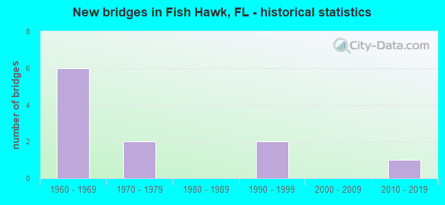
- New bridges - historical statistics
- 61960-1969
- 21970-1979
- 21990-1999
- 12010-2019
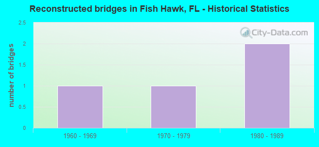
- Reconstructed bridges - Historical Statistics
- 11960-1969
- 11970-1979
- 21980-1989
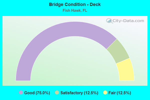
- Bridge Condition - Deck
- 75.0%Good
- 12.5%Satisfactory
- 12.5%Fair

- Bridge Condition - Superstructure
- 25.0%Very good
- 50.0%Good
- 25.0%Satisfactory
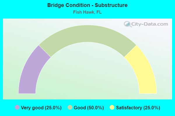
- Bridge Condition - Substructure
- 25.0%Very good
- 50.0%Good
- 25.0%Satisfactory
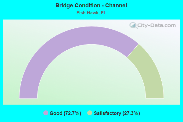
- Bridge Condition - Channel
- 72.7%Good
- 27.3%Satisfactory
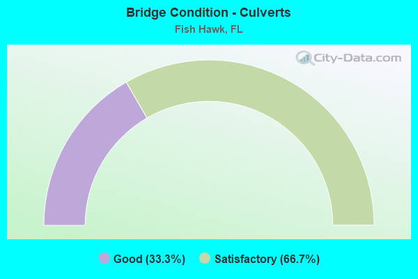
- Bridge Condition - Culverts
- 33.3%Good
- 66.7%Satisfactory
Find on map >> Show street view
Structure Number: 100247, Location: 6.2MI SOUTH OF SR-60 (Lat: 27.872617, Lng: -82.211319), Route carried "on" structure: County highway 640, Year Built: 1965, Status: Open, Structure Length: 9.75m (31.99ft), Average Daily Traffic: 8,800 (year 2020), Truck Traffic: 5%, Average Future Daily Traffic: 11,000 (year 2040), Design Load: HS 20, Features Intersected: ALAFIA RIVER
Minimum Vertical Clearance: 30+ m (98+ ft), Kilometerpoint: 10.152, Lanes on structure: 2, Owner: County Highway Agency, Approaching Roadway Width: 9.5m (31.2ft), Material/Design: Prestressed concrete, Design/Construction: Stringer/Multi-beam, Number Of Spans In Main Unit: 8, Length of Maximum Span: 12.2m (40.0ft), Curb-To-Curb Width: 9.1m (29.9ft), Out-to-Out Width: 10.7m (35.1ft)
Condition: Deck: Good, Superstructure: Good, Substructure: Good, Channel: Good, Operating Rating: 49.7 metric tons, Method Used To Determine Operating Rating: Allowable Stress (AS), Inventory Rating: 44.5 metric tons, Method Used To Determine Inventory Rating: Allowable Stress (AS), Structural Evaluation: Better than present minimum criteria, Deck Geometry: Meets minimum limits, Waterway Adequacy: Equal to present desirable criteria, Approach Roadway Alignment: Equal to present desirable criteria, Designated Inspection Frequency: Every 24 months, Inspection Date: April 2020, Deck Structure Type: Concrete Cast-file-Place
Find on map >> Show street view
Structure Number: 104327, Location: 1.2MI E OF HOBSON SIMMON (Lat: 27.822867, Lng: -82.203561), Route carried "on" structure: County highway , Year Built: 1976, Status: Open, Structure Length: 3.72m (12.20ft), Average Daily Traffic: 1,050 (year 2020), Truck Traffic: 5%, Average Future Daily Traffic: 1,313 (year 2040), Design Load: HS 20, Features Intersected: FISH HAWK CREEK, Facility Carried by Structure: BOYETTE ROAD
Minimum Vertical Clearance: 30.45m (99.90ft), Kilometerpoint: 3.048, Lanes on structure: 2, Owner: County Highway Agency, Approaching Roadway Width: 7.0m (23.0ft), Material/Design: Prestressed concrete, Design/Construction: Channel Beam, Number Of Spans In Main Unit: 4, Length of Maximum Span: 9.3m (30.5ft), Curb or Sidewalk Widths: Left: 0.6m (2.0ft), Right: 0.6m (2.0ft), Curb-To-Curb Width: 8.0m (26.2ft), Out-to-Out Width: 9.8m (32.2ft)
Condition: Deck: Fair, Superstructure: Satisfactory, Substructure: Satisfactory, Channel: Good, Operating Rating: 60.7 metric tons, Method Used To Determine Operating Rating: Load Factor (LF), Inventory Rating: 36.4 metric tons, Method Used To Determine Inventory Rating: Load Factor (LF), Structural Evaluation: Equal to present minimum criteria, Deck Geometry: Meets minimum limits, Waterway Adequacy: Better than present minimum criteria, Approach Roadway Alignment: Equal to present desirable criteria, Designated Inspection Frequency: Every 24 months, Underwater Inspection Frequency: Every 23 months, Inspection Date: April 2020, Underwater Inspection Date: April 2020, Deck Structure Type: Concrete Cast-file-Place
Find on map >> Show street view
Structure Number: 10433, Location: 2.5 MI S OF BLOOMINGDALE (Lat: 27.857261, Lng: -82.269236), Route carried "on" structure: County highway , Year Built: 1971, Status: Open, Structure Length: 14.17m (46.49ft), Average Daily Traffic: 17,500 (year 2020), Truck Traffic: 7%, Average Future Daily Traffic: 21,000 (year 2040), Design Load: HS 20, Features Intersected: ALAFIA RIVER, Facility Carried by Structure: BELL SHOALS ROAD
Minimum Vertical Clearance: 30+ m (98+ ft), Kilometerpoint: 0.381, Lanes on structure: 2, Owner: County Highway Agency, Approaching Roadway Width: 7.4m (24.3ft), Material/Design: Prestressed concrete, Design/Construction: Stringer/Multi-beam, Number Of Spans In Main Unit: 9, Length of Maximum Span: 15.7m (51.5ft), Curb-To-Curb Width: 12.3m (40.4ft), Out-to-Out Width: 12.9m (42.3ft)
Condition: Deck: Good, Superstructure: Good, Substructure: Good, Channel: Good, Operating Rating: 40.0 metric tons, Method Used To Determine Operating Rating: Allowable Stress (AS), Inventory Rating: 35.7 metric tons, Method Used To Determine Inventory Rating: Allowable Stress (AS), Structural Evaluation: Better than present minimum criteria, Deck Geometry: Somewhat better than minimum adequacy, Waterway Adequacy: Better than present minimum criteria, Approach Roadway Alignment: Equal to present desirable criteria, Designated Inspection Frequency: Every 24 months, Inspection Date: April 2020, Deck Structure Type: Concrete Cast-file-Place
Find on map >> Show street view
Structure Number: 104355, Location: 2.2MI SOUTH OF CR-640 (Lat: 27.816089, Lng: -82.145717), Route carried "on" structure: County highway 39, Year Built: 1962, Year Reconstructed: 1992, Status: Open, Structure Length: 0.64m (2.10ft), Average Daily Traffic: 5,110 (year 2021), Truck Traffic: 10%, Average Future Daily Traffic: 6,132 (year 2041), Design Load: H 15, Features Intersected: CHITO CREEK
Minimum Vertical Clearance: 30+ m (98+ ft), Kilometerpoint: 0.000, Lanes on structure: 2, Owner: County Highway Agency, Approaching Roadway Width: 9.8m (32.2ft), Material/Design: Concrete, Design/Construction: Culvert, Number Of Spans In Main Unit: 2, Length of Maximum Span: 3.3m (10.8ft)
Condition: Channel: Satisfactory, Culverts: Satisfactory, Operating Rating: 64.2 metric tons, Method Used To Determine Operating Rating: Load Factor (LF), Inventory Rating: 38.6 metric tons, Method Used To Determine Inventory Rating: Load Factor (LF), Structural Evaluation: Equal to present minimum criteria, Waterway Adequacy: Better than present minimum criteria, Approach Roadway Alignment: Equal to present desirable criteria, Designated Inspection Frequency: Every 24 months, Underwater Inspection Frequency: Every 23 months, Inspection Date: December 2021, Underwater Inspection Date: December 2021
Find on map >> Show street view
Structure Number: 104356, Location: 1.4MI SOUTH OF CR-640 (Lat: 27.829194, Lng: -82.145750), Route carried "on" structure: County highway 39, Year Built: 1962, Year Reconstructed: 1992, Status: Open, Structure Length: 0.93m (3.05ft), Average Daily Traffic: 5,110 (year 2021), Truck Traffic: 10%, Average Future Daily Traffic: 6,132 (year 2041), Design Load: H 15, Features Intersected: CHITO CREEK
Minimum Vertical Clearance: 30+ m (98+ ft), Kilometerpoint: 0.000, Lanes on structure: 2, Owner: County Highway Agency, Approaching Roadway Width: 9.8m (32.2ft), Skew: 9 degrees, Material/Design: Concrete, Design/Construction: Culvert, Number Of Spans In Main Unit: 2, Length of Maximum Span: 4.5m (14.8ft)
Condition: Channel: Satisfactory, Culverts: Good, Operating Rating: 46.7 metric tons, Method Used To Determine Operating Rating: Load Factor (LF), Inventory Rating: 28.0 metric tons, Method Used To Determine Inventory Rating: Load Factor (LF), Structural Evaluation: Better than present minimum criteria, Waterway Adequacy: Better than present minimum criteria, Approach Roadway Alignment: Equal to present desirable criteria, Designated Inspection Frequency: Every 24 months, Inspection Date: December 2021
Find on map >> Show street view
Structure Number: 104362, Location: 1.5MI E OF BELL SHOALS RD (Lat: 27.854131, Lng: -82.245933), Route carried "on" structure: County highway , Year Built: 1997, Status: Open, Structure Length: 12.57m (41.24ft), Average Daily Traffic: 22,350 (year 2020), Truck Traffic: 3%, Average Future Daily Traffic: 26,820 (year 2040), Design Load: HS 20+Mod, Features Intersected: FISHHAWK CREEK, Facility Carried by Structure: FISHHAWK BLVD.
Minimum Vertical Clearance: 30+ m (98+ ft), Kilometerpoint: 8.663, Lanes on structure: 2, Owner: County Highway Agency, Approaching Roadway Width: 10.3m (33.8ft), Material/Design: Prestressed concrete, Design/Construction: Stringer/Multi-beam, Number Of Spans In Main Unit: 5, Length of Maximum Span: 25.1m (82.3ft), Curb or Sidewalk Widths: Left: 0.0m, Right: 1.5m (4.9ft), Curb-To-Curb Width: 10.3m (33.8ft), Out-to-Out Width: 12.8m (42.0ft)
Condition: Deck: Good, Superstructure: Good, Substructure: Good, Channel: Good, Operating Rating: 72.9 metric tons, Method Used To Determine Operating Rating: Load Factor (LF), Inventory Rating: 43.6 metric tons, Method Used To Determine Inventory Rating: Load Factor (LF), Structural Evaluation: Better than present minimum criteria, Deck Geometry: Meets minimum limits, Waterway Adequacy: Equal to present desirable criteria, Approach Roadway Alignment: Equal to present desirable criteria, Designated Inspection Frequency: Every 24 months, Inspection Date: April 2020, Deck Structure Type: Concrete Cast-file-Place
Find on map >> Show street view
Structure Number: 104363, Location: 2.8MI E OF BELL SHOAL RD (Lat: 27.853086, Lng: -82.224344), Route carried "on" structure: County highway , Year Built: 1997, Status: Open, Structure Length: 6.10m (20.01ft), Average Daily Traffic: 22,350 (year 2020), Truck Traffic: 5%, Average Future Daily Traffic: 26,810 (year 2040), Design Load: HS 20+Mod, Features Intersected: LITTLE FISHHAWK CREEK, Facility Carried by Structure: FISHHAWK BLVD.
Minimum Vertical Clearance: 30+ m (98+ ft), Kilometerpoint: 10.935, Lanes on structure: 2, Owner: County Highway Agency, Approaching Roadway Width: 9.4m (30.8ft), Material/Design: Prestressed concrete, Design/Construction: Stringer/Multi-beam, Number Of Spans In Main Unit: 3, Length of Maximum Span: 20.3m (66.6ft), Curb or Sidewalk Widths: Left: 0.0m, Right: 1.5m (4.9ft), Curb-To-Curb Width: 10.1m (33.1ft), Out-to-Out Width: 12.8m (42.0ft)
Condition: Deck: Good, Superstructure: Very good, Substructure: Very good, Channel: Satisfactory, Operating Rating: 82.7 metric tons, Method Used To Determine Operating Rating: Load Factor (LF), Inventory Rating: 49.5 metric tons, Method Used To Determine Inventory Rating: Load Factor (LF), Structural Evaluation: Equal to present desirable criteria, Deck Geometry: Meets minimum limits, Waterway Adequacy: Superior to present desirable criteria, Approach Roadway Alignment: Equal to present minimum criteria, Designated Inspection Frequency: Every 24 months, Inspection Date: April 2020, Deck Structure Type: Concrete Cast-file-Place
Find on map >> Show street view
Structure Number: 10442, Location: 0.8MI S OF DURANT ROAD (Lat: 27.893406, Lng: -82.170522), Route carried "on" structure: County highway , Year Built: 1966, Status: Open, Structure Length: 0.92m (3.02ft), Average Daily Traffic: 4,000 (year 2021), Truck Traffic: 5%, Average Future Daily Traffic: 5,000 (year 2041), Features Intersected: TURKEY CREEK, Facility Carried by Structure: TURKEY CREEK RD
Minimum Vertical Clearance: 30+ m (98+ ft), Kilometerpoint: 0.766, Lanes on structure: 2, Owner: County Highway Agency, Approaching Roadway Width: 6.7m (22.0ft), Material/Design: Prestressed concrete, Design/Construction: Channel Beam, Number Of Spans In Main Unit: 1, Length of Maximum Span: 9.2m (30.2ft), Curb-To-Curb Width: 7.7m (25.3ft), Out-to-Out Width: 8.3m (27.2ft)
Condition: Deck: Good, Superstructure: Good, Substructure: Satisfactory, Channel: Good, Operating Rating: 62.7 metric tons, Method Used To Determine Operating Rating: Load Factor (LF), Inventory Rating: 37.6 metric tons, Method Used To Determine Inventory Rating: Load Factor (LF), Structural Evaluation: Equal to present minimum criteria, Deck Geometry: High priority of replacement, Waterway Adequacy: Better than present minimum criteria, Approach Roadway Alignment: Equal to present desirable criteria, Designated Inspection Frequency: Every 24 months, Inspection Date: December 2021, Deck Structure Type: Concrete Cast-file-Place, Wearing Surface/Protective System: Wearing Surface: Bituminous
Find on map >> Show street view
Structure Number: 104433, Location: 0.1MI WEST OF BOYETTE RD (Lat: 27.842758, Lng: -82.202356), Route carried "on" structure: County highway , Year Built: 1969, Year Reconstructed: 1972, Status: Open, Structure Length: 0.91m (2.99ft), Average Daily Traffic: 540 (year 2021), Truck Traffic: 2%, Average Future Daily Traffic: 810 (year 2041), Design Load: H 15, Features Intersected: LITTLE FISH HAWK, Facility Carried by Structure: DORMAN ROAD
Minimum Vertical Clearance: 30+ m (98+ ft), Kilometerpoint: 0.000, Lanes on structure: 2, Owner: County Highway Agency, Approaching Roadway Width: 6.2m (20.3ft), Material/Design: Prestressed concrete, Design/Construction: Channel Beam, Number Of Spans In Main Unit: 1, Length of Maximum Span: 9.1m (29.9ft), Curb or Sidewalk Widths: Left: 0.6m (2.0ft), Right: 0.6m (2.0ft), Curb-To-Curb Width: 7.9m (25.9ft), Out-to-Out Width: 9.8m (32.2ft)
Condition: Deck: Satisfactory, Superstructure: Satisfactory, Substructure: Good, Channel: Good, Operating Rating: 43.7 metric tons, Method Used To Determine Operating Rating: Load Factor (LF), Inventory Rating: 26.2 metric tons, Method Used To Determine Inventory Rating: Load Factor (LF), Structural Evaluation: Equal to present minimum criteria, Deck Geometry: Somewhat better than minimum adequacy, Waterway Adequacy: Equal to present desirable criteria, Approach Roadway Alignment: Equal to present desirable criteria, Designated Inspection Frequency: Every 24 months, Inspection Date: December 2021, Deck Structure Type: Concrete Cast-file-Place
Find on map >> Show street view
Structure Number: 104451, Location: 0.5 MI SOUTH OF CR-640 (Lat: 27.852631, Lng: -82.199489), Route carried "on" structure: County highway , Year Built: 1966, Year Reconstructed: 1970, Status: Open, Structure Length: 0.88m (2.89ft), Average Daily Traffic: 1,330 (year 2021), Truck Traffic: 5%, Average Future Daily Traffic: 1,663 (year 2041), Features Intersected: LITTLE FISH HAWK CREEK, Facility Carried by Structure: BOYETTE ROAD
Minimum Vertical Clearance: 30+ m (98+ ft), Kilometerpoint: 6.618, Lanes on structure: 2, Owner: County Highway Agency, Approaching Roadway Width: 6.1m (20.0ft), Material/Design: Concrete, Design/Construction: Culvert, Number Of Spans In Main Unit: 2, Length of Maximum Span: 4.4m (14.4ft), Curb or Sidewalk Widths: Left: 0.5m (1.6ft), Right: 0.5m (1.6ft), Curb-To-Curb Width: 8.2m (26.9ft), Out-to-Out Width: 9.0m (29.5ft)
Condition: Channel: Good, Culverts: Satisfactory, Operating Rating: 64.7 metric tons, Method Used To Determine Operating Rating: Load Factor (LF), Inventory Rating: 38.8 metric tons, Method Used To Determine Inventory Rating: Load Factor (LF), Structural Evaluation: Equal to present minimum criteria, Deck Geometry: Meets minimum limits, Waterway Adequacy: Better than present minimum criteria, Approach Roadway Alignment: Equal to present desirable criteria, Designated Inspection Frequency: Every 24 months, Inspection Date: December 2021, Deck Structure Type: Concrete Cast-file-Place, Wearing Surface/Protective System: Wearing Surface: Bituminous
Find on map >> Show street view
Structure Number: 1048, Location: 4.9MI SOUTH OF SR-60 (Lat: 27.866556, Lng: -82.143917), Route carried "on" structure: County highway 39, Year Built: 2010, Status: Open, Structure Length: 9.60m (31.50ft), Average Daily Traffic: 8,400 (year 2022), Truck Traffic: 2%, Average Future Daily Traffic: 10,080 (year 2042), Design Load: HL 93, Features Intersected: ALAFIA RIVER (SO. PRONG)
Minimum Vertical Clearance: 30+ m (98+ ft), Kilometerpoint: 0.000, Lanes on structure: 2, Owner: County Highway Agency, Approaching Roadway Width: 12.2m (40.0ft), Skew: 9 degrees, Material/Design: Prestressed concrete, Design/Construction: Stringer/Multi-beam, Number Of Spans In Main Unit: 5, Length of Maximum Span: 19.2m (63.0ft), Curb or Sidewalk Widths: Left: 1.6m (5.2ft), Right: 1.6m (5.2ft), Curb-To-Curb Width: 12.2m (40.0ft), Out-to-Out Width: 16.8m (55.1ft)
Condition: Deck: Good, Superstructure: Very good, Substructure: Very good, Channel: Good, Operating Rating: 49.3 metric tons, Method Used To Determine Operating Rating: Load and Resistance Factor (LRFR), Inventory Rating: 37.8 metric tons, Method Used To Determine Inventory Rating: Load and Resistance Factor (LRFR), Structural Evaluation: Equal to present desirable criteria, Deck Geometry: Somewhat better than minimum adequacy, Waterway Adequacy: Equal to present desirable criteria, Approach Roadway Alignment: Equal to present desirable criteria, Designated Inspection Frequency: Every 24 months, Inspection Date: January 2022, Deck Structure Type: Concrete Cast-file-Place