Bridge Statistics for Findlay, Illinois (IL)
Condition, Traffic, Stress, Structural Evaluation, Project Costs
- National Bridge Inventory (NBI) Statistics
- 13Number of bridges
- 423ft / 129mTotal length
- 10,405Total average daily traffic
- 1,069Total average daily truck traffic
- 12,854Total future (year 2032) average daily traffic
- National Bridge Inventory (NBI) Registered Bridges for Findlay
- No street view available for this location
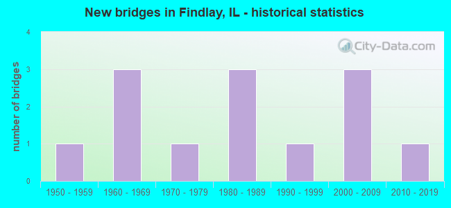
- New bridges - historical statistics
- 11950-1959
- 31960-1969
- 11970-1979
- 31980-1989
- 11990-1999
- 32000-2009
- 12010-2019


- Bridge Condition - Deck
- 12.5%Very good
- 25.0%Good
- 62.5%Satisfactory

- Bridge Condition - Superstructure
- 37.5%Very good
- 12.5%Good
- 37.5%Satisfactory
- 12.5%Fair

- Bridge Condition - Substructure
- 12.5%Very good
- 50.0%Good
- 37.5%Satisfactory

- Bridge Condition - Channel
- 50.0%Very good
- 16.7%Good
- 25.0%Satisfactory
- 8.3%Fair

- Bridge Condition - Culverts
- 80.0%Very good
- 20.0%Fair
Find on map >> Show street view
Structure Number: 704722, Location: 1 MI N OF FINDLEY (Lat: 39.535692, Lng: -88.715597), Route carried "on" structure: County highway , Year Built: 1969, Status: Open, Structure Length: 4.47m (14.67ft), Average Daily Traffic: 20 (year 2020), Truck Traffic: 5%, Average Future Daily Traffic: 25 (year 2032), Design Load: HS 20, Features Intersected: STREAM, Facility Carried by Structure: TR 167
Minimum Vertical Clearance: 30+ m (98+ ft), Kilometerpoint: 0.113, Lanes on structure: 2, Owner: Town or Township Highway Agency, Approaching Roadway Width: 4.9m (16.1ft), Material/Design: Prestressed concrete continuous, Design/Construction: Stringer/Multi-beam, Number Of Spans In Main Unit: 3, Length of Maximum Span: 14.2m (46.6ft), Curb-To-Curb Width: 7.9m (25.9ft), Out-to-Out Width: 8.5m (27.9ft)
Condition: Deck: Satisfactory, Superstructure: Satisfactory, Substructure: Good, Channel: Very good, Operating Rating: 63.8 metric tons, Method Used To Determine Operating Rating: Load Factor (LF) rating reported by rating factor (RF) method using MS18 loading, Inventory Rating: 38.2 metric tons, Method Used To Determine Inventory Rating: Load Factor (LF) rating reported by rating factor (RF) method using MS18 loading, Structural Evaluation: Equal to present minimum criteria, Deck Geometry: Equal to present minimum criteria, Waterway Adequacy: Superior to present desirable criteria, Approach Roadway Alignment: Superior to present desirable criteria, Designated Inspection Frequency: Every 24 months, Inspection Date: Febuary 2021, Deck Structure Type: Concrete Cast-file-Place, Wearing Surface/Protective System: Wearing Surface: Gravel
Find on map >> Show street view
Structure Number: 87003, Location: 1.75 MI S FINDLAY RD (Lat: 39.495897, Lng: -88.807858), Route carried "on" structure: State highway 128, Year Built: 2003, Status: Open, Structure Length: 5.16m (16.93ft), Average Daily Traffic: 2,500 (year 2021), Truck Traffic: 8%, Average Future Daily Traffic: 3,309 (year 2032), Design Load: HS 20+Mod, Features Intersected: UP RR
Minimum Vertical Clearance: 30+ m (98+ ft), Kilometerpoint: 64.533, Lanes on structure: 2, Base Highway Network: Yes, Owner: State Highway Agency, Approaching Roadway Width: 10.7m (35.1ft), Skew: 2 degrees, Material/Design: Prestressed concrete continuous, Design/Construction: Stringer/Multi-beam, Number Of Spans In Main Unit: 3, Length of Maximum Span: 22.7m (74.5ft), Curb-To-Curb Width: 10.8m (35.4ft), Out-to-Out Width: 11.8m (38.7ft)
Condition: Deck: Satisfactory, Superstructure: Very good, Substructure: Good, Operating Rating: 89.1 metric tons, Method Used To Determine Operating Rating: Load Factor (LF) rating reported by rating factor (RF) method using MS18 loading, Inventory Rating: 52.2 metric tons, Method Used To Determine Inventory Rating: Load Factor (LF) rating reported by rating factor (RF) method using MS18 loading, Structural Evaluation: Better than present minimum criteria, Deck Geometry: Somewhat better than minimum adequacy, Underclear: Equal to present desirable criteria, Approach Roadway Alignment: Equal to present desirable criteria, Designated Inspection Frequency: Every 48 months, Inspection Date: September 2019, Deck Structure Type: Concrete Cast-file-Place, Wearing Surface/Protective System: Deck Protection: Epoxy Coated Reinforcing
Find on map >> Show street view
Structure Number: 870031, Location: .3 MI S FINDLAY RD (Lat: 39.518797, Lng: -88.808069), Route carried "on" structure: State highway 128, Year Built: 2009, Status: Open, Structure Length: 2.33m (7.64ft), Average Daily Traffic: 2,500 (year 2021), Truck Traffic: 8%, Average Future Daily Traffic: 3,309 (year 2032), Design Load: HS 25 or greater, Features Intersected: ROBINSON CREEK TRIB
Minimum Vertical Clearance: 30+ m (98+ ft), Kilometerpoint: 67.060, Lanes on structure: 2, Base Highway Network: Yes, Owner: State Highway Agency, Approaching Roadway Width: 10.4m (34.1ft), Skew: 2 degrees, Material/Design: Steel, Design/Construction: Stringer/Multi-beam, Number Of Spans In Main Unit: 1, Length of Maximum Span: 22.0m (72.2ft), Curb-To-Curb Width: 11.0m (36.1ft), Out-to-Out Width: 11.9m (39.0ft)
Condition: Deck: Satisfactory, Superstructure: Very good, Substructure: Very good, Channel: Very good, Operating Rating: 89.1 metric tons, Method Used To Determine Operating Rating: Load Factor (LF) rating reported by rating factor (RF) method using MS18 loading, Inventory Rating: 54.4 metric tons, Method Used To Determine Inventory Rating: Load Factor (LF) rating reported by rating factor (RF) method using MS18 loading, Structural Evaluation: Equal to present desirable criteria, Deck Geometry: Somewhat better than minimum adequacy, Waterway Adequacy: Equal to present desirable criteria, Approach Roadway Alignment: Equal to present desirable criteria, Designated Inspection Frequency: Every 48 months, Inspection Date: November 2019, Deck Structure Type: Concrete Cast-file-Place, Wearing Surface/Protective System: Deck Protection: Epoxy Coated Reinforcing
Find on map >> Show street view
Structure Number: 873001, Location: 2 MI E OF FINDLEY (Lat: 39.521083, Lng: -88.708250), Route carried "on" structure: County highway , Year Built: 1967, Status: Open, Structure Length: 96.67m (317.16ft), Average Daily Traffic: 1,850 (year 2018), Truck Traffic: 13%, Average Future Daily Traffic: 1,916 (year 2032), Design Load: HS 20, Features Intersected: LAKE SHELBYVILLE, Facility Carried by Structure: CH 3(FAS 642)
Minimum Vertical Clearance: 30+ m (98+ ft), Kilometerpoint: 27.310, Lanes on structure: 2, Owner: County Highway Agency, Approaching Roadway Width: 8.5m (27.9ft), Material/Design: Prestressed concrete, Design/Construction: Stringer/Multi-beam, Number Of Spans In Main Unit: 42, Length of Maximum Span: 23.0m (75.5ft), Curb or Sidewalk Widths: Left: 0.6m (2.0ft), Right: 0.6m (2.0ft), Curb-To-Curb Width: 8.5m (27.9ft), Out-to-Out Width: 8.5m (27.9ft)
Condition: Deck: Satisfactory, Superstructure: Fair, Substructure: Satisfactory, Channel: Very good, Operating Rating: 54.1 metric tons, Method Used To Determine Operating Rating: Allowable Stress (AS) rating reported by rating factor (RF) method using MS18 loading, Inventory Rating: 33.4 metric tons, Method Used To Determine Inventory Rating: Allowable Stress (AS) rating reported by rating factor (RF) method using MS18 loading, Structural Evaluation: Somewhat better than minimum adequacy, Deck Geometry: Somewhat better than minimum adequacy, Waterway Adequacy: Equal to present desirable criteria, Approach Roadway Alignment: Equal to present desirable criteria, Designated Inspection Frequency: Every 24 months, Underwater Inspection Frequency: Every 60 months, Inspection Date: January 2020, Underwater Inspection Date: June 2018, Deck Structure Type: Concrete Cast-file-Place
Find on map >> Show street view
Structure Number: 873004, Location: 4 MI N OF FINDLAY (Lat: 39.579825, Lng: -88.754900), Route carried "on" structure: County highway , Year Built: 1967, Status: Open, Structure Length: 6.69m (21.95ft), Average Daily Traffic: 450 (year 2020), Truck Traffic: 7%, Average Future Daily Traffic: 522 (year 2032), Design Load: HS 15, Features Intersected: WILBURN CREEK, Facility Carried by Structure: CH 2(FAS 650)
Minimum Vertical Clearance: 30+ m (98+ ft), Kilometerpoint: 0.016, Lanes on structure: 2, Owner: County Highway Agency, Approaching Roadway Width: 7.3m (24.0ft), Material/Design: Prestressed concrete, Design/Construction: Stringer/Multi-beam, Number Of Spans In Main Unit: 3, Length of Maximum Span: 22.0m (72.2ft), Curb-To-Curb Width: 7.5m (24.6ft), Out-to-Out Width: 8.5m (27.9ft)
Condition: Deck: Good, Superstructure: Satisfactory, Substructure: Good, Channel: Satisfactory, Operating Rating: 36.0 metric tons, Method Used To Determine Operating Rating: Load Factor (LF) rating reported by rating factor (RF) method using MS18 loading, Inventory Rating: 21.7 metric tons, Method Used To Determine Inventory Rating: Load Factor (LF) rating reported by rating factor (RF) method using MS18 loading, Structural Evaluation: Equal to present minimum criteria, Deck Geometry: Meets minimum limits, Waterway Adequacy: Better than present minimum criteria, Approach Roadway Alignment: Equal to present desirable criteria, Designated Inspection Frequency: Every 24 months, Inspection Date: Febuary 2020, Deck Structure Type: Concrete Cast-file-Place, Wearing Surface/Protective System: Wearing Surface: Gravel
Find on map >> Show street view
Structure Number: 873061, Location: 3 MI N FINDLAY (Lat: 39.576372, Lng: -88.755236), Route carried "on" structure: County highway , Year Built: 1970, Status: Open, Structure Length: 3.72m (12.20ft), Average Daily Traffic: 75 (year 2018), Truck Traffic: 12%, Average Future Daily Traffic: 116 (year 2032), Design Load: HS 15, Features Intersected: STREAM, Facility Carried by Structure: TR 29
Minimum Vertical Clearance: 30+ m (98+ ft), Kilometerpoint: 4.619, Lanes on structure: 2, Owner: Town or Township Highway Agency, Approaching Roadway Width: 4.9m (16.1ft), Material/Design: Concrete, Design/Construction: Channel Beam, Number Of Spans In Main Unit: 3, Length of Maximum Span: 12.2m (40.0ft), Curb-To-Curb Width: 6.3m (20.7ft), Out-to-Out Width: 6.9m (22.6ft)
Condition: Deck: Satisfactory, Superstructure: Satisfactory, Substructure: Satisfactory, Channel: Satisfactory, Operating Rating: 46.0 metric tons, Method Used To Determine Operating Rating: Load Factor (LF) rating reported by rating factor (RF) method using MS18 loading, Inventory Rating: 27.5 metric tons, Method Used To Determine Inventory Rating: Load Factor (LF) rating reported by rating factor (RF) method using MS18 loading, Structural Evaluation: Equal to present minimum criteria, Deck Geometry: Somewhat better than minimum adequacy, Waterway Adequacy: Better than present minimum criteria, Approach Roadway Alignment: Equal to present desirable criteria, Designated Inspection Frequency: Every 24 months, Inspection Date: Febuary 2020, Deck Structure Type: Concrete Precast Panels, Wearing Surface/Protective System: Wearing Surface: Gravel
Find on map >> Show street view
Structure Number: 873391, Location: 3 MI N OF FINDLAY (Lat: 39.569331, Lng: -88.764344), Route carried "on" structure: County highway , Year Built: 1982, Status: Open, Structure Length: 2.38m (7.81ft), Average Daily Traffic: 25 (year 2018), Truck Traffic: 8%, Average Future Daily Traffic: 29 (year 2032), Design Load: HS 20, Features Intersected: STREAM, Facility Carried by Structure: TR 238
Minimum Vertical Clearance: 30+ m (98+ ft), Kilometerpoint: 1.239, Lanes on structure: 2, Owner: Town or Township Highway Agency, Approaching Roadway Width: 4.9m (16.1ft), Material/Design: Steel, Design/Construction: Stringer/Multi-beam, Number Of Spans In Main Unit: 3, Length of Maximum Span: 7.6m (24.9ft), Curb-To-Curb Width: 7.3m (24.0ft), Out-to-Out Width: 8.0m (26.2ft)
Condition: Deck: Good, Superstructure: Good, Substructure: Satisfactory, Channel: Fair, Operating Rating: 44.4 metric tons, Method Used To Determine Operating Rating: Assigned rating based on Load Factor Design (LFD) reported by rating factor (RF) using MS18 loading, Inventory Rating: 32.4 metric tons, Method Used To Determine Inventory Rating: Assigned rating based on Load Factor Design (LFD) reported by rating factor (RF) using MS18 loading, Structural Evaluation: Equal to present minimum criteria, Deck Geometry: Equal to present minimum criteria, Waterway Adequacy: Better than present minimum criteria, Approach Roadway Alignment: Equal to present desirable criteria, Designated Inspection Frequency: Every 24 months, Inspection Date: Febuary 2020, Deck Structure Type: Concrete Precast Panels, Wearing Surface/Protective System: Wearing Surface: Gravel
Find on map >> Show street view
Structure Number: 873403, Location: 1.95 MI NW FINDLAY (Lat: 39.536539, Lng: -88.784444), Route carried "on" structure: County highway , Year Built: 1987, Status: Open, Structure Length: 0.70m (2.30ft), Average Daily Traffic: 50 (year 2018), Truck Traffic: 2%, Average Future Daily Traffic: 87 (year 2032), Design Load: HS 20, Features Intersected: ROBINSON CREEK, Facility Carried by Structure: TR 51
Minimum Vertical Clearance: 30+ m (98+ ft), Kilometerpoint: 2.044, Lanes on structure: 2, Owner: Town or Township Highway Agency, Approaching Roadway Width: 7.3m (24.0ft), Material/Design: Concrete, Design/Construction: Culvert, Number Of Spans In Main Unit: 2, Length of Maximum Span: 3.4m (11.2ft), Curb-To-Curb Width: 7.3m (24.0ft), Out-to-Out Width: 7.3m (24.0ft)
Condition: Channel: Very good, Culverts: Very good, Operating Rating: 44.4 metric tons, Method Used To Determine Operating Rating: Assigned rating based on Load Factor Design (LFD) reported by rating factor (RF) using MS18 loading, Inventory Rating: 32.4 metric tons, Method Used To Determine Inventory Rating: Assigned rating based on Load Factor Design (LFD) reported by rating factor (RF) using MS18 loading, Structural Evaluation: Equal to present desirable criteria, Deck Geometry: Equal to present minimum criteria, Waterway Adequacy: Better than present minimum criteria, Approach Roadway Alignment: Equal to present minimum criteria, Designated Inspection Frequency: Every 48 months, Inspection Date: Febuary 2018, Wearing Surface/Protective System: Wearing Surface: Gravel
Find on map >> Show street view
Structure Number: 873448, Location: 1.75 MI W OF FINDLAY (Lat: 39.521919, Lng: -88.797736), Route carried "on" structure: County highway , Year Built: 1989, Status: Open, Structure Length: 1.06m (3.48ft), Average Daily Traffic: 1,900 (year 2018), Truck Traffic: 12%, Average Future Daily Traffic: 2,206 (year 2032), Design Load: HS 20+Mod, Features Intersected: ROBINSON CREEK TRIB, Facility Carried by Structure: FAS 642(CH 3)
Minimum Vertical Clearance: 30+ m (98+ ft), Kilometerpoint: 19.553, Lanes on structure: 2, Owner: County Highway Agency, Approaching Roadway Width: 9.1m (29.9ft), Skew: 5 degrees, Material/Design: Concrete, Design/Construction: Culvert, Number Of Spans In Main Unit: 2, Length of Maximum Span: 4.8m (15.7ft)
Condition: Channel: Very good, Culverts: Very good, Operating Rating: 44.4 metric tons, Method Used To Determine Operating Rating: Assigned rating based on Load Factor Design (LFD) reported by rating factor (RF) using MS18 loading, Inventory Rating: 32.4 metric tons, Method Used To Determine Inventory Rating: Assigned rating based on Load Factor Design (LFD) reported by rating factor (RF) using MS18 loading, Structural Evaluation: Equal to present desirable criteria, Waterway Adequacy: Equal to present desirable criteria, Approach Roadway Alignment: Equal to present desirable criteria, Designated Inspection Frequency: Every 48 months, Inspection Date: Febuary 2018
Find on map >> Show street view
Structure Number: 873457, Location: 3.5 MI NW FINDLEY (Lat: 39.572289, Lng: -88.792428), Route carried "on" structure: County highway , Year Built: 1996, Status: Open, Structure Length: 3.33m (10.93ft), Average Daily Traffic: 25 (year 2018), Truck Traffic: 8%, Average Future Daily Traffic: 58 (year 2032), Design Load: HS 20, Features Intersected: WILBORN CREEK TRIB, Facility Carried by Structure: TR 220
Minimum Vertical Clearance: 30+ m (98+ ft), Kilometerpoint: 0.885, Lanes on structure: 2, Owner: Town or Township Highway Agency, Approaching Roadway Width: 6.1m (20.0ft), Skew: 4 degrees, Material/Design: Prestressed concrete, Design/Construction: Box Beam or Girders - Multiple, Number Of Spans In Main Unit: 3, Length of Maximum Span: 11.7m (38.4ft), Curb-To-Curb Width: 7.3m (24.0ft), Out-to-Out Width: 7.3m (24.0ft)
Condition: Deck: Very good, Superstructure: Very good, Substructure: Good, Channel: Good, Operating Rating: 44.1 metric tons, Method Used To Determine Operating Rating: Assigned rating based on Load Factor Design (LFD) reported by rating factor (RF) using MS18 loading, Inventory Rating: 32.4 metric tons, Method Used To Determine Inventory Rating: Assigned rating based on Load Factor Design (LFD) reported by rating factor (RF) using MS18 loading, Structural Evaluation: Better than present minimum criteria, Deck Geometry: Equal to present minimum criteria, Waterway Adequacy: Equal to present desirable criteria, Approach Roadway Alignment: Equal to present desirable criteria, Designated Inspection Frequency: Every 48 months, Inspection Date: Febuary 2018, Deck Structure Type: Concrete Precast Panels, Wearing Surface/Protective System: Wearing Surface: Gravel
Find on map >> Show street view
Structure Number: 875005, Location: 3.4 MI W FINDLAY (Lat: 39.521925, Lng: -88.816025), Route carried "on" structure: County highway , Year Built: 1955, Status: Open, Structure Length: 1.01m (3.31ft), Average Daily Traffic: 950 (year 2018), Truck Traffic: 15%, Average Future Daily Traffic: 1,103 (year 2032), Design Load: H 15, Features Intersected: ROBINSON CREEK, Facility Carried by Structure: FAS 642(CH 19)
Minimum Vertical Clearance: 30+ m (98+ ft), Kilometerpoint: 17.992, Lanes on structure: 2, Owner: County Highway Agency, Approaching Roadway Width: 9.1m (29.9ft), Material/Design: Concrete, Design/Construction: Culvert, Number Of Spans In Main Unit: 3, Length of Maximum Span: 3.0m (9.8ft), Curb-To-Curb Width: 9.1m (29.9ft), Out-to-Out Width: 10.7m (35.1ft)
Condition: Channel: Satisfactory, Culverts: Fair, Operating Rating: 34.7 metric tons, Method Used To Determine Operating Rating: Load Factor (LF) rating reported by rating factor (RF) method using MS18 loading, Inventory Rating: 20.7 metric tons, Method Used To Determine Inventory Rating: Load Factor (LF) rating reported by rating factor (RF) method using MS18 loading, Structural Evaluation: Somewhat better than minimum adequacy, Deck Geometry: Equal to present minimum criteria, Waterway Adequacy: Better than present minimum criteria, Approach Roadway Alignment: Equal to present desirable criteria, Designated Inspection Frequency: Every 24 months, Inspection Date: March 2021, Deck Structure Type: Concrete Cast-file-Place, Wearing Surface/Protective System: Wearing Surface: Bituminous
Find on map >> Show street view
Structure Number: 87505, Location: .5 MI E OF FINDLEY (Lat: 39.523903, Lng: -88.730928), Route carried "on" structure: County highway , Year Built: 2001, Status: Open, Structure Length: 0.76m (2.49ft), Average Daily Traffic: 50 (year 2018), Truck Traffic: 24%, Average Future Daily Traffic: 145 (year 2032), Design Load: HS 20, Features Intersected: TRIB TO OKAW RIVER, Facility Carried by Structure: TR 276 A
Minimum Vertical Clearance: 30+ m (98+ ft), Kilometerpoint: 1.336, Lanes on structure: 2, Owner: Town or Township Highway Agency, Approaching Roadway Width: 5.5m (18.0ft), Material/Design: Concrete, Design/Construction: Culvert, Number Of Spans In Main Unit: 2, Length of Maximum Span: 3.4m (11.2ft)
Condition: Channel: Very good, Culverts: Very good, Operating Rating: 44.1 metric tons, Method Used To Determine Operating Rating: Assigned rating based on Load Factor Design (LFD) reported by rating factor (RF) using MS18 loading, Inventory Rating: 32.4 metric tons, Method Used To Determine Inventory Rating: Assigned rating based on Load Factor Design (LFD) reported by rating factor (RF) using MS18 loading, Structural Evaluation: Equal to present desirable criteria, Waterway Adequacy: Equal to present desirable criteria, Approach Roadway Alignment: Equal to present desirable criteria, Designated Inspection Frequency: Every 48 months, Inspection Date: Febuary 2018
Find on map >> Show street view
Structure Number: 875052, Location: 2.1 Mi. NW Findlay (Lat: 39.527892, Lng: -88.791981), Route carried "on" structure: County highway , Year Built: 2012, Status: Open, Structure Length: 0.69m (2.26ft), Average Daily Traffic: 10 (year 2018), Truck Traffic: 10%, Average Future Daily Traffic: 29 (year 2032), Features Intersected: Stream, Facility Carried by Structure: TR 220
Minimum Vertical Clearance: 30+ m (98+ ft), Kilometerpoint: 5.826, Lanes on structure: 2, Owner: Town or Township Highway Agency, Approaching Roadway Width: 4.9m (16.1ft), Skew: 4 degrees, Material/Design: Steel, Design/Construction: Culvert, Number Of Spans In Main Unit: 2, Length of Maximum Span: 3.4m (11.2ft), Curb-To-Curb Width: 4.9m (16.1ft)
Condition: Channel: Good, Culverts: Very good, Operating Rating: 67.1 metric tons, Method Used To Determine Operating Rating: Load Factor (LF) rating reported by rating factor (RF) method using MS18 loading, Inventory Rating: 40.2 metric tons, Method Used To Determine Inventory Rating: Load Factor (LF) rating reported by rating factor (RF) method using MS18 loading, Structural Evaluation: Equal to present desirable criteria, Deck Geometry: High priority of corrective action, Waterway Adequacy: Equal to present minimum criteria, Approach Roadway Alignment: Meets minimum limits, Designated Inspection Frequency: Every 24 months, Inspection Date: Febuary 2020, Deck Structure Type: Other