Bridge Statistics for Ferrysburg, Michigan (MI)
Condition, Traffic, Stress, Structural Evaluation, Project Costs
- National Bridge Inventory (NBI) Statistics
- 14Number of bridges
- 236ft / 72.0mTotal length
- $104,530,000Total costs
- 259,417Total average daily traffic
- 14,114Total average daily truck traffic
- National Bridge Inventory (NBI) Registered Bridges for Ferrysburg
- No street view available for this location
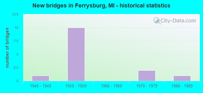
- New bridges - historical statistics
- 11940-1949
- 101950-1959
- 21970-1979
- 11980-1989


- Bridge Condition - Deck
- 33.3%Good
- 33.3%Satisfactory
- 22.2%Fair
- 11.1%Poor

- Bridge Condition - Superstructure
- 11.1%Very good
- 11.1%Good
- 11.1%Satisfactory
- 55.6%Fair
- 11.1%Serious

- Bridge Condition - Substructure
- 55.6%Good
- 33.3%Satisfactory
- 11.1%Poor

- Bridge Condition - Channel
- 33.3%Very good
- 33.3%Good
- 33.3%Satisfactory
Find on map >> Show street view
Structure Number: 87, Location: 6.0 MI E OF FENNVILLE (Lat: 42.593756, Lng: -85.983389), Route carried "on" structure: State highway 89, Year Built: 1950, Status: Open, Structure Length: 10.97m (35.99ft), Average Daily Traffic: 4,200 (year 2013), Truck Traffic: 5%, Average Future Daily Traffic: 9,878 (year 2018), Design Load: HS 20, Features Intersected: KALAMAZOO RIVER
Minimum Vertical Clearance: 30.48m (100.00ft), Kilometerpoint: 19.594, Lanes on structure: 2, Base Highway Network: Yes (Inventory Route: 303, Subroute: 3), Owner: State Highway Agency, Approaching Roadway Width: 12.2m (40.0ft), Material/Design: Steel, Design/Construction: Stringer/Multi-beam, Number Of Spans In Main Unit: 6, Length of Maximum Span: 18.3m (60.0ft), Curb-To-Curb Width: 9.8m (32.2ft), Out-to-Out Width: 10.7m (35.1ft)
Condition: Deck: Satisfactory, Superstructure: Fair, Substructure: Satisfactory, Channel: Satisfactory, Operating Rating: 65.4 metric tons, Method Used To Determine Operating Rating: Load Factor (LF) rating reported by rating factor (RF) method using MS18 loading, Inventory Rating: 39.2 metric tons, Method Used To Determine Inventory Rating: Load Factor (LF) rating reported by rating factor (RF) method using MS18 loading, Structural Evaluation: Somewhat better than minimum adequacy, Deck Geometry: Meets minimum limits, Waterway Adequacy: Equal to present desirable criteria, Approach Roadway Alignment: Better than present minimum criteria, Designated Inspection Frequency: Every 24 months, Underwater Inspection Frequency: Every 60 months, Inspection Date: July 2021, Underwater Inspection Date: June 2017, Deck Structure Type: Concrete Cast-file-Place, Wearing Surface/Protective System: Wearing Surface: Latex Concrete
Find on map >> Show street view
Structure Number: 894, Location: 3.5 MI SW OF NILES (Lat: 41.808475, Lng: -86.315081), Route carried "on" structure: Ramp US 31, Year Built: 1979, Status: Open, Structure Length: 5.24m (17.19ft), Average Daily Traffic: 5,500 (year 1995), Truck Traffic: 20%, Average Future Daily Traffic: 5,500 (year 2015), Design Load: HS 25 or greater, Features Intersected: AMTRAK RR
Minimum Vertical Clearance: 30.48m (100.00ft), Kilometerpoint: 0.377, Lanes on structure: 1, Owner: State Highway Agency, Approaching Roadway Width: 10.6m (34.8ft), Skew: 2 degrees, Material/Design: Steel, Design/Construction: Stringer/Multi-beam, Number Of Spans In Main Unit: 3, Length of Maximum Span: 17.9m (58.7ft), Curb-To-Curb Width: 7.7m (25.3ft), Out-to-Out Width: 8.8m (28.9ft)
Condition: Deck: Satisfactory, Superstructure: Fair, Substructure: Good, Operating Rating: 84.2 metric tons, Method Used To Determine Operating Rating: Load Factor (LF) rating reported by rating factor (RF) method using MS18 loading, Inventory Rating: 50.5 metric tons, Method Used To Determine Inventory Rating: Load Factor (LF) rating reported by rating factor (RF) method using MS18 loading, Structural Evaluation: Somewhat better than minimum adequacy, Deck Geometry: Better than present minimum criteria, Underclear: Equal to present minimum criteria, Approach Roadway Alignment: Equal to present desirable criteria, Designated Inspection Frequency: Every 24 months, Inspection Date: May 2020, Bridge Improvement Cost: $144,000, Roadway Improvement Cost: $4,000, Total Project Cost: $48,000, Deck Structure Type: Concrete Cast-file-Place, Wearing Surface/Protective System: Wearing Surface: Latex Concrete, Deck Protection: Epoxy Coated Reinforcing
Find on map >> Show street view
Structure Number: 87, Location: IN FERRYSBURG (Lat: 43.077469, Lng: -86.216361), Route carried "on" structure: US 31, Year Built: 1959, Status: Open, Structure Length: 7.92m (25.98ft), Average Daily Traffic: 43,304 (year 2007), Truck Traffic: 5%, Average Future Daily Traffic: 46,359 (year 2018), Design Load: HS 20, Features Intersected: GTW RR & M-104
Minimum Vertical Clearance: 30.48m (100.00ft), Kilometerpoint: 36.894, Lanes on structure: 4, Lanes under structure: 2, Base Highway Network: Yes (Inventory Route: 74, Subroute: 5), Owner: State Highway Agency, Approaching Roadway Width: 21.9m (71.9ft), Skew: 32 degrees, Material/Design: Steel, Design/Construction: Stringer/Multi-beam, Number Of Spans In Main Unit: 4, Length of Maximum Span: 21.0m (68.9ft), Curb-To-Curb Width: 21.1m (69.2ft), Out-to-Out Width: 21.7m (71.2ft)
Condition: Deck: Fair, Superstructure: Satisfactory, Substructure: Satisfactory, Operating Rating: 76.1 metric tons, Method Used To Determine Operating Rating: Load Factor (LF) rating reported by rating factor (RF) method using MS18 loading, Inventory Rating: 45.7 metric tons, Method Used To Determine Inventory Rating: Load Factor (LF) rating reported by rating factor (RF) method using MS18 loading, Structural Evaluation: Equal to present minimum criteria, Deck Geometry: Superior to present desirable criteria, Underclear: Meets minimum limits, Approach Roadway Alignment: Equal to present desirable criteria, Designated Inspection Frequency: Every 24 months, Inspection Date: April 2020, Deck Structure Type: Concrete Cast-file-Place, Wearing Surface/Protective System: Wearing Surface: Epoxy Overlay
Find on map >> Show street view
Structure Number: 8701, Location: IN FERRYSBURG AT 3RD ST (Lat: 43.079989, Lng: -86.216317), Route carried "on" structure: US 31, Year Built: 1958, Status: Open, Structure Length: 4.57m (14.99ft), Average Daily Traffic: 43,304 (year 2007), Truck Traffic: 5%, Average Future Daily Traffic: 46,359 (year 2018), Design Load: HS 20, Features Intersected: 3RD ST (M-104)
Minimum Vertical Clearance: 30.48m (100.00ft), Kilometerpoint: 37.195, Lanes on structure: 5, Lanes under structure: 2, Base Highway Network: Yes (Inventory Route: 74, Subroute: 5), Owner: State Highway Agency, Approaching Roadway Width: 14.3m (46.9ft), Skew: 33 degrees, Material/Design: Concrete continuous, Design/Construction: Tee Beam, Number Of Spans In Main Unit: 3, Length of Maximum Span: 17.9m (58.7ft), Curb-To-Curb Width: 26.9m (88.3ft), Out-to-Out Width: 28.1m (92.2ft)
Condition: Deck: Fair, Superstructure: Good, Substructure: Good, Operating Rating: 58.3 metric tons, Method Used To Determine Operating Rating: Load Factor (LF) rating reported by rating factor (RF) method using MS18 loading, Inventory Rating: 32.7 metric tons, Method Used To Determine Inventory Rating: Load Factor (LF) rating reported by rating factor (RF) method using MS18 loading, Structural Evaluation: Better than present minimum criteria, Deck Geometry: Superior to present desirable criteria, Underclear: Meets minimum limits, Approach Roadway Alignment: Equal to present desirable criteria, Designated Inspection Frequency: Every 24 months, Inspection Date: April 2020, Deck Structure Type: Concrete Cast-file-Place, Wearing Surface/Protective System: Wearing Surface: Epoxy Overlay
Find on map >> Show street view
Structure Number: 8702, Location: IN FERRYSBURG (Lat: 43.084808, Lng: -86.214969), Route carried "on" structure: City street 2029, Year Built: 1957, Status: Open, Structure Length: 5.05m (16.57ft), Average Daily Traffic: 1,100 (year 1988), Truck Traffic: 3%, Average Future Daily Traffic: 1,265 (year 2008), Design Load: H 20, Features Intersected: US-31, Facility Carried by Structure: OLD US-31(RIDGE ST
Minimum Vertical Clearance: 30.48m (100.00ft), Kilometerpoint: 0.608, Lanes on structure: 2, Lanes under structure: 4, Owner: State Highway Agency, Approaching Roadway Width: 7.0m (23.0ft), Skew: 3 degrees, Material/Design: Prestressed concrete, Design/Construction: Box Beam or Girders - Multiple, Number Of Spans In Main Unit: 3, Length of Maximum Span: 19.4m (63.6ft), Curb or Sidewalk Widths: Left: 1.7m (5.6ft), Right: 0.4m (1.3ft), Curb-To-Curb Width: 8.2m (26.9ft), Out-to-Out Width: 11.2m (36.7ft)
Condition: Deck: Good, Superstructure: Fair, Substructure: Good, Operating Rating: 57.0 metric tons, Method Used To Determine Operating Rating: Load Factor (LF) rating reported by rating factor (RF) method using MS18 loading, Inventory Rating: 7.5 metric tons, Method Used To Determine Inventory Rating: Load Factor (LF) rating reported by rating factor (RF) method using MS18 loading, Structural Evaluation: High priority of corrective action, Deck Geometry: Meets minimum limits, Underclear: Meets minimum limits, Approach Roadway Alignment: Better than present minimum criteria, Designated Inspection Frequency: Every 24 months, Inspection Date: May 2020, Deck Structure Type: Concrete Cast-file-Place, Wearing Surface/Protective System: Wearing Surface: Epoxy Overlay
Find on map >> Show street view
Structure Number: 8703, Location: N LTS OF FERRYSBURG (Lat: 43.095881, Lng: -86.211233), Route carried "on" structure: City street 2029, Year Built: 1957, Status: Open, Structure Length: 6.09m (19.98ft), Average Daily Traffic: 1,600 (year 1988), Truck Traffic: 3%, Average Future Daily Traffic: 1,840 (year 2008), Design Load: H 15, Features Intersected: US-31, Facility Carried by Structure: VAN WAGNER RD
Minimum Vertical Clearance: 30.48m (100.00ft), Kilometerpoint: 0.755, Lanes on structure: 2, Lanes under structure: 4, Owner: State Highway Agency, Approaching Roadway Width: 10.3m (33.8ft), Skew: 2 degrees, Material/Design: Concrete continuous, Design/Construction: Tee Beam, Number Of Spans In Main Unit: 4, Length of Maximum Span: 18.2m (59.7ft), Curb or Sidewalk Widths: Left: 0.7m (2.3ft), Right: 0.7m (2.3ft), Curb-To-Curb Width: 7.9m (25.9ft), Out-to-Out Width: 10.1m (33.1ft)
Condition: Deck: Satisfactory, Superstructure: Fair, Substructure: Good, Operating Rating: 44.7 metric tons, Method Used To Determine Operating Rating: Load Factor (LF) rating reported by rating factor (RF) method using MS18 loading, Inventory Rating: 26.9 metric tons, Method Used To Determine Inventory Rating: Load Factor (LF) rating reported by rating factor (RF) method using MS18 loading, Structural Evaluation: Somewhat better than minimum adequacy, Deck Geometry: Meets minimum limits, Underclear: High priority of corrective action, Approach Roadway Alignment: Equal to present minimum criteria, Designated Inspection Frequency: Every 24 months, Inspection Date: April 2020, Deck Structure Type: Concrete Cast-file-Place, Wearing Surface/Protective System: Wearing Surface: Latex Concrete
Find on map >> Show street view
Structure Number: 8848, Location: 0.60 MI N OF STATE (Lat: 43.088692, Lng: -86.175161), Route carried "on" structure: County highway 2029, Year Built: 1948, Year Reconstructed: 2008, Status: Open, Structure Length: 12.71m (41.70ft), Average Daily Traffic: 4,445 (year 2019), Truck Traffic: 5%, Average Future Daily Traffic: 8,030 (year 2039), Design Load: HS 25 or greater, Features Intersected: PETTYS BAYOU, Facility Carried by Structure: FRUITPORT ROAD
Minimum Vertical Clearance: 30.48m (100.00ft), Kilometerpoint: 1.828, Lanes on structure: 2, Owner: County Highway Agency, Approaching Roadway Width: 12.2m (40.0ft), Material/Design: Steel, Design/Construction: Stringer/Multi-beam, Number Of Spans In Main Unit: 9, Length of Maximum Span: 16.8m (55.1ft), Curb or Sidewalk Widths: Left: 0.0m, Right: 1.5m (4.9ft), Curb-To-Curb Width: 9.8m (32.2ft), Out-to-Out Width: 13.5m (44.3ft)
Condition: Deck: Good, Superstructure: Very good, Substructure: Satisfactory, Channel: Very good, Operating Rating: 76.8 metric tons, Method Used To Determine Operating Rating: Load Factor (LF) rating reported by rating factor (RF) method using MS18 loading, Inventory Rating: 46.0 metric tons, Method Used To Determine Inventory Rating: Load Factor (LF) rating reported by rating factor (RF) method using MS18 loading, Structural Evaluation: Equal to present minimum criteria, Deck Geometry: Meets minimum limits, Waterway Adequacy: Equal to present desirable criteria, Approach Roadway Alignment: Equal to present desirable criteria, Designated Inspection Frequency: Every 24 months, Underwater Inspection Frequency: Every 60 months, Inspection Date: November 2020, Underwater Inspection Date: August 2018, Deck Structure Type: Concrete Cast-file-Place, Wearing Surface/Protective System: Wearing Surface: Monolithic Concrete, Deck Protection: Epoxy Coated Reinforcing
Find on map >> Show street view
Structure Number: 894, Location: IN FERRYSBURG (Lat: 43.085128, Lng: -86.215525), Route carried "on" structure: City street 2029, Year Built: 1987, Status: Open, Structure Length: 5.76m (18.90ft), Average Daily Traffic: 1,925 (year 1996), Average Future Daily Traffic: 3,500 (year 2022), Design Load: HS 20+Mod, Features Intersected: C S X, Facility Carried by Structure: RIDGE STREET
Minimum Vertical Clearance: 30.48m (100.00ft), Kilometerpoint: 0.550, Lanes on structure: 2, Owner: City or Municipal Highway Agency, Approaching Roadway Width: 8.5m (27.9ft), Skew: 3 degrees, Material/Design: Prestressed concrete, Design/Construction: Box Beam or Girders - Multiple, Number Of Spans In Main Unit: 3, Length of Maximum Span: 19.2m (63.0ft), Curb or Sidewalk Widths: Left: 1.7m (5.6ft), Right: 0.2m (0.7ft), Curb-To-Curb Width: 8.2m (26.9ft), Out-to-Out Width: 10.9m (35.8ft)
Condition: Deck: Good, Superstructure: Fair, Substructure: Good, Operating Rating: 57.3 metric tons, Method Used To Determine Operating Rating: Load Factor (LF) rating reported by rating factor (RF) method using MS18 loading, Inventory Rating: 24.0 metric tons, Method Used To Determine Inventory Rating: Load Factor (LF) rating reported by rating factor (RF) method using MS18 loading, Structural Evaluation: Somewhat better than minimum adequacy, Deck Geometry: Meets minimum limits, Underclear: High priority of corrective action, Approach Roadway Alignment: Equal to present minimum criteria, Designated Inspection Frequency: Every 24 months, Inspection Date: April 2020, Deck Structure Type: Other, Wearing Surface/Protective System: Wearing Surface: Bituminous, Membrane: Other
Find on map >> Show street view
Structure Number: 8941, Location: AT 168TH AVENUE (Lat: 43.087275, Lng: -86.205561), Route carried "on" structure: City street , Year Built: 1972, Status: Posted for load, Structure Length: 13.65m (44.78ft), Average Daily Traffic: 5,424 (year 1996), Truck Traffic: 4%, Average Future Daily Traffic: 9,700 (year 2022), Design Load: H 20, Features Intersected: SMITH BAYOU, Facility Carried by Structure: WEST SPRING LAKE R
Minimum Vertical Clearance: 30.48m (100.00ft), Kilometerpoint: 1.437, Lanes on structure: 2, Owner: City or Municipal Highway Agency, Approaching Roadway Width: 12.8m (42.0ft), Navigation Control: Yes ( Vertical Clearance: 0.3m (1.0ft), Horizontal Clearance: 15.8m (51.8ft)), Material/Design: Prestressed concrete, Design/Construction: Box Beam or Girders - Multiple, Number Of Spans In Main Unit: 8, Length of Maximum Span: 17.0m (55.8ft), Curb or Sidewalk Widths: Left: 1.5m (4.9ft), Right: 1.5m (4.9ft), Curb-To-Curb Width: 9.8m (32.2ft), Out-to-Out Width: 13.4m (44.0ft)
Condition: Deck: Poor, Superstructure: Serious, Substructure: Poor, Channel: Good, Operating Rating: 24.6 metric tons, Method Used To Determine Operating Rating: Load Factor (LF) rating reported by rating factor (RF) method using MS18 loading, Inventory Rating: 12.3 metric tons, Method Used To Determine Inventory Rating: Load Factor (LF) rating reported by rating factor (RF) method using MS18 loading, Structural Evaluation: High priority of replacement, Deck Geometry: Meets minimum limits, Waterway Adequacy: Superior to present desirable criteria, Approach Roadway Alignment: Equal to present desirable criteria, Bridge Posting: Required (Relationship of Operating Rating to Maximum Legal Load: > 39.9% below), Length Of Structure Improvement: 21.34m (70.01ft), Designated Inspection Frequency: Every 6 months, Underwater Inspection Frequency: Every 60 months, Inspection Date: October 2021, Underwater Inspection Date: April 2020, Bridge Improvement Cost: $332,950,000, Roadway Improvement Cost: $101,153,000, Total Project Cost: $104,482,000 ( Estimate for 2017), Deck Structure Type: Other, Wearing Surface/Protective System: Wearing Surface: Bituminous, Membrane: Preformed Fabric
Find on map >> Show street view
Structure Number: 87, Location: IN FERRYSBURG (Lat: 43.077469, Lng: -86.216361), Route carried "under" structure: State highway 104, Year Built: 1959, Structure Length: 0. m, Average Daily Traffic: 21,762 (year 2007), Truck Traffic: 5%, Features Intersected: GTW RR & M-104, Facility Carried by Structure: US-31
Minimum Vertical Clearance: 5.59m (18.34ft), Kilometerpoint: 0.187, Lanes on structure: 4, Lanes under structure: 2, Material/Design: Steel, Design/Construction: Stringer/Multi-beam, Length of Maximum Span: 21.0m (68.9ft)
Find on map >> Show street view
Structure Number: 8701, Location: IN FERRYSBURG AT 3RD ST (Lat: 43.079989, Lng: -86.216317), Route carried "under" structure: Ramp State highway 104, Year Built: 1958, Structure Length: 0. m, Average Daily Traffic: 9,549 (year 2007), Truck Traffic: 10%, Features Intersected: 3RD ST (M-104), Facility Carried by Structure: US-31
Minimum Vertical Clearance: 4.95m (16.24ft), Kilometerpoint: 0.187, Lanes on structure: 5, Lanes under structure: 2, Material/Design: Concrete continuous, Design/Construction: Tee Beam, Length of Maximum Span: 17.9m (58.7ft)
Find on map >> Show street view
Structure Number: 8702, Location: IN FERRYSBURG (Lat: 43.084808, Lng: -86.214969), Route carried "under" structure: US 31, Year Built: 1957, Structure Length: 0. m, Average Daily Traffic: 38,500 (year 2013), Truck Traffic: 4%, Features Intersected: US-31
Minimum Vertical Clearance: 6.12m (20.08ft), Kilometerpoint: 37.744, Lanes on structure: 2, Lanes under structure: 4, Material/Design: Prestressed concrete, Design/Construction: Box Beam or Girders - Multiple, Length of Maximum Span: 19.4m (63.6ft)
Find on map >> Show street view
Structure Number: 8703, Location: N LTS OF FERRYSBURG (Lat: 43.095881, Lng: -86.211233), Route carried "under" structure: US 31, Year Built: 1957, Structure Length: 0. m, Average Daily Traffic: 43,304 (year 2007), Truck Traffic: 6%, Features Intersected: US-31, Facility Carried by Structure: VAN WAGNER RD
Minimum Vertical Clearance: 4.72m (15.49ft), Kilometerpoint: 39.033, Lanes on structure: 2, Lanes under structure: 4, Material/Design: Concrete continuous, Design/Construction: Tee Beam, Length of Maximum Span: 18.2m (59.7ft)
Find on map >> Show street view
Structure Number: 8704, Location: 2.0 MI N OF M-104 (Lat: 43.103167, Lng: -86.209894), Route carried "under" structure: US 31, Year Built: 1958, Structure Length: 0. m, Average Daily Traffic: 35,500 (year 2013), Truck Traffic: 5%, Features Intersected: US-31, Facility Carried by Structure: TAFT RD
Minimum Vertical Clearance: 4.60m (15.09ft), Kilometerpoint: 39.858, Lanes on structure: 2, Lanes under structure: 4, Material/Design: Concrete continuous, Design/Construction: Tee Beam, Length of Maximum Span: 16.3m (53.5ft)