Bridge Statistics for Fernley, Nevada (NV)
Condition, Traffic, Stress, Structural Evaluation, Project Costs
- National Bridge Inventory (NBI) Statistics
- 25Number of bridges
- 272ft / 82.8mTotal length
- $1,314,000Total costs
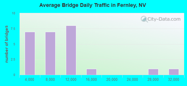
- 180,670Total average daily traffic
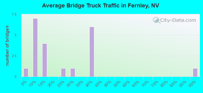
- 32,923Total average daily truck traffic
- National Bridge Inventory (NBI) Registered Bridges for Fernley
- No street view available for this location
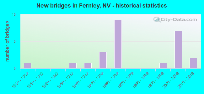
- New bridges - historical statistics
- 11900-1909
- 11930-1939
- 11940-1949
- 31950-1959
- 91960-1969
- 11990-1999
- 72000-2009
- 22010-2019
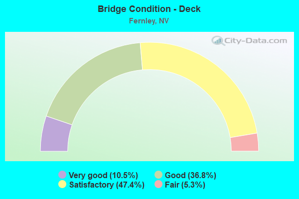
- Bridge Condition - Deck
- 10.5%Very good
- 36.8%Good
- 47.4%Satisfactory
- 5.3%Fair
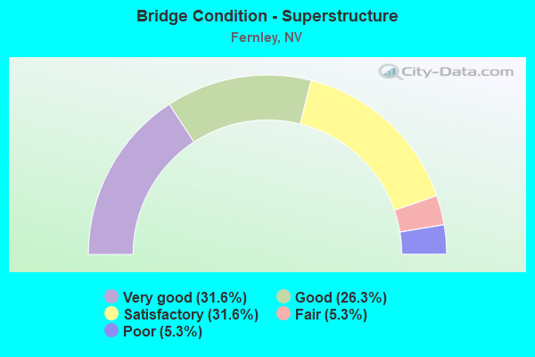
- Bridge Condition - Superstructure
- 31.6%Very good
- 26.3%Good
- 31.6%Satisfactory
- 5.3%Fair
- 5.3%Poor
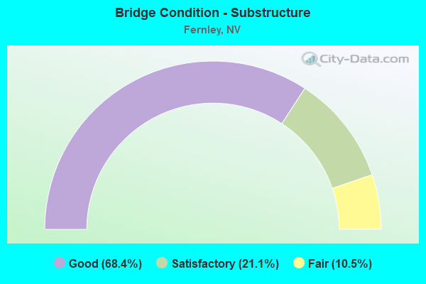
- Bridge Condition - Substructure
- 68.4%Good
- 21.1%Satisfactory
- 10.5%Fair
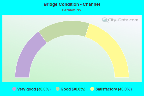
- Bridge Condition - Channel
- 30.0%Very good
- 30.0%Good
- 40.0%Satisfactory
Find on map >> Show street view
Structure Number: B 238, Location: FERNLEY (Lat: 39.591061, Lng: -119.250022), Route carried "on" structure: Alternate US 95, Year Built: 2006, Status: Open, Structure Length: 2.51m (8.23ft), Average Daily Traffic: 8,400 (year 2017), Truck Traffic: 6%, Average Future Daily Traffic: 15,000 (year 2040), Design Load: HS 20+Mod, Features Intersected: TRUCKEE CANAL
Minimum Vertical Clearance: 5.97m (19.59ft), Kilometerpoint: 92.091, Lanes on structure: 3, Owner: State Highway Agency, Approaching Roadway Width: 21.3m (69.9ft), Material/Design: Steel, Design/Construction: Stringer/Multi-beam, Number Of Spans In Main Unit: 1, Length of Maximum Span: 24.4m (80.1ft), Curb or Sidewalk Widths: Left: 1.5m (4.9ft), Right: 1.5m (4.9ft), Curb-To-Curb Width: 21.3m (69.9ft), Out-to-Out Width: 25.0m (82.0ft)
Condition: Deck: Good, Superstructure: Very good, Substructure: Good, Channel: Very good, Operating Rating: 82.5 metric tons, Method Used To Determine Operating Rating: Load Factor (LF), Inventory Rating: 49.6 metric tons, Method Used To Determine Inventory Rating: Load Factor (LF), Structural Evaluation: Better than present minimum criteria, Deck Geometry: Superior to present desirable criteria, Waterway Adequacy: Equal to present desirable criteria, Approach Roadway Alignment: Equal to present desirable criteria, Designated Inspection Frequency: Every 24 months, Inspection Date: Febuary 2021, Deck Structure Type: Concrete Cast-file-Place, Wearing Surface/Protective System: Wearing Surface: Epoxy Overlay, Deck Protection: Epoxy Coated Reinforcing
Find on map >> Show street view
Structure Number: B 608, Location: WEST OF FALLON NR LAHNTN (Lat: 39.469089, Lng: -119.066217), Route carried "on" structure: US 50, Year Built: 1957, Status: Open, Structure Length: 3.29m (10.79ft), Average Daily Traffic: 2,100 (year 2017), Truck Traffic: 6%, Average Future Daily Traffic: 3,900 (year 2040), Design Load: HS 20, Features Intersected: TRUCKEE CANAL
Minimum Vertical Clearance: 30+ m (98+ ft), Kilometerpoint: 113.290, Lanes on structure: 2, Base Highway Network: Yes, Owner: State Highway Agency, Approaching Roadway Width: 9.8m (32.2ft), Skew: 3 degrees, Material/Design: Steel continuous, Design/Construction: Stringer/Multi-beam, Number Of Spans In Main Unit: 3, Length of Maximum Span: 22.9m (75.1ft), Curb-To-Curb Width: 9.8m (32.2ft), Out-to-Out Width: 11.3m (37.1ft)
Condition: Deck: Satisfactory, Superstructure: Good, Substructure: Satisfactory, Channel: Good, Operating Rating: 49.3 metric tons, Method Used To Determine Operating Rating: Load Factor (LF), Inventory Rating: 29.7 metric tons, Method Used To Determine Inventory Rating: Load Factor (LF), Structural Evaluation: Equal to present minimum criteria, Deck Geometry: Meets minimum limits, Waterway Adequacy: Equal to present desirable criteria, Approach Roadway Alignment: Equal to present desirable criteria, Designated Inspection Frequency: Every 24 months, Inspection Date: March 2021, Deck Structure Type: Concrete Cast-file-Place, Wearing Surface/Protective System: Wearing Surface: Bituminous
Find on map >> Show street view
Structure Number: B 716E, Location: WEST OF FERNLEY (Lat: 39.617614, Lng: -119.293756), Route carried "on" structure: Interstate 80, Year Built: 1961, Status: Open, Structure Length: 9.54m (31.30ft), Average Daily Traffic: 13,500 (year 2017), Truck Traffic: 26%, Average Future Daily Traffic: 33,506 (year 2040), Design Load: HS 20+Mod, Features Intersected: TRUCKEE RVR
Minimum Vertical Clearance: 30+ m (98+ ft), Kilometerpoint: 71.897, Lanes on structure: 2, Base Highway Network: Yes, Owner: State Highway Agency, Approaching Roadway Width: 11.6m (38.1ft), Skew: 3 degrees, Material/Design: Prestressed concrete, Design/Construction: Tee Beam, Number Of Spans In Main Unit: 4, Length of Maximum Span: 23.8m (78.1ft), Curb-To-Curb Width: 11.6m (38.1ft), Out-to-Out Width: 13.1m (43.0ft)
Condition: Deck: Satisfactory, Superstructure: Satisfactory, Substructure: Satisfactory, Channel: Satisfactory, Operating Rating: 41.1 metric tons, Method Used To Determine Operating Rating: Load Factor (LF), Inventory Rating: 24.8 metric tons, Method Used To Determine Inventory Rating: Load Factor (LF), Structural Evaluation: Equal to present minimum criteria, Deck Geometry: Equal to present minimum criteria, Waterway Adequacy: Superior to present desirable criteria, Approach Roadway Alignment: Equal to present desirable criteria, Designated Inspection Frequency: Every 24 months, Underwater Inspection Frequency: Every 48 months, Inspection Date: May 2021, Underwater Inspection Date: August 2019, Deck Structure Type: Concrete Cast-file-Place, Wearing Surface/Protective System: Wearing Surface: Bituminous, Membrane: Preformed Fabric
Find on map >> Show street view
Structure Number: B169, Location: SOUTHWEST OF WADSWORTH (Lat: 39.590969, Lng: -119.367286), Route carried "on" structure: County highway , Year Built: 1902, Status: Posted for load, Structure Length: 4.82m (15.81ft), Average Daily Traffic: 134 (year 2017), Average Future Daily Traffic: 333 (year 2040), Features Intersected: TRUCKEE RVR, Facility Carried by Structure: PAINTED ROCK RD
Minimum Vertical Clearance: 5.64m (18.50ft), Kilometerpoint: 0.000, Lanes on structure: 1, Owner: County Highway Agency, Approaching Roadway Width: 7.3m (24.0ft), Material/Design: Steel, Design/Construction: Truss - Thru, Number Of Spans In Main Unit: 1, Length of Maximum Span: 44.8m (147.0ft), Curb-To-Curb Width: 4.0m (13.1ft), Out-to-Out Width: 5.5m (18.0ft)
Condition: Deck: Fair, Superstructure: Fair, Substructure: Satisfactory, Channel: Satisfactory, Operating Rating: 48.3 metric tons, Method Used To Determine Operating Rating: Load Factor (LF), Inventory Rating: 15.0 metric tons, Method Used To Determine Inventory Rating: Load Factor (LF), Structural Evaluation: Meets minimum limits, Deck Geometry: High priority of replacement, Waterway Adequacy: Equal to present desirable criteria, Approach Roadway Alignment: Equal to present minimum criteria, Length Of Structure Improvement: 5.83m (19.13ft), Designated Inspection Frequency: Every 12 months, Critical Feature Inspection Frequency: Every 12 months, Inspection Date: April 2021, Critical Feature Inspection Date: April 2021, Bridge Improvement Cost: $468,000, Roadway Improvement Cost: $47,000, Total Project Cost: $703,000, Deck Structure Type: Wood or Timber, Wearing Surface/Protective System: Wearing Surface: Wood or Timber
Find on map >> Show street view
Structure Number: B1706, Location: SOUTH OF HAZEN (Lat: 39.518847, Lng: -119.049964), Route carried "on" structure: County highway , Year Built: 1948, Status: Posted for load, Structure Length: 1.43m (4.69ft), Average Daily Traffic: 11 (year 2017), Average Future Daily Traffic: 27 (year 2040), Design Load: HS 20, Features Intersected: TRUCKEE-CARSON CANAL, Facility Carried by Structure: RURAL ROAD
Minimum Vertical Clearance: 30+ m (98+ ft), Kilometerpoint: 0.000, Lanes on structure: 1, Owner: Private, Approaching Roadway Width: 4.9m (16.1ft), Material/Design: Steel, Design/Construction: Girder and Floorbeam System, Number Of Spans In Main Unit: 1, Length of Maximum Span: 11.9m (39.0ft), Curb-To-Curb Width: 4.4m (14.4ft), Out-to-Out Width: 4.7m (15.4ft)
Condition: Deck: Satisfactory, Superstructure: Satisfactory, Substructure: Fair, Channel: Good, Operating Rating: 38.5 metric tons, Method Used To Determine Operating Rating: Load Factor (LF), Inventory Rating: 23.1 metric tons, Method Used To Determine Inventory Rating: Load Factor (LF), Structural Evaluation: Somewhat better than minimum adequacy, Deck Geometry: Equal to present minimum criteria, Waterway Adequacy: Superior to present desirable criteria, Approach Roadway Alignment: Equal to present minimum criteria, Bridge Posting: Required (Relationship of Operating Rating to Maximum Legal Load: > 39.9% below), Length Of Structure Improvement: 2.11m (6.92ft), Designated Inspection Frequency: Every 12 months, Critical Feature Inspection Frequency: Every 12 months, Other Special Inspection Frequency: Every 12 months, Inspection Date: January 2021, Critical Feature Inspection Date: January 2021, Other Special Inspection Date: January 2021, Bridge Improvement Cost: $169,000, Roadway Improvement Cost: $17,000, Total Project Cost: $254,000, Deck Structure Type: Wood or Timber, Wearing Surface/Protective System: Wearing Surface: Wood or Timber
Find on map >> Show street view
Structure Number: B1707, Location: NORTHWEST OF HAZEN (Lat: 39.576414, Lng: -119.104497), Route carried "on" structure: County highway , Year Built: 1955, Status: Posted for load, Structure Length: 1.52m (4.99ft), Average Daily Traffic: 274 (year 2017), Truck Traffic: 90%, Average Future Daily Traffic: 680 (year 2040), Design Load: H 15, Features Intersected: TRUCKEE-CARSON CANAL, Facility Carried by Structure: RURAL ROAD
Minimum Vertical Clearance: 30+ m (98+ ft), Kilometerpoint: 0.000, Lanes on structure: 1, Owner: Private, Approaching Roadway Width: 5.2m (17.1ft), Material/Design: Steel, Design/Construction: Girder and Floorbeam System, Number Of Spans In Main Unit: 1, Length of Maximum Span: 12.2m (40.0ft), Curb-To-Curb Width: 5.8m (19.0ft), Out-to-Out Width: 5.8m (19.0ft)
Condition: Deck: Satisfactory, Superstructure: Poor, Substructure: Fair, Channel: Good, Operating Rating: 33.9 metric tons, Method Used To Determine Operating Rating: Load Factor (LF), Inventory Rating: 20.2 metric tons, Method Used To Determine Inventory Rating: Load Factor (LF), Structural Evaluation: Meets minimum limits, Deck Geometry: High priority of corrective action, Waterway Adequacy: Superior to present desirable criteria, Approach Roadway Alignment: Equal to present minimum criteria, Bridge Posting: Required (Relationship of Operating Rating to Maximum Legal Load: > 39.9% below), Length Of Structure Improvement: 2.20m (7.22ft), Designated Inspection Frequency: Every 12 months, Critical Feature Inspection Frequency: Every 6 months, Inspection Date: August 2021, Critical Feature Inspection Date: August 2021, Bridge Improvement Cost: $177,000, Roadway Improvement Cost: $180,000, Total Project Cost: $357,000, Deck Structure Type: Wood or Timber, Wearing Surface/Protective System: Wearing Surface: Bituminous
Find on map >> Show street view
Structure Number: B2187, Location: FERNLEY HIGHLANDS (Lat: 39.580506, Lng: -119.147300), Route carried "on" structure: City street , Year Built: 1996, Status: Posted for load, Structure Length: 2.77m (9.09ft), Average Daily Traffic: 61 (year 2017), Average Future Daily Traffic: 151 (year 2040), Design Load: H 15, Features Intersected: TRUCKEE CARSON CANAL, Facility Carried by Structure: GUSTAFSON ROAD
Minimum Vertical Clearance: 30+ m (98+ ft), Kilometerpoint: 0.000, Lanes on structure: 1, Owner: City or Municipal Highway Agency, Approaching Roadway Width: 5.5m (18.0ft), Material/Design: Steel, Design/Construction: Girder and Floorbeam System, Number Of Spans In Main Unit: 1, Length of Maximum Span: 27.1m (88.9ft), Curb or Sidewalk Widths: Left: 1.1m (3.6ft), Right: 0.0m, Curb-To-Curb Width: 5.5m (18.0ft), Out-to-Out Width: 6.7m (22.0ft)
Condition: Deck: Good, Superstructure: Satisfactory, Substructure: Good, Channel: Satisfactory, Operating Rating: 29.7 metric tons, Method Used To Determine Operating Rating: Load Factor (LF), Inventory Rating: 18.0 metric tons, Method Used To Determine Inventory Rating: Load Factor (LF), Structural Evaluation: Somewhat better than minimum adequacy, Deck Geometry: Meets minimum limits, Waterway Adequacy: Superior to present desirable criteria, Approach Roadway Alignment: Equal to present desirable criteria, Bridge Posting: Required (Relationship of Operating Rating to Maximum Legal Load: 0.1 - 9.9% below), Designated Inspection Frequency: Every 12 months, Critical Feature Inspection Frequency: Every 12 months, Inspection Date: Febuary 2021, Critical Feature Inspection Date: Febuary 2021, Deck Structure Type: Steel plate, Wearing Surface/Protective System: Wearing Surface: Bituminous
Find on map >> Show street view
Structure Number: B3095, Location: South of Farm District Rd (Lat: 39.581303, Lng: -119.174369), Route carried "on" structure: City street , Year Built: 2004, Status: Open, Structure Length: 2.50m (8.20ft), Average Daily Traffic: 220 (year 2017), Average Future Daily Traffic: 546 (year 2040), Design Load: HL 93, Features Intersected: TRUCKEE CANAL, Facility Carried by Structure: CLEARWATER PKWY
Minimum Vertical Clearance: 30+ m (98+ ft), Kilometerpoint: 0.000, Lanes on structure: 2, Owner: City or Municipal Highway Agency, Approaching Roadway Width: 17.4m (57.1ft), Material/Design: Steel, Design/Construction: Stringer/Multi-beam, Number Of Spans In Main Unit: 1, Length of Maximum Span: 25.0m (82.0ft), Curb or Sidewalk Widths: Left: 1.4m (4.6ft), Right: 1.4m (4.6ft), Curb-To-Curb Width: 17.4m (57.1ft), Out-to-Out Width: 20.7m (67.9ft)
Condition: Deck: Good, Superstructure: Very good, Substructure: Good, Channel: Very good, Operating Rating: 86.8 metric tons, Method Used To Determine Operating Rating: Load and Resistance Factor (LRFR), Inventory Rating: 66.9 metric tons, Method Used To Determine Inventory Rating: Load and Resistance Factor (LRFR), Structural Evaluation: Better than present minimum criteria, Deck Geometry: Superior to present desirable criteria, Waterway Adequacy: Equal to present desirable criteria, Approach Roadway Alignment: Better than present minimum criteria, Designated Inspection Frequency: Every 24 months, Inspection Date: Febuary 2021, Deck Structure Type: Concrete Cast-file-Place, Wearing Surface/Protective System: Wearing Surface: Monolithic Concrete
Find on map >> Show street view
Structure Number: B3199, Location: 4.61 Miles from US50 (Lat: 39.430244, Lng: -119.336108), Route carried "on" structure: Bypass State highway 439, Year Built: 2017, Status: Open, Structure Length: 1.22m (4.00ft), Average Daily Traffic: 5,400 (year 2017), Truck Traffic: 12%, Average Future Daily Traffic: 12,410 (year 2040), Design Load: HL 93, Features Intersected: WASH
Minimum Vertical Clearance: 30+ m (98+ ft), Kilometerpoint: 4.635, Lanes on structure: 4, Owner: State Highway Agency, Approaching Roadway Width: 21.9m (71.9ft), Skew: 10 degrees, Material/Design: Concrete, Design/Construction: Culvert, Number Of Spans In Main Unit: 3, Length of Maximum Span: 3.7m (12.1ft), Curb-To-Curb Width: 21.9m (71.9ft), Out-to-Out Width: 21.9m (71.9ft)
Condition: Channel: Satisfactory, Culverts: Good, Structural Evaluation: Better than present minimum criteria, Deck Geometry: Superior to present desirable criteria, Waterway Adequacy: Equal to present desirable criteria, Approach Roadway Alignment: Equal to present desirable criteria, Designated Inspection Frequency: Every 48 months, Inspection Date: June 2021
Find on map >> Show street view
Structure Number: B3201, Location: 8.66 Miles N of US50 - 0. (Lat: 39.469556, Lng: -119.390467), Route carried "on" structure: Alternate State highway 439, Year Built: 2017, Status: Open, Structure Length: 0.61m (2.00ft), Average Daily Traffic: 5,400 (year 2017), Truck Traffic: 12%, Average Future Daily Traffic: 12,410 (year 2040), Design Load: HL 93, Features Intersected: WILDLIFE UNDERCROSSING
Minimum Vertical Clearance: 30+ m (98+ ft), Kilometerpoint: 1.609, Lanes on structure: 4, Owner: State Highway Agency, Approaching Roadway Width: 11.0m (36.1ft), Skew: 30 degrees, Material/Design: Concrete, Design/Construction: Culvert, Number Of Spans In Main Unit: 1, Length of Maximum Span: 6.1m (20.0ft), Curb-To-Curb Width: 11.0m (36.1ft), Out-to-Out Width: 11.0m (36.1ft)
Condition: Channel: Very good, Culverts: Good, Structural Evaluation: Better than present minimum criteria, Deck Geometry: High priority of replacement, Waterway Adequacy: Equal to present desirable criteria, Approach Roadway Alignment: Equal to present desirable criteria, Designated Inspection Frequency: Every 48 months, Inspection Date: June 2021
Find on map >> Show street view
Structure Number: G 19, Location: FERNLEY (Lat: 39.604889, Lng: -119.226281), Route carried "on" structure: Alternate US 95, Year Built: 2006, Status: Open, Structure Length: 7.86m (25.79ft), Average Daily Traffic: 28,000 (year 2017), Truck Traffic: 5%, Average Future Daily Traffic: 51,000 (year 2040), Design Load: HS 20+Mod, Features Intersected: UPRR
Minimum Vertical Clearance: 30+ m (98+ ft), Kilometerpoint: 96.181, Lanes on structure: 4, Owner: State Highway Agency, Approaching Roadway Width: 18.8m (61.7ft), Skew: 23 degrees, Material/Design: Steel continuous, Design/Construction: Stringer/Multi-beam, Number Of Spans In Main Unit: 3, Length of Maximum Span: 35.1m (115.2ft), Curb or Sidewalk Widths: Left: 1.6m (5.2ft), Right: 1.6m (5.2ft), Curb-To-Curb Width: 21.9m (71.9ft), Out-to-Out Width: 26.2m (86.0ft)
Condition: Deck: Good, Superstructure: Good, Substructure: Good, Inventory Rating: 59.0 metric tons, Method Used To Determine Inventory Rating: Load Factor (LF), Structural Evaluation: Better than present minimum criteria, Deck Geometry: Superior to present desirable criteria, Underclear: Superior to present desirable criteria, Approach Roadway Alignment: Equal to present desirable criteria, Designated Inspection Frequency: Every 24 months, Inspection Date: June 2021, Deck Structure Type: Concrete Cast-file-Place, Wearing Surface/Protective System: Wearing Surface: Monolithic Concrete, Deck Protection: Epoxy Coated Reinforcing
Find on map >> Show street view
Structure Number: G 843E, Location: NEAR FERNLEY (Lat: 39.615658, Lng: -119.262725), Route carried "on" structure: Interstate 80, Year Built: 1963, Status: Open, Structure Length: 5.61m (18.41ft), Average Daily Traffic: 9,750 (year 2017), Truck Traffic: 36%, Average Future Daily Traffic: 24,199 (year 2040), Design Load: HS 20+Mod, Features Intersected: SPRR
Minimum Vertical Clearance: 30+ m (98+ ft), Kilometerpoint: 74.614, Lanes on structure: 2, Base Highway Network: Yes, Owner: State Highway Agency, Approaching Roadway Width: 13.4m (44.0ft), Skew: 3 degrees, Material/Design: Prestressed concrete, Design/Construction: Tee Beam, Number Of Spans In Main Unit: 3, Length of Maximum Span: 18.3m (60.0ft), Curb-To-Curb Width: 13.4m (44.0ft), Out-to-Out Width: 14.9m (48.9ft)
Condition: Deck: Very good, Superstructure: Very good, Substructure: Good, Operating Rating: 48.6 metric tons, Method Used To Determine Operating Rating: Load Factor (LF), Inventory Rating: 24.8 metric tons, Method Used To Determine Inventory Rating: Load Factor (LF), Structural Evaluation: Equal to present minimum criteria, Deck Geometry: Superior to present desirable criteria, Underclear: Equal to present minimum criteria, Approach Roadway Alignment: Equal to present desirable criteria, Designated Inspection Frequency: Every 24 months, Inspection Date: May 2021, Deck Structure Type: Concrete Cast-file-Place, Wearing Surface/Protective System: Wearing Surface: Bituminous, Membrane: Preformed Fabric
Find on map >> Show street view
Structure Number: G 843W, Location: NEAR FERNLEY (Lat: 39.616050, Lng: -119.262956), Route carried "on" structure: Interstate 80, Year Built: 1963, Status: Open, Structure Length: 5.61m (18.41ft), Average Daily Traffic: 9,750 (year 2017), Truck Traffic: 36%, Average Future Daily Traffic: 30,000 (year 2040), Design Load: HS 20+Mod, Features Intersected: SPRR
Minimum Vertical Clearance: 30+ m (98+ ft), Kilometerpoint: 74.614, Lanes on structure: 2, Base Highway Network: Yes, Owner: State Highway Agency, Approaching Roadway Width: 13.4m (44.0ft), Skew: 3 degrees, Material/Design: Prestressed concrete, Design/Construction: Tee Beam, Number Of Spans In Main Unit: 3, Length of Maximum Span: 18.3m (60.0ft), Curb-To-Curb Width: 13.4m (44.0ft), Out-to-Out Width: 14.9m (48.9ft)
Condition: Deck: Very good, Superstructure: Very good, Substructure: Good, Operating Rating: 48.6 metric tons, Method Used To Determine Operating Rating: Load Factor (LF), Inventory Rating: 24.8 metric tons, Method Used To Determine Inventory Rating: Load Factor (LF), Structural Evaluation: Equal to present minimum criteria, Deck Geometry: Superior to present desirable criteria, Underclear: Equal to present minimum criteria, Approach Roadway Alignment: Equal to present desirable criteria, Designated Inspection Frequency: Every 24 months, Inspection Date: May 2021, Deck Structure Type: Concrete Cast-file-Place, Wearing Surface/Protective System: Wearing Surface: Bituminous, Membrane: Preformed Fabric
Find on map >> Show street view
Structure Number: G2845E, Location: HAZEN (Lat: 39.559319, Lng: -119.039056), Route carried "on" structure: US 50, Year Built: 2008, Status: Open, Structure Length: 6.42m (21.06ft), Average Daily Traffic: 4,600 (year 2017), Truck Traffic: 10%, Average Future Daily Traffic: 11,417 (year 2040), Design Load: HS 20+Mod, Features Intersected: UPRR
Minimum Vertical Clearance: 30+ m (98+ ft), Kilometerpoint: 83.704, Lanes on structure: 2, Base Highway Network: Yes, Owner: State Highway Agency, Approaching Roadway Width: 13.0m (42.7ft), Skew: 4 degrees, Material/Design: Steel, Design/Construction: Stringer/Multi-beam, Number Of Spans In Main Unit: 3, Length of Maximum Span: 26.5m (86.9ft), Curb-To-Curb Width: 13.0m (42.7ft), Out-to-Out Width: 13.7m (44.9ft)
Condition: Deck: Satisfactory, Superstructure: Very good, Substructure: Good, Operating Rating: 48.0 metric tons, Method Used To Determine Operating Rating: Load Factor (LF), Inventory Rating: 36.8 metric tons, Method Used To Determine Inventory Rating: Load Factor (LF), Structural Evaluation: Better than present minimum criteria, Deck Geometry: Superior to present desirable criteria, Underclear: Superior to present desirable criteria, Approach Roadway Alignment: Equal to present desirable criteria, Designated Inspection Frequency: Every 24 months, Inspection Date: March 2020, Deck Structure Type: Concrete Cast-file-Place, Wearing Surface/Protective System: Wearing Surface: Monolithic Concrete
Find on map >> Show street view
Structure Number: G2845W, Location: HAZEN (Lat: 39.559611, Lng: -119.039122), Route carried "on" structure: US 50, Year Built: 2008, Status: Open, Structure Length: 6.42m (21.06ft), Average Daily Traffic: 4,600 (year 2017), Truck Traffic: 10%, Average Future Daily Traffic: 11,417 (year 2040), Design Load: HS 20+Mod, Features Intersected: UPRR
Minimum Vertical Clearance: 30+ m (98+ ft), Kilometerpoint: 83.704, Lanes on structure: 2, Base Highway Network: Yes, Owner: State Highway Agency, Approaching Roadway Width: 13.0m (42.7ft), Skew: 4 degrees, Material/Design: Steel, Design/Construction: Stringer/Multi-beam, Number Of Spans In Main Unit: 3, Length of Maximum Span: 26.5m (86.9ft), Curb-To-Curb Width: 13.0m (42.7ft), Out-to-Out Width: 13.7m (44.9ft)
Condition: Deck: Satisfactory, Superstructure: Very good, Substructure: Good, Operating Rating: 48.0 metric tons, Method Used To Determine Operating Rating: Load Factor (LF), Inventory Rating: 36.8 metric tons, Method Used To Determine Inventory Rating: Load Factor (LF), Structural Evaluation: Better than present minimum criteria, Deck Geometry: Superior to present desirable criteria, Underclear: Superior to present desirable criteria, Approach Roadway Alignment: Equal to present desirable criteria, Designated Inspection Frequency: Every 24 months, Inspection Date: March 2020, Deck Structure Type: Concrete Cast-file-Place, Wearing Surface/Protective System: Wearing Surface: Monolithic Concrete
Find on map >> Show street view
Structure Number: H 844E, Location: NEAR FERNLEY (Lat: 39.614489, Lng: -119.236156), Route carried "on" structure: Interstate 80, Year Built: 1963, Status: Open, Structure Length: 2.83m (9.28ft), Average Daily Traffic: 9,750 (year 2017), Truck Traffic: 35%, Average Future Daily Traffic: 8,500 (year 2040), Design Load: HS 20+Mod, Features Intersected: VINE ST GRADE SEP MP47
Minimum Vertical Clearance: 30+ m (98+ ft), Kilometerpoint: 76.769, Lanes on structure: 2, Lanes under structure: 2, Base Highway Network: Yes, Owner: State Highway Agency, Approaching Roadway Width: 11.6m (38.1ft), Material/Design: Concrete continuous, Design/Construction: Slab, Number Of Spans In Main Unit: 3, Length of Maximum Span: 10.7m (35.1ft), Curb or Sidewalk Widths: Left: 0.5m (1.6ft), Right: 0.5m (1.6ft), Curb-To-Curb Width: 11.6m (38.1ft), Out-to-Out Width: 13.1m (43.0ft)
Condition: Deck: Good, Superstructure: Good, Substructure: Good, Operating Rating: 76.0 metric tons, Method Used To Determine Operating Rating: Load Factor (LF), Inventory Rating: 45.4 metric tons, Method Used To Determine Inventory Rating: Load Factor (LF), Structural Evaluation: Better than present minimum criteria, Deck Geometry: Equal to present minimum criteria, Underclear: Meets minimum limits, Approach Roadway Alignment: Equal to present desirable criteria, Designated Inspection Frequency: Every 24 months, Inspection Date: May 2021, Deck Structure Type: Concrete Cast-file-Place, Wearing Surface/Protective System: Wearing Surface: Bituminous, Membrane: Other
Find on map >> Show street view
Structure Number: H 844W, Location: NEAR FERNLEY (Lat: 39.614844, Lng: -119.236214), Route carried "on" structure: Interstate 80, Year Built: 1963, Status: Open, Structure Length: 2.83m (9.28ft), Average Daily Traffic: 9,750 (year 2017), Truck Traffic: 35%, Average Future Daily Traffic: 8,500 (year 2040), Design Load: HS 20+Mod, Features Intersected: VINE ST GRADE SEP MP47
Minimum Vertical Clearance: 30+ m (98+ ft), Kilometerpoint: 76.769, Lanes on structure: 2, Lanes under structure: 2, Base Highway Network: Yes, Owner: State Highway Agency, Approaching Roadway Width: 11.6m (38.1ft), Material/Design: Concrete continuous, Design/Construction: Slab, Number Of Spans In Main Unit: 3, Length of Maximum Span: 10.7m (35.1ft), Curb or Sidewalk Widths: Left: 0.5m (1.6ft), Right: 0.5m (1.6ft), Curb-To-Curb Width: 11.6m (38.1ft), Out-to-Out Width: 13.1m (43.0ft)
Condition: Deck: Good, Superstructure: Good, Substructure: Good, Operating Rating: 76.0 metric tons, Method Used To Determine Operating Rating: Load Factor (LF), Inventory Rating: 45.4 metric tons, Method Used To Determine Inventory Rating: Load Factor (LF), Structural Evaluation: Better than present minimum criteria, Deck Geometry: Equal to present minimum criteria, Underclear: Meets minimum limits, Approach Roadway Alignment: Equal to present desirable criteria, Designated Inspection Frequency: Every 24 months, Inspection Date: May 2021, Deck Structure Type: Concrete Cast-file-Place, Wearing Surface/Protective System: Wearing Surface: Bituminous, Membrane: Other
Find on map >> Show street view
Structure Number: I 671, Location: WEST OF WADSWORTH (Lat: 39.591411, Lng: -119.369683), Route carried "on" structure: Interstate 80, Year Built: 1958, Status: Open, Structure Length: 1.01m (3.31ft), Average Daily Traffic: 25,000 (year 2017), Truck Traffic: 22%, Average Future Daily Traffic: 62,048 (year 2040), Design Load: HS 20+Mod, Features Intersected: PAINTED ROCK EXIT 40
Minimum Vertical Clearance: 30+ m (98+ ft), Kilometerpoint: 64.506, Lanes on structure: 4, Lanes under structure: 2, Base Highway Network: Yes, Owner: State Highway Agency, Approaching Roadway Width: 23.2m (76.1ft), Skew: 30 degrees, Material/Design: Concrete, Design/Construction: Frame, Number Of Spans In Main Unit: 1, Length of Maximum Span: 9.1m (29.9ft), Curb-To-Curb Width: 23.2m (76.1ft), Out-to-Out Width: 32.9m (107.9ft)
Condition: Deck: Satisfactory, Superstructure: Satisfactory, Substructure: Good, Inventory Rating: 70.8 metric tons, Method Used To Determine Inventory Rating: Load Factor (LF), Structural Evaluation: Equal to present minimum criteria, Deck Geometry: Superior to present desirable criteria, Underclear: High priority of corrective action, Approach Roadway Alignment: Equal to present desirable criteria, Designated Inspection Frequency: Every 24 months, Inspection Date: May 2021, Deck Structure Type: Concrete Cast-file-Place
Find on map >> Show street view
Structure Number: I 740E, Location: FERNLEY (Lat: 39.613144, Lng: -119.218103), Route carried "on" structure: Interstate 80, Year Built: 1963, Year Reconstructed: 1972, Status: Open, Structure Length: 4.08m (13.39ft), Average Daily Traffic: 4,150 (year 2017), Truck Traffic: 39%, Average Future Daily Traffic: 10,300 (year 2040), Design Load: HS 20+Mod, Features Intersected: US 95A
Minimum Vertical Clearance: 30+ m (98+ ft), Kilometerpoint: 78.470, Lanes on structure: 2, Lanes under structure: 2, Base Highway Network: Yes, Owner: State Highway Agency, Approaching Roadway Width: 11.6m (38.1ft), Skew: 3 degrees, Material/Design: Concrete continuous, Design/Construction: Box Beam or Girders - Single/Spread, Number Of Spans In Main Unit: 3, Length of Maximum Span: 15.8m (51.8ft), Curb-To-Curb Width: 11.6m (38.1ft), Out-to-Out Width: 13.1m (43.0ft)
Condition: Deck: Satisfactory, Superstructure: Satisfactory, Substructure: Satisfactory, Operating Rating: 55.1 metric tons, Method Used To Determine Operating Rating: Load Factor (LF), Inventory Rating: 32.9 metric tons, Method Used To Determine Inventory Rating: Load Factor (LF), Structural Evaluation: Equal to present minimum criteria, Deck Geometry: Equal to present minimum criteria, Underclear: Meets minimum limits, Approach Roadway Alignment: Equal to present desirable criteria, Designated Inspection Frequency: Every 24 months, Inspection Date: May 2021, Deck Structure Type: Concrete Cast-file-Place, Wearing Surface/Protective System: Wearing Surface: Bituminous, Membrane: Other
Find on map >> Show street view
Structure Number: I 740W, Location: FERNLEY (Lat: 39.613531, Lng: -119.217900), Route carried "on" structure: Interstate 80, Year Built: 1963, Year Reconstructed: 1972, Status: Open, Structure Length: 4.08m (13.39ft), Average Daily Traffic: 4,150 (year 2017), Truck Traffic: 39%, Average Future Daily Traffic: 10,300 (year 2040), Design Load: HS 20+Mod, Features Intersected: US 95A
Minimum Vertical Clearance: 30+ m (98+ ft), Kilometerpoint: 78.470, Lanes on structure: 2, Lanes under structure: 2, Base Highway Network: Yes, Owner: State Highway Agency, Approaching Roadway Width: 11.6m (38.1ft), Skew: 3 degrees, Material/Design: Concrete continuous, Design/Construction: Box Beam or Girders - Single/Spread, Number Of Spans In Main Unit: 3, Length of Maximum Span: 15.8m (51.8ft), Curb-To-Curb Width: 11.6m (38.1ft), Out-to-Out Width: 13.1m (43.0ft)
Condition: Deck: Satisfactory, Superstructure: Satisfactory, Substructure: Good, Operating Rating: 55.1 metric tons, Method Used To Determine Operating Rating: Load Factor (LF), Inventory Rating: 32.9 metric tons, Method Used To Determine Inventory Rating: Load Factor (LF), Structural Evaluation: Equal to present minimum criteria, Deck Geometry: Equal to present minimum criteria, Underclear: Meets minimum limits, Approach Roadway Alignment: Equal to present desirable criteria, Designated Inspection Frequency: Every 24 months, Inspection Date: May 2021, Deck Structure Type: Concrete Cast-file-Place, Wearing Surface/Protective System: Wearing Surface: Bituminous, Membrane: Other
Find on map >> Show street view
Structure Number: I2921, Location: EAST OF FERNLEY (Lat: 39.623278, Lng: -119.200900), Route carried "on" structure: City street , Year Built: 2009, Status: Open, Structure Length: 5.80m (19.03ft), Average Daily Traffic: 1,500 (year 2017), Truck Traffic: 3%, Average Future Daily Traffic: 12,500 (year 2040), Design Load: HS 20+Mod, Features Intersected: I 80, Facility Carried by Structure: NEVADA PACIFIC PKW
Minimum Vertical Clearance: 30+ m (98+ ft), Kilometerpoint: 0.000, Lanes on structure: 2, Lanes under structure: 4, Owner: State Highway Agency, Approaching Roadway Width: 14.0m (45.9ft), Skew: 20 degrees, Material/Design: Steel continuous, Design/Construction: Stringer/Multi-beam, Number Of Spans In Main Unit: 2, Length of Maximum Span: 28.3m (92.8ft), Curb or Sidewalk Widths: Left: 1.7m (5.6ft), Right: 0.0m, Curb-To-Curb Width: 14.0m (45.9ft), Out-to-Out Width: 16.5m (54.1ft)
Condition: Deck: Good, Superstructure: Good, Substructure: Good, Operating Rating: 75.1 metric tons, Method Used To Determine Operating Rating: Load Factor (LF), Inventory Rating: 44.7 metric tons, Method Used To Determine Inventory Rating: Load Factor (LF), Structural Evaluation: Better than present minimum criteria, Deck Geometry: Superior to present desirable criteria, Underclear: Meets minimum limits, Approach Roadway Alignment: Equal to present desirable criteria, Designated Inspection Frequency: Every 24 months, Inspection Date: May 2021, Deck Structure Type: Concrete Cast-file-Place, Wearing Surface/Protective System: Wearing Surface: Monolithic Concrete, Deck Protection: Epoxy Coated Reinforcing
Find on map >> Show street view
Structure Number: G 18, Location: FERNLEY (Lat: 39.612494, Lng: -119.265189), Route carried "under" structure: Alternate US 95, Year Built: 1935, Structure Length: 0. m, Average Daily Traffic: 11,000 (year 2017), Truck Traffic: 7%, Features Intersected: US 95A, Facility Carried by Structure: SPRR
Minimum Vertical Clearance: 4.97m (16.31ft), Kilometerpoint: 0.000, Lanes under structure: 2, Material/Design: Steel, Design/Construction: Stringer/Multi-beam, Length of Maximum Span: 9.1m (29.9ft)
Find on map >> Show street view
Structure Number: I 740E, Location: FERNLEY (Lat: 39.613144, Lng: -119.218103), Route carried "under" structure: Alternate State highway 95, Year Built: 1963, Structure Length: 0. m, Average Daily Traffic: 8,185 (year 2009), Truck Traffic: 6%, Features Intersected: US 95A, Facility Carried by Structure: I 80E
Minimum Vertical Clearance: 4.88m (16.01ft), Kilometerpoint: 78.470, Lanes on structure: 2, Lanes under structure: 2, Material/Design: Concrete continuous, Design/Construction: Box Beam or Girders - Single/Spread, Length of Maximum Span: 15.8m (51.8ft)
Find on map >> Show street view
Structure Number: I 740W, Location: FERNLEY (Lat: 39.613531, Lng: -119.217900), Route carried "under" structure: Alternate State highway 95, Year Built: 1963, Structure Length: 0. m, Average Daily Traffic: 8,185 (year 2009), Truck Traffic: 6%, Features Intersected: US 95A, Facility Carried by Structure: I 80W
Minimum Vertical Clearance: 4.76m (15.62ft), Kilometerpoint: 78.470, Lanes on structure: 2, Lanes under structure: 2, Material/Design: Concrete continuous, Design/Construction: Box Beam or Girders - Single/Spread, Length of Maximum Span: 15.8m (51.8ft)
Find on map >> Show street view
Structure Number: I2921, Location: EAST OF FERNLEY (Lat: 39.623278, Lng: -119.200900), Route carried "under" structure: Interstate 80, Year Built: 2009, Structure Length: 0. m, Average Daily Traffic: 6,800 (year 2009), Truck Traffic: 8%, Features Intersected: I 80, Facility Carried by Structure: NEVADA PACIFIC PKW
Minimum Vertical Clearance: 5.49m (18.01ft), Kilometerpoint: 0.000, Lanes on structure: 2, Lanes under structure: 4, Material/Design: Steel continuous, Design/Construction: Stringer/Multi-beam, Length of Maximum Span: 28.3m (92.8ft)