Bridge Statistics for Federalsburg, Maryland (MD)
Condition, Traffic, Stress, Structural Evaluation, Project Costs
- National Bridge Inventory (NBI) Statistics
- 10Number of bridges
- 85ft / 25.7mTotal length
- $3,048,000Total costs
- 26,044Total average daily traffic
- 1,770Total average daily truck traffic
- 41,895Total future (year 2026) average daily traffic
- National Bridge Inventory (NBI) Registered Bridges for Federalsburg
- No street view available for this location
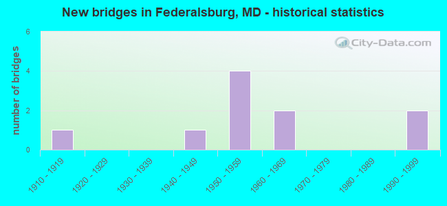
- New bridges - historical statistics
- 11910-1919
- 11940-1949
- 41950-1959
- 21960-1969
- 21990-1999

- Reconstructed bridges - Historical Statistics
- 11930-1939
- 01940-1949
- 01950-1959
- 11960-1969
- 01970-1979
- 01980-1989
- 01990-1999
- 12000-2009


- Bridge Condition - Deck
- 37.5%Good
- 37.5%Satisfactory
- 12.5%Fair
- 12.5%Poor

- Bridge Condition - Superstructure
- 37.5%Good
- 25.0%Satisfactory
- 37.5%Fair

- Bridge Condition - Substructure
- 25.0%Good
- 37.5%Satisfactory
- 12.5%Fair
- 25.0%Serious

- Bridge Condition - Channel
- 30.0%Very good
- 20.0%Good
- 50.0%Satisfactory
Find on map >> Show street view
Structure Number: 10000005000901, Location: 1.2 MILE NORTH OF MD 315 (Lat: 38.713389, Lng: -75.788406), Route carried "on" structure: State highway 313, Year Built: 1955, Status: Open, Structure Length: 1.98m (6.50ft), Average Daily Traffic: 5,080 (year 2009), Truck Traffic: 8%, Average Future Daily Traffic: 6,434 (year 2026), Design Load: H 20, Features Intersected: FAULKNER BRANCH
Minimum Vertical Clearance: 30+ m (98+ ft), Kilometerpoint: 7.385, Lanes on structure: 2, Base Highway Network: Yes, Owner: State Highway Agency, Approaching Roadway Width: 12.2m (40.0ft), Skew: 1 degrees, Material/Design: Steel, Design/Construction: Stringer/Multi-beam, Number Of Spans In Main Unit: 1, Length of Maximum Span: 18.3m (60.0ft), Curb or Sidewalk Widths: Left: 0.9m (3.0ft), Right: 0.9m (3.0ft), Curb-To-Curb Width: 9.1m (29.9ft), Out-to-Out Width: 11.6m (38.1ft)
Condition: Deck: Satisfactory, Superstructure: Satisfactory, Substructure: Good, Channel: Very good, Operating Rating: 51.7 metric tons, Method Used To Determine Operating Rating: Load Factor (LF), Inventory Rating: 30.8 metric tons, Method Used To Determine Inventory Rating: Load Factor (LF), Structural Evaluation: Equal to present minimum criteria, Deck Geometry: High priority of corrective action, Waterway Adequacy: Superior to present desirable criteria, Approach Roadway Alignment: Equal to present desirable criteria, Length Of Structure Improvement: 1.98m (6.50ft), Designated Inspection Frequency: Every 24 months, Inspection Date: September 2020, Bridge Improvement Cost: $148,000, Roadway Improvement Cost: $15,000, Total Project Cost: $163,000, Deck Structure Type: Concrete Cast-file-Place, Wearing Surface/Protective System: Wearing Surface: Bituminous
Find on map >> Show street view
Structure Number: 10000005002201, Location: 1.71 MILE SOUTH OF MD 308 (Lat: 38.686892, Lng: -75.770172), Route carried "on" structure: State highway 313, Year Built: 1962, Year Reconstructed: 2013, Status: Open, Structure Length: 8.32m (27.30ft), Average Daily Traffic: 8,633 (year 2012), Truck Traffic: 8%, Average Future Daily Traffic: 10,066 (year 2026), Features Intersected: MARSHYHOPE CREEK
Minimum Vertical Clearance: 30+ m (98+ ft), Kilometerpoint: 2.381, Lanes on structure: 2, Base Highway Network: Yes, Owner: State Highway Agency, Approaching Roadway Width: 9.8m (32.2ft), Material/Design: Steel, Design/Construction: Stringer/Multi-beam, Number Of Spans In Main Unit: 6, Length of Maximum Span: 13.7m (44.9ft), Curb or Sidewalk Widths: Left: 0.5m (1.6ft), Right: 0.5m (1.6ft), Curb-To-Curb Width: 9.8m (32.2ft), Out-to-Out Width: 10.9m (35.8ft)
Condition: Deck: Good, Superstructure: Good, Substructure: Satisfactory, Channel: Very good, Operating Rating: 69.8 metric tons, Method Used To Determine Operating Rating: Load Factor (LF), Inventory Rating: 41.7 metric tons, Method Used To Determine Inventory Rating: Load Factor (LF), Structural Evaluation: Equal to present minimum criteria, Deck Geometry: Meets minimum limits, Waterway Adequacy: Superior to present desirable criteria, Approach Roadway Alignment: Equal to present desirable criteria, Length Of Structure Improvement: 8.29m (27.20ft), Designated Inspection Frequency: Every 24 months, Underwater Inspection Frequency: Every 48 months, Inspection Date: December 2020, Underwater Inspection Date: June 2019, Bridge Improvement Cost: $579,000, Roadway Improvement Cost: $58,000, Total Project Cost: $637,000, Deck Structure Type: Concrete Cast-file-Place, Wearing Surface/Protective System: Wearing Surface: Latex Concrete, Membrane: Other
Find on map >> Show street view
Structure Number: 10000005003001, Location: 1.11 MILE EAST OF MD 313 (Lat: 38.694439, Lng: -75.772592), Route carried "on" structure: State highway 315, Year Built: 1910, Year Reconstructed: 1936, Status: Posted for load, Structure Length: 6.34m (20.80ft), Average Daily Traffic: 5,080 (year 2009), Truck Traffic: 8%, Average Future Daily Traffic: 6,353 (year 2026), Features Intersected: MARSHYHOPE CREEK
Minimum Vertical Clearance: 30+ m (98+ ft), Kilometerpoint: 1.786, Lanes on structure: 2, Owner: State Highway Agency, Approaching Roadway Width: 7.3m (24.0ft), Material/Design: Concrete, Design/Construction: Arch - Deck, Number Of Spans In Main Unit: 4, Length of Maximum Span: 15.2m (49.9ft), Curb or Sidewalk Widths: Left: 0.0m, Right: 1.5m (4.9ft), Curb-To-Curb Width: 7.3m (24.0ft), Out-to-Out Width: 9.8m (32.2ft)
Condition: Deck: Fair, Superstructure: Fair, Substructure: Satisfactory, Channel: Very good, Operating Rating: 42.2 metric tons, Method Used To Determine Operating Rating: Load Testing, Inventory Rating: 25.4 metric tons, Method Used To Determine Inventory Rating: Load Testing, Structural Evaluation: Somewhat better than minimum adequacy, Deck Geometry: High priority of replacement, Waterway Adequacy: Somewhat better than minimum adequacy, Approach Roadway Alignment: Equal to present desirable criteria, Bridge Posting: Required (Relationship of Operating Rating to Maximum Legal Load: > 39.9% below), Length Of Structure Improvement: 6.58m (21.59ft), Designated Inspection Frequency: Every 12 months, Underwater Inspection Frequency: Every 48 months, Inspection Date: June 2021, Underwater Inspection Date: August 2021, Bridge Improvement Cost: $835,000, Roadway Improvement Cost: $84,000, Total Project Cost: $919,000, Deck Structure Type: Concrete Cast-file-Place, Wearing Surface/Protective System: Wearing Surface: Bituminous
Find on map >> Show street view
Structure Number: 10000005003103, Location: 0.1 M W OF TURNER ROAD (Lat: 38.732881, Lng: -75.729136), Route carried "on" structure: State highway 306, Year Built: 1955, Status: Open, Structure Length: 0.79m (2.59ft), Average Daily Traffic: 282 (year 2009), Truck Traffic: 8%, Average Future Daily Traffic: 522 (year 2026), Features Intersected: HOUSTON BRANCH
Minimum Vertical Clearance: 30+ m (98+ ft), Kilometerpoint: 5.004, Lanes on structure: 2, Owner: State Highway Agency, Approaching Roadway Width: 6.7m (22.0ft), Skew: 1 degrees, Material/Design: Steel, Design/Construction: Culvert, Number Of Spans In Main Unit: 1, Length of Maximum Span: 1.5m (4.9ft)
Condition: Channel: Satisfactory, Culverts: Fair, Structural Evaluation: Somewhat better than minimum adequacy, Waterway Adequacy: Better than present minimum criteria, Approach Roadway Alignment: Equal to present desirable criteria, Designated Inspection Frequency: Every 24 months, Inspection Date: March 2021, Wearing Surface/Protective System: Wearing Surface: Bituminous
Find on map >> Show street view
Structure Number: 200000CO003501, Location: 0.8 MILES NORTH OF MD 318 (Lat: 38.710075, Lng: -75.817606), Route carried "on" structure: County highway 209, Year Built: 1994, Status: Open, Structure Length: 1.25m (4.10ft), Average Daily Traffic: 342 (year 2020), Truck Traffic: 1%, Average Future Daily Traffic: 910 (year 2040), Design Load: HS 20, Features Intersected: FAULKNER BRANCH, Facility Carried by Structure: PEPPER ROAD
Minimum Vertical Clearance: 30+ m (98+ ft), Kilometerpoint: 1.352, Lanes on structure: 2, Owner: County Highway Agency, Approaching Roadway Width: 5.5m (18.0ft), Material/Design: Wood or Timber, Design/Construction: Slab, Number Of Spans In Main Unit: 2, Length of Maximum Span: 6.4m (21.0ft), Curb-To-Curb Width: 9.2m (30.2ft), Out-to-Out Width: 9.8m (32.2ft)
Condition: Deck: Good, Superstructure: Good, Substructure: Satisfactory, Channel: Satisfactory, Operating Rating: 63.5 metric tons, Method Used To Determine Operating Rating: Allowable Stress (AS), Inventory Rating: 46.3 metric tons, Method Used To Determine Inventory Rating: Allowable Stress (AS), Structural Evaluation: Equal to present minimum criteria, Deck Geometry: Equal to present minimum criteria, Waterway Adequacy: Better than present minimum criteria, Approach Roadway Alignment: Equal to present desirable criteria, Designated Inspection Frequency: Every 24 months, Inspection Date: January 2020, Deck Structure Type: Wood or Timber, Wearing Surface/Protective System: Wearing Surface: Bituminous
Find on map >> Show street view
Structure Number: 200000CO003601, Location: 0.3 MILES NW OF MD 313 (Lat: 38.712128, Lng: -75.792472), Route carried "on" structure: County highway 157, Year Built: 1995, Status: Open, Structure Length: 1.48m (4.86ft), Average Daily Traffic: 1,182 (year 2020), Truck Traffic: 2%, Average Future Daily Traffic: 3,140 (year 2040), Design Load: HS 20, Features Intersected: FAULKNER BRANCH, Facility Carried by Structure: LAUREL GROVE ROAD
Minimum Vertical Clearance: 30+ m (98+ ft), Kilometerpoint: 2.043, Lanes on structure: 2, Owner: County Highway Agency, Approaching Roadway Width: 5.8m (19.0ft), Material/Design: Wood or Timber, Design/Construction: Slab, Number Of Spans In Main Unit: 2, Length of Maximum Span: 7.0m (23.0ft), Curb-To-Curb Width: 9.1m (29.9ft), Out-to-Out Width: 9.8m (32.2ft)
Condition: Deck: Good, Superstructure: Good, Substructure: Good, Channel: Satisfactory, Operating Rating: 56.2 metric tons, Method Used To Determine Operating Rating: Allowable Stress (AS), Inventory Rating: 40.4 metric tons, Method Used To Determine Inventory Rating: Allowable Stress (AS), Structural Evaluation: Better than present minimum criteria, Deck Geometry: Somewhat better than minimum adequacy, Waterway Adequacy: Superior to present desirable criteria, Approach Roadway Alignment: Equal to present desirable criteria, Designated Inspection Frequency: Every 24 months, Underwater Inspection Frequency: Every 48 months, Inspection Date: January 2020, Underwater Inspection Date: January 2018, Deck Structure Type: Wood or Timber, Wearing Surface/Protective System: Wearing Surface: Bituminous, Deck Protection: Internally Sealed
Find on map >> Show street view
Structure Number: 200000CO003701, Location: 0.6 MI N OF FEDERALSBURG (Lat: 38.710567, Lng: -75.776439), Route carried "on" structure: County highway 394, Year Built: 1963, Status: Posted for load, Structure Length: 2.77m (9.09ft), Average Daily Traffic: 2,383 (year 2020), Truck Traffic: 1%, Average Future Daily Traffic: 6,330 (year 2040), Design Load: HS 20, Features Intersected: FAULKNER BRANCH, Facility Carried by Structure: OLD DENTON ROAD
Minimum Vertical Clearance: 30+ m (98+ ft), Kilometerpoint: 1.722, Lanes on structure: 2, Owner: County Highway Agency, Approaching Roadway Width: 7.0m (23.0ft), Material/Design: Wood or Timber, Design/Construction: Slab, Number Of Spans In Main Unit: 5, Length of Maximum Span: 5.5m (18.0ft), Curb-To-Curb Width: 9.2m (30.2ft), Out-to-Out Width: 10.6m (34.8ft)
Condition: Deck: Satisfactory, Superstructure: Satisfactory, Substructure: Fair, Channel: Good, Operating Rating: 54.4 metric tons, Method Used To Determine Operating Rating: Allowable Stress (AS), Inventory Rating: 32.7 metric tons, Method Used To Determine Inventory Rating: Allowable Stress (AS), Structural Evaluation: Somewhat better than minimum adequacy, Deck Geometry: Meets minimum limits, Waterway Adequacy: Better than present minimum criteria, Approach Roadway Alignment: Equal to present minimum criteria, Length Of Structure Improvement: 3.05m (10.01ft), Designated Inspection Frequency: Every 24 months, Inspection Date: January 2020, Bridge Improvement Cost: $700,000, Roadway Improvement Cost: $20,000, Total Project Cost: $720,000, Deck Structure Type: Wood or Timber, Wearing Surface/Protective System: Wearing Surface: Bituminous
Find on map >> Show street view
Structure Number: 200000CO003801, Location: 2.3 MI NE OF FEDERALSBURG (Lat: 38.731975, Lng: -75.763750), Route carried "on" structure: County highway 167, Year Built: 1946, Year Reconstructed: 1971, Status: Posted for load, Structure Length: 1.07m (3.51ft), Average Daily Traffic: 565 (year 2019), Truck Traffic: 1%, Average Future Daily Traffic: 1,500 (year 2039), Features Intersected: SULLIVAN BRANCH, Facility Carried by Structure: SMITHVILLE ROAD
Minimum Vertical Clearance: 30+ m (98+ ft), Kilometerpoint: 5.599, Lanes on structure: 2, Owner: County Highway Agency, Approaching Roadway Width: 5.8m (19.0ft), Material/Design: Wood or Timber, Design/Construction: Stringer/Multi-beam, Number Of Spans In Main Unit: 3, Length of Maximum Span: 3.4m (11.2ft), Curb-To-Curb Width: 6.7m (22.0ft), Out-to-Out Width: 7.3m (24.0ft)
Condition: Deck: Satisfactory, Superstructure: Fair, Substructure: Serious, Channel: Satisfactory, Operating Rating: 19.0 metric tons, Method Used To Determine Operating Rating: Allowable Stress (AS), Inventory Rating: 12.7 metric tons, Method Used To Determine Inventory Rating: Allowable Stress (AS), Structural Evaluation: High priority of corrective action, Deck Geometry: Meets minimum limits, Waterway Adequacy: Equal to present minimum criteria, Approach Roadway Alignment: Equal to present minimum criteria, Bridge Posting: Required (Relationship of Operating Rating to Maximum Legal Load: > 39.9% below), Length Of Structure Improvement: 1.52m (4.99ft), Designated Inspection Frequency: Every 12 months, Inspection Date: November 2021, Bridge Improvement Cost: $340,000, Roadway Improvement Cost: $20,000, Total Project Cost: $360,000 ( Estimate for 2014), Deck Structure Type: Wood or Timber, Wearing Surface/Protective System: Wearing Surface: Bituminous
Find on map >> Show street view
Structure Number: 200000CO003901, Location: 1.3 MI SE OF AGNER (Lat: 38.743567, Lng: -75.778636), Route carried "on" structure: County highway 179, Year Built: 1953, Status: Posted for load, Structure Length: 0.81m (2.66ft), Average Daily Traffic: 106 (year 2019), Truck Traffic: 1%, Average Future Daily Traffic: 290 (year 2039), Features Intersected: SULLIVAN BRANCH, Facility Carried by Structure: LONG SWAMP ROAD
Minimum Vertical Clearance: 30+ m (98+ ft), Kilometerpoint: 2.703, Lanes on structure: 2, Owner: County Highway Agency, Approaching Roadway Width: 5.5m (18.0ft), Material/Design: Wood or Timber, Design/Construction: Stringer/Multi-beam, Number Of Spans In Main Unit: 2, Length of Maximum Span: 4.0m (13.1ft), Curb-To-Curb Width: 5.8m (19.0ft), Out-to-Out Width: 6.1m (20.0ft)
Condition: Deck: Poor, Superstructure: Fair, Substructure: Serious, Channel: Satisfactory, Operating Rating: 26.3 metric tons, Method Used To Determine Operating Rating: Allowable Stress (AS), Inventory Rating: 19.5 metric tons, Method Used To Determine Inventory Rating: Allowable Stress (AS), Structural Evaluation: High priority of corrective action, Deck Geometry: High priority of corrective action, Waterway Adequacy: Equal to present minimum criteria, Approach Roadway Alignment: Equal to present minimum criteria, Bridge Posting: Required (Relationship of Operating Rating to Maximum Legal Load: 30.0 - 39.9% below), Length Of Structure Improvement: 0.91m (2.99ft), Designated Inspection Frequency: Every 12 months, Underwater Inspection Frequency: Every 48 months, Inspection Date: November 2021, Underwater Inspection Date: November 2021, Bridge Improvement Cost: $200,000, Roadway Improvement Cost: $16,000, Total Project Cost: $216,000, Deck Structure Type: Wood or Timber, Wearing Surface/Protective System: Wearing Surface: Bituminous
Find on map >> Show street view
Structure Number: 200000COF-0103, Location: 2000 FEET EAST OF MD 315 (Lat: 38.696272, Lng: -75.764561), Route carried "on" structure: City street 82, Year Built: 1950, Status: Open, Structure Length: 0.88m (2.89ft), Average Daily Traffic: 2,391 (year 2020), Truck Traffic: 8%, Average Future Daily Traffic: 6,350 (year 2040), Features Intersected: TANYARD BRANCH, Facility Carried by Structure: MD 306
Minimum Vertical Clearance: 30+ m (98+ ft), Kilometerpoint: 0.338, Lanes on structure: 2, Owner: County Highway Agency, Approaching Roadway Width: 12.8m (42.0ft), Skew: 3 degrees, Material/Design: Concrete, Design/Construction: Culvert, Number Of Spans In Main Unit: 3, Length of Maximum Span: 1.8m (5.9ft)
Condition: Channel: Good, Culverts: Fair, Operating Rating: 59.0 metric tons, Method Used To Determine Operating Rating: Load Factor (LF), Inventory Rating: 35.4 metric tons, Method Used To Determine Inventory Rating: Load Factor (LF), Structural Evaluation: Somewhat better than minimum adequacy, Waterway Adequacy: Better than present minimum criteria, Approach Roadway Alignment: Equal to present minimum criteria, Length Of Structure Improvement: 2.29m (7.51ft), Designated Inspection Frequency: Every 24 months, Inspection Date: January 2020, Bridge Improvement Cost: $16,000, Roadway Improvement Cost: $17,000, Total Project Cost: $33,000 ( Estimate for 2018)