Bridge Statistics for Federal Way, Washington (WA)
Condition, Traffic, Stress, Structural Evaluation, Project Costs
- National Bridge Inventory (NBI) Statistics
- 30Number of bridges
- 715ft / 218mTotal length
- $147,391,000Total costs
- 2,022,885Total average daily traffic
- 154,690Total average daily truck traffic
- National Bridge Inventory (NBI) Registered Bridges for Federal Way
- No street view available for this location
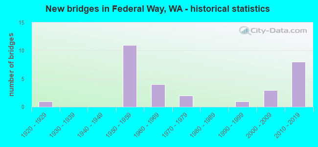
- New bridges - historical statistics
- 11920-1929
- 111950-1959
- 41960-1969
- 21970-1979
- 11990-1999
- 32000-2009
- 82010-2019

- Reconstructed bridges - Historical Statistics
- 41990-1999
- 32000-2009


- Bridge Condition - Deck
- 6.3%Very good
- 62.5%Good
- 31.3%Satisfactory

- Bridge Condition - Superstructure
- 17.6%Very good
- 23.5%Good
- 41.2%Satisfactory
- 17.6%Fair

- Bridge Condition - Substructure
- 17.6%Very good
- 76.5%Good
- 5.9%Satisfactory

- Bridge Condition - Culverts
- 50.0%Very good
- 50.0%Good
Find on map >> Show street view
Structure Number: HY, Location: 2.7 N PIERCE CO (Lat: 47.326667, Lng: -122.376969), Route carried "on" structure: State highway 509, Year Built: 1929, Year Reconstructed: 1996, Status: Open, Structure Length: 8.05m (26.41ft), Average Daily Traffic: 3,971 (year 2019), Truck Traffic: 5%, Average Future Daily Traffic: 5,607 (year 2039), Design Load: HS 20+Mod, Features Intersected: JOES CREEK
Minimum Vertical Clearance: 30+ m (98+ ft), Kilometerpoint: 15.981, Lanes on structure: 2, Owner: State Highway Agency, Approaching Roadway Width: 9.8m (32.2ft), Material/Design: Steel continuous, Design/Construction: Girder and Floorbeam System, Number Of Spans In Main Unit: 5, Length of Maximum Span: 21.9m (71.9ft), Curb or Sidewalk Widths: Left: 0.0m, Right: 1.8m (5.9ft), Curb-To-Curb Width: 8.5m (27.9ft), Out-to-Out Width: 11.0m (36.1ft)
Condition: Deck: Good, Superstructure: Satisfactory, Substructure: Satisfactory, Channel: Very good, Operating Rating: 49.0 metric tons, Method Used To Determine Operating Rating: Load Factor (LF), Inventory Rating: 29.9 metric tons, Method Used To Determine Inventory Rating: Load Factor (LF), Structural Evaluation: Equal to present minimum criteria, Deck Geometry: Meets minimum limits, Waterway Adequacy: Equal to present desirable criteria, Approach Roadway Alignment: Equal to present desirable criteria, Length Of Structure Improvement: 8.05m (26.41ft), Designated Inspection Frequency: Every 24 months, Critical Feature Inspection Frequency: Every 24 months, Inspection Date: August 2020, Critical Feature Inspection Date: August 2020, Bridge Improvement Cost: $1,795,000, Roadway Improvement Cost: $359,000, Total Project Cost: $3,590,000 ( Estimate for 2014), Deck Structure Type: Concrete Cast-file-Place, Wearing Surface/Protective System: Wearing Surface: Monolithic Concrete, Deck Protection: Epoxy Coated Reinforcing
Find on map >> Show street view
Structure Number: 6078A, Location: 2.5 N PIERCE CO (Lat: 47.289361, Lng: -122.306444), Route carried "on" structure: Interstate 5, Year Built: 1959, Status: Open, Structure Length: 6.28m (20.60ft), Average Daily Traffic: 71,294 (year 2019), Truck Traffic: 8%, Average Future Daily Traffic: 100,667 (year 2039), Design Load: HS 20, Features Intersected: SR 18
Minimum Vertical Clearance: 30+ m (98+ ft), Kilometerpoint: 228.527, Lanes on structure: 6, Lanes under structure: 6, Base Highway Network: Yes, Owner: State Highway Agency, Approaching Roadway Width: 30.5m (100.1ft), Skew: 1 degrees, Material/Design: Prestressed concrete, Design/Construction: Stringer/Multi-beam, Number Of Spans In Main Unit: 4, Length of Maximum Span: 19.8m (65.0ft), Curb-To-Curb Width: 30.5m (100.1ft), Out-to-Out Width: 31.0m (101.7ft)
Condition: Deck: Satisfactory, Superstructure: Fair, Substructure: Good, Operating Rating: 73.5 metric tons, Method Used To Determine Operating Rating: Load Factor (LF), Inventory Rating: 44.4 metric tons, Method Used To Determine Inventory Rating: Load Factor (LF), Structural Evaluation: Somewhat better than minimum adequacy, Deck Geometry: Superior to present desirable criteria, Underclear: High priority of corrective action, Approach Roadway Alignment: Equal to present desirable criteria, Length Of Structure Improvement: 6.28m (20.60ft), Designated Inspection Frequency: Every 24 months, Inspection Date: July 2021, Bridge Improvement Cost: $4,990,000, Roadway Improvement Cost: $998,000, Total Project Cost: $9,981,000 ( Estimate for 2022), Deck Structure Type: Concrete Cast-file-Place, Wearing Surface/Protective System: Wearing Surface: Epoxy Overlay, Deck Protection: Epoxy Coated Reinforcing
Find on map >> Show street view
Structure Number: 6078B, Location: 2.5 N PIERCE CO (Lat: 47.289361, Lng: -122.306972), Route carried "on" structure: Interstate 5, Year Built: 1959, Year Reconstructed: 2006, Status: Open, Structure Length: 6.49m (21.29ft), Average Daily Traffic: 71,294 (year 2019), Truck Traffic: 8%, Average Future Daily Traffic: 100,667 (year 2039), Design Load: HS 20, Features Intersected: SR 18
Minimum Vertical Clearance: 30+ m (98+ ft), Kilometerpoint: 228.527, Lanes on structure: 6, Lanes under structure: 6, Base Highway Network: Yes, Owner: State Highway Agency, Approaching Roadway Width: 30.5m (100.1ft), Skew: 1 degrees, Material/Design: Prestressed concrete, Design/Construction: Stringer/Multi-beam, Number Of Spans In Main Unit: 4, Length of Maximum Span: 19.8m (65.0ft), Curb-To-Curb Width: 30.5m (100.1ft), Out-to-Out Width: 31.0m (101.7ft)
Condition: Deck: Satisfactory, Superstructure: Satisfactory, Substructure: Good, Operating Rating: 73.5 metric tons, Method Used To Determine Operating Rating: Load Factor (LF), Inventory Rating: 44.4 metric tons, Method Used To Determine Inventory Rating: Load Factor (LF), Structural Evaluation: Equal to present minimum criteria, Deck Geometry: Superior to present desirable criteria, Underclear: High priority of corrective action, Approach Roadway Alignment: Equal to present desirable criteria, Length Of Structure Improvement: 6.49m (21.29ft), Designated Inspection Frequency: Every 24 months, Inspection Date: July 2021, Bridge Improvement Cost: $4,345,000, Roadway Improvement Cost: $869,000, Total Project Cost: $8,690,000 ( Estimate for 2014), Deck Structure Type: Concrete Cast-file-Place, Wearing Surface/Protective System: Wearing Surface: Epoxy Overlay
Find on map >> Show street view
Structure Number: 6094A, Location: 0.7 N PIERCE CO (Lat: 47.265389, Lng: -122.322694), Route carried "on" structure: County highway , Year Built: 1959, Status: Open, Structure Length: 9.17m (30.09ft), Average Daily Traffic: 516 (year 2002), Truck Traffic: 1%, Average Future Daily Traffic: 902 (year 2036), Design Load: HS 20, Features Intersected: I-5, Facility Carried by Structure: S 375TH ST
Minimum Vertical Clearance: 30+ m (98+ ft), Kilometerpoint: 0.805, Lanes on structure: 2, Lanes under structure: 10, Owner: State Highway Agency, Approaching Roadway Width: 8.5m (27.9ft), Material/Design: Prestressed concrete, Design/Construction: Stringer/Multi-beam, Number Of Spans In Main Unit: 5, Length of Maximum Span: 21.3m (69.9ft), Curb or Sidewalk Widths: Left: 0.6m (2.0ft), Right: 0.6m (2.0ft), Curb-To-Curb Width: 7.9m (25.9ft), Out-to-Out Width: 10.4m (34.1ft)
Condition: Deck: Good, Superstructure: Satisfactory, Substructure: Good, Operating Rating: 56.2 metric tons, Method Used To Determine Operating Rating: Load Factor (LF), Inventory Rating: 33.6 metric tons, Method Used To Determine Inventory Rating: Load Factor (LF), Structural Evaluation: Equal to present minimum criteria, Deck Geometry: Somewhat better than minimum adequacy, Underclear: Meets minimum limits, Approach Roadway Alignment: Equal to present desirable criteria, Length Of Structure Improvement: 9.17m (30.09ft), Designated Inspection Frequency: Every 24 months, Inspection Date: March 2020, Bridge Improvement Cost: $1,806,000, Roadway Improvement Cost: $361,000, Total Project Cost: $3,612,000 ( Estimate for 2014), Deck Structure Type: Concrete Cast-file-Place, Wearing Surface/Protective System: Wearing Surface: Monolithic Concrete
Find on map >> Show street view
Structure Number: 6094B, Location: 0.8 N JCT SR 18 (Lat: 47.300336, Lng: -122.302786), Route carried "on" structure: Interstate 5, Year Built: 1959, Year Reconstructed: 2006, Status: Open, Structure Length: 6.04m (19.82ft), Average Daily Traffic: 93,968 (year 2019), Truck Traffic: 8%, Average Future Daily Traffic: 132,682 (year 2039), Design Load: HS 20, Features Intersected: S 336TH ST
Minimum Vertical Clearance: 30+ m (98+ ft), Kilometerpoint: 229.798, Lanes on structure: 5, Lanes under structure: 2, Base Highway Network: Yes, Owner: State Highway Agency, Approaching Roadway Width: 24.4m (80.1ft), Skew: 1 degrees, Material/Design: Concrete continuous, Design/Construction: Box Beam or Girders - Multiple, Number Of Spans In Main Unit: 3, Length of Maximum Span: 23.8m (78.1ft), Curb-To-Curb Width: 24.4m (80.1ft), Out-to-Out Width: 25.3m (83.0ft)
Condition: Deck: Good, Superstructure: Satisfactory, Substructure: Good, Operating Rating: 49.9 metric tons, Method Used To Determine Operating Rating: Load Factor (LF), Inventory Rating: 29.9 metric tons, Method Used To Determine Inventory Rating: Load Factor (LF), Structural Evaluation: Equal to present minimum criteria, Deck Geometry: Equal to present minimum criteria, Underclear: Superior to present desirable criteria, Approach Roadway Alignment: Equal to present desirable criteria, Length Of Structure Improvement: 6.04m (19.82ft), Designated Inspection Frequency: Every 24 months, Inspection Date: May 2021, Bridge Improvement Cost: $3,247,000, Roadway Improvement Cost: $649,000, Total Project Cost: $6,494,000 ( Estimate for 2014), Deck Structure Type: Concrete Cast-file-Place, Wearing Surface/Protective System: Wearing Surface: Epoxy Overlay, Deck Protection: Epoxy Coated Reinforcing
Find on map >> Show street view
Structure Number: 6094C, Location: 0.8 N JCT SR 18 (Lat: 47.300400, Lng: -122.303208), Route carried "on" structure: Interstate 5, Year Built: 1959, Year Reconstructed: 2006, Status: Open, Structure Length: 4.75m (15.58ft), Average Daily Traffic: 93,968 (year 2019), Truck Traffic: 8%, Average Future Daily Traffic: 132,682 (year 2039), Design Load: HS 20, Features Intersected: S 336TH ST
Minimum Vertical Clearance: 30+ m (98+ ft), Kilometerpoint: 229.798, Lanes on structure: 5, Lanes under structure: 2, Base Highway Network: Yes, Owner: State Highway Agency, Approaching Roadway Width: 24.4m (80.1ft), Skew: 1 degrees, Material/Design: Concrete continuous, Design/Construction: Slab, Number Of Spans In Main Unit: 3, Length of Maximum Span: 18.6m (61.0ft), Curb-To-Curb Width: 24.4m (80.1ft), Out-to-Out Width: 25.3m (83.0ft)
Condition: Deck: Satisfactory, Superstructure: Satisfactory, Substructure: Good, Operating Rating: 50.5 metric tons, Method Used To Determine Operating Rating: Load and Resistance Factor Rating (LRFR) rating reported by rating factor(RF) method using HL-93 loadings, Inventory Rating: 39.2 metric tons, Method Used To Determine Inventory Rating: Load and Resistance Factor Rating (LRFR) rating reported by rating factor(RF) method using HL-93 loadings, Structural Evaluation: Equal to present minimum criteria, Deck Geometry: Equal to present minimum criteria, Underclear: Superior to present desirable criteria, Approach Roadway Alignment: Equal to present desirable criteria, Length Of Structure Improvement: 4.75m (15.58ft), Designated Inspection Frequency: Every 24 months, Inspection Date: May 2021, Bridge Improvement Cost: $2,558,000, Roadway Improvement Cost: $512,000, Total Project Cost: $5,117,000 ( Estimate for 2014), Deck Structure Type: Concrete Cast-file-Place, Wearing Surface/Protective System: Wearing Surface: Latex Concrete
Find on map >> Show street view
Structure Number: 6094D, Location: 5.6 N JCT SR 161/SR 167 (Lat: 47.278639, Lng: -122.310333), Route carried "on" structure: State highway 161, Year Built: 1959, Year Reconstructed: 1998, Status: Open, Structure Length: 12.37m (40.58ft), Average Daily Traffic: 30,808 (year 2019), Truck Traffic: 4%, Average Future Daily Traffic: 43,500 (year 2039), Design Load: HS 20, Features Intersected: I-5
Minimum Vertical Clearance: 30+ m (98+ ft), Kilometerpoint: 57.067, Lanes on structure: 5, Lanes under structure: 10, Base Highway Network: Yes, Owner: State Highway Agency, Approaching Roadway Width: 18.9m (62.0ft), Skew: 4 degrees, Material/Design: Prestressed concrete, Design/Construction: Stringer/Multi-beam, Number Of Spans In Main Unit: 5, Length of Maximum Span: 27.7m (90.9ft), Curb or Sidewalk Widths: Left: 2.0m (6.6ft), Right: 2.0m (6.6ft), Curb-To-Curb Width: 18.9m (62.0ft), Out-to-Out Width: 23.8m (78.1ft)
Condition: Deck: Good, Superstructure: Fair, Substructure: Good, Operating Rating: 58.0 metric tons, Method Used To Determine Operating Rating: Load Factor (LF), Inventory Rating: 33.6 metric tons, Method Used To Determine Inventory Rating: Load Factor (LF), Structural Evaluation: Somewhat better than minimum adequacy, Deck Geometry: Meets minimum limits, Underclear: High priority of corrective action, Approach Roadway Alignment: Equal to present desirable criteria, Length Of Structure Improvement: 12.37m (40.58ft), Designated Inspection Frequency: Every 24 months, Inspection Date: October 2020, Bridge Improvement Cost: $5,197,000, Roadway Improvement Cost: $1,039,000, Total Project Cost: $10,394,000 ( Estimate for 2014), Deck Structure Type: Concrete Cast-file-Place, Wearing Surface/Protective System: Wearing Surface: Latex Concrete, Deck Protection: Epoxy Coated Reinforcing
Find on map >> Show street view
Structure Number: 6124B, Location: 2.6 N JCT SR 18 (Lat: 47.327006, Lng: -122.294372), Route carried "on" structure: Interstate 5, Year Built: 1959, Year Reconstructed: 2002, Status: Open, Structure Length: 6.07m (19.91ft), Average Daily Traffic: 99,799 (year 2019), Truck Traffic: 8%, Average Future Daily Traffic: 140,916 (year 2039), Design Load: HS 20, Features Intersected: MILITARY RD
Minimum Vertical Clearance: 30+ m (98+ ft), Kilometerpoint: 232.792, Lanes on structure: 5, Lanes under structure: 2, Base Highway Network: Yes, Owner: State Highway Agency, Approaching Roadway Width: 23.8m (78.1ft), Skew: 4 degrees, Material/Design: Concrete continuous, Design/Construction: Box Beam or Girders - Multiple, Number Of Spans In Main Unit: 3, Length of Maximum Span: 23.8m (78.1ft), Curb-To-Curb Width: 24.0m (78.7ft), Out-to-Out Width: 24.5m (80.4ft)
Condition: Deck: Good, Superstructure: Good, Substructure: Good, Operating Rating: 70.7 metric tons, Method Used To Determine Operating Rating: Load Factor (LF), Inventory Rating: 42.6 metric tons, Method Used To Determine Inventory Rating: Load Factor (LF), Structural Evaluation: Better than present minimum criteria, Deck Geometry: Equal to present minimum criteria, Underclear: Somewhat better than minimum adequacy, Approach Roadway Alignment: Equal to present desirable criteria, Length Of Structure Improvement: 6.07m (19.91ft), Designated Inspection Frequency: Every 24 months, Inspection Date: January 2022, Bridge Improvement Cost: $3,781,000, Roadway Improvement Cost: $756,000, Total Project Cost: $7,562,000 ( Estimate for 2022), Deck Structure Type: Concrete Cast-file-Place, Wearing Surface/Protective System: Wearing Surface: Latex Concrete
Find on map >> Show street view
Structure Number: 6262A, Location: 1.8 N JCT SR 18 (Lat: 47.315139, Lng: -122.298194), Route carried "on" structure: County highway , Year Built: 1960, Status: Open, Structure Length: 10.12m (33.20ft), Average Daily Traffic: 49,879 (year 2021), Truck Traffic: 6%, Average Future Daily Traffic: 70,429 (year 2041), Design Load: HS 20, Features Intersected: I-5, Facility Carried by Structure: S 320TH ST
Minimum Vertical Clearance: 30+ m (98+ ft), Kilometerpoint: 0.129, Lanes on structure: 5, Lanes under structure: 14, Base Highway Network: Yes, Owner: State Highway Agency, Approaching Roadway Width: 24.4m (80.1ft), Skew: 1 degrees, Material/Design: Prestressed concrete, Design/Construction: Stringer/Multi-beam, Number Of Spans In Main Unit: 4, Length of Maximum Span: 30.5m (100.1ft), Curb-To-Curb Width: 22.3m (73.2ft), Out-to-Out Width: 23.2m (76.1ft)
Condition: Deck: Good, Superstructure: Satisfactory, Substructure: Good, Operating Rating: 58.0 metric tons, Method Used To Determine Operating Rating: Load Factor (LF), Inventory Rating: 33.6 metric tons, Method Used To Determine Inventory Rating: Load Factor (LF), Structural Evaluation: Equal to present minimum criteria, Deck Geometry: Equal to present minimum criteria, Underclear: High priority of corrective action, Approach Roadway Alignment: Equal to present desirable criteria, Length Of Structure Improvement: 10.12m (33.20ft), Designated Inspection Frequency: Every 24 months, Inspection Date: October 2020, Bridge Improvement Cost: $5,445,000, Roadway Improvement Cost: $1,089,000, Total Project Cost: $10,890,000 ( Estimate for 2014), Deck Structure Type: Concrete Cast-file-Place, Wearing Surface/Protective System: Wearing Surface: Integral Concrete
Find on map >> Show street view
Structure Number: 6313B, Location: 3.8 N JCT SR 18 (Lat: 47.343111, Lng: -122.293028), Route carried "on" structure: Interstate 5, Year Built: 1961, Year Reconstructed: 2002, Status: Open, Structure Length: 4.79m (15.72ft), Average Daily Traffic: 99,799 (year 2019), Truck Traffic: 8%, Average Future Daily Traffic: 140,916 (year 2039), Design Load: HS 20, Features Intersected: S 288TH ST
Minimum Vertical Clearance: 30+ m (98+ ft), Kilometerpoint: 234.626, Lanes on structure: 5, Lanes under structure: 4, Base Highway Network: Yes, Owner: State Highway Agency, Approaching Roadway Width: 23.8m (78.1ft), Material/Design: Prestressed concrete, Design/Construction: Stringer/Multi-beam, Number Of Spans In Main Unit: 3, Length of Maximum Span: 15.8m (51.8ft), Curb-To-Curb Width: 24.0m (78.7ft), Out-to-Out Width: 24.5m (80.4ft)
Condition: Deck: Good, Superstructure: Fair, Substructure: Good, Operating Rating: 56.2 metric tons, Method Used To Determine Operating Rating: Load Factor (LF), Inventory Rating: 33.6 metric tons, Method Used To Determine Inventory Rating: Load Factor (LF), Structural Evaluation: Somewhat better than minimum adequacy, Deck Geometry: Equal to present minimum criteria, Underclear: High priority of corrective action, Approach Roadway Alignment: Equal to present desirable criteria, Length Of Structure Improvement: 4.79m (15.72ft), Designated Inspection Frequency: Every 48 months, Inspection Date: June 2018, Bridge Improvement Cost: $2,512,000, Roadway Improvement Cost: $502,000, Total Project Cost: $5,024,000 ( Estimate for 2014), Deck Structure Type: Concrete Cast-file-Place, Wearing Surface/Protective System: Wearing Surface: Latex Concrete
Find on map >> Show street view
Structure Number: 6621A, Location: 5.0 N PIERCE CO (Lat: 47.330889, Lng: -122.334778), Route carried "on" structure: State highway 509, Year Built: 1961, Status: Open, Structure Length: 2.53m (8.30ft), Average Daily Traffic: 12,499 (year 2019), Truck Traffic: 3%, Average Future Daily Traffic: 17,648 (year 2039), Design Load: HS 15, Features Intersected: 1ST AVE S
Minimum Vertical Clearance: 30+ m (98+ ft), Kilometerpoint: 20.712, Lanes on structure: 2, Lanes under structure: 2, Owner: State Highway Agency, Approaching Roadway Width: 9.1m (29.9ft), Material/Design: Concrete continuous, Design/Construction: Slab, Number Of Spans In Main Unit: 3, Length of Maximum Span: 10.1m (33.1ft), Curb-To-Curb Width: 9.8m (32.2ft), Out-to-Out Width: 11.0m (36.1ft)
Condition: Deck: Good, Superstructure: Good, Substructure: Good, Operating Rating: 35.4 metric tons, Method Used To Determine Operating Rating: Load Factor (LF), Inventory Rating: 20.9 metric tons, Method Used To Determine Inventory Rating: Load Factor (LF), Structural Evaluation: Somewhat better than minimum adequacy, Deck Geometry: Meets minimum limits, Underclear: Meets minimum limits, Approach Roadway Alignment: High priority of corrective action, Length Of Structure Improvement: 2.53m (8.30ft), Designated Inspection Frequency: Every 24 months, Inspection Date: August 2021, Bridge Improvement Cost: $531,000, Roadway Improvement Cost: $106,000, Total Project Cost: $1,062,000 ( Estimate for 2014), Deck Structure Type: Concrete Cast-file-Place, Wearing Surface/Protective System: Wearing Surface: Bituminous, Membrane: Preformed Fabric
Find on map >> Show street view
Structure Number: 8834A, Location: 0.7 E JCT I-5 (Lat: 47.293694, Lng: -122.292333), Route carried "on" structure: County highway , Year Built: 1970, Status: Open, Structure Length: 9.45m (31.00ft), Average Daily Traffic: 12,865 (year 2016), Truck Traffic: 15%, Average Future Daily Traffic: 20,148 (year 2038), Design Load: HS 20+Mod, Features Intersected: SR 18, Facility Carried by Structure: WEYERHAEUSER WAY S
Minimum Vertical Clearance: 30+ m (98+ ft), Kilometerpoint: 0.097, Lanes on structure: 5, Lanes under structure: 6, Owner: State Highway Agency, Approaching Roadway Width: 22.9m (75.1ft), Skew: 3 degrees, Material/Design: Prestressed concrete continuous, Design/Construction: Stringer/Multi-beam, Number Of Spans In Main Unit: 4, Length of Maximum Span: 29.3m (96.1ft), Curb or Sidewalk Widths: Left: 0.2m (0.7ft), Right: 0.2m (0.7ft), Curb-To-Curb Width: 22.9m (75.1ft), Out-to-Out Width: 24.2m (79.4ft)
Condition: Deck: Good, Superstructure: Satisfactory, Substructure: Good, Operating Rating: 75.3 metric tons, Method Used To Determine Operating Rating: Load Factor (LF), Inventory Rating: 45.4 metric tons, Method Used To Determine Inventory Rating: Load Factor (LF), Structural Evaluation: Equal to present minimum criteria, Deck Geometry: Equal to present minimum criteria, Underclear: High priority of corrective action, Approach Roadway Alignment: Equal to present desirable criteria, Length Of Structure Improvement: 9.45m (31.00ft), Designated Inspection Frequency: Every 24 months, Inspection Date: March 2020, Bridge Improvement Cost: $4,774,000, Roadway Improvement Cost: $955,000, Total Project Cost: $9,548,000 ( Estimate for 2014), Deck Structure Type: Concrete Cast-file-Place, Wearing Surface/Protective System: Wearing Surface: Monolithic Concrete
Find on map >> Show street view
Structure Number: 16757A, Location: 2.0 N JCT SR 18 (Lat: 47.317800, Lng: -122.297175), Route carried "on" structure: City street 5, Year Built: 2006, Status: Open, Structure Length: 3.90m (12.80ft), Average Daily Traffic: 6,850 (year 2020), Truck Traffic: 5%, Average Future Daily Traffic: 10,585 (year 2040), Design Load: HL 93, Features Intersected: SB I-5, RAMP, Facility Carried by Structure: S 317TH ST
Minimum Vertical Clearance: 30+ m (98+ ft), Kilometerpoint: 0.161, Lanes on structure: 2, Lanes under structure: 7, Owner: State Highway Agency, Approaching Roadway Width: 18.6m (61.0ft), Material/Design: Prestressed concrete, Design/Construction: Box Beam or Girders - Single/Spread, Number Of Spans In Main Unit: 1, Length of Maximum Span: 37.5m (123.0ft), Curb-To-Curb Width: 13.8m (45.3ft), Out-to-Out Width: 14.8m (48.6ft)
Condition: Deck: Good, Superstructure: Good, Substructure: Good, Operating Rating: 68.0 metric tons, Method Used To Determine Operating Rating: Load Factor (LF), Inventory Rating: 40.8 metric tons, Method Used To Determine Inventory Rating: Load Factor (LF), Structural Evaluation: Better than present minimum criteria, Deck Geometry: Superior to present desirable criteria, Underclear: High priority of corrective action, Approach Roadway Alignment: Equal to present desirable criteria, Length Of Structure Improvement: 3.90m (12.80ft), Designated Inspection Frequency: Every 24 months, Inspection Date: January 2022, Bridge Improvement Cost: $1,613,000, Roadway Improvement Cost: $323,000, Total Project Cost: $3,226,000 ( Estimate for 2014), Deck Structure Type: Concrete Precast Panels, Wearing Surface/Protective System: Wearing Surface: Monolithic Concrete, Deck Protection: Epoxy Coated Reinforcing
Find on map >> Show street view
Structure Number: 17157A, Location: 0.9 N JCT SR 509 (Lat: 47.349572, Lng: -122.312439), Route carried "on" structure: State highway 99, Year Built: 2010, Status: Open, Structure Length: 8.14m (26.71ft), Average Daily Traffic: 40,204 (year 2019), Truck Traffic: 3%, Average Future Daily Traffic: 56,768 (year 2039), Design Load: HL 93, Features Intersected: DETENTION VAULT
Minimum Vertical Clearance: 30+ m (98+ ft), Kilometerpoint: 19.795, Lanes on structure: 1, Base Highway Network: Yes, Owner: State Highway Agency, Approaching Roadway Width: 9.8m (32.2ft), Skew: 10 degrees, Material/Design: Concrete, Design/Construction: Culvert, Number Of Spans In Main Unit: 1, Length of Maximum Span: 81.4m (267.1ft)
Condition: Culverts: Good, Operating Rating: 89.8 metric tons, Method Used To Determine Operating Rating: Load Factor (LF), Inventory Rating: 78.9 metric tons, Method Used To Determine Inventory Rating: Load Factor (LF), Structural Evaluation: Better than present minimum criteria, Approach Roadway Alignment: Equal to present desirable criteria, Length Of Structure Improvement: 8.14m (26.71ft), Designated Inspection Frequency: Every 24 months, Inspection Date: August 2021, Bridge Improvement Cost: $1,816,000, Roadway Improvement Cost: $363,000, Total Project Cost: $3,631,000 ( Estimate for 2014)
Find on map >> Show street view
Structure Number: 17936A, Location: JCT I-5 (Lat: 47.288111, Lng: -122.308083), Route carried "on" structure: Ramp State highway 18, Year Built: 2012, Status: Open, Structure Length: 44.17m (144.91ft), Average Daily Traffic: 15,685 (year 2019), Truck Traffic: 12%, Average Future Daily Traffic: 22,147 (year 2039), Design Load: HL 93, Features Intersected: 1-5 & SR 18
Minimum Vertical Clearance: 30+ m (98+ ft), Kilometerpoint: 0.241, Lanes on structure: 1, Lanes under structure: 17, Owner: State Highway Agency, Approaching Roadway Width: 8.2m (26.9ft), Material/Design: Steel continuous, Design/Construction: Box Beam or Girders - Single/Spread, Number Of Spans In Main Unit: 4, Number Of Approach Spans: 6, Length of Maximum Span: 56.7m (186.0ft), Curb-To-Curb Width: 8.2m (26.9ft), Out-to-Out Width: 8.8m (28.9ft)
Condition: Deck: Satisfactory, Superstructure: Very good, Substructure: Very good, Operating Rating: 43.7 metric tons, Method Used To Determine Operating Rating: Load and Resistance Factor Rating (LRFR) rating reported by rating factor(RF) method using HL-93 loadings, Inventory Rating: 33.7 metric tons, Method Used To Determine Inventory Rating: Load and Resistance Factor Rating (LRFR) rating reported by rating factor(RF) method using HL-93 loadings, Structural Evaluation: Equal to present desirable criteria, Deck Geometry: Superior to present desirable criteria, Underclear: Somewhat better than minimum adequacy, Approach Roadway Alignment: Equal to present desirable criteria, Length Of Structure Improvement: 44.17m (144.91ft), Designated Inspection Frequency: Every 24 months, Critical Feature Inspection Frequency: Every 24 months, Inspection Date: September 2020, Critical Feature Inspection Date: September 2020, Bridge Improvement Cost: $8,404,000, Roadway Improvement Cost: $1,681,000, Total Project Cost: $16,808,000 ( Estimate for 2014), Deck Structure Type: Concrete Cast-file-Place, Wearing Surface/Protective System: Wearing Surface: Monolithic Concrete, Deck Protection: Epoxy Coated Reinforcing
Find on map >> Show street view
Structure Number: 17936B, Location: JCT I-5 (Lat: 47.289833, Lng: -122.303361), Route carried "on" structure: Ramp State highway 18, Year Built: 2012, Status: Open, Structure Length: 73.37m (240.72ft), Average Daily Traffic: 29,116 (year 2019), Truck Traffic: 12%, Average Future Daily Traffic: 41,111 (year 2039), Design Load: HL 93, Features Intersected: I-5 & SR 18
Minimum Vertical Clearance: 30+ m (98+ ft), Kilometerpoint: 1.175, Lanes on structure: 2, Lanes under structure: 16, Owner: State Highway Agency, Approaching Roadway Width: 12.2m (40.0ft), Material/Design: Steel continuous, Design/Construction: Box Beam or Girders - Single/Spread, Number Of Spans In Main Unit: 5, Number Of Approach Spans: 9, Length of Maximum Span: 76.2m (250.0ft), Curb-To-Curb Width: 12.2m (40.0ft), Out-to-Out Width: 13.0m (42.7ft)
Condition: Deck: Satisfactory, Superstructure: Very good, Substructure: Very good, Operating Rating: 39.2 metric tons, Method Used To Determine Operating Rating: Load and Resistance Factor Rating (LRFR) rating reported by rating factor(RF) method using HL-93 loadings, Inventory Rating: 28.5 metric tons, Method Used To Determine Inventory Rating: Load and Resistance Factor Rating (LRFR) rating reported by rating factor(RF) method using HL-93 loadings, Structural Evaluation: Better than present minimum criteria, Deck Geometry: Superior to present desirable criteria, Underclear: Equal to present minimum criteria, Approach Roadway Alignment: Equal to present desirable criteria, Length Of Structure Improvement: 73.37m (240.72ft), Designated Inspection Frequency: Every 24 months, Critical Feature Inspection Frequency: Every 24 months, Inspection Date: September 2020, Critical Feature Inspection Date: September 2020, Bridge Improvement Cost: $20,219,000, Roadway Improvement Cost: $4,044,000, Total Project Cost: $40,438,000 ( Estimate for 2014), Deck Structure Type: Concrete Cast-file-Place, Wearing Surface/Protective System: Wearing Surface: Monolithic Concrete, Deck Protection: Epoxy Coated Reinforcing
Find on map >> Show street view
Structure Number: 18698A, Location: 3.2 N JCT I-5 (Lat: 47.272583, Lng: -122.329250), Route carried "on" structure: State highway 99, Year Built: 2015, Status: Open, Structure Length: 0.73m (2.40ft), Average Daily Traffic: 23,388 (year 2019), Truck Traffic: 10%, Average Future Daily Traffic: 33,023 (year 2039), Design Load: HL 93, Features Intersected: W. Fk. HYLEBOS CREEK
Minimum Vertical Clearance: 30+ m (98+ ft), Kilometerpoint: 10.976, Lanes on structure: 4, Base Highway Network: Yes, Owner: State Highway Agency, Approaching Roadway Width: 18.9m (62.0ft), Skew: 3 degrees, Material/Design: Concrete, Design/Construction: Culvert, Number Of Spans In Main Unit: 1, Length of Maximum Span: 7.0m (23.0ft)
Condition: Channel: Very good, Culverts: Very good, Operating Rating: 53.5 metric tons, Method Used To Determine Operating Rating: Load and Resistance Factor Rating (LRFR) rating reported by rating factor(RF) method using HL-93 loadings, Inventory Rating: 41.5 metric tons, Method Used To Determine Inventory Rating: Load and Resistance Factor Rating (LRFR) rating reported by rating factor(RF) method using HL-93 loadings, Structural Evaluation: Equal to present desirable criteria, Waterway Adequacy: Equal to present desirable criteria, Approach Roadway Alignment: Equal to present desirable criteria, Length Of Structure Improvement: 0.73m (2.40ft), Designated Inspection Frequency: Every 48 months, Inspection Date: November 2021, Bridge Improvement Cost: $307,000, Roadway Improvement Cost: $61,000, Total Project Cost: $614,000 ( Estimate for 2014), Wearing Surface/Protective System: Wearing Surface: Bituminous
Find on map >> Show street view
Structure Number: 86481, Location: DASH POINT STATE PARK (Lat: 47.318444, Lng: -122.413444), Route carried "on" structure: State lands road 82000, Year Built: 1993, Status: Open, Structure Length: 0.67m (2.20ft), Average Daily Traffic: 50 (year 2012), Average Future Daily Traffic: 63 (year 2036), Features Intersected: STREAM, Facility Carried by Structure: DAY USE ROAD
Minimum Vertical Clearance: 30+ m (98+ ft), Kilometerpoint: 0.001, Lanes on structure: 2, Owner: State Park, Forest, or Reservation Agency, Approaching Roadway Width: 9.4m (30.8ft), Material/Design: Concrete, Design/Construction: Arch - Deck, Number Of Spans In Main Unit: 1, Length of Maximum Span: 6.7m (22.0ft), Curb or Sidewalk Widths: Left: 0.0m, Right: 2.0m (6.6ft), Curb-To-Curb Width: 9.4m (30.8ft), Out-to-Out Width: 12.2m (40.0ft)
Condition: Superstructure: Good, Substructure: Good, Channel: Very good, Operating Rating: 54.4 metric tons, Method Used To Determine Operating Rating: Field evaluation and documented engineering judgment, Inventory Rating: 32.7 metric tons, Method Used To Determine Inventory Rating: Field evaluation and documented engineering judgment, Structural Evaluation: Better than present minimum criteria, Deck Geometry: Better than present minimum criteria, Waterway Adequacy: Equal to present desirable criteria, Approach Roadway Alignment: Equal to present desirable criteria, Length Of Structure Improvement: 0.67m (2.20ft), Designated Inspection Frequency: Every 24 months, Inspection Date: April 2021, Bridge Improvement Cost: $145,000, Roadway Improvement Cost: $29,000, Total Project Cost: $290,000 ( Estimate for 2014), Wearing Surface/Protective System: Wearing Surface: Bituminous
Find on map >> Show street view
Structure Number: 88227, Location: 0.25 MI E OF SR-99 (Lat: 47.267306, Lng: -122.329500), Route carried "on" structure: City street 20600, Year Built: 2006, Status: Open, Structure Length: 1.07m (3.51ft), Average Daily Traffic: 900 (year 2016), Truck Traffic: 4%, Average Future Daily Traffic: 1,050 (year 2037), Design Load: HS 25 or greater, Features Intersected: HYLEBOS CREEK, Facility Carried by Structure: S 373RD ST
Minimum Vertical Clearance: 30+ m (98+ ft), Kilometerpoint: 0.001, Lanes on structure: 2, Owner: City or Municipal Highway Agency, Approaching Roadway Width: 8.5m (27.9ft), Material/Design: Prestressed concrete, Design/Construction: Frame, Number Of Spans In Main Unit: 1, Length of Maximum Span: 10.1m (33.1ft), Curb-To-Curb Width: 8.5m (27.9ft), Out-to-Out Width: 9.8m (32.2ft)
Condition: Deck: Very good, Superstructure: Very good, Substructure: Very good, Channel: Very good, Operating Rating: 25.4 metric tons, Method Used To Determine Operating Rating: Field evaluation and documented engineering judgment, Inventory Rating: 15.4 metric tons, Method Used To Determine Inventory Rating: Field evaluation and documented engineering judgment, Structural Evaluation: Meets minimum limits, Deck Geometry: Somewhat better than minimum adequacy, Waterway Adequacy: Better than present minimum criteria, Approach Roadway Alignment: Equal to present desirable criteria, Length Of Structure Improvement: 1.07m (3.51ft), Designated Inspection Frequency: Every 24 months, Inspection Date: August 2020, Bridge Improvement Cost: $210,000, Roadway Improvement Cost: $42,000, Total Project Cost: $420,000 ( Estimate for 2014), Deck Structure Type: Concrete Precast Panels, Wearing Surface/Protective System: Wearing Surface: Bituminous
Find on map >> Show street view
Structure Number: 6078A, Location: 0.3 E JCT SR 161 (Lat: 47.289361, Lng: -122.306444), Route carried "under" structure: State highway 18, Year Built: 1959, Structure Length: 0. m, Average Daily Traffic: 70,119 (year 2019), Truck Traffic: 6%, Features Intersected: SR 18, Facility Carried by Structure: I-5
Minimum Vertical Clearance: 4.67m (15.32ft), Kilometerpoint: 0.016, Lanes on structure: 6, Lanes under structure: 6, Material/Design: Prestressed concrete, Design/Construction: Stringer/Multi-beam, Length of Maximum Span: 19.8m (65.0ft)
Find on map >> Show street view
Structure Number: 6078B, Location: 0.3 E JCT SR 161 (Lat: 47.289361, Lng: -122.306972), Route carried "under" structure: State highway 18, Year Built: 1959, Structure Length: 0. m, Average Daily Traffic: 70,119 (year 2019), Truck Traffic: 6%, Features Intersected: SR 18, Facility Carried by Structure: I-5
Minimum Vertical Clearance: 4.95m (16.24ft), Kilometerpoint: 4.377, Lanes on structure: 6, Lanes under structure: 6, Material/Design: Prestressed concrete, Design/Construction: Stringer/Multi-beam, Length of Maximum Span: 19.8m (65.0ft)
Find on map >> Show street view
Structure Number: 6094A, Location: 0.7 N PIERCE CO (Lat: 47.265389, Lng: -122.322694), Route carried "under" structure: Interstate 5, Year Built: 1959, Structure Length: 0. m, Average Daily Traffic: 195,413 (year 2019), Truck Traffic: 8%, Features Intersected: I-5
Minimum Vertical Clearance: 6.15m (20.18ft), Kilometerpoint: 225.550, Lanes on structure: 2, Lanes under structure: 10, Material/Design: Prestressed concrete, Design/Construction: Stringer/Multi-beam, Length of Maximum Span: 21.3m (69.9ft)
Find on map >> Show street view
Structure Number: 6094D, Location: 1.8 N PIERCE CO (Lat: 47.278639, Lng: -122.310333), Route carried "under" structure: Interstate 5, Year Built: 1959, Structure Length: 0. m, Average Daily Traffic: 195,413 (year 2019), Truck Traffic: 8%, Features Intersected: I-5, Facility Carried by Structure: SR 161
Minimum Vertical Clearance: 5.31m (17.42ft), Kilometerpoint: 227.320, Lanes on structure: 5, Lanes under structure: 10, Material/Design: Prestressed concrete, Design/Construction: Stringer/Multi-beam, Length of Maximum Span: 27.7m (90.9ft)
Find on map >> Show street view
Structure Number: 6262A, Location: 1.8 N JCT SR 18 (Lat: 47.315139, Lng: -122.298194), Route carried "under" structure: Interstate 5, Year Built: 1960, Structure Length: 0. m, Average Daily Traffic: 167,286 (year 2019), Truck Traffic: 8%, Features Intersected: I-5, Facility Carried by Structure: S 320TH ST
Minimum Vertical Clearance: 5.28m (17.32ft), Kilometerpoint: 231.472, Lanes on structure: 5, Lanes under structure: 14, Material/Design: Prestressed concrete, Design/Construction: Stringer/Multi-beam, Length of Maximum Span: 30.5m (100.1ft)
Find on map >> Show street view
Structure Number: 8834A, Location: 0.7 E JCT I-5 (Lat: 47.293694, Lng: -122.292333), Route carried "under" structure: State highway 18, Year Built: 1970, Structure Length: 0. m, Average Daily Traffic: 58,625 (year 2019), Truck Traffic: 9%, Features Intersected: SR 18, Facility Carried by Structure: WEYERHAEUSER WAY S
Minimum Vertical Clearance: 5.00m (16.40ft), Kilometerpoint: 1.239, Lanes on structure: 5, Lanes under structure: 6, Material/Design: Prestressed concrete continuous, Design/Construction: Stringer/Multi-beam, Length of Maximum Span: 29.3m (96.1ft)
Find on map >> Show street view
Structure Number: 16757A, Location: 2.0 N JCT SR 18 (Lat: 47.317800, Lng: -122.297175), Route carried "under" structure: Interstate 5, Year Built: 2006, Structure Length: 0. m, Average Daily Traffic: 83,643 (year 2019), Truck Traffic: 8%, Features Intersected: SB I-5, RAMP, Facility Carried by Structure: S 317TH ST
Minimum Vertical Clearance: 5.72m (18.77ft), Kilometerpoint: 231.778, Lanes on structure: 2, Lanes under structure: 5, Material/Design: Prestressed concrete, Design/Construction: Box Beam or Girders - Single/Spread, Length of Maximum Span: 37.5m (123.0ft)
Find on map >> Show street view
Structure Number: 17936A, Location: JCT SR 18 (Lat: 47.288111, Lng: -122.308083), Route carried "under" structure: Interstate 5, Year Built: 2012, Structure Length: 0. m, Average Daily Traffic: 142,588 (year 2019), Truck Traffic: 8%, Features Intersected: 1-5 & SR 18, Facility Carried by Structure: SR 18 E-N RAMP
Minimum Vertical Clearance: 6.71m (22.01ft), Kilometerpoint: 228.398, Lanes on structure: 1, Lanes under structure: 10, Material/Design: Steel continuous, Design/Construction: Box Beam or Girders - Single/Spread, Length of Maximum Span: 56.7m (186.0ft)
Find on map >> Show street view
Structure Number: 17936A, Location: JCT I-5 (Lat: 47.288111, Lng: -122.308083), Route carried "under" structure: State highway 18, Year Built: 2012, Structure Length: 0. m, Average Daily Traffic: 70,119 (year 2019), Truck Traffic: 6%, Features Intersected: 1-5 & SR 18
Minimum Vertical Clearance: 11.58m (37.99ft), Kilometerpoint: 0.064, Lanes on structure: 1, Lanes under structure: 6, Material/Design: Steel continuous, Design/Construction: Box Beam or Girders - Single/Spread, Length of Maximum Span: 56.7m (186.0ft)
Find on map >> Show street view
Structure Number: 17936B, Location: JCT I-5 (Lat: 47.289833, Lng: -122.303361), Route carried "under" structure: State highway 18, Year Built: 2012, Structure Length: 0. m, Average Daily Traffic: 70,119 (year 2019), Truck Traffic: 6%, Features Intersected: I-5 & SR 18
Minimum Vertical Clearance: 7.80m (25.59ft), Kilometerpoint: 0.177, Lanes on structure: 2, Lanes under structure: 4, Material/Design: Steel continuous, Design/Construction: Box Beam or Girders - Single/Spread, Length of Maximum Span: 76.2m (250.0ft)
Find on map >> Show street view
Structure Number: 17936B, Location: JCT SR 18 (Lat: 47.289833, Lng: -122.303361), Route carried "under" structure: Interstate 5, Year Built: 2012, Structure Length: 0. m, Average Daily Traffic: 142,588 (year 2019), Truck Traffic: 8%, Features Intersected: I-5 & SR 18, Facility Carried by Structure: SR 18 W-S RAMP
Minimum Vertical Clearance: 7.90m (25.92ft), Kilometerpoint: 228.366, Lanes on structure: 2, Lanes under structure: 10, Material/Design: Steel continuous, Design/Construction: Box Beam or Girders - Single/Spread, Length of Maximum Span: 76.2m (250.0ft)