Bridge Statistics for Fayetteville, West Virginia (WV)
Condition, Traffic, Stress, Structural Evaluation, Project Costs
- National Bridge Inventory (NBI) Statistics
- 19Number of bridges
- 522ft / 159mTotal length
- $1,845,000Total costs
- 27,504Total average daily traffic
- 3,019Total average daily truck traffic
- National Bridge Inventory (NBI) Registered Bridges for Fayetteville
- No street view available for this location
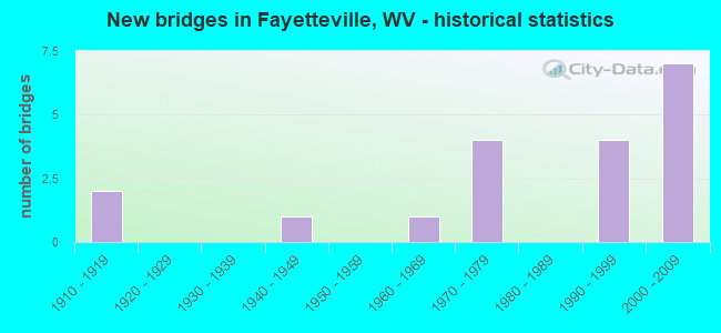
- New bridges - historical statistics
- 21910-1919
- 11940-1949
- 11960-1969
- 41970-1979
- 41990-1999
- 72000-2009

- Reconstructed bridges - Historical Statistics
- 11970-1979
- 01980-1989
- 21990-1999


- Bridge Condition - Deck
- 7.1%Very good
- 35.7%Good
- 35.7%Satisfactory
- 21.4%Fair

- Bridge Condition - Superstructure
- 43.8%Good
- 31.3%Satisfactory
- 25.0%Fair

- Bridge Condition - Substructure
- 12.5%Very good
- 37.5%Good
- 25.0%Satisfactory
- 12.5%Fair
- 12.5%Poor

- Bridge Condition - Channel
- 31.3%Excellent
- 31.3%Very good
- 25.0%Good
- 6.3%Satisfactory
- 6.3%Fair
Find on map >> Show street view
Structure Number: 10A025, Location: 1.25 Miles E. of WV 16 (Lat: 38.043089, Lng: -81.087869), Route carried "on" structure: County highway 900, Year Built: 1996, Status: Open, Structure Length: 2.61m (8.56ft), Average Daily Traffic: 1,600 (year 2018), Truck Traffic: 6%, Average Future Daily Traffic: 1,952 (year 2038), Features Intersected: WOLF CREEK, Facility Carried by Structure: COUNTY ROUTE 9
Minimum Vertical Clearance: 30+ m (98+ ft), Kilometerpoint: 2.012, Lanes on structure: 2, Owner: State Highway Agency, Approaching Roadway Width: 7.3m (24.0ft), Skew: 3 degrees, Material/Design: Prestressed concrete, Design/Construction: Box Beam or Girders - Multiple, Number Of Spans In Main Unit: 1, Length of Maximum Span: 24.5m (80.4ft), Curb-To-Curb Width: 8.9m (29.2ft), Out-to-Out Width: 9.4m (30.8ft)
Condition: Deck: Good, Superstructure: Good, Substructure: Good, Channel: Good, Operating Rating: 88.9 metric tons, Method Used To Determine Operating Rating: Load Factor (LF), Inventory Rating: 60.8 metric tons, Method Used To Determine Inventory Rating: Load Factor (LF), Structural Evaluation: Better than present minimum criteria, Deck Geometry: Somewhat better than minimum adequacy, Waterway Adequacy: Equal to present desirable criteria, Approach Roadway Alignment: Equal to present desirable criteria, Designated Inspection Frequency: Every 48 months, Inspection Date: October 2019, Deck Structure Type: Other, Wearing Surface/Protective System: Wearing Surface: Bituminous, Membrane: Preformed Fabric, Deck Protection: Epoxy Coated Reinforcing
Find on map >> Show street view
Structure Number: 10A214, Location: 1.16 Miles N. of WV 16 (Lat: 38.069369, Lng: -81.081689), Route carried "on" structure: US 1900, Year Built: 1977, Status: Open, Structure Length: 92.55m (303.64ft), Average Daily Traffic: 19,500 (year 2018), Truck Traffic: 13%, Average Future Daily Traffic: 22,480 (year 2035), Design Load: HS 20, Features Intersected: NEW RIVER CSX RR, WV 82, Facility Carried by Structure: US 19
Minimum Vertical Clearance: 30+ m (98+ ft), Kilometerpoint: 24.736, Lanes on structure: 4, Lanes under structure: 2, Base Highway Network: Yes, Owner: State Highway Agency, Approaching Roadway Width: 39.0m (128.0ft), Skew: 30 degrees, Material/Design: Steel, Design/Construction: Arch - Deck, Number Of Spans In Main Unit: 1, Number Of Approach Spans: 9, Length of Maximum Span: 553.7m (1,816.6ft), Curb-To-Curb Width: 20.5m (67.3ft), Out-to-Out Width: 22.4m (73.5ft)
Condition: Deck: Satisfactory, Superstructure: Fair, Substructure: Fair, Channel: Excellent, Operating Rating: 54.4 metric tons, Method Used To Determine Operating Rating: Load Factor (LF), Inventory Rating: 32.7 metric tons, Method Used To Determine Inventory Rating: Load Factor (LF), Structural Evaluation: Somewhat better than minimum adequacy, Deck Geometry: Superior to present desirable criteria, Underclear: Equal to present minimum criteria, Waterway Adequacy: Superior to present desirable criteria, Approach Roadway Alignment: Equal to present desirable criteria, Length Of Structure Improvement: 92.57m (303.71ft), Designated Inspection Frequency: Every 24 months, Critical Feature Inspection Frequency: Every 12 months, Other Special Inspection Frequency: Every 12 months, Inspection Date: September 2021, Critical Feature Inspection Date: September 2021, Other Special Inspection Date: September 2021, Deck Structure Type: Concrete Cast-file-Place, Wearing Surface/Protective System: Wearing Surface: Latex Concrete
Find on map >> Show street view
Structure Number: 10A253, Location: 3.92 Miles E. of US 19 (Lat: 38.064819, Lng: -81.077081), Route carried "on" structure: County highway 8200, Year Built: 1997, Status: Posted for load, Structure Length: 12.83m (42.09ft), Average Daily Traffic: 609 (year 2019), Truck Traffic: 6%, Average Future Daily Traffic: 743 (year 2039), Design Load: HS 15, Features Intersected: NEW RIVER, Facility Carried by Structure: COUNTY ROUTE 82
Minimum Vertical Clearance: 4.93m (16.17ft), Kilometerpoint: 7.419, Lanes on structure: 1, Owner: State Highway Agency, Approaching Roadway Width: 4.6m (15.1ft), Material/Design: Steel, Design/Construction: Truss - Thru, Number Of Spans In Main Unit: 1, Number Of Approach Spans: 2, Length of Maximum Span: 84.9m (278.5ft), Curb or Sidewalk Widths: Left: 1.5m (4.9ft), Right: 1.5m (4.9ft), Curb-To-Curb Width: 4.4m (14.4ft), Out-to-Out Width: 5.2m (17.1ft)
Condition: Deck: Fair, Superstructure: Good, Substructure: Good, Channel: Very good, Operating Rating: 47.2 metric tons, Method Used To Determine Operating Rating: Load Factor (LF), Inventory Rating: 29.0 metric tons, Method Used To Determine Inventory Rating: Load Factor (LF), Structural Evaluation: Better than present minimum criteria, Deck Geometry: High priority of replacement, Waterway Adequacy: Superior to present desirable criteria, Approach Roadway Alignment: High priority of corrective action, Length Of Structure Improvement: 12.83m (42.09ft), Designated Inspection Frequency: Every 24 months, Critical Feature Inspection Frequency: Every 24 months, Inspection Date: July 2020, Critical Feature Inspection Date: July 2020, Bridge Improvement Cost: $605,000, Roadway Improvement Cost: $496,000, Total Project Cost: $1,306,000 ( Estimate for 2018), Deck Structure Type: Wood or Timber, Wearing Surface/Protective System: Deck Protection: Other
Find on map >> Show street view
Structure Number: 10A256, Location: 0.01 Miles E. of CR 8/4 (Lat: 38.098139, Lng: -81.154100), Route carried "on" structure: County highway 1300, Year Built: 1917, Year Reconstructed: 1998, Status: Open, Structure Length: 1.75m (5.74ft), Average Daily Traffic: 757 (year 2019), Truck Traffic: 6%, Average Future Daily Traffic: 924 (year 2039), Features Intersected: LAUREL CREEK, Facility Carried by Structure: COUNTY ROUTE 13
Minimum Vertical Clearance: 30+ m (98+ ft), Kilometerpoint: 11.796, Lanes on structure: 2, Owner: State Highway Agency, Approaching Roadway Width: 4.6m (15.1ft), Material/Design: Concrete continuous, Design/Construction: Arch - Deck, Number Of Spans In Main Unit: 2, Length of Maximum Span: 7.8m (25.6ft), Curb-To-Curb Width: 5.4m (17.7ft), Out-to-Out Width: 6.3m (20.7ft)
Condition: Superstructure: Fair, Substructure: Fair, Channel: Fair, Operating Rating: 71.7 metric tons, Method Used To Determine Operating Rating: Field evaluation and documented engineering judgment, Inventory Rating: 32.7 metric tons, Method Used To Determine Inventory Rating: Field evaluation and documented engineering judgment, Structural Evaluation: Somewhat better than minimum adequacy, Deck Geometry: High priority of replacement, Waterway Adequacy: Equal to present desirable criteria, Approach Roadway Alignment: Equal to present minimum criteria, Length Of Structure Improvement: 1.77m (5.81ft), Designated Inspection Frequency: Every 24 months, Inspection Date: October 2021, Bridge Improvement Cost: $146,000, Roadway Improvement Cost: $143,000, Total Project Cost: $340,000 ( Estimate for 2021)
Find on map >> Show street view
Structure Number: 10A257, Location: 0.15 Miles S. of CR 8/1 (Lat: 38.054469, Lng: -81.160161), Route carried "on" structure: County highway 800, Year Built: 1913, Year Reconstructed: 1998, Status: Open, Structure Length: 0.85m (2.79ft), Average Daily Traffic: 171 (year 2020), Truck Traffic: 6%, Average Future Daily Traffic: 209 (year 2040), Features Intersected: LAUREL CREEK, Facility Carried by Structure: COUNTY ROUTE 8
Minimum Vertical Clearance: 30+ m (98+ ft), Kilometerpoint: 9.801, Lanes on structure: 1, Owner: State Highway Agency, Approaching Roadway Width: 3.7m (12.1ft), Material/Design: Masonry, Design/Construction: Arch - Deck, Number Of Spans In Main Unit: 1, Length of Maximum Span: 7.3m (24.0ft), Curb-To-Curb Width: 4.8m (15.7ft), Out-to-Out Width: 5.5m (18.0ft)
Condition: Superstructure: Satisfactory, Substructure: Satisfactory, Channel: Good, Operating Rating: 53.5 metric tons, Method Used To Determine Operating Rating: Field evaluation and documented engineering judgment, Inventory Rating: 24.5 metric tons, Method Used To Determine Inventory Rating: Field evaluation and documented engineering judgment, Structural Evaluation: Equal to present minimum criteria, Deck Geometry: High priority of corrective action, Waterway Adequacy: Equal to present desirable criteria, Approach Roadway Alignment: Equal to present desirable criteria, Length Of Structure Improvement: 0.73m (2.40ft), Designated Inspection Frequency: Every 24 months, Inspection Date: July 2021, Bridge Improvement Cost: $62,000, Roadway Improvement Cost: $61,000, Total Project Cost: $146,000 ( Estimate for 2021), Wearing Surface/Protective System: Wearing Surface: Monolithic Concrete
Find on map >> Show street view
Structure Number: 10A26, Location: 1.42 Miles N. of CR 13 (Lat: 38.113881, Lng: -81.143639), Route carried "on" structure: State highway 1600, Year Built: 1999, Status: Open, Structure Length: 24.79m (81.33ft), Average Daily Traffic: 1,782 (year 2019), Truck Traffic: 6%, Average Future Daily Traffic: 2,174 (year 2039), Design Load: HS 25 or greater, Features Intersected: NEW RIVER AND CSX RR, Facility Carried by Structure: WV 16
Minimum Vertical Clearance: 30+ m (98+ ft), Kilometerpoint: 35.084, Lanes on structure: 2, Owner: State Highway Agency, Approaching Roadway Width: 7.3m (24.0ft), Material/Design: Steel continuous, Design/Construction: Stringer/Multi-beam, Number Of Spans In Main Unit: 1, Number Of Approach Spans: 4, Length of Maximum Span: 51.1m (167.7ft), Curb-To-Curb Width: 8.4m (27.6ft), Out-to-Out Width: 9.4m (30.8ft)
Condition: Deck: Satisfactory, Superstructure: Good, Substructure: Good, Channel: Excellent, Operating Rating: 80.7 metric tons, Method Used To Determine Operating Rating: Field evaluation and documented engineering judgment, Inventory Rating: 49.0 metric tons, Method Used To Determine Inventory Rating: Field evaluation and documented engineering judgment, Structural Evaluation: Better than present minimum criteria, Deck Geometry: Meets minimum limits, Underclear: Better than present minimum criteria, Waterway Adequacy: Superior to present desirable criteria, Approach Roadway Alignment: Somewhat better than minimum adequacy, Designated Inspection Frequency: Every 24 months, Underwater Inspection Frequency: Every 60 months, Inspection Date: July 2020, Underwater Inspection Date: August 2018, Deck Structure Type: Concrete Cast-file-Place, Wearing Surface/Protective System: Wearing Surface: Monolithic Concrete, Deck Protection: Epoxy Coated Reinforcing
Find on map >> Show street view
Structure Number: 10A262, Location: 0.69 Miles N. of CR 82 (Lat: 38.077311, Lng: -81.059211), Route carried "on" structure: County highway 501, Year Built: 1998, Status: Open, Structure Length: 1.06m (3.48ft), Average Daily Traffic: 20 (year 2021), Truck Traffic: 6%, Average Future Daily Traffic: 24 (year 2041), Design Load: HS 25 or greater, Features Intersected: MILL CREEK, Facility Carried by Structure: COUNTY ROUTE 5/1
Minimum Vertical Clearance: 30+ m (98+ ft), Kilometerpoint: 1.110, Lanes on structure: 1, Owner: State Highway Agency, Approaching Roadway Width: 3.7m (12.1ft), Material/Design: Wood or Timber, Design/Construction: Slab, Number Of Spans In Main Unit: 1, Length of Maximum Span: 9.6m (31.5ft), Curb-To-Curb Width: 4.4m (14.4ft), Out-to-Out Width: 4.9m (16.1ft)
Condition: Deck: Satisfactory, Superstructure: Satisfactory, Substructure: Poor, Channel: Excellent, Operating Rating: 83.4 metric tons, Method Used To Determine Operating Rating: Allowable Stress (AS), Inventory Rating: 60.8 metric tons, Method Used To Determine Inventory Rating: Allowable Stress (AS), Structural Evaluation: Meets minimum limits, Deck Geometry: Equal to present minimum criteria, Waterway Adequacy: Better than present minimum criteria, Approach Roadway Alignment: High priority of corrective action, Designated Inspection Frequency: Every 24 months, Other Special Inspection Frequency: Every 3 months, Inspection Date: June 2021, Other Special Inspection Date: December 2021, Deck Structure Type: Other, Wearing Surface/Protective System: Wearing Surface: Bituminous, Deck Protection: Other
Find on map >> Show street view
Structure Number: 10A269, Location: 0.16 Miles S. of WV 16 (Lat: 38.050231, Lng: -81.100089), Route carried "on" structure: County highway 1915, Year Built: 2001, Status: Open, Structure Length: 1.16m (3.81ft), Average Daily Traffic: 110 (year 2020), Truck Traffic: 6%, Average Future Daily Traffic: 134 (year 2040), Design Load: HS 25 or greater, Features Intersected: HOUSE BRANCH, Facility Carried by Structure: COUNTY ROUTE 19/15
Minimum Vertical Clearance: 30+ m (98+ ft), Kilometerpoint: 1.609, Lanes on structure: 1, Owner: State Highway Agency, Approaching Roadway Width: 3.7m (12.1ft), Material/Design: Steel, Design/Construction: Stringer/Multi-beam, Number Of Spans In Main Unit: 1, Length of Maximum Span: 10.4m (34.1ft), Curb-To-Curb Width: 4.4m (14.4ft), Out-to-Out Width: 4.9m (16.1ft)
Condition: Deck: Fair, Superstructure: Satisfactory, Substructure: Satisfactory, Channel: Excellent, Operating Rating: 59.0 metric tons, Method Used To Determine Operating Rating: Load Factor (LF), Inventory Rating: 35.4 metric tons, Method Used To Determine Inventory Rating: Load Factor (LF), Structural Evaluation: Equal to present minimum criteria, Deck Geometry: High priority of replacement, Waterway Adequacy: Superior to present desirable criteria, Approach Roadway Alignment: Better than present minimum criteria, Designated Inspection Frequency: Every 24 months, Inspection Date: July 2021, Deck Structure Type: Wood or Timber
Find on map >> Show street view
Structure Number: 10A275, Location: 0.18 Miles S. of CR 13/7 (Lat: 38.107069, Lng: -81.151269), Route carried "on" structure: County highway 1304, Year Built: 2001, Status: Open, Structure Length: 1.89m (6.20ft), Average Daily Traffic: 55 (year 2020), Truck Traffic: 6%, Average Future Daily Traffic: 67 (year 2040), Design Load: HS 20, Features Intersected: SALLYS BRANCH, Facility Carried by Structure: COUNTY ROUTE 13/4
Minimum Vertical Clearance: 30+ m (98+ ft), Kilometerpoint: 1.416, Lanes on structure: 1, Owner: State Highway Agency, Approaching Roadway Width: 3.7m (12.1ft), Skew: 6 degrees, Material/Design: Steel, Design/Construction: Stringer/Multi-beam, Number Of Spans In Main Unit: 1, Length of Maximum Span: 16.5m (54.1ft), Curb-To-Curb Width: 4.1m (13.5ft), Out-to-Out Width: 4.2m (13.8ft)
Condition: Deck: Satisfactory, Superstructure: Good, Substructure: Good, Channel: Very good, Operating Rating: 88.9 metric tons, Method Used To Determine Operating Rating: Load Factor (LF), Inventory Rating: 67.1 metric tons, Method Used To Determine Inventory Rating: Load Factor (LF), Structural Evaluation: Better than present minimum criteria, Deck Geometry: Somewhat better than minimum adequacy, Waterway Adequacy: Superior to present desirable criteria, Approach Roadway Alignment: Equal to present minimum criteria, Designated Inspection Frequency: Every 48 months, Inspection Date: September 2021, Deck Structure Type: Wood or Timber
Find on map >> Show street view
Structure Number: 10A276, Location: 0.60 Miles S. of WV 16 (Lat: 38.070600, Lng: -81.111339), Route carried "on" structure: County highway 2104, Year Built: 2001, Status: Open, Structure Length: 0.85m (2.79ft), Average Daily Traffic: 123 (year 2020), Truck Traffic: 6%, Average Future Daily Traffic: 150 (year 2040), Design Load: HS 20, Features Intersected: MARR BRANCH, Facility Carried by Structure: COUNTY ROUTE 21/4
Minimum Vertical Clearance: 30+ m (98+ ft), Kilometerpoint: 0.966, Lanes on structure: 2, Owner: State Highway Agency, Approaching Roadway Width: 3.7m (12.1ft), Material/Design: Steel, Design/Construction: Stringer/Multi-beam, Number Of Spans In Main Unit: 1, Length of Maximum Span: 7.3m (24.0ft), Curb-To-Curb Width: 5.1m (16.7ft), Out-to-Out Width: 5.5m (18.0ft)
Condition: Deck: Very good, Superstructure: Satisfactory, Substructure: Satisfactory, Channel: Very good, Operating Rating: 88.0 metric tons, Method Used To Determine Operating Rating: Load Factor (LF), Inventory Rating: 52.6 metric tons, Method Used To Determine Inventory Rating: Load Factor (LF), Structural Evaluation: Equal to present minimum criteria, Deck Geometry: High priority of replacement, Waterway Adequacy: Better than present minimum criteria, Approach Roadway Alignment: Equal to present desirable criteria, Designated Inspection Frequency: Every 24 months, Inspection Date: December 2021, Deck Structure Type: Wood or Timber, Wearing Surface/Protective System: Deck Protection: Other
Find on map >> Show street view
Structure Number: 10A277, Location: 2.63 Miles W. of CR 85/3 (Lat: 38.064300, Lng: -81.081589), Route carried "on" structure: County highway 8200, Year Built: 2001, Status: Open, Structure Length: 2.00m (6.56ft), Average Daily Traffic: 236 (year 2020), Truck Traffic: 6%, Average Future Daily Traffic: 288 (year 2040), Design Load: HS 25 or greater, Features Intersected: WOLF CREEK, Facility Carried by Structure: COUTY ROUTE 82
Minimum Vertical Clearance: 30+ m (98+ ft), Kilometerpoint: 6.936, Lanes on structure: 2, Owner: State Highway Agency, Approaching Roadway Width: 3.7m (12.1ft), Material/Design: Prestressed concrete, Design/Construction: Box Beam or Girders - Multiple, Number Of Spans In Main Unit: 1, Length of Maximum Span: 18.9m (62.0ft), Curb-To-Curb Width: 4.9m (16.1ft), Out-to-Out Width: 4.9m (16.1ft)
Condition: Deck: Good, Superstructure: Good, Substructure: Good, Channel: Excellent, Operating Rating: 88.9 metric tons, Method Used To Determine Operating Rating: Load Factor (LF), Inventory Rating: 58.0 metric tons, Method Used To Determine Inventory Rating: Load Factor (LF), Structural Evaluation: Better than present minimum criteria, Deck Geometry: High priority of replacement, Waterway Adequacy: Superior to present desirable criteria, Approach Roadway Alignment: Equal to present minimum criteria, Designated Inspection Frequency: Every 24 months, Inspection Date: July 2021, Deck Structure Type: Other, Wearing Surface/Protective System: Wearing Surface: Bituminous, Deck Protection: Epoxy Coated Reinforcing
Find on map >> Show street view
Structure Number: 10A287, Location: 0.02 Miles N. of CR 8/4 (Lat: 38.082089, Lng: -81.145950), Route carried "on" structure: County highway 800, Year Built: 2003, Status: Open, Structure Length: 2.27m (7.45ft), Average Daily Traffic: 550 (year 2016), Truck Traffic: 6%, Average Future Daily Traffic: 686 (year 2036), Design Load: HS 25 or greater, Features Intersected: LAUREL CREEK, Facility Carried by Structure: COUNTY ROUTE 8
Minimum Vertical Clearance: 30+ m (98+ ft), Kilometerpoint: 14.661, Lanes on structure: 2, Owner: State Highway Agency, Approaching Roadway Width: 5.5m (18.0ft), Material/Design: Prestressed concrete, Design/Construction: Box Beam or Girders - Multiple, Number Of Spans In Main Unit: 1, Length of Maximum Span: 21.3m (69.9ft), Curb-To-Curb Width: 6.8m (22.3ft), Out-to-Out Width: 7.3m (24.0ft)
Condition: Deck: Good, Superstructure: Good, Substructure: Very good, Channel: Very good, Operating Rating: 83.4 metric tons, Method Used To Determine Operating Rating: Load Factor (LF), Inventory Rating: 50.8 metric tons, Method Used To Determine Inventory Rating: Load Factor (LF), Structural Evaluation: Better than present minimum criteria, Deck Geometry: Meets minimum limits, Waterway Adequacy: Superior to present desirable criteria, Approach Roadway Alignment: Meets minimum limits, Designated Inspection Frequency: Every 48 months, Inspection Date: July 2019, Deck Structure Type: Other, Wearing Surface/Protective System: Wearing Surface: Bituminous, Deck Protection: Epoxy Coated Reinforcing
Find on map >> Show street view
Structure Number: 10A296, Location: 0.01 Miles N. of CR 5 (Lat: 38.083900, Lng: -81.068831), Route carried "on" structure: County highway 500, Year Built: 2007, Status: Open, Structure Length: 0.97m (3.18ft), Average Daily Traffic: 100 (year 2019), Truck Traffic: 6%, Average Future Daily Traffic: 122 (year 2039), Features Intersected: MILL CREEK, Facility Carried by Structure: COUNTY ROUTE 5
Minimum Vertical Clearance: 30+ m (98+ ft), Kilometerpoint: 2.462, Lanes on structure: 2, Owner: State Highway Agency, Approaching Roadway Width: 4.9m (16.1ft), Material/Design: Steel, Design/Construction: Stringer/Multi-beam, Number Of Spans In Main Unit: 1, Length of Maximum Span: 8.4m (27.6ft), Curb-To-Curb Width: 6.2m (20.3ft), Out-to-Out Width: 6.2m (20.3ft)
Condition: Deck: Fair, Superstructure: Fair, Substructure: Satisfactory, Channel: Good, Operating Rating: 88.9 metric tons, Method Used To Determine Operating Rating: Load Factor (LF), Inventory Rating: 81.6 metric tons, Method Used To Determine Inventory Rating: Load Factor (LF), Structural Evaluation: Somewhat better than minimum adequacy, Deck Geometry: Somewhat better than minimum adequacy, Waterway Adequacy: Superior to present desirable criteria, Approach Roadway Alignment: Meets minimum limits, Designated Inspection Frequency: Every 24 months, Inspection Date: November 2021, Deck Structure Type: Wood or Timber, Wearing Surface/Protective System: Deck Protection: Other
Find on map >> Show street view
Structure Number: 10A298, Location: 0.04 Miles N. of CR 60/9 (Lat: 38.091889, Lng: -81.057019), Route carried "on" structure: County highway 501, Year Built: 2009, Status: Open, Structure Length: 10.46m (34.32ft), Average Daily Traffic: 20 (year 2016), Average Future Daily Traffic: 25 (year 2036), Design Load: HS 20, Features Intersected: OPOSSUM CREEK, Facility Carried by Structure: COUNTY ROUTE 5/1
Minimum Vertical Clearance: 30+ m (98+ ft), Kilometerpoint: 3.605, Lanes on structure: 2, Owner: State Highway Agency, Approaching Roadway Width: 4.3m (14.1ft), Skew: 2 degrees, Material/Design: Steel, Design/Construction: Stringer/Multi-beam, Number Of Spans In Main Unit: 1, Length of Maximum Span: 10.1m (33.1ft), Curb-To-Curb Width: 7.1m (23.3ft), Out-to-Out Width: 7.6m (24.9ft)
Condition: Deck: Satisfactory, Superstructure: Good, Substructure: Very good, Channel: Very good, Operating Rating: 52.6 metric tons, Method Used To Determine Operating Rating: Load and Resistance Factor (LRFR), Inventory Rating: 40.8 metric tons, Method Used To Determine Inventory Rating: Load and Resistance Factor (LRFR), Structural Evaluation: Better than present minimum criteria, Deck Geometry: Somewhat better than minimum adequacy, Waterway Adequacy: Equal to present minimum criteria, Approach Roadway Alignment: Equal to present minimum criteria, Designated Inspection Frequency: Every 48 months, Inspection Date: July 2019, Deck Structure Type: Wood or Timber, Wearing Surface/Protective System: Deck Protection: Other
Find on map >> Show street view
Structure Number: 10A905, Location: 0.01 Miles E. of CR 8 (Lat: 38.074931, Lng: -81.153789), Route carried "on" structure: ServiceOther road N0535, Year Built: 1970, Status: Posted for load, Structure Length: 1.15m (3.77ft), Average Daily Traffic: 12 (year 2019), Average Future Daily Traffic: 15 (year 2039), Features Intersected: DEMPSEY BRANCH
Minimum Vertical Clearance: 30+ m (98+ ft), Kilometerpoint: 0.032, Lanes on structure: 1, Owner: Local Agency, Approaching Roadway Width: 3.7m (12.1ft), Material/Design: Steel, Design/Construction: Stringer/Multi-beam, Number Of Spans In Main Unit: 1, Length of Maximum Span: 11.5m (37.7ft), Curb-To-Curb Width: 3.5m (11.5ft), Out-to-Out Width: 3.7m (12.1ft)
Condition: Deck: Good, Superstructure: Satisfactory, Substructure: Poor, Channel: Satisfactory, Operating Rating: 2.7 metric tons, Method Used To Determine Operating Rating: Load Factor (LF), Inventory Rating: 2.7 metric tons, Method Used To Determine Inventory Rating: Load Factor (LF), Structural Evaluation: High priority of corrective action, Deck Geometry: High priority of corrective action, Waterway Adequacy: Superior to present desirable criteria, Approach Roadway Alignment: Equal to present minimum criteria, Bridge Posting: Required (Relationship of Operating Rating to Maximum Legal Load: > 39.9% below), Designated Inspection Frequency: Every 24 months, Other Special Inspection Frequency: Every 12 months, Inspection Date: January 2021, Other Special Inspection Date: January 2021, Deck Structure Type: Wood or Timber, Wearing Surface/Protective System: Deck Protection: Other
Find on map >> Show street view
Structure Number: 4780003P, Location: 0.01 MILES FROM WV ROUTE (Lat: 38.065639, Lng: -81.080222), Route carried "on" structure: Federal lands road , Year Built: 1960, Year Reconstructed: 1975, Status: Open, Structure Length: 1.62m (5.31ft), Average Daily Traffic: 250 (year 2019), Truck Traffic: 2%, Average Future Daily Traffic: 375 (year 2039), Features Intersected: WOLF CREEK, Facility Carried by Structure: FAYETTE STATION BR
Minimum Vertical Clearance: 30+ m (98+ ft), Kilometerpoint: 0.000, Lanes on structure: 1, Owner: National Park Service, Approaching Roadway Width: 4.0m (13.1ft), Material/Design: Steel, Design/Construction: Stringer/Multi-beam, Number Of Spans In Main Unit: 1, Length of Maximum Span: 15.6m (51.2ft), Curb-To-Curb Width: 4.0m (13.1ft), Out-to-Out Width: 5.5m (18.0ft)
Condition: Deck: Good, Superstructure: Fair, Substructure: Good, Channel: Good, Operating Rating: 29.0 metric tons, Method Used To Determine Operating Rating: Load Factor (LF), Inventory Rating: 17.2 metric tons, Method Used To Determine Inventory Rating: Load Factor (LF), Structural Evaluation: Somewhat better than minimum adequacy, Deck Geometry: High priority of replacement, Waterway Adequacy: Equal to present desirable criteria, Approach Roadway Alignment: Equal to present minimum criteria, Length Of Structure Improvement: 0.76m (2.49ft), Designated Inspection Frequency: Every 24 months, Inspection Date: November 2021, Bridge Improvement Cost: $36,000, Roadway Improvement Cost: $4,000, Total Project Cost: $53,000 ( Estimate for 2021), Deck Structure Type: Wood or Timber, Wearing Surface/Protective System: Wearing Surface: Wood or Timber
Find on map >> Show street view
Structure Number: 10A186, Location: 4.43 Miles N. of WV 16 (Lat: 38.065419, Lng: -81.080319), Route carried "under" structure: County highway 8200, Year Built: 1946, Structure Length: 0. m, Average Daily Traffic: 609 (year 2020), Truck Traffic: 6%, Features Intersected: CSX RAILROAD, Facility Carried by Structure: CSX RAILROAD
Minimum Vertical Clearance: 4.19m (13.75ft), Kilometerpoint: 7.129, Lanes under structure: 2, Material/Design: Steel, Design/Construction: Stringer/Multi-beam, Length of Maximum Span: 18.2m (59.7ft)
Find on map >> Show street view
Structure Number: 10A214, Location: 1.16 Miles N. of WV 16 (Lat: 38.069369, Lng: -81.081689), Route carried "under" structure: County highway 8200, Year Built: 1977, Structure Length: 0. m, Average Daily Traffic: 750 (year 0009), Truck Traffic: 8%, Features Intersected: NEW RIVER CSX RR, WV 82, Facility Carried by Structure: US 19
Minimum Vertical Clearance: 30+ m (98+ ft), Kilometerpoint: 4.699, Lanes on structure: 4, Lanes under structure: 1, Length of Maximum Span: 553.7m (1,816.6ft)
Find on map >> Show street view
Structure Number: 10A214, Location: 1.16 Miles N. of WV 16 (Lat: 38.069369, Lng: -81.081689), Route carried "under" structure: County highway 8200, Year Built: 1977, Structure Length: 0. m, Average Daily Traffic: 250 (year 0009), Truck Traffic: 8%, Features Intersected: NEW RIVER CSX RR, WV 82, Facility Carried by Structure: US 19
Minimum Vertical Clearance: 21.64m (71.00ft), Kilometerpoint: 10.429, Lanes on structure: 4, Lanes under structure: 1, Length of Maximum Span: 553.7m (1,816.6ft)