Bridge Statistics for Faxon, Pennsylvania (PA)
Condition, Traffic, Stress, Structural Evaluation, Project Costs
- National Bridge Inventory (NBI) Statistics
- 11Number of bridges
- 102ft / 31.0mTotal length
- 100,468Total average daily traffic
- 7,475Total average daily truck traffic
- National Bridge Inventory (NBI) Registered Bridges for Faxon
- No street view available for this location
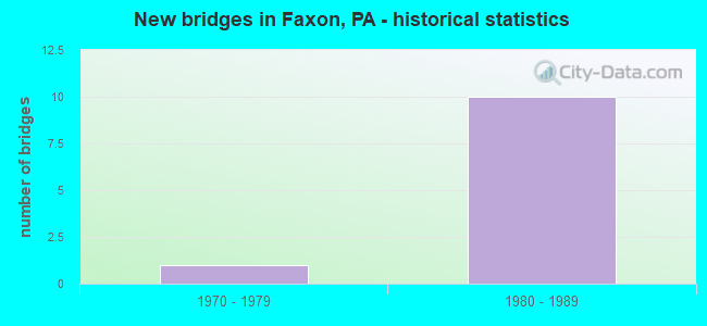
- New bridges - historical statistics
- 11970-1979
- 101980-1989


- Bridge Condition - Superstructure
- 60.0%Good
- 40.0%Satisfactory

- Bridge Condition - Substructure
- 20.0%Good
- 80.0%Satisfactory
Find on map >> Show street view
Structure Number: 24629, Location: .5MI E WLLMSPRT CITY LINE (Lat: 41.248644, Lng: -76.976031), Route carried "on" structure: Interstate 180, Year Built: 1982, Status: Open, Structure Length: 6.10m (20.01ft), Average Daily Traffic: 17,651 (year 2021), Truck Traffic: 10%, Average Future Daily Traffic: 29,934 (year 2032), Design Load: HS 20, Features Intersected: SR 2029 (FAXON)
Minimum Vertical Clearance: 30+ m (98+ ft), Kilometerpoint: 5.543, Lanes on structure: 3, Lanes under structure: 4, Base Highway Network: Yes, Owner: State Highway Agency, Approaching Roadway Width: 16.5m (54.1ft), Skew: 13 degrees, Material/Design: Prestressed concrete, Design/Construction: Stringer/Multi-beam, Number Of Spans In Main Unit: 3, Length of Maximum Span: 31.7m (104.0ft), Curb-To-Curb Width: 15.8m (51.8ft), Out-to-Out Width: 17.5m (57.4ft)
Condition: Deck: Good, Superstructure: Good, Substructure: Good, Operating Rating: 56.2 metric tons, Method Used To Determine Operating Rating: Load Factor (LF), Inventory Rating: 33.6 metric tons, Method Used To Determine Inventory Rating: Load Factor (LF), Structural Evaluation: Better than present minimum criteria, Deck Geometry: Somewhat better than minimum adequacy, Underclear: Equal to present minimum criteria, Approach Roadway Alignment: Equal to present desirable criteria, Length Of Structure Improvement: 7.10m (23.29ft), Designated Inspection Frequency: Every 24 months, Inspection Date: January 2020, Deck Structure Type: Concrete Cast-file-Place, Wearing Surface/Protective System: Wearing Surface: Latex Concrete, Deck Protection: Epoxy Coated Reinforcing
Find on map >> Show street view
Structure Number: 2463, Location: .5 M E WMSPT CITY LINE (Lat: 41.248261, Lng: -76.974708), Route carried "on" structure: Interstate 180, Year Built: 1982, Status: Open, Structure Length: 5.06m (16.60ft), Average Daily Traffic: 17,651 (year 2021), Truck Traffic: 10%, Average Future Daily Traffic: 29,934 (year 2032), Design Load: HS 20, Features Intersected: MILLER'S RUN & T480 ROAD
Minimum Vertical Clearance: 30+ m (98+ ft), Kilometerpoint: 5.543, Lanes on structure: 3, Lanes under structure: 2, Base Highway Network: Yes, Owner: State Highway Agency, Approaching Roadway Width: 18.9m (62.0ft), Skew: 10 degrees, Material/Design: Prestressed concrete, Design/Construction: Box Beam or Girders - Single/Spread, Number Of Spans In Main Unit: 2, Length of Maximum Span: 25.3m (83.0ft), Curb-To-Curb Width: 15.8m (51.8ft), Out-to-Out Width: 16.9m (55.4ft)
Condition: Deck: Good, Superstructure: Good, Substructure: Satisfactory, Channel: Good, Inventory Rating: 50.8 metric tons, Method Used To Determine Inventory Rating: Load Factor (LF), Structural Evaluation: Equal to present minimum criteria, Deck Geometry: Somewhat better than minimum adequacy, Underclear: Superior to present desirable criteria, Waterway Adequacy: Superior to present desirable criteria, Approach Roadway Alignment: Equal to present desirable criteria, Length Of Structure Improvement: 6.00m (19.69ft), Designated Inspection Frequency: Every 48 months, Inspection Date: January 2020, Deck Structure Type: Concrete Cast-file-Place, Wearing Surface/Protective System: Wearing Surface: Epoxy Overlay, Deck Protection: Epoxy Coated Reinforcing
Find on map >> Show street view
Structure Number: 24633, Location: .5MI E WLLMSPRT CITY LINE (Lat: 41.248775, Lng: -76.975789), Route carried "on" structure: Interstate 180, Year Built: 1982, Status: Open, Structure Length: 6.04m (19.82ft), Average Daily Traffic: 15,740 (year 2021), Truck Traffic: 11%, Average Future Daily Traffic: 29,669 (year 2032), Design Load: HS 20, Features Intersected: SR 2029
Minimum Vertical Clearance: 5.43m (17.81ft), Kilometerpoint: 5.531, Lanes on structure: 2, Lanes under structure: 4, Base Highway Network: Yes, Owner: State Highway Agency, Approaching Roadway Width: 11.6m (38.1ft), Skew: 13 degrees, Material/Design: Prestressed concrete, Design/Construction: Stringer/Multi-beam, Number Of Spans In Main Unit: 3, Length of Maximum Span: 31.4m (103.0ft), Curb or Sidewalk Widths: Left: 0.2m (0.7ft), Right: 0.2m (0.7ft), Curb-To-Curb Width: 12.8m (42.0ft), Out-to-Out Width: 13.7m (44.9ft)
Condition: Deck: Good, Superstructure: Good, Substructure: Satisfactory, Operating Rating: 55.3 metric tons, Method Used To Determine Operating Rating: Load Factor (LF), Inventory Rating: 32.7 metric tons, Method Used To Determine Inventory Rating: Load Factor (LF), Structural Evaluation: Equal to present minimum criteria, Deck Geometry: Equal to present desirable criteria, Underclear: Superior to present desirable criteria, Approach Roadway Alignment: Equal to present desirable criteria, Length Of Structure Improvement: 7.10m (23.29ft), Designated Inspection Frequency: Every 24 months, Inspection Date: January 2020, Deck Structure Type: Concrete Cast-file-Place, Wearing Surface/Protective System: Wearing Surface: Epoxy Overlay, Deck Protection: Epoxy Coated Reinforcing
Find on map >> Show street view
Structure Number: 24634, Location: .5 M E WLLMSPRT CTY LINE (Lat: 41.248414, Lng: -76.974586), Route carried "on" structure: Interstate 180, Year Built: 1982, Status: Open, Structure Length: 5.06m (16.60ft), Average Daily Traffic: 15,740 (year 2021), Truck Traffic: 11%, Average Future Daily Traffic: 29,669 (year 2032), Design Load: HS 20, Features Intersected: MILLER'S RUN & T480 ROAD
Minimum Vertical Clearance: 30+ m (98+ ft), Kilometerpoint: 5.531, Lanes on structure: 2, Lanes under structure: 2, Base Highway Network: Yes, Owner: State Highway Agency, Approaching Roadway Width: 12.8m (42.0ft), Skew: 10 degrees, Material/Design: Prestressed concrete, Design/Construction: Box Beam or Girders - Single/Spread, Number Of Spans In Main Unit: 2, Length of Maximum Span: 25.0m (82.0ft), Curb-To-Curb Width: 12.8m (42.0ft), Out-to-Out Width: 13.9m (45.6ft)
Condition: Deck: Good, Superstructure: Satisfactory, Substructure: Satisfactory, Channel: Good, Inventory Rating: 54.4 metric tons, Method Used To Determine Inventory Rating: Load Factor (LF), Structural Evaluation: Equal to present minimum criteria, Deck Geometry: Equal to present desirable criteria, Underclear: Superior to present desirable criteria, Waterway Adequacy: Superior to present desirable criteria, Approach Roadway Alignment: Equal to present desirable criteria, Length Of Structure Improvement: 6.00m (19.69ft), Designated Inspection Frequency: Every 48 months, Inspection Date: January 2020, Deck Structure Type: Concrete Cast-file-Place, Wearing Surface/Protective System: Wearing Surface: Epoxy Overlay, Deck Protection: Epoxy Coated Reinforcing
Find on map >> Show street view
Structure Number: 33002, Location: 1.5MI W OF LIBERTY (Lat: 41.549483, Lng: -77.123900), Route carried "on" structure: State highway , Year Built: 1975, Status: Open, Structure Length: 8.78m (28.81ft), Average Daily Traffic: 112 (year 2022), Truck Traffic: 9%, Average Future Daily Traffic: 205 (year 2032), Design Load: HS 20, Features Intersected: OVER SR15 NB & SB, Facility Carried by Structure: SR 2002
Minimum Vertical Clearance: 30+ m (98+ ft), Kilometerpoint: 0.715, Lanes on structure: 2, Lanes under structure: 4, Owner: State Highway Agency, Approaching Roadway Width: 6.7m (22.0ft), Material/Design: Prestressed concrete, Design/Construction: Stringer/Multi-beam, Number Of Spans In Main Unit: 4, Length of Maximum Span: 32.0m (105.0ft), Curb or Sidewalk Widths: Left: 0.2m (0.7ft), Right: 0.2m (0.7ft), Curb-To-Curb Width: 12.8m (42.0ft), Out-to-Out Width: 14.0m (45.9ft)
Condition: Deck: Good, Superstructure: Satisfactory, Substructure: Satisfactory, Operating Rating: 67.1 metric tons, Method Used To Determine Operating Rating: Load Factor (LF), Inventory Rating: 34.5 metric tons, Method Used To Determine Inventory Rating: Load Factor (LF), Structural Evaluation: Equal to present minimum criteria, Deck Geometry: Superior to present desirable criteria, Underclear: Superior to present desirable criteria, Approach Roadway Alignment: Equal to present desirable criteria, Length Of Structure Improvement: 9.80m (32.15ft), Designated Inspection Frequency: Every 24 months, Inspection Date: September 2021, Deck Structure Type: Concrete Cast-file-Place, Wearing Surface/Protective System: Wearing Surface: Epoxy Overlay
Find on map >> Show street view
Structure Number: 24629, Location: .5MI E WLLMSPRT CITY LINE (Lat: 41.248644, Lng: -76.976031), Route carried "under" structure: State highway , Year Built: 1982, Structure Length: 0. m, Average Daily Traffic: 6,966 (year 2022), Truck Traffic: 2%, Features Intersected: SR 2029 (FAXON), Facility Carried by Structure: I - 180 EB
Minimum Vertical Clearance: 4.57m (14.99ft), Kilometerpoint: 0.000, Lanes on structure: 3, Lanes under structure: 2, Material/Design: Prestressed concrete, Design/Construction: Stringer/Multi-beam, Length of Maximum Span: 31.7m (104.0ft)
Find on map >> Show street view
Structure Number: 24629, Location: .5MI E WLLMSPRT CITY LINE (Lat: 41.248644, Lng: -76.976031), Route carried "under" structure: State highway , Year Built: 1982, Structure Length: 0. m, Average Daily Traffic: 9,671 (year 2022), Truck Traffic: 1%, Features Intersected: SR 2029 (FAXON), Facility Carried by Structure: I - 180 EB
Minimum Vertical Clearance: 4.57m (14.99ft), Kilometerpoint: 0.000, Lanes on structure: 3, Lanes under structure: 2, Material/Design: Prestressed concrete, Design/Construction: Stringer/Multi-beam, Length of Maximum Span: 31.7m (104.0ft)
Find on map >> Show street view
Structure Number: 2463, Location: .5 M E WMSPT CITY LINE (Lat: 41.248261, Lng: -76.974708), Route carried "under" structure: City street T481, Year Built: 1982, Structure Length: 0. m, Average Daily Traffic: 100 (year 2004), Truck Traffic: 1%, Features Intersected: MILLER'S RUN & T480 ROAD, Facility Carried by Structure: I-180 EBL (RAMP D)
Minimum Vertical Clearance: 7.72m (25.33ft), Kilometerpoint: 0.000, Lanes on structure: 3, Lanes under structure: 2, Material/Design: Prestressed concrete, Design/Construction: Box Beam or Girders - Single/Spread, Length of Maximum Span: 25.3m (83.0ft)
Find on map >> Show street view
Structure Number: 24633, Location: .5MI E WLLMSPRT CITY LINE (Lat: 41.248775, Lng: -76.975789), Route carried "under" structure: State highway , Year Built: 1982, Structure Length: 0. m, Average Daily Traffic: 6,966 (year 2022), Truck Traffic: 2%, Features Intersected: SR 2029, Facility Carried by Structure: SR 0180 WBL
Minimum Vertical Clearance: 5.43m (17.81ft), Kilometerpoint: 0.000, Lanes on structure: 2, Lanes under structure: 2, Material/Design: Prestressed concrete, Design/Construction: Stringer/Multi-beam, Length of Maximum Span: 31.4m (103.0ft)
Find on map >> Show street view
Structure Number: 24633, Location: .5MI E WLLMSPRT CITY LINE (Lat: 41.248775, Lng: -76.975789), Route carried "under" structure: State highway , Year Built: 1982, Structure Length: 0. m, Average Daily Traffic: 9,671 (year 2022), Truck Traffic: 1%, Features Intersected: SR 2029, Facility Carried by Structure: SR 0180 WBL
Minimum Vertical Clearance: 5.43m (17.81ft), Kilometerpoint: 0.000, Lanes on structure: 2, Lanes under structure: 2, Material/Design: Prestressed concrete, Design/Construction: Stringer/Multi-beam, Length of Maximum Span: 31.4m (103.0ft)
Find on map >> Show street view
Structure Number: 24634, Location: .5 M E WLLMSPRT CTY LINE (Lat: 41.248414, Lng: -76.974586), Route carried "under" structure: City street T481, Year Built: 1982, Structure Length: 0. m, Average Daily Traffic: 200 (year 2010), Truck Traffic: 1%, Features Intersected: MILLER'S RUN & T480 ROAD, Facility Carried by Structure: SR 180 WBL
Minimum Vertical Clearance: 8.63m (28.31ft), Kilometerpoint: 0.000, Lanes on structure: 2, Lanes under structure: 2, Material/Design: Prestressed concrete, Design/Construction: Box Beam or Girders - Single/Spread, Length of Maximum Span: 25.0m (82.0ft)