Bridge Statistics for Farmville, North Carolina (NC)
Condition, Traffic, Stress, Structural Evaluation, Project Costs
- National Bridge Inventory (NBI) Statistics
- 35Number of bridges
- 253ft / 77.2mTotal length
- 241,020Total average daily traffic
- 29,971Total average daily truck traffic
- National Bridge Inventory (NBI) Registered Bridges for Farmville
- No street view available for this location
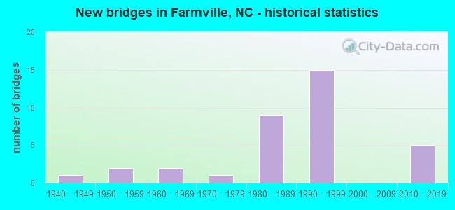
- New bridges - historical statistics
- 11940-1949
- 21950-1959
- 21960-1969
- 11970-1979
- 91980-1989
- 151990-1999
- 52010-2019
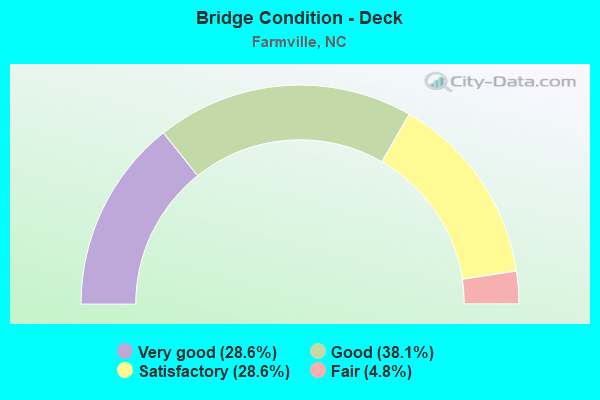
- Bridge Condition - Deck
- 28.6%Very good
- 38.1%Good
- 28.6%Satisfactory
- 4.8%Fair
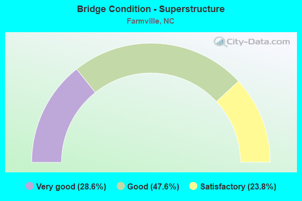
- Bridge Condition - Superstructure
- 28.6%Very good
- 47.6%Good
- 23.8%Satisfactory
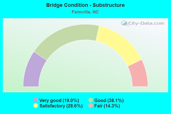
- Bridge Condition - Substructure
- 19.0%Very good
- 38.1%Good
- 28.6%Satisfactory
- 14.3%Fair
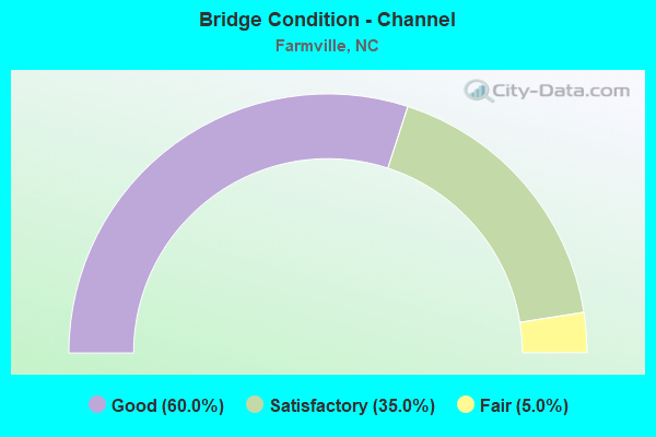
- Bridge Condition - Channel
- 60.0%Good
- 35.0%Satisfactory
- 5.0%Fair
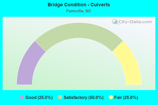
- Bridge Condition - Culverts
- 25.0%Good
- 50.0%Satisfactory
- 25.0%Fair
Find on map >> Show street view
Structure Number: 790007, Location: 0.6 MI. S. OF JCT SR1317 (Lat: 35.583439, Lng: -77.630950), Route carried "on" structure: State highway 1301, Year Built: 1976, Status: Posted for load, Structure Length: 1.52m (4.99ft), Average Daily Traffic: 440 (year 2018), Truck Traffic: 6%, Average Future Daily Traffic: 880 (year 2040), Features Intersected: MIDDLE SWAMP
Minimum Vertical Clearance: 30+ m (98+ ft), Kilometerpoint: 0.000, Lanes on structure: 2, Owner: State Highway Agency, Approaching Roadway Width: 5.7m (18.7ft), Material/Design: Wood or Timber, Design/Construction: Stringer/Multi-beam, Number Of Spans In Main Unit: 3, Length of Maximum Span: 4.8m (15.7ft), Curb or Sidewalk Widths: Left: 0.1m (0.3ft), Right: 0.1m (0.3ft), Curb-To-Curb Width: 8.5m (27.9ft), Out-to-Out Width: 8.9m (29.2ft)
Condition: Deck: Fair, Superstructure: Satisfactory, Substructure: Fair, Channel: Satisfactory, Operating Rating: 9.9 metric tons, Method Used To Determine Operating Rating: Allowable Stress (AS), Inventory Rating: 6.3 metric tons, Method Used To Determine Inventory Rating: Allowable Stress (AS), Structural Evaluation: High priority of corrective action, Deck Geometry: Somewhat better than minimum adequacy, Waterway Adequacy: Somewhat better than minimum adequacy, Approach Roadway Alignment: Equal to present desirable criteria, Bridge Posting: Required (Relationship of Operating Rating to Maximum Legal Load: > 39.9% below), Designated Inspection Frequency: Every 24 months, Underwater Inspection Frequency: Every 60 months, Inspection Date: December 2021, Underwater Inspection Date: December 2021, Deck Structure Type: Concrete Cast-file-Place, Wearing Surface/Protective System: Wearing Surface: Monolithic Concrete
Find on map >> Show street view
Structure Number: 790017, Location: 0.5 MI. N. JCT. SR1320 (Lat: 35.566108, Lng: -77.598578), Route carried "on" structure: US 258, Year Built: 1956, Status: Open, Structure Length: 0.94m (3.08ft), Average Daily Traffic: 4,900 (year 2019), Truck Traffic: 8%, Average Future Daily Traffic: 9,800 (year 2040), Design Load: HS 15, Features Intersected: MIDDLE SWAMP
Minimum Vertical Clearance: 30+ m (98+ ft), Kilometerpoint: 0.000, Lanes on structure: 2, Base Highway Network: Yes (Inventory Route: 2, Subroute: 58), Owner: State Highway Agency, Approaching Roadway Width: 7.9m (25.9ft), Material/Design: Steel, Design/Construction: Stringer/Multi-beam, Number Of Spans In Main Unit: 1, Length of Maximum Span: 8.8m (28.9ft), Curb-To-Curb Width: 7.9m (25.9ft), Out-to-Out Width: 9.5m (31.2ft)
Condition: Deck: Satisfactory, Superstructure: Good, Substructure: Satisfactory, Channel: Good, Operating Rating: 47.1 metric tons, Method Used To Determine Operating Rating: Load Factor (LF), Inventory Rating: 28.1 metric tons, Method Used To Determine Inventory Rating: Load Factor (LF), Structural Evaluation: Equal to present minimum criteria, Deck Geometry: High priority of corrective action, Waterway Adequacy: Better than present minimum criteria, Approach Roadway Alignment: Equal to present desirable criteria, Designated Inspection Frequency: Every 24 months, Underwater Inspection Frequency: Every 60 months, Inspection Date: December 2021, Underwater Inspection Date: May 2019, Deck Structure Type: Concrete Cast-file-Place, Wearing Surface/Protective System: Wearing Surface: Monolithic Concrete
Find on map >> Show street view
Structure Number: 79003, Location: 1.0 MI. S. JCT. US 13 (Lat: 35.531603, Lng: -77.558583), Route carried "on" structure: State highway 1345, Year Built: 1999, Status: Open, Structure Length: 3.10m (10.17ft), Average Daily Traffic: 130 (year 2000), Truck Traffic: 6%, Average Future Daily Traffic: 260 (year 2040), Design Load: HS 20+Mod, Features Intersected: SANDY RUN
Minimum Vertical Clearance: 30+ m (98+ ft), Kilometerpoint: 0.000, Lanes on structure: 2, Owner: State Highway Agency, Approaching Roadway Width: 6.7m (22.0ft), Material/Design: Prestressed concrete, Design/Construction: Slab, Number Of Spans In Main Unit: 3, Length of Maximum Span: 10.3m (33.8ft), Curb-To-Curb Width: 7.3m (24.0ft), Out-to-Out Width: 8.2m (26.9ft)
Condition: Deck: Very good, Superstructure: Very good, Substructure: Satisfactory, Channel: Good, Operating Rating: 89.8 metric tons, Method Used To Determine Operating Rating: Load Factor (LF), Inventory Rating: 54.4 metric tons, Method Used To Determine Inventory Rating: Load Factor (LF), Structural Evaluation: Equal to present minimum criteria, Deck Geometry: Somewhat better than minimum adequacy, Waterway Adequacy: Better than present minimum criteria, Approach Roadway Alignment: Equal to present desirable criteria, Designated Inspection Frequency: Every 24 months, Underwater Inspection Frequency: Every 60 months, Inspection Date: December 2021, Underwater Inspection Date: Febuary 2019, Deck Structure Type: Concrete Precast Panels, Wearing Surface/Protective System: Wearing Surface: Bituminous
Find on map >> Show street view
Structure Number: 790034, Location: 0.9 MI.N.JCT.SR1335 (Lat: 35.532361, Lng: -77.545325), Route carried "on" structure: State highway 1344, Year Built: 2014, Status: Open, Structure Length: 3.13m (10.27ft), Average Daily Traffic: 1,000 (year 2018), Truck Traffic: 6%, Average Future Daily Traffic: 2,000 (year 2040), Design Load: HL 93, Features Intersected: MIDDLE SWAMP
Minimum Vertical Clearance: 30+ m (98+ ft), Kilometerpoint: 0.000, Lanes on structure: 2, Owner: State Highway Agency, Approaching Roadway Width: 9.4m (30.8ft), Material/Design: Prestressed concrete, Design/Construction: Slab, Number Of Spans In Main Unit: 3, Length of Maximum Span: 10.3m (33.8ft), Curb-To-Curb Width: 9.1m (29.9ft), Out-to-Out Width: 10.0m (32.8ft)
Condition: Deck: Very good, Superstructure: Very good, Substructure: Very good, Channel: Good, Operating Rating: 49.8 metric tons, Method Used To Determine Operating Rating: Load and Resistance Factor (LRFR), Inventory Rating: 38.1 metric tons, Method Used To Determine Inventory Rating: Load and Resistance Factor (LRFR), Structural Evaluation: Equal to present desirable criteria, Deck Geometry: Equal to present minimum criteria, Waterway Adequacy: Better than present minimum criteria, Approach Roadway Alignment: Equal to present desirable criteria, Designated Inspection Frequency: Every 24 months, Underwater Inspection Frequency: Every 60 months, Inspection Date: January 2022, Underwater Inspection Date: June 2019, Deck Structure Type: Concrete Precast Panels, Wearing Surface/Protective System: Wearing Surface: Bituminous, Deck Protection: Epoxy Coated Reinforcing
Find on map >> Show street view
Structure Number: 790041, Location: 0.4 MI.N. JCT. SR1345 (Lat: 35.540689, Lng: -77.566675), Route carried "on" structure: US 13, Year Built: 1980, Status: Open, Structure Length: 3.10m (10.17ft), Average Daily Traffic: 5,300 (year 2019), Truck Traffic: 8%, Average Future Daily Traffic: 10,600 (year 2040), Design Load: HS 20+Mod, Features Intersected: MIDDLE SWAMP
Minimum Vertical Clearance: 30+ m (98+ ft), Kilometerpoint: 0.000, Lanes on structure: 2, Base Highway Network: Yes (Inventory Route: 2, Subroute: 13), Owner: State Highway Agency, Approaching Roadway Width: 8.2m (26.9ft), Material/Design: Prestressed concrete, Design/Construction: Slab, Number Of Spans In Main Unit: 3, Length of Maximum Span: 11.8m (38.7ft), Curb-To-Curb Width: 12.6m (41.3ft), Out-to-Out Width: 13.4m (44.0ft)
Condition: Deck: Satisfactory, Superstructure: Satisfactory, Substructure: Fair, Channel: Satisfactory, Operating Rating: 85.2 metric tons, Method Used To Determine Operating Rating: Load Factor (LF), Inventory Rating: 50.8 metric tons, Method Used To Determine Inventory Rating: Load Factor (LF), Structural Evaluation: Somewhat better than minimum adequacy, Deck Geometry: Somewhat better than minimum adequacy, Waterway Adequacy: Somewhat better than minimum adequacy, Approach Roadway Alignment: Equal to present desirable criteria, Designated Inspection Frequency: Every 24 months, Underwater Inspection Frequency: Every 60 months, Inspection Date: December 2021, Underwater Inspection Date: Febuary 2019, Deck Structure Type: Concrete Precast Panels, Wearing Surface/Protective System: Wearing Surface: Bituminous
Find on map >> Show street view
Structure Number: 1470014, Location: 5.0 MI. S. JCT. NC222 (Lat: 35.615006, Lng: -77.600419), Route carried "on" structure: US 258, Year Built: 1955, Status: Open, Structure Length: 2.65m (8.69ft), Average Daily Traffic: 5,200 (year 2018), Truck Traffic: 7%, Average Future Daily Traffic: 10,400 (year 2040), Design Load: HS 15, Features Intersected: LITTLE CONTENTNEA CREEK
Minimum Vertical Clearance: 30+ m (98+ ft), Kilometerpoint: 0.000, Lanes on structure: 2, Owner: State Highway Agency, Approaching Roadway Width: 7.6m (24.9ft), Material/Design: Steel continuous, Design/Construction: Stringer/Multi-beam, Number Of Spans In Main Unit: 2, Length of Maximum Span: 13.1m (43.0ft), Curb or Sidewalk Widths: Left: 0.5m (1.6ft), Right: 0.5m (1.6ft), Curb-To-Curb Width: 7.9m (25.9ft), Out-to-Out Width: 9.6m (31.5ft)
Condition: Deck: Satisfactory, Superstructure: Satisfactory, Substructure: Satisfactory, Channel: Good, Operating Rating: 47.1 metric tons, Method Used To Determine Operating Rating: Load Factor (LF), Inventory Rating: 28.1 metric tons, Method Used To Determine Inventory Rating: Load Factor (LF), Structural Evaluation: Equal to present minimum criteria, Deck Geometry: High priority of replacement, Waterway Adequacy: Better than present minimum criteria, Approach Roadway Alignment: Equal to present desirable criteria, Designated Inspection Frequency: Every 24 months, Inspection Date: August 2021, Deck Structure Type: Concrete Cast-file-Place, Wearing Surface/Protective System: Wearing Surface: Bituminous
Find on map >> Show street view
Structure Number: 1470026, Location: 0.8 MI N JCT US264A (Lat: 35.606756, Lng: -77.574692), Route carried "on" structure: State highway 121, Year Built: 1990, Status: Open, Structure Length: 5.02m (16.47ft), Average Daily Traffic: 2,800 (year 2018), Truck Traffic: 7%, Average Future Daily Traffic: 5,600 (year 2040), Design Load: HS 20+Mod, Features Intersected: LITTLE CONTENTNEA CREEK
Minimum Vertical Clearance: 30+ m (98+ ft), Kilometerpoint: 0.000, Lanes on structure: 2, Owner: State Highway Agency, Approaching Roadway Width: 9.7m (31.8ft), Material/Design: Prestressed concrete, Design/Construction: Stringer/Multi-beam, Number Of Spans In Main Unit: 3, Length of Maximum Span: 16.1m (52.8ft), Curb-To-Curb Width: 9.7m (31.8ft), Out-to-Out Width: 10.7m (35.1ft)
Condition: Deck: Satisfactory, Superstructure: Good, Substructure: Good, Channel: Good, Operating Rating: 89.8 metric tons, Method Used To Determine Operating Rating: Load Factor (LF), Inventory Rating: 39.9 metric tons, Method Used To Determine Inventory Rating: Load Factor (LF), Structural Evaluation: Better than present minimum criteria, Deck Geometry: Meets minimum limits, Waterway Adequacy: Better than present minimum criteria, Approach Roadway Alignment: Equal to present desirable criteria, Designated Inspection Frequency: Every 24 months, Underwater Inspection Frequency: Every 60 months, Inspection Date: July 2021, Underwater Inspection Date: November 2021, Deck Structure Type: Concrete Cast-file-Place, Wearing Surface/Protective System: Wearing Surface: Integral Concrete, Deck Protection: Epoxy Coated Reinforcing
Find on map >> Show street view
Structure Number: 1470069, Location: 0.9 MI. S. JCT. US13 (Lat: 35.533031, Lng: -77.545364), Route carried "on" structure: State highway 1139, Year Built: 2014, Status: Open, Structure Length: 2.65m (8.69ft), Average Daily Traffic: 1,300 (year 2019), Truck Traffic: 6%, Average Future Daily Traffic: 2,600 (year 2040), Design Load: HL 93, Features Intersected: MIDDLE SWAMP
Minimum Vertical Clearance: 30+ m (98+ ft), Kilometerpoint: 0.000, Lanes on structure: 2, Owner: State Highway Agency, Approaching Roadway Width: 9.4m (30.8ft), Material/Design: Prestressed concrete, Design/Construction: Slab, Number Of Spans In Main Unit: 2, Length of Maximum Span: 14.9m (48.9ft), Curb-To-Curb Width: 9.1m (29.9ft), Out-to-Out Width: 10.0m (32.8ft)
Condition: Deck: Very good, Superstructure: Very good, Substructure: Very good, Channel: Good, Operating Rating: 49.8 metric tons, Method Used To Determine Operating Rating: Load and Resistance Factor (LRFR), Inventory Rating: 38.1 metric tons, Method Used To Determine Inventory Rating: Load and Resistance Factor (LRFR), Structural Evaluation: Equal to present desirable criteria, Deck Geometry: Somewhat better than minimum adequacy, Waterway Adequacy: Better than present minimum criteria, Approach Roadway Alignment: Equal to present desirable criteria, Designated Inspection Frequency: Every 24 months, Underwater Inspection Frequency: Every 60 months, Inspection Date: August 2021, Underwater Inspection Date: December 2019, Deck Structure Type: Concrete Precast Panels, Wearing Surface/Protective System: Wearing Surface: Bituminous, Deck Protection: Epoxy Coated Reinforcing
Find on map >> Show street view
Structure Number: 1470073, Location: 0.8 MI S JCT SR 1200 (Lat: 35.613872, Lng: -77.646458), Route carried "on" structure: State highway 1229, Year Built: 1980, Status: Open, Structure Length: 3.10m (10.17ft), Average Daily Traffic: 420 (year 2016), Truck Traffic: 6%, Average Future Daily Traffic: 840 (year 2040), Design Load: HS 15, Features Intersected: CONTENTNEA CREEK
Minimum Vertical Clearance: 30+ m (98+ ft), Kilometerpoint: 0.000, Lanes on structure: 2, Owner: State Highway Agency, Approaching Roadway Width: 8.5m (27.9ft), Material/Design: Prestressed concrete, Design/Construction: Slab, Number Of Spans In Main Unit: 3, Length of Maximum Span: 11.8m (38.7ft), Curb or Sidewalk Widths: Left: 0.2m (0.7ft), Right: 0.2m (0.7ft), Curb-To-Curb Width: 9.2m (30.2ft), Out-to-Out Width: 10.1m (33.1ft)
Condition: Deck: Good, Superstructure: Good, Substructure: Satisfactory, Channel: Satisfactory, Operating Rating: 49.8 metric tons, Method Used To Determine Operating Rating: Load Factor (LF), Inventory Rating: 29.0 metric tons, Method Used To Determine Inventory Rating: Load Factor (LF), Structural Evaluation: Equal to present minimum criteria, Deck Geometry: Equal to present minimum criteria, Waterway Adequacy: Better than present minimum criteria, Approach Roadway Alignment: Equal to present desirable criteria, Designated Inspection Frequency: Every 24 months, Inspection Date: July 2021, Deck Structure Type: Concrete Precast Panels, Wearing Surface/Protective System: Wearing Surface: Bituminous
Find on map >> Show street view
Structure Number: 1470075, Location: 1.0 MI. W.JCT. SR1217 (Lat: 35.587178, Lng: -77.543094), Route carried "on" structure: State highway 1218, Year Built: 1962, Status: Open, Structure Length: 1.52m (4.99ft), Average Daily Traffic: 850 (year 2018), Truck Traffic: 6%, Average Future Daily Traffic: 1,700 (year 2040), Design Load: H 15, Features Intersected: LITTLE CONTENTNEA CREEK
Minimum Vertical Clearance: 30+ m (98+ ft), Kilometerpoint: 0.000, Lanes on structure: 2, Owner: State Highway Agency, Approaching Roadway Width: 5.4m (17.7ft), Material/Design: Steel, Design/Construction: Stringer/Multi-beam, Number Of Spans In Main Unit: 2, Length of Maximum Span: 7.0m (23.0ft), Curb or Sidewalk Widths: Left: 0.3m (1.0ft), Right: 0.3m (1.0ft), Curb-To-Curb Width: 7.3m (24.0ft), Out-to-Out Width: 8.6m (28.2ft)
Condition: Deck: Satisfactory, Superstructure: Satisfactory, Substructure: Fair, Channel: Good, Operating Rating: 51.7 metric tons, Method Used To Determine Operating Rating: Load Factor (LF), Inventory Rating: 30.8 metric tons, Method Used To Determine Inventory Rating: Load Factor (LF), Structural Evaluation: Somewhat better than minimum adequacy, Deck Geometry: Meets minimum limits, Waterway Adequacy: Better than present minimum criteria, Approach Roadway Alignment: Equal to present desirable criteria, Designated Inspection Frequency: Every 24 months, Underwater Inspection Frequency: Every 60 months, Inspection Date: August 2021, Underwater Inspection Date: November 2020, Deck Structure Type: Concrete Cast-file-Place, Wearing Surface/Protective System: Wearing Surface: Monolithic Concrete
Find on map >> Show street view
Structure Number: 1470076, Location: 0.9 MI. S. JCT. SR1217 (Lat: 35.588036, Lng: -77.541614), Route carried "on" structure: State highway 1218, Year Built: 1963, Status: Posted for load, Structure Length: 3.20m (10.50ft), Average Daily Traffic: 850 (year 2018), Truck Traffic: 6%, Average Future Daily Traffic: 1,700 (year 2040), Design Load: H 15, Features Intersected: LITTLE CONTENTNEA CREEK
Minimum Vertical Clearance: 30+ m (98+ ft), Kilometerpoint: 0.000, Lanes on structure: 2, Owner: State Highway Agency, Approaching Roadway Width: 5.4m (17.7ft), Skew: 2 degrees, Material/Design: Steel, Design/Construction: Stringer/Multi-beam, Number Of Spans In Main Unit: 3, Length of Maximum Span: 10.3m (33.8ft), Curb or Sidewalk Widths: Left: 0.3m (1.0ft), Right: 0.3m (1.0ft), Curb-To-Curb Width: 7.3m (24.0ft), Out-to-Out Width: 8.6m (28.2ft)
Condition: Deck: Satisfactory, Superstructure: Good, Substructure: Satisfactory, Channel: Good, Operating Rating: 39.0 metric tons, Method Used To Determine Operating Rating: Load Factor (LF), Inventory Rating: 23.5 metric tons, Method Used To Determine Inventory Rating: Load Factor (LF), Structural Evaluation: Equal to present minimum criteria, Deck Geometry: Meets minimum limits, Waterway Adequacy: Equal to present minimum criteria, Approach Roadway Alignment: Equal to present minimum criteria, Bridge Posting: Required (Relationship of Operating Rating to Maximum Legal Load: 10.0 - 19.9% below), Designated Inspection Frequency: Every 24 months, Underwater Inspection Frequency: Every 60 months, Inspection Date: August 2021, Underwater Inspection Date: November 2021, Deck Structure Type: Concrete Cast-file-Place, Wearing Surface/Protective System: Wearing Surface: Monolithic Concrete
Find on map >> Show street view
Structure Number: 1470079, Location: 0.4 MI E JCT SR1221 (Lat: 35.606989, Lng: -77.548586), Route carried "on" structure: State highway 1200, Year Built: 2012, Status: Open, Structure Length: 2.49m (8.17ft), Average Daily Traffic: 2,000 (year 2018), Truck Traffic: 7%, Average Future Daily Traffic: 4,000 (year 2040), Design Load: HL 93, Features Intersected: OLD WOMAN CANAL
Minimum Vertical Clearance: 30+ m (98+ ft), Kilometerpoint: 0.000, Lanes on structure: 2, Owner: State Highway Agency, Approaching Roadway Width: 9.4m (30.8ft), Skew: 1 degrees, Material/Design: Prestressed concrete, Design/Construction: Slab, Number Of Spans In Main Unit: 2, Length of Maximum Span: 16.7m (54.8ft), Curb-To-Curb Width: 9.1m (29.9ft), Out-to-Out Width: 10.0m (32.8ft)
Condition: Deck: Very good, Superstructure: Very good, Substructure: Good, Channel: Satisfactory, Operating Rating: 56.2 metric tons, Method Used To Determine Operating Rating: Load and Resistance Factor (LRFR), Inventory Rating: 43.5 metric tons, Method Used To Determine Inventory Rating: Load and Resistance Factor (LRFR), Structural Evaluation: Better than present minimum criteria, Deck Geometry: Somewhat better than minimum adequacy, Waterway Adequacy: Better than present minimum criteria, Approach Roadway Alignment: Equal to present minimum criteria, Designated Inspection Frequency: Every 24 months, Inspection Date: August 2021, Deck Structure Type: Concrete Precast Panels, Wearing Surface/Protective System: Wearing Surface: Bituminous, Deck Protection: Epoxy Coated Reinforcing
Find on map >> Show street view
Structure Number: 147008, Location: 0.5 MI W. OF JCT SR1243 (Lat: 35.625039, Lng: -77.592806), Route carried "on" structure: State highway 1200, Year Built: 2016, Status: Open, Structure Length: 2.74m (8.99ft), Average Daily Traffic: 1,100 (year 2018), Truck Traffic: 7%, Average Future Daily Traffic: 2,200 (year 2025), Design Load: HL 93, Features Intersected: LANGS MILL RUN
Minimum Vertical Clearance: 30+ m (98+ ft), Kilometerpoint: 0.000, Lanes on structure: 2, Owner: State Highway Agency, Approaching Roadway Width: 8.5m (27.9ft), Skew: 1 degrees, Material/Design: Prestressed concrete, Design/Construction: Slab, Number Of Spans In Main Unit: 3, Length of Maximum Span: 12.4m (40.7ft), Curb-To-Curb Width: 8.2m (26.9ft), Out-to-Out Width: 9.1m (29.9ft)
Condition: Deck: Very good, Superstructure: Very good, Substructure: Very good, Channel: Satisfactory, Operating Rating: 68.0 metric tons, Method Used To Determine Operating Rating: Load and Resistance Factor (LRFR), Inventory Rating: 45.3 metric tons, Method Used To Determine Inventory Rating: Load and Resistance Factor (LRFR), Structural Evaluation: Equal to present desirable criteria, Deck Geometry: Meets minimum limits, Waterway Adequacy: Better than present minimum criteria, Approach Roadway Alignment: Equal to present desirable criteria, Designated Inspection Frequency: Every 24 months, Inspection Date: July 2021, Deck Structure Type: Concrete Precast Panels, Wearing Surface/Protective System: Wearing Surface: Bituminous, Deck Protection: Epoxy Coated Reinforcing
Find on map >> Show street view
Structure Number: 1470081, Location: 0.35 MI E JCT SR 1241 (Lat: 35.593639, Lng: -77.604861), Route carried "on" structure: State highway 1200, Year Built: 2014, Status: Open, Structure Length: 2.13m (6.99ft), Average Daily Traffic: 1,100 (year 2018), Truck Traffic: 7%, Average Future Daily Traffic: 2,200 (year 2040), Design Load: HL 93, Features Intersected: JACOB BRANCH
Minimum Vertical Clearance: 30+ m (98+ ft), Kilometerpoint: 0.000, Lanes on structure: 2, Owner: State Highway Agency, Approaching Roadway Width: 8.8m (28.9ft), Material/Design: Prestressed concrete, Design/Construction: Slab, Number Of Spans In Main Unit: 1, Length of Maximum Span: 20.4m (66.9ft), Curb-To-Curb Width: 8.3m (27.2ft), Out-to-Out Width: 9.1m (29.9ft)
Condition: Deck: Very good, Superstructure: Very good, Substructure: Very good, Channel: Good, Operating Rating: 59.8 metric tons, Method Used To Determine Operating Rating: Load and Resistance Factor (LRFR), Inventory Rating: 41.7 metric tons, Method Used To Determine Inventory Rating: Load and Resistance Factor (LRFR), Structural Evaluation: Equal to present desirable criteria, Deck Geometry: Meets minimum limits, Waterway Adequacy: Better than present minimum criteria, Approach Roadway Alignment: Equal to present desirable criteria, Designated Inspection Frequency: Every 24 months, Inspection Date: August 2021, Deck Structure Type: Concrete Precast Panels, Wearing Surface/Protective System: Wearing Surface: Bituminous, Deck Protection: Epoxy Coated Reinforcing
Find on map >> Show street view
Structure Number: 1470082, Location: 0.7 MI. N. JCT. NC121 (Lat: 35.611375, Lng: -77.616469), Route carried "on" structure: State highway 2107, Year Built: 1949, Status: Posted for load, Structure Length: 1.00m (3.28ft), Average Daily Traffic: 30 (year 1992), Average Future Daily Traffic: 60 (year 2040), Features Intersected: LITTLE CONTENTNEA CREEK
Minimum Vertical Clearance: 30+ m (98+ ft), Kilometerpoint: 0.000, Lanes on structure: 2, Owner: State Highway Agency, Approaching Roadway Width: 4.8m (15.7ft), Material/Design: Steel, Design/Construction: Stringer/Multi-beam, Number Of Spans In Main Unit: 1, Length of Maximum Span: 9.7m (31.8ft), Curb or Sidewalk Widths: Left: 0.1m (0.3ft), Right: 0.1m (0.3ft), Curb-To-Curb Width: 5.8m (19.0ft), Out-to-Out Width: 6.1m (20.0ft)
Condition: Deck: Good, Superstructure: Satisfactory, Substructure: Satisfactory, Channel: Good, Operating Rating: 22.6 metric tons, Method Used To Determine Operating Rating: Load Factor (LF), Inventory Rating: 13.6 metric tons, Method Used To Determine Inventory Rating: Load Factor (LF), Structural Evaluation: Meets minimum limits, Deck Geometry: Meets minimum limits, Waterway Adequacy: Better than present minimum criteria, Approach Roadway Alignment: Equal to present desirable criteria, Bridge Posting: Required (Relationship of Operating Rating to Maximum Legal Load: > 39.9% below), Designated Inspection Frequency: Every 24 months, Inspection Date: August 2021, Deck Structure Type: Wood or Timber, Wearing Surface/Protective System: Wearing Surface: Wood or Timber
Find on map >> Show street view
Structure Number: 1470432, Location: 0.7 MI.N.JCT.US264 (Lat: 35.595803, Lng: -77.557861), Route carried "on" structure: Bypass US 258, Year Built: 1985, Status: Open, Structure Length: 5.48m (17.98ft), Average Daily Traffic: 7,200 (year 2017), Truck Traffic: 8%, Average Future Daily Traffic: 14,400 (year 2040), Design Load: HS 20+Mod, Features Intersected: LITTLE CONTENTNEA CREEK
Minimum Vertical Clearance: 30+ m (98+ ft), Kilometerpoint: 0.000, Lanes on structure: 2, Base Highway Network: Yes, Owner: State Highway Agency, Approaching Roadway Width: 12.4m (40.7ft), Skew: 1 degrees, Material/Design: Prestressed concrete, Design/Construction: Stringer/Multi-beam, Number Of Spans In Main Unit: 3, Length of Maximum Span: 17.9m (58.7ft), Curb-To-Curb Width: 12.2m (40.0ft), Out-to-Out Width: 13.1m (43.0ft)
Condition: Deck: Good, Superstructure: Good, Substructure: Good, Channel: Satisfactory, Operating Rating: 89.8 metric tons, Method Used To Determine Operating Rating: Load Factor (LF), Inventory Rating: 37.1 metric tons, Method Used To Determine Inventory Rating: Load Factor (LF), Structural Evaluation: Better than present minimum criteria, Deck Geometry: Somewhat better than minimum adequacy, Waterway Adequacy: Better than present minimum criteria, Approach Roadway Alignment: Equal to present desirable criteria, Designated Inspection Frequency: Every 24 months, Inspection Date: August 2021, Deck Structure Type: Concrete Cast-file-Place, Wearing Surface/Protective System: Wearing Surface: Monolithic Concrete
Find on map >> Show street view
Structure Number: 1470439, Location: 0.5 MI.W.JCT.SR1229 (Lat: 35.615939, Lng: -77.653367), Route carried "on" structure: US 264, Year Built: 1989, Status: Open, Structure Length: 1.52m (4.99ft), Average Daily Traffic: 21,500 (year 2019), Truck Traffic: 14%, Average Future Daily Traffic: 43,000 (year 2025), Design Load: HS 20+Mod, Features Intersected: LITTLE CONTENTNEA CREEK
Minimum Vertical Clearance: 30+ m (98+ ft), Kilometerpoint: 0.000, Lanes on structure: 4, Base Highway Network: Yes (Inventory Route: 2, Subroute: 64), Owner: State Highway Agency, Approaching Roadway Width: 19.8m (65.0ft), Skew: 4 degrees, Material/Design: Concrete continuous, Design/Construction: Culvert, Number Of Spans In Main Unit: 3, Length of Maximum Span: 3.3m (10.8ft)
Condition: Channel: Good, Culverts: Fair, Operating Rating: 51.7 metric tons, Method Used To Determine Operating Rating: Load and Resistance Factor (LRFR), Inventory Rating: 39.9 metric tons, Method Used To Determine Inventory Rating: Load and Resistance Factor (LRFR), Structural Evaluation: Somewhat better than minimum adequacy, Waterway Adequacy: Better than present minimum criteria, Approach Roadway Alignment: Equal to present desirable criteria, Designated Inspection Frequency: Every 24 months, Underwater Inspection Frequency: Every 60 months, Inspection Date: April 2021, Underwater Inspection Date: April 2021
Find on map >> Show street view
Structure Number: 147044, Location: 0.05 MI.S.JCT.SR1200 (Lat: 35.616322, Lng: -77.643292), Route carried "on" structure: State highway 1229, Year Built: 1989, Status: Open, Structure Length: 8.10m (26.57ft), Average Daily Traffic: 800 (year 2018), Truck Traffic: 7%, Average Future Daily Traffic: 1,600 (year 2025), Design Load: HS 20+Mod, Features Intersected: US264
Minimum Vertical Clearance: 30+ m (98+ ft), Kilometerpoint: 0.000, Lanes on structure: 2, Lanes under structure: 4, Owner: State Highway Agency, Approaching Roadway Width: 7.3m (24.0ft), Skew: 4 degrees, Material/Design: Prestressed concrete, Design/Construction: Stringer/Multi-beam, Number Of Spans In Main Unit: 4, Length of Maximum Span: 25.2m (82.7ft), Curb-To-Curb Width: 7.2m (23.6ft), Out-to-Out Width: 8.2m (26.9ft)
Condition: Deck: Good, Superstructure: Good, Substructure: Good, Operating Rating: 82.5 metric tons, Method Used To Determine Operating Rating: Load Factor (LF), Inventory Rating: 40.8 metric tons, Method Used To Determine Inventory Rating: Load Factor (LF), Structural Evaluation: Better than present minimum criteria, Deck Geometry: Meets minimum limits, Underclear: Somewhat better than minimum adequacy, Approach Roadway Alignment: Equal to present desirable criteria, Designated Inspection Frequency: Every 24 months, Inspection Date: July 2021, Deck Structure Type: Concrete Cast-file-Place, Wearing Surface/Protective System: Wearing Surface: Integral Concrete, Deck Protection: Epoxy Coated Reinforcing
Find on map >> Show street view
Structure Number: 1470441, Location: 0.8MI.E. JCT.SR1221 (Lat: 35.596278, Lng: -77.543700), Route carried "on" structure: US 264, Year Built: 1986, Status: Open, Structure Length: 0.64m (2.10ft), Average Daily Traffic: 24,000 (year 2017), Truck Traffic: 14%, Average Future Daily Traffic: 48,000 (year 2040), Design Load: HS 20+Mod, Features Intersected: OLD WOMAN CANAL
Minimum Vertical Clearance: 30+ m (98+ ft), Kilometerpoint: 0.000, Lanes on structure: 4, Base Highway Network: Yes (Inventory Route: 2, Subroute: 64), Owner: State Highway Agency, Approaching Roadway Width: 19.5m (64.0ft), Skew: 1 degrees, Material/Design: Concrete continuous, Design/Construction: Culvert, Number Of Spans In Main Unit: 2, Length of Maximum Span: 3.0m (9.8ft)
Condition: Channel: Fair, Culverts: Satisfactory, Operating Rating: 89.8 metric tons, Method Used To Determine Operating Rating: Load and Resistance Factor (LRFR), Inventory Rating: 74.3 metric tons, Method Used To Determine Inventory Rating: Load and Resistance Factor (LRFR), Structural Evaluation: Equal to present minimum criteria, Waterway Adequacy: Better than present minimum criteria, Approach Roadway Alignment: Equal to present desirable criteria, Designated Inspection Frequency: Every 24 months, Underwater Inspection Frequency: Every 60 months, Inspection Date: January 2022, Underwater Inspection Date: January 2022
Find on map >> Show street view
Structure Number: 1470445, Location: 0.6MI.W.JCT.SR1229 (Lat: 35.615497, Lng: -77.654961), Route carried "on" structure: US 264, Year Built: 1989, Status: Open, Structure Length: 0.85m (2.79ft), Average Daily Traffic: 18,000 (year 2018), Truck Traffic: 14%, Average Future Daily Traffic: 36,000 (year 2040), Design Load: HS 20+Mod, Features Intersected: THOMPSON CANAL
Minimum Vertical Clearance: 30+ m (98+ ft), Kilometerpoint: 18.318, Lanes on structure: 4, Base Highway Network: Yes (Inventory Route: 2, Subroute: 64), Owner: State Highway Agency, Approaching Roadway Width: 19.5m (64.0ft), Skew: 5 degrees, Material/Design: Concrete continuous, Design/Construction: Culvert, Number Of Spans In Main Unit: 1, Length of Maximum Span: 4.5m (14.8ft)
Condition: Channel: Good, Culverts: Good, Operating Rating: 85.2 metric tons, Method Used To Determine Operating Rating: Load and Resistance Factor (LRFR), Inventory Rating: 65.3 metric tons, Method Used To Determine Inventory Rating: Load and Resistance Factor (LRFR), Structural Evaluation: Better than present minimum criteria, Waterway Adequacy: Better than present minimum criteria, Approach Roadway Alignment: Equal to present desirable criteria, Designated Inspection Frequency: Every 24 months, Inspection Date: July 2021
Find on map >> Show street view
Structure Number: 1470446, Location: 0.2MI.S.JCT SR1200 (Lat: 35.608811, Lng: -77.573708), Route carried "on" structure: State highway 121, Year Built: 1990, Status: Open, Structure Length: 6.43m (21.10ft), Average Daily Traffic: 2,800 (year 2018), Truck Traffic: 7%, Average Future Daily Traffic: 5,600 (year 2040), Design Load: HS 20+Mod, Features Intersected: US264
Minimum Vertical Clearance: 30+ m (98+ ft), Kilometerpoint: 0.000, Lanes on structure: 2, Lanes under structure: 4, Owner: State Highway Agency, Approaching Roadway Width: 9.7m (31.8ft), Skew: 1 degrees, Material/Design: Prestressed concrete, Design/Construction: Stringer/Multi-beam, Number Of Spans In Main Unit: 4, Length of Maximum Span: 19.8m (65.0ft), Curb-To-Curb Width: 9.7m (31.8ft), Out-to-Out Width: 10.6m (34.8ft)
Condition: Deck: Good, Superstructure: Good, Substructure: Good, Operating Rating: 65.3 metric tons, Method Used To Determine Operating Rating: Load Factor (LF), Inventory Rating: 38.1 metric tons, Method Used To Determine Inventory Rating: Load Factor (LF), Structural Evaluation: Better than present minimum criteria, Deck Geometry: Meets minimum limits, Underclear: Somewhat better than minimum adequacy, Approach Roadway Alignment: Equal to present desirable criteria, Designated Inspection Frequency: Every 24 months, Inspection Date: July 2021, Deck Structure Type: Concrete Cast-file-Place, Wearing Surface/Protective System: Wearing Surface: Integral Concrete
Find on map >> Show street view
Structure Number: 1470447, Location: 0.6 MI. W. JCT. SR1200 (Lat: 35.618800, Lng: -77.606056), Route carried "on" structure: US 264, Year Built: 1990, Status: Open, Structure Length: 4.63m (15.19ft), Average Daily Traffic: 9,750 (year 2018), Truck Traffic: 14%, Average Future Daily Traffic: 19,500 (year 2040), Design Load: HS 20+Mod, Features Intersected: US258
Minimum Vertical Clearance: 30+ m (98+ ft), Kilometerpoint: 0.000, Lanes on structure: 2, Lanes under structure: 3, Base Highway Network: Yes (Inventory Route: 2, Subroute: 64), Owner: State Highway Agency, Approaching Roadway Width: 11.8m (38.7ft), Skew: 12 degrees, Material/Design: Prestressed concrete, Design/Construction: Stringer/Multi-beam, Number Of Spans In Main Unit: 3, Length of Maximum Span: 21.0m (68.9ft), Curb-To-Curb Width: 11.6m (38.1ft), Out-to-Out Width: 12.5m (41.0ft)
Condition: Deck: Good, Superstructure: Good, Substructure: Good, Operating Rating: 64.4 metric tons, Method Used To Determine Operating Rating: Load Factor (LF), Inventory Rating: 38.1 metric tons, Method Used To Determine Inventory Rating: Load Factor (LF), Structural Evaluation: Better than present minimum criteria, Deck Geometry: Better than present minimum criteria, Underclear: Somewhat better than minimum adequacy, Approach Roadway Alignment: Equal to present desirable criteria, Designated Inspection Frequency: Every 24 months, Inspection Date: August 2021, Deck Structure Type: Concrete Cast-file-Place, Wearing Surface/Protective System: Wearing Surface: Integral Concrete, Deck Protection: Epoxy Coated Reinforcing
Find on map >> Show street view
Structure Number: 1470448, Location: 0.6MI.W.JCT.SR1200 (Lat: 35.618633, Lng: -77.605817), Route carried "on" structure: US 264, Year Built: 1990, Status: Open, Structure Length: 4.51m (14.80ft), Average Daily Traffic: 9,750 (year 2018), Truck Traffic: 14%, Average Future Daily Traffic: 19,500 (year 2040), Design Load: HS 20+Mod, Features Intersected: US258
Minimum Vertical Clearance: 30+ m (98+ ft), Kilometerpoint: 19.202, Lanes on structure: 2, Lanes under structure: 3, Base Highway Network: Yes (Inventory Route: 2, Subroute: 64), Owner: State Highway Agency, Approaching Roadway Width: 11.8m (38.7ft), Skew: 12 degrees, Material/Design: Prestressed concrete, Design/Construction: Stringer/Multi-beam, Number Of Spans In Main Unit: 3, Length of Maximum Span: 21.0m (68.9ft), Curb-To-Curb Width: 11.5m (37.7ft), Out-to-Out Width: 12.5m (41.0ft)
Condition: Deck: Good, Superstructure: Good, Substructure: Good, Operating Rating: 72.5 metric tons, Method Used To Determine Operating Rating: Load Factor (LF), Inventory Rating: 40.8 metric tons, Method Used To Determine Inventory Rating: Load Factor (LF), Structural Evaluation: Better than present minimum criteria, Deck Geometry: Equal to present minimum criteria, Underclear: Equal to present minimum criteria, Approach Roadway Alignment: Equal to present desirable criteria, Designated Inspection Frequency: Every 24 months, Inspection Date: August 2021, Deck Structure Type: Concrete Cast-file-Place, Wearing Surface/Protective System: Wearing Surface: Integral Concrete
Find on map >> Show street view
Structure Number: 1470449, Location: 0.5 MI. E. JCT. US258 (Lat: 35.616731, Lng: -77.583564), Route carried "on" structure: US 264, Year Built: 1990, Status: Open, Structure Length: 0.94m (3.08ft), Average Daily Traffic: 19,500 (year 2018), Truck Traffic: 14%, Average Future Daily Traffic: 39,000 (year 2040), Design Load: HL 93, Features Intersected: JACOBS BRANCH
Minimum Vertical Clearance: 30+ m (98+ ft), Kilometerpoint: 19.324, Lanes on structure: 4, Base Highway Network: Yes (Inventory Route: 2, Subroute: 64), Owner: State Highway Agency, Approaching Roadway Width: 24.0m (78.7ft), Material/Design: Concrete continuous, Design/Construction: Culvert, Number Of Spans In Main Unit: 2, Length of Maximum Span: 4.5m (14.8ft)
Condition: Channel: Satisfactory, Culverts: Satisfactory, Operating Rating: 54.4 metric tons, Method Used To Determine Operating Rating: Load and Resistance Factor (LRFR), Inventory Rating: 41.7 metric tons, Method Used To Determine Inventory Rating: Load and Resistance Factor (LRFR), Structural Evaluation: Equal to present minimum criteria, Waterway Adequacy: Equal to present minimum criteria, Approach Roadway Alignment: Equal to present desirable criteria, Designated Inspection Frequency: Every 24 months, Inspection Date: August 2021
Find on map >> Show street view
Structure Number: 1470471, Location: 0.7 MI.S.JCT.SR1200 (Lat: 35.598569, Lng: -77.557342), Route carried "on" structure: Bypass US 258, Year Built: 1998, Status: Open, Structure Length: 5.82m (19.09ft), Average Daily Traffic: 7,500 (year 2018), Truck Traffic: 8%, Average Future Daily Traffic: 15,000 (year 2040), Design Load: HS 20+Mod, Features Intersected: US264
Minimum Vertical Clearance: 30+ m (98+ ft), Kilometerpoint: 0.000, Lanes on structure: 2, Lanes under structure: 4, Base Highway Network: Yes (Inventory Route: 2, Subroute: 58), Owner: State Highway Agency, Approaching Roadway Width: 17.3m (56.8ft), Skew: 1 degrees, Material/Design: Prestressed concrete continuous, Design/Construction: Stringer/Multi-beam, Number Of Spans In Main Unit: 2, Length of Maximum Span: 29.2m (95.8ft), Curb-To-Curb Width: 17.4m (57.1ft), Out-to-Out Width: 18.4m (60.4ft)
Condition: Deck: Good, Superstructure: Good, Substructure: Good, Operating Rating: 89.8 metric tons, Method Used To Determine Operating Rating: Load Factor (LF), Inventory Rating: 51.7 metric tons, Method Used To Determine Inventory Rating: Load Factor (LF), Structural Evaluation: Better than present minimum criteria, Deck Geometry: Superior to present desirable criteria, Underclear: Equal to present minimum criteria, Approach Roadway Alignment: Equal to present desirable criteria, Designated Inspection Frequency: Every 24 months, Inspection Date: August 2021, Deck Structure Type: Concrete Cast-file-Place, Wearing Surface/Protective System: Wearing Surface: Monolithic Concrete, Deck Protection: Epoxy Coated Reinforcing
Find on map >> Show street view
Structure Number: 7901, Location: 0.3 MI.W.NC121 (Lat: 35.614331, Lng: -77.660094), Route carried "under" structure: US 264, Year Built: 1997, Structure Length: 0. m, Average Daily Traffic: 10,750 (year 2019), Truck Traffic: 14%, Features Intersected: US264W,RAMP
Minimum Vertical Clearance: 5.46m (17.91ft), Kilometerpoint: 18.227, Lanes on structure: 1, Lanes under structure: 2, Material/Design: Prestressed concrete, Design/Construction: Stringer/Multi-beam, Length of Maximum Span: 29.2m (95.8ft)
Find on map >> Show street view
Structure Number: 7901, Location: 0.3 MI.W.NC121 (Lat: 35.614331, Lng: -77.660094), Route carried "under" structure: US 264, Year Built: 1997, Structure Length: 0. m, Average Daily Traffic: 10,750 (year 2019), Truck Traffic: 14%, Features Intersected: US264W,RAMP
Minimum Vertical Clearance: 5.48m (17.98ft), Kilometerpoint: 18.227, Lanes on structure: 1, Lanes under structure: 2, Material/Design: Prestressed concrete, Design/Construction: Stringer/Multi-beam, Length of Maximum Span: 29.2m (95.8ft)
Find on map >> Show street view
Structure Number: 147044, Location: 0.05 MI.S.JCT.SR1200 (Lat: 35.616322, Lng: -77.643292), Route carried "under" structure: US 264, Year Built: 1989, Structure Length: 0. m, Average Daily Traffic: 9,500 (year 2018), Truck Traffic: 14%, Features Intersected: SR1229
Minimum Vertical Clearance: 5.33m (17.49ft), Kilometerpoint: 18.532, Lanes on structure: 2, Lanes under structure: 2, Material/Design: Prestressed concrete, Design/Construction: Stringer/Multi-beam, Length of Maximum Span: 25.2m (82.7ft)
Find on map >> Show street view
Structure Number: 147044, Location: 0.05 MI.S.JCT.SR1200 (Lat: 35.616322, Lng: -77.643292), Route carried "under" structure: US 264, Year Built: 1989, Structure Length: 0. m, Average Daily Traffic: 9,500 (year 2018), Truck Traffic: 14%, Features Intersected: SR1229
Minimum Vertical Clearance: 5.10m (16.73ft), Kilometerpoint: 18.532, Lanes on structure: 2, Lanes under structure: 2, Material/Design: Prestressed concrete, Design/Construction: Stringer/Multi-beam, Length of Maximum Span: 25.2m (82.7ft)
Find on map >> Show street view
Structure Number: 1470446, Location: 0.2MI.S.JCT SR1200 (Lat: 35.608811, Lng: -77.573708), Route carried "under" structure: US 264, Year Built: 1990, Structure Length: 0. m, Average Daily Traffic: 9,500 (year 2015), Truck Traffic: 14%, Features Intersected: NC121
Minimum Vertical Clearance: 5.25m (17.22ft), Kilometerpoint: 19.812, Lanes on structure: 2, Lanes under structure: 2, Material/Design: Prestressed concrete, Design/Construction: Stringer/Multi-beam, Length of Maximum Span: 19.8m (65.0ft)
Find on map >> Show street view
Structure Number: 1470446, Location: 0.2MI.S.JCT SR1200 (Lat: 35.608811, Lng: -77.573708), Route carried "under" structure: US 264, Year Built: 1990, Structure Length: 0. m, Average Daily Traffic: 9,500 (year 2015), Truck Traffic: 14%, Features Intersected: NC121
Minimum Vertical Clearance: 5.13m (16.83ft), Kilometerpoint: 19.812, Lanes on structure: 2, Lanes under structure: 2, Material/Design: Prestressed concrete, Design/Construction: Stringer/Multi-beam, Length of Maximum Span: 19.8m (65.0ft)
Find on map >> Show street view
Structure Number: 1470447, Location: 0.6 MI. W. JCT. SR1200 (Lat: 35.618800, Lng: -77.606056), Route carried "under" structure: US 258, Year Built: 1990, Structure Length: 0. m, Average Daily Traffic: 5,900 (year 2019), Truck Traffic: 8%, Features Intersected: US264E
Minimum Vertical Clearance: 5.53m (18.14ft), Kilometerpoint: 0.000, Lanes on structure: 2, Lanes under structure: 3, Material/Design: Prestressed concrete, Design/Construction: Stringer/Multi-beam, Length of Maximum Span: 21.0m (68.9ft)
Find on map >> Show street view
Structure Number: 1470448, Location: 0.6MI.W.JCT.SR1200 (Lat: 35.618633, Lng: -77.605817), Route carried "under" structure: US 258, Year Built: 1990, Structure Length: 0. m, Average Daily Traffic: 5,900 (year 2018), Truck Traffic: 7%, Features Intersected: US264 WBL
Minimum Vertical Clearance: 5.13m (16.83ft), Kilometerpoint: 0.000, Lanes on structure: 2, Lanes under structure: 3, Material/Design: Prestressed concrete, Design/Construction: Stringer/Multi-beam, Length of Maximum Span: 21.0m (68.9ft)
Find on map >> Show street view
Structure Number: 1470471, Location: 0.7 MI.S.JCT.SR1200 (Lat: 35.598569, Lng: -77.557342), Route carried "under" structure: US 264, Year Built: 1998, Structure Length: 0. m, Average Daily Traffic: 10,750 (year 2018), Truck Traffic: 14%, Features Intersected: US258BYPASS
Minimum Vertical Clearance: 5.46m (17.91ft), Kilometerpoint: 20.117, Lanes on structure: 2, Lanes under structure: 2, Material/Design: Prestressed concrete continuous, Design/Construction: Stringer/Multi-beam, Length of Maximum Span: 29.2m (95.8ft)
Find on map >> Show street view
Structure Number: 1470471, Location: 0.7 MI.S.JCT.SR1200 (Lat: 35.598569, Lng: -77.557342), Route carried "under" structure: US 264, Year Built: 1998, Structure Length: 0. m, Average Daily Traffic: 10,750 (year 2018), Truck Traffic: 14%, Features Intersected: US258BYPASS
Minimum Vertical Clearance: 6.17m (20.24ft), Kilometerpoint: 20.117, Lanes on structure: 2, Lanes under structure: 2, Material/Design: Prestressed concrete continuous, Design/Construction: Stringer/Multi-beam, Length of Maximum Span: 29.2m (95.8ft)