Bridge Statistics for Farmingdale, New Jersey (NJ)
Condition, Traffic, Stress, Structural Evaluation, Project Costs
- National Bridge Inventory (NBI) Statistics
- 41Number of bridges
- 394ft / 120mTotal length
- $18,774,000Total costs
- 856,071Total average daily traffic
- 77,267Total average daily truck traffic
- National Bridge Inventory (NBI) Registered Bridges for Farmingdale
- No street view available for this location
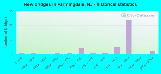
- New bridges - historical statistics
- 1Before 1900
- 11900-1909
- 11920-1929
- 11930-1939
- 41940-1949
- 11950-1959
- 11960-1969
- 51970-1979
- 241980-1989
- 22000-2009

- Reconstructed bridges - Historical Statistics
- 11950-1959
- 21960-1969
- 11970-1979
- 41980-1989


- Bridge Condition - Deck
- 3.0%Very good
- 66.7%Good
- 12.1%Satisfactory
- 12.1%Fair
- 6.1%Poor

- Bridge Condition - Superstructure
- 6.1%Very good
- 69.7%Good
- 6.1%Satisfactory
- 15.2%Fair
- 3.0%Poor

- Bridge Condition - Substructure
- 60.6%Good
- 15.2%Satisfactory
- 15.2%Fair
- 9.1%Poor

- Bridge Condition - Channel
- 4.3%Very good
- 13.0%Good
- 60.9%Satisfactory
- 21.7%Fair
Find on map >> Show street view
Structure Number: 1300HL5, Location: INT. RT 524A (Lat: 40.202511, Lng: -74.202319), Route carried "on" structure: County highway 524, Year Built: 2008, Status: Open, Structure Length: 1.04m (3.41ft), Average Daily Traffic: 9,096 (year 2021), Truck Traffic: 3%, Average Future Daily Traffic: 11,099 (year 2041), Design Load: HS 25 or greater, Features Intersected: YELLOW BROOK
Minimum Vertical Clearance: 30+ m (98+ ft), Kilometerpoint: 46.526, Lanes on structure: 2, Owner: County Highway Agency, Approaching Roadway Width: 12.2m (40.0ft), Material/Design: Prestressed concrete, Design/Construction: Slab, Number Of Spans In Main Unit: 1, Length of Maximum Span: 8.8m (28.9ft), Curb or Sidewalk Widths: Left: 1.5m (4.9ft), Right: 1.5m (4.9ft), Curb-To-Curb Width: 12.2m (40.0ft), Out-to-Out Width: 16.0m (52.5ft)
Condition: Deck: Very good, Superstructure: Good, Substructure: Good, Channel: Good, Structural Evaluation: Better than present minimum criteria, Deck Geometry: Somewhat better than minimum adequacy, Waterway Adequacy: Equal to present desirable criteria, Approach Roadway Alignment: Equal to present desirable criteria, Designated Inspection Frequency: Every 24 months, Inspection Date: May 2021, Deck Structure Type: Concrete Cast-file-Place, Wearing Surface/Protective System: Wearing Surface: Monolithic Concrete, Deck Protection: Galvanized Reinforcing
Find on map >> Show street view
Structure Number: 1300HL6, Location: 0.33 miles south of CR524 (Lat: 40.201239, Lng: -74.212639), Route carried "on" structure: Other road , Year Built: 1967, Status: Open, Structure Length: 2.29m (7.51ft), Average Daily Traffic: 862 (year 2021), Truck Traffic: 3%, Average Future Daily Traffic: 1,052 (year 2041), Design Load: H 20, Features Intersected: MANASQUAN RIVER, Facility Carried by Structure: KETCHAM ROAD
Minimum Vertical Clearance: 30+ m (98+ ft), Kilometerpoint: 0.000, Lanes on structure: 2, Owner: County Highway Agency, Approaching Roadway Width: 9.1m (29.9ft), Skew: 1 degrees, Material/Design: Prestressed concrete, Design/Construction: Box Beam or Girders - Multiple, Number Of Spans In Main Unit: 3, Length of Maximum Span: 9.1m (29.9ft), Curb or Sidewalk Widths: Left: 1.1m (3.6ft), Right: 1.1m (3.6ft), Curb-To-Curb Width: 9.2m (30.2ft), Out-to-Out Width: 12.3m (40.4ft)
Condition: Deck: Good, Superstructure: Good, Substructure: Good, Channel: Satisfactory, Operating Rating: 59.0 metric tons, Method Used To Determine Operating Rating: Load Factor (LF), Inventory Rating: 36.3 metric tons, Method Used To Determine Inventory Rating: Load Factor (LF), Structural Evaluation: Better than present minimum criteria, Deck Geometry: Equal to present minimum criteria, Waterway Adequacy: Superior to present desirable criteria, Approach Roadway Alignment: Equal to present minimum criteria, Length Of Structure Improvement: 3.87m (12.70ft), Designated Inspection Frequency: Every 24 months, Inspection Date: May 2021, Bridge Improvement Cost: $2,012,000, Roadway Improvement Cost: $271,000, Total Project Cost: $3,082,000 ( Estimate for 2015), Deck Structure Type: Concrete Precast Panels, Wearing Surface/Protective System: Wearing Surface: Bituminous
Find on map >> Show street view
Structure Number: 130HL31, Location: 2.9 MI E OF RT 9 (Lat: 40.192881, Lng: -74.195200), Route carried "on" structure: City street , Year Built: 1937, Status: Open, Structure Length: 2.01m (6.59ft), Average Daily Traffic: 3,110 (year 2021), Truck Traffic: 3%, Average Future Daily Traffic: 3,730 (year 2041), Design Load: H 20, Features Intersected: MANASQUAN RIVER, Facility Carried by Structure: WEST FARMS ROAD
Minimum Vertical Clearance: 30+ m (98+ ft), Kilometerpoint: 8.288, Lanes on structure: 2, Owner: County Highway Agency, Approaching Roadway Width: 9.1m (29.9ft), Material/Design: Steel, Design/Construction: Stringer/Multi-beam, Number Of Spans In Main Unit: 1, Length of Maximum Span: 18.9m (62.0ft), Curb or Sidewalk Widths: Left: 0.0m, Right: 1.5m (4.9ft), Curb-To-Curb Width: 9.1m (29.9ft), Out-to-Out Width: 11.3m (37.1ft)
Condition: Deck: Poor, Superstructure: Fair, Substructure: Poor, Channel: Satisfactory, Operating Rating: 58.1 metric tons, Method Used To Determine Operating Rating: Load Factor (LF), Inventory Rating: 34.5 metric tons, Method Used To Determine Inventory Rating: Load Factor (LF), Structural Evaluation: Meets minimum limits, Deck Geometry: Meets minimum limits, Waterway Adequacy: Superior to present desirable criteria, Approach Roadway Alignment: Somewhat better than minimum adequacy, Length Of Structure Improvement: 2.01m (6.59ft), Designated Inspection Frequency: Every 24 months, Inspection Date: April 2021, Bridge Improvement Cost: $1,160,000, Roadway Improvement Cost: $174,000, Total Project Cost: $2,060,000 ( Estimate for 2021), Deck Structure Type: Other, Wearing Surface/Protective System: Wearing Surface: Bituminous
Find on map >> Show street view
Structure Number: 130HL32, Location: 0.25 MI N OF RT 524 (Lat: 40.200169, Lng: -74.165000), Route carried "on" structure: County highway 547, Year Built: 2000, Status: Open, Structure Length: 1.13m (3.71ft), Average Daily Traffic: 7,736 (year 2021), Truck Traffic: 3%, Average Future Daily Traffic: 9,439 (year 2041), Design Load: HS 25 or greater, Features Intersected: MINGAMAHONE BROOK
Minimum Vertical Clearance: 30+ m (98+ ft), Kilometerpoint: 28.759, Lanes on structure: 2, Owner: County Highway Agency, Approaching Roadway Width: 9.8m (32.2ft), Material/Design: Prestressed concrete, Design/Construction: Slab, Number Of Spans In Main Unit: 1, Length of Maximum Span: 10.4m (34.1ft), Curb or Sidewalk Widths: Left: 0.2m (0.7ft), Right: 0.2m (0.7ft), Curb-To-Curb Width: 9.8m (32.2ft), Out-to-Out Width: 11.1m (36.4ft)
Condition: Deck: Good, Superstructure: Good, Substructure: Good, Channel: Satisfactory, Inventory Rating: 59.0 metric tons, Method Used To Determine Inventory Rating: Load Factor (LF), Structural Evaluation: Better than present minimum criteria, Deck Geometry: Meets minimum limits, Waterway Adequacy: Equal to present minimum criteria, Approach Roadway Alignment: Equal to present desirable criteria, Designated Inspection Frequency: Every 24 months, Inspection Date: May 2021, Deck Structure Type: Concrete Cast-file-Place, Wearing Surface/Protective System: Wearing Surface: Monolithic Concrete, Deck Protection: Galvanized Reinforcing
Find on map >> Show street view
Structure Number: 130HL41, Location: 0.2 MILES EAST OF RT 524 (Lat: 40.193931, Lng: -74.161250), Route carried "on" structure: County highway 18, Year Built: 1952, Year Reconstructed: 1988, Status: Open, Structure Length: 0.94m (3.08ft), Average Daily Traffic: 3,251 (year 2021), Truck Traffic: 3%, Average Future Daily Traffic: 3,967 (year 2041), Design Load: HS 20+Mod, Features Intersected: MINGAMAHONE BROOK
Minimum Vertical Clearance: 30+ m (98+ ft), Kilometerpoint: 0.338, Lanes on structure: 2, Owner: County Highway Agency, Approaching Roadway Width: 7.9m (25.9ft), Material/Design: Concrete continuous, Design/Construction: Slab, Number Of Spans In Main Unit: 2, Length of Maximum Span: 4.6m (15.1ft), Curb-To-Curb Width: 7.9m (25.9ft), Out-to-Out Width: 8.5m (27.9ft)
Condition: Deck: Satisfactory, Superstructure: Good, Substructure: Satisfactory, Channel: Satisfactory, Operating Rating: 67.1 metric tons, Method Used To Determine Operating Rating: Load Factor (LF), Inventory Rating: 39.9 metric tons, Method Used To Determine Inventory Rating: Load Factor (LF), Structural Evaluation: Equal to present minimum criteria, Deck Geometry: High priority of corrective action, Waterway Adequacy: Equal to present minimum criteria, Approach Roadway Alignment: Equal to present desirable criteria, Length Of Structure Improvement: 0.94m (3.08ft), Designated Inspection Frequency: Every 24 months, Inspection Date: May 2021, Bridge Improvement Cost: $311,000, Roadway Improvement Cost: $144,000, Total Project Cost: $595,000 ( Estimate for 2021), Deck Structure Type: Concrete Cast-file-Place, Wearing Surface/Protective System: Wearing Surface: Monolithic Concrete
Find on map >> Show street view
Structure Number: 130HL42, Location: 0.2 MI EAST OF CR 547 (Lat: 40.187861, Lng: -74.157931), Route carried "on" structure: Other road , Year Built: 1947, Year Reconstructed: 1989, Status: Open, Structure Length: 1.01m (3.31ft), Average Daily Traffic: 2,472 (year 2021), Truck Traffic: 3%, Average Future Daily Traffic: 2,955 (year 2041), Design Load: HS 20+Mod, Features Intersected: MINGAMAHONE BROOK, Facility Carried by Structure: BIRDSALL ROAD
Minimum Vertical Clearance: 30+ m (98+ ft), Kilometerpoint: 0.000, Lanes on structure: 2, Owner: County Highway Agency, Approaching Roadway Width: 6.7m (22.0ft), Material/Design: Concrete continuous, Design/Construction: Slab, Number Of Spans In Main Unit: 2, Length of Maximum Span: 4.6m (15.1ft), Curb-To-Curb Width: 6.7m (22.0ft), Out-to-Out Width: 7.3m (24.0ft)
Condition: Deck: Satisfactory, Superstructure: Satisfactory, Substructure: Satisfactory, Channel: Satisfactory, Operating Rating: 62.6 metric tons, Method Used To Determine Operating Rating: Load Factor (LF), Inventory Rating: 37.2 metric tons, Method Used To Determine Inventory Rating: Load Factor (LF), Structural Evaluation: Equal to present minimum criteria, Deck Geometry: High priority of replacement, Waterway Adequacy: Better than present minimum criteria, Approach Roadway Alignment: Equal to present minimum criteria, Length Of Structure Improvement: 1.01m (3.31ft), Designated Inspection Frequency: Every 24 months, Inspection Date: May 2021, Bridge Improvement Cost: $260,000, Roadway Improvement Cost: $130,000, Total Project Cost: $506,000 ( Estimate for 2021), Deck Structure Type: Concrete Cast-file-Place, Wearing Surface/Protective System: Wearing Surface: Monolithic Concrete
Find on map >> Show street view
Structure Number: 130HL43, Location: 0.2 MI EAST OF CR 524&547 (Lat: 40.180461, Lng: -74.155369), Route carried "on" structure: Other road , Year Built: 1946, Year Reconstructed: 1968, Status: Open, Structure Length: 0.94m (3.08ft), Average Daily Traffic: 1,723 (year 2021), Truck Traffic: 3%, Average Future Daily Traffic: 1,907 (year 2041), Design Load: H 20, Features Intersected: MINGAMAHONE BROOK, Facility Carried by Structure: HURLEY POND ROAD
Minimum Vertical Clearance: 30+ m (98+ ft), Kilometerpoint: 0.000, Lanes on structure: 2, Owner: County Highway Agency, Approaching Roadway Width: 6.7m (22.0ft), Material/Design: Concrete continuous, Design/Construction: Stringer/Multi-beam, Number Of Spans In Main Unit: 2, Length of Maximum Span: 4.6m (15.1ft), Curb or Sidewalk Widths: Left: 0.4m (1.3ft), Right: 0.4m (1.3ft), Curb-To-Curb Width: 6.0m (19.7ft), Out-to-Out Width: 6.8m (22.3ft)
Condition: Deck: Fair, Superstructure: Fair, Substructure: Fair, Channel: Satisfactory, Operating Rating: 55.3 metric tons, Method Used To Determine Operating Rating: Load Factor (LF), Inventory Rating: 33.6 metric tons, Method Used To Determine Inventory Rating: Load Factor (LF), Structural Evaluation: Somewhat better than minimum adequacy, Deck Geometry: High priority of replacement, Waterway Adequacy: Equal to present minimum criteria, Approach Roadway Alignment: Equal to present desirable criteria, Length Of Structure Improvement: 0.94m (3.08ft), Designated Inspection Frequency: Every 24 months, Inspection Date: April 2021, Bridge Improvement Cost: $219,000, Roadway Improvement Cost: $120,000, Total Project Cost: $428,000 ( Estimate for 2021), Deck Structure Type: Concrete Precast Panels, Wearing Surface/Protective System: Wearing Surface: Bituminous
Find on map >> Show street view
Structure Number: 130HL44, Location: 0.4 MI EAST OF CR 524&547 (Lat: 40.180431, Lng: -74.152081), Route carried "on" structure: Other road , Year Built: 1900, Year Reconstructed: 1980, Status: Open, Structure Length: 0.73m (2.40ft), Average Daily Traffic: 1,723 (year 2021), Truck Traffic: 3%, Average Future Daily Traffic: 1,907 (year 2041), Features Intersected: CRANE CREEK, Facility Carried by Structure: HURLEY POND ROAD
Minimum Vertical Clearance: 30+ m (98+ ft), Kilometerpoint: 0.000, Lanes on structure: 2, Owner: County Highway Agency, Approaching Roadway Width: 7.0m (23.0ft), Material/Design: Concrete continuous, Design/Construction: Slab, Number Of Spans In Main Unit: 2, Length of Maximum Span: 3.0m (9.8ft), Curb or Sidewalk Widths: Left: 0.3m (1.0ft), Right: 0.3m (1.0ft), Curb-To-Curb Width: 6.4m (21.0ft), Out-to-Out Width: 7.0m (23.0ft)
Condition: Deck: Satisfactory, Superstructure: Satisfactory, Substructure: Fair, Channel: Satisfactory, Operating Rating: 57.2 metric tons, Method Used To Determine Operating Rating: Load Factor (LF), Inventory Rating: 34.5 metric tons, Method Used To Determine Inventory Rating: Load Factor (LF), Structural Evaluation: Somewhat better than minimum adequacy, Deck Geometry: High priority of replacement, Waterway Adequacy: Superior to present desirable criteria, Approach Roadway Alignment: Equal to present desirable criteria, Length Of Structure Improvement: 0.73m (2.40ft), Designated Inspection Frequency: Every 24 months, Underwater Inspection Frequency: Every 24 months, Inspection Date: April 2021, Underwater Inspection Date: June 2021, Bridge Improvement Cost: $115,000, Roadway Improvement Cost: $85,000, Total Project Cost: $286,000 ( Estimate for 2021), Deck Structure Type: Concrete Cast-file-Place, Wearing Surface/Protective System: Wearing Surface: Monolithic Concrete
Find on map >> Show street view
Structure Number: 130HL45, Location: 0.5 MI.EAST JCT RT524/547 (Lat: 40.165889, Lng: -74.150011), Route carried "on" structure: County highway 524, Year Built: 1926, Year Reconstructed: 1960, Status: Open, Structure Length: 1.58m (5.18ft), Average Daily Traffic: 4,661 (year 2021), Truck Traffic: 3%, Average Future Daily Traffic: 5,687 (year 2041), Features Intersected: MINGAMAHONE BROOK
Minimum Vertical Clearance: 30+ m (98+ ft), Kilometerpoint: 53.511, Lanes on structure: 2, Owner: County Highway Agency, Approaching Roadway Width: 8.8m (28.9ft), Material/Design: Steel, Design/Construction: Stringer/Multi-beam, Number Of Spans In Main Unit: 1, Length of Maximum Span: 15.5m (50.9ft), Curb or Sidewalk Widths: Left: 1.7m (5.6ft), Right: 0.0m, Curb-To-Curb Width: 8.4m (27.6ft), Out-to-Out Width: 11.4m (37.4ft)
Condition: Deck: Poor, Superstructure: Fair, Substructure: Fair, Channel: Fair, Operating Rating: 58.1 metric tons, Method Used To Determine Operating Rating: Load Factor (LF), Inventory Rating: 34.5 metric tons, Method Used To Determine Inventory Rating: Load Factor (LF), Structural Evaluation: Somewhat better than minimum adequacy, Deck Geometry: High priority of corrective action, Waterway Adequacy: Equal to present minimum criteria, Approach Roadway Alignment: Equal to present desirable criteria, Length Of Structure Improvement: 1.58m (5.18ft), Designated Inspection Frequency: Every 24 months, Inspection Date: May 2021, Bridge Improvement Cost: $1,169,000, Roadway Improvement Cost: $310,000, Total Project Cost: $2,265,000 ( Estimate for 2021), Deck Structure Type: Concrete Cast-file-Place, Wearing Surface/Protective System: Wearing Surface: Bituminous
Find on map >> Show street view
Structure Number: 130HL47, Location: 1/2 mi WEST OF RT 524/547 (Lat: 40.166931, Lng: -74.159031), Route carried "on" structure: Alternate County highway 524, Year Built: 1948, Year Reconstructed: 1981, Status: Open, Structure Length: 0.76m (2.49ft), Average Daily Traffic: 7,961 (year 2021), Truck Traffic: 3%, Average Future Daily Traffic: 9,714 (year 2041), Design Load: HS 20, Features Intersected: MARSH BOG BROOK, Facility Carried by Structure: SQUAN-YELLOWBRK RD
Minimum Vertical Clearance: 30+ m (98+ ft), Kilometerpoint: 5.584, Lanes on structure: 2, Owner: County Highway Agency, Approaching Roadway Width: 8.5m (27.9ft), Material/Design: Concrete continuous, Design/Construction: Slab, Number Of Spans In Main Unit: 2, Length of Maximum Span: 3.4m (11.2ft), Curb-To-Curb Width: 8.5m (27.9ft), Out-to-Out Width: 9.1m (29.9ft)
Condition: Deck: Good, Superstructure: Good, Substructure: Fair, Channel: Fair, Operating Rating: 62.6 metric tons, Method Used To Determine Operating Rating: Load Factor (LF), Inventory Rating: 37.2 metric tons, Method Used To Determine Inventory Rating: Load Factor (LF), Structural Evaluation: Somewhat better than minimum adequacy, Deck Geometry: High priority of replacement, Waterway Adequacy: Equal to present desirable criteria, Approach Roadway Alignment: Somewhat better than minimum adequacy, Length Of Structure Improvement: 0.76m (2.49ft), Designated Inspection Frequency: Every 24 months, Inspection Date: May 2021, Bridge Improvement Cost: $81,000, Roadway Improvement Cost: $63,000, Total Project Cost: $218,000 ( Estimate for 2021), Deck Structure Type: Concrete Cast-file-Place, Wearing Surface/Protective System: Wearing Surface: Bituminous
Find on map >> Show street view
Structure Number: 130HL63, Location: .1 MI NE OF CR 524 ALT (Lat: 40.190000, Lng: -74.176981), Route carried "on" structure: County highway 21, Year Built: 1975, Status: Open, Structure Length: 1.16m (3.81ft), Average Daily Traffic: 3,010 (year 2021), Truck Traffic: 3%, Average Future Daily Traffic: 3,610 (year 2041), Features Intersected: MARSH BOG BROOK
Minimum Vertical Clearance: 30+ m (98+ ft), Kilometerpoint: 1.658, Lanes on structure: 2, Owner: County Highway Agency, Approaching Roadway Width: 8.5m (27.9ft), Material/Design: Prestressed concrete, Design/Construction: Box Beam or Girders - Multiple, Number Of Spans In Main Unit: 1, Length of Maximum Span: 10.7m (35.1ft), Curb or Sidewalk Widths: Left: 1.5m (4.9ft), Right: 1.5m (4.9ft), Curb-To-Curb Width: 8.5m (27.9ft), Out-to-Out Width: 11.6m (38.1ft)
Condition: Deck: Fair, Superstructure: Fair, Substructure: Good, Channel: Satisfactory, Operating Rating: 34.5 metric tons, Method Used To Determine Operating Rating: Load Factor (LF), Inventory Rating: 20.9 metric tons, Method Used To Determine Inventory Rating: Load Factor (LF), Structural Evaluation: Somewhat better than minimum adequacy, Deck Geometry: Meets minimum limits, Waterway Adequacy: Equal to present minimum criteria, Approach Roadway Alignment: Equal to present desirable criteria, Length Of Structure Improvement: 1.16m (3.81ft), Designated Inspection Frequency: Every 24 months, Inspection Date: April 2021, Bridge Improvement Cost: $787,000, Roadway Improvement Cost: $118,000, Total Project Cost: $1,351,000 ( Estimate for 2019), Deck Structure Type: Concrete Precast Panels, Wearing Surface/Protective System: Wearing Surface: Bituminous
Find on map >> Show street view
Structure Number: 130HL64, Location: 0.38 MILE WEST OF CR 524A (Lat: 40.185031, Lng: -74.183650), Route carried "on" structure: County highway 21, Year Built: 1947, Year Reconstructed: 1961, Status: Posted for load, Structure Length: 2.04m (6.69ft), Average Daily Traffic: 3,920 (year 2021), Truck Traffic: 3%, Average Future Daily Traffic: 4,690 (year 2041), Features Intersected: MANASQUAN RIVER
Minimum Vertical Clearance: 30+ m (98+ ft), Kilometerpoint: 0.612, Lanes on structure: 2, Owner: County Highway Agency, Approaching Roadway Width: 8.5m (27.9ft), Material/Design: Concrete, Design/Construction: Box Beam or Girders - Multiple, Number Of Spans In Main Unit: 4, Length of Maximum Span: 4.9m (16.1ft), Curb-To-Curb Width: 6.5m (21.3ft), Out-to-Out Width: 6.7m (22.0ft)
Condition: Deck: Fair, Superstructure: Fair, Substructure: Poor, Channel: Fair, Operating Rating: 40.8 metric tons, Method Used To Determine Operating Rating: Load Factor (LF), Inventory Rating: 24.5 metric tons, Method Used To Determine Inventory Rating: Load Factor (LF), Structural Evaluation: Meets minimum limits, Deck Geometry: High priority of replacement, Waterway Adequacy: Somewhat better than minimum adequacy, Approach Roadway Alignment: Better than present minimum criteria, Length Of Structure Improvement: 2.76m (9.06ft), Designated Inspection Frequency: Every 24 months, Inspection Date: April 2021, Bridge Improvement Cost: $1,590,000, Roadway Improvement Cost: $238,000, Total Project Cost: $2,728,000 ( Estimate for 2021), Deck Structure Type: Concrete Precast Panels, Wearing Surface/Protective System: Wearing Surface: Bituminous
Find on map >> Show street view
Structure Number: 130HL67, Location: .3 MI SOUTH OF CO RD#524A (Lat: 40.183881, Lng: -74.176700), Route carried "on" structure: Other road , Year Built: 1897, Year Reconstructed: 1991, Status: Posted for load, Structure Length: 2.87m (9.42ft), Average Daily Traffic: 930 (year 2021), Truck Traffic: 3%, Average Future Daily Traffic: 1,130 (year 2041), Features Intersected: MANASQUAN RIVER, Facility Carried by Structure: PREVENTORIUM ROAD
Minimum Vertical Clearance: 4.01m (13.16ft), Kilometerpoint: 0.000, Lanes on structure: 1, Owner: County Highway Agency, Approaching Roadway Width: 4.6m (15.1ft), Material/Design: Steel continuous, Design/Construction: Girder and Floorbeam System, Number Of Spans In Main Unit: 6, Length of Maximum Span: 4.6m (15.1ft), Curb-To-Curb Width: 4.6m (15.1ft), Out-to-Out Width: 4.9m (16.1ft)
Condition: Deck: Fair, Superstructure: Poor, Substructure: Poor, Channel: Fair, Operating Rating: 43.5 metric tons, Method Used To Determine Operating Rating: Load Factor (LF), Inventory Rating: 26.3 metric tons, Method Used To Determine Inventory Rating: Load Factor (LF), Structural Evaluation: Meets minimum limits, Deck Geometry: High priority of replacement, Waterway Adequacy: Better than present minimum criteria, Approach Roadway Alignment: Better than present minimum criteria, Length Of Structure Improvement: 3.72m (12.20ft), Designated Inspection Frequency: Every 24 months, Critical Feature Inspection Frequency: Every 24 months, Inspection Date: May 2021, Critical Feature Inspection Date: May 2021, Bridge Improvement Cost: $2,148,000, Roadway Improvement Cost: $322,000, Total Project Cost: $3,840,000 ( Estimate for 2021), Deck Structure Type: Corrugated Steel, Wearing Surface/Protective System: Wearing Surface: Bituminous
Find on map >> Show street view
Structure Number: 1333156, Location: 1.5 MI E OF RTS 9&195 JCT (Lat: 40.166711, Lng: -74.207919), Route carried "on" structure: City street , Year Built: 1978, Status: Open, Structure Length: 13.38m (43.90ft), Average Daily Traffic: 4,965 (year 2021), Truck Traffic: 3%, Average Future Daily Traffic: 6,936 (year 2041), Design Load: HS 20+Mod, Features Intersected: I-195, Facility Carried by Structure: E. ALDRICH ROAD
Minimum Vertical Clearance: 30+ m (98+ ft), Kilometerpoint: 0.563, Lanes on structure: 2, Lanes under structure: 4, Owner: State Highway Agency, Approaching Roadway Width: 13.1m (43.0ft), Skew: 3 degrees, Material/Design: Steel, Design/Construction: Stringer/Multi-beam, Number Of Spans In Main Unit: 4, Length of Maximum Span: 50.0m (164.0ft), Curb or Sidewalk Widths: Left: 0.2m (0.7ft), Right: 1.8m (5.9ft), Curb-To-Curb Width: 12.9m (42.3ft), Out-to-Out Width: 16.2m (53.1ft)
Condition: Deck: Satisfactory, Superstructure: Good, Substructure: Fair, Inventory Rating: 58.1 metric tons, Method Used To Determine Inventory Rating: Load Factor (LF), Structural Evaluation: Somewhat better than minimum adequacy, Deck Geometry: Equal to present minimum criteria, Underclear: Somewhat better than minimum adequacy, Approach Roadway Alignment: Better than present minimum criteria, Designated Inspection Frequency: Every 24 months, Critical Feature Inspection Frequency: Every 24 months, Inspection Date: December 2020, Critical Feature Inspection Date: December 2020, Deck Structure Type: Concrete Cast-file-Place, Wearing Surface/Protective System: Wearing Surface: Monolithic Concrete, Deck Protection: Epoxy Coated Reinforcing
Find on map >> Show street view
Structure Number: 1333157, Location: 2.0 MI E OF RTS 9&195 JCT (Lat: 40.166839, Lng: -74.197881), Route carried "on" structure: City street , Year Built: 1978, Status: Open, Structure Length: 6.40m (21.00ft), Average Daily Traffic: 4,105 (year 2021), Truck Traffic: 3%, Average Future Daily Traffic: 5,010 (year 2041), Design Load: HS 20+Mod, Features Intersected: I-195, Facility Carried by Structure: OAK GLEN ROAD
Minimum Vertical Clearance: 30+ m (98+ ft), Kilometerpoint: 6.309, Lanes on structure: 2, Lanes under structure: 4, Owner: State Highway Agency, Approaching Roadway Width: 12.9m (42.3ft), Skew: 1 degrees, Material/Design: Steel, Design/Construction: Stringer/Multi-beam, Number Of Spans In Main Unit: 2, Length of Maximum Span: 31.4m (103.0ft), Curb or Sidewalk Widths: Left: 1.8m (5.9ft), Right: 0.2m (0.7ft), Curb-To-Curb Width: 12.9m (42.3ft), Out-to-Out Width: 16.2m (53.1ft)
Condition: Deck: Good, Superstructure: Good, Substructure: Good, Operating Rating: 79.8 metric tons, Method Used To Determine Operating Rating: Load Factor (LF), Inventory Rating: 48.1 metric tons, Method Used To Determine Inventory Rating: Load Factor (LF), Structural Evaluation: Better than present minimum criteria, Deck Geometry: Equal to present minimum criteria, Underclear: Somewhat better than minimum adequacy, Approach Roadway Alignment: Better than present minimum criteria, Designated Inspection Frequency: Every 24 months, Inspection Date: May 2021, Deck Structure Type: Concrete Cast-file-Place, Wearing Surface/Protective System: Wearing Surface: Monolithic Concrete, Deck Protection: Epoxy Coated Reinforcing
Find on map >> Show street view
Structure Number: 1333158, Location: 2.95 MILE E OF ROUTE 9 (Lat: 40.166300, Lng: -74.181469), Route carried "on" structure: City street , Year Built: 1981, Status: Open, Structure Length: 6.55m (21.49ft), Average Daily Traffic: 4,709 (year 2021), Truck Traffic: 3%, Average Future Daily Traffic: 5,723 (year 2041), Design Load: HS 20, Features Intersected: I-195, Facility Carried by Structure: PREVENTORIUM ROAD
Minimum Vertical Clearance: 30+ m (98+ ft), Kilometerpoint: 0.000, Lanes on structure: 2, Lanes under structure: 4, Owner: State Highway Agency, Approaching Roadway Width: 12.2m (40.0ft), Material/Design: Steel, Design/Construction: Stringer/Multi-beam, Number Of Spans In Main Unit: 2, Length of Maximum Span: 32.0m (105.0ft), Curb or Sidewalk Widths: Left: 1.8m (5.9ft), Right: 0.2m (0.7ft), Curb-To-Curb Width: 12.9m (42.3ft), Out-to-Out Width: 16.2m (53.1ft)
Condition: Deck: Good, Superstructure: Good, Substructure: Good, Operating Rating: 89.8 metric tons, Method Used To Determine Operating Rating: Load Factor (LF), Inventory Rating: 55.3 metric tons, Method Used To Determine Inventory Rating: Load Factor (LF), Structural Evaluation: Better than present minimum criteria, Deck Geometry: Equal to present minimum criteria, Underclear: Equal to present minimum criteria, Approach Roadway Alignment: Better than present minimum criteria, Designated Inspection Frequency: Every 24 months, Inspection Date: August 2021, Deck Structure Type: Concrete Cast-file-Place, Wearing Surface/Protective System: Wearing Surface: Monolithic Concrete, Membrane: Epoxy, Deck Protection: Epoxy Coated Reinforcing
Find on map >> Show street view
Structure Number: 1333159, Location: 3.2 MI E. OF US 9 JCT (Lat: 40.165561, Lng: -74.175150), Route carried "on" structure: Interstate 195, Year Built: 1981, Status: Open, Structure Length: 4.08m (13.39ft), Average Daily Traffic: 26,100 (year 2020), Truck Traffic: 9%, Average Future Daily Traffic: 31,300 (year 2040), Design Load: HS 20, Features Intersected: SOUTHERN DIVISION RR
Minimum Vertical Clearance: 30+ m (98+ ft), Kilometerpoint: 48.956, Lanes on structure: 2, Base Highway Network: Yes, Owner: State Highway Agency, Approaching Roadway Width: 13.1m (43.0ft), Skew: 1 degrees, Material/Design: Steel, Design/Construction: Stringer/Multi-beam, Number Of Spans In Main Unit: 1, Length of Maximum Span: 39.6m (129.9ft), Curb-To-Curb Width: 13.0m (42.7ft), Out-to-Out Width: 14.8m (48.6ft)
Condition: Deck: Good, Superstructure: Good, Substructure: Satisfactory, Inventory Rating: 63.5 metric tons, Method Used To Determine Inventory Rating: Load Factor (LF), Structural Evaluation: Equal to present minimum criteria, Deck Geometry: Superior to present desirable criteria, Underclear: Somewhat better than minimum adequacy, Approach Roadway Alignment: Equal to present desirable criteria, Designated Inspection Frequency: Every 24 months, Inspection Date: May 2020, Deck Structure Type: Concrete Cast-file-Place, Wearing Surface/Protective System: Wearing Surface: Monolithic Concrete, Deck Protection: Epoxy Coated Reinforcing
Find on map >> Show street view
Structure Number: 133316, Location: 3.25 MI EAST OF US 9 JCT (Lat: 40.165861, Lng: -74.174489), Route carried "on" structure: Interstate 195, Year Built: 1981, Status: Open, Structure Length: 4.08m (13.39ft), Average Daily Traffic: 25,944 (year 2021), Truck Traffic: 9%, Average Future Daily Traffic: 31,133 (year 2041), Design Load: HS 20+Mod, Features Intersected: NJT (SOUTHERN BRANCH)
Minimum Vertical Clearance: 30+ m (98+ ft), Kilometerpoint: 48.956, Lanes on structure: 2, Base Highway Network: Yes, Owner: State Highway Agency, Approaching Roadway Width: 13.1m (43.0ft), Skew: 1 degrees, Material/Design: Steel, Design/Construction: Stringer/Multi-beam, Number Of Spans In Main Unit: 1, Length of Maximum Span: 39.6m (129.9ft), Curb-To-Curb Width: 13.1m (43.0ft), Out-to-Out Width: 14.8m (48.6ft)
Condition: Deck: Good, Superstructure: Good, Substructure: Satisfactory, Inventory Rating: 63.5 metric tons, Method Used To Determine Inventory Rating: Load Factor (LF), Structural Evaluation: Equal to present minimum criteria, Deck Geometry: Superior to present desirable criteria, Underclear: Equal to present minimum criteria, Approach Roadway Alignment: Equal to present desirable criteria, Designated Inspection Frequency: Every 24 months, Inspection Date: June 2021, Deck Structure Type: Concrete Cast-file-Place, Wearing Surface/Protective System: Wearing Surface: Monolithic Concrete, Deck Protection: Epoxy Coated Reinforcing
Find on map >> Show street view
Structure Number: 1333161, Location: 3.71 MILE E OF ROUTE 9 (Lat: 40.164169, Lng: -74.166111), Route carried "on" structure: County highway 21, Year Built: 1981, Status: Open, Structure Length: 8.50m (27.89ft), Average Daily Traffic: 4,189 (year 2021), Truck Traffic: 3%, Average Future Daily Traffic: 5,111 (year 2041), Design Load: HS 20, Features Intersected: I-195, Facility Carried by Structure: OLD TAVERN ROAD
Minimum Vertical Clearance: 30+ m (98+ ft), Kilometerpoint: 4.973, Lanes on structure: 2, Lanes under structure: 4, Owner: State Highway Agency, Approaching Roadway Width: 12.8m (42.0ft), Skew: 4 degrees, Material/Design: Steel, Design/Construction: Stringer/Multi-beam, Number Of Spans In Main Unit: 2, Length of Maximum Span: 42.7m (140.1ft), Curb or Sidewalk Widths: Left: 1.8m (5.9ft), Right: 0.2m (0.7ft), Curb-To-Curb Width: 12.9m (42.3ft), Out-to-Out Width: 16.2m (53.1ft)
Condition: Deck: Good, Superstructure: Good, Substructure: Good, Inventory Rating: 58.1 metric tons, Method Used To Determine Inventory Rating: Load Factor (LF), Structural Evaluation: Better than present minimum criteria, Deck Geometry: Equal to present minimum criteria, Underclear: Somewhat better than minimum adequacy, Approach Roadway Alignment: Equal to present desirable criteria, Designated Inspection Frequency: Every 24 months, Inspection Date: Febuary 2021, Deck Structure Type: Concrete Cast-file-Place, Wearing Surface/Protective System: Wearing Surface: Monolithic Concrete, Deck Protection: Epoxy Coated Reinforcing
Find on map >> Show street view
Structure Number: 1333162, Location: 0.4 MI W OF I-195 EXIT 31 (Lat: 40.163700, Lng: -74.157831), Route carried "on" structure: Interstate 195, Year Built: 1981, Status: Open, Structure Length: 4.27m (14.01ft), Average Daily Traffic: 47,048 (year 2021), Truck Traffic: 14%, Average Future Daily Traffic: 56,457 (year 2041), Design Load: HS 20, Features Intersected: MANASQUAN RIVER
Minimum Vertical Clearance: 30+ m (98+ ft), Kilometerpoint: 50.115, Lanes on structure: 2, Base Highway Network: Yes, Owner: State Highway Agency, Approaching Roadway Width: 12.8m (42.0ft), Skew: 2 degrees, Material/Design: Steel, Design/Construction: Stringer/Multi-beam, Number Of Spans In Main Unit: 1, Length of Maximum Span: 41.1m (134.8ft), Curb-To-Curb Width: 13.0m (42.7ft), Out-to-Out Width: 14.8m (48.6ft)
Condition: Deck: Good, Superstructure: Good, Substructure: Good, Channel: Satisfactory, Structural Evaluation: Better than present minimum criteria, Deck Geometry: Superior to present desirable criteria, Waterway Adequacy: Equal to present desirable criteria, Approach Roadway Alignment: Equal to present desirable criteria, Designated Inspection Frequency: Every 24 months, Inspection Date: April 2021, Deck Structure Type: Concrete Cast-file-Place, Wearing Surface/Protective System: Wearing Surface: Monolithic Concrete, Deck Protection: Epoxy Coated Reinforcing
Find on map >> Show street view
Structure Number: 1333163, Location: 4.05 MILE E OF ROUTE 9 (Lat: 40.164319, Lng: -74.161289), Route carried "on" structure: Interstate 195, Year Built: 1981, Status: Open, Structure Length: 4.24m (13.91ft), Average Daily Traffic: 27,031 (year 2020), Truck Traffic: 9%, Average Future Daily Traffic: 32,437 (year 2040), Design Load: HS 20, Features Intersected: MANASQUAN RIVER
Minimum Vertical Clearance: 30+ m (98+ ft), Kilometerpoint: 50.115, Lanes on structure: 2, Base Highway Network: Yes, Owner: State Highway Agency, Approaching Roadway Width: 14.3m (46.9ft), Skew: 2 degrees, Material/Design: Steel, Design/Construction: Stringer/Multi-beam, Number Of Spans In Main Unit: 1, Length of Maximum Span: 41.5m (136.2ft), Curb-To-Curb Width: 14.3m (46.9ft), Out-to-Out Width: 16.2m (53.1ft)
Condition: Deck: Good, Superstructure: Good, Substructure: Good, Channel: Good, Inventory Rating: 84.4 metric tons, Method Used To Determine Inventory Rating: Load Factor (LF), Structural Evaluation: Better than present minimum criteria, Deck Geometry: Superior to present desirable criteria, Waterway Adequacy: Superior to present desirable criteria, Approach Roadway Alignment: Equal to present desirable criteria, Designated Inspection Frequency: Every 24 months, Inspection Date: May 2020, Deck Structure Type: Concrete Cast-file-Place, Wearing Surface/Protective System: Wearing Surface: Monolithic Concrete, Deck Protection: Epoxy Coated Reinforcing
Find on map >> Show street view
Structure Number: 1333164, Location: 4.05 MI EAST OF RT 9 JCT (Lat: 40.163781, Lng: -74.160081), Route carried "on" structure: Interstate 195, Year Built: 1981, Status: Open, Structure Length: 2.83m (9.28ft), Average Daily Traffic: 24,921 (year 2020), Truck Traffic: 14%, Average Future Daily Traffic: 30,408 (year 2040), Design Load: HS 20, Features Intersected: Marsh Bog Brook
Minimum Vertical Clearance: 30.45m (99.90ft), Kilometerpoint: 50.244, Lanes on structure: 2, Base Highway Network: Yes, Owner: State Highway Agency, Approaching Roadway Width: 15.8m (51.8ft), Material/Design: Steel, Design/Construction: Stringer/Multi-beam, Number Of Spans In Main Unit: 1, Length of Maximum Span: 27.4m (89.9ft), Curb-To-Curb Width: 16.0m (52.5ft), Out-to-Out Width: 17.8m (58.4ft)
Condition: Deck: Good, Superstructure: Good, Substructure: Good, Channel: Satisfactory, Inventory Rating: 68.9 metric tons, Method Used To Determine Inventory Rating: Load Factor (LF), Structural Evaluation: Better than present minimum criteria, Deck Geometry: Superior to present desirable criteria, Waterway Adequacy: Superior to present desirable criteria, Approach Roadway Alignment: Equal to present desirable criteria, Designated Inspection Frequency: Every 24 months, Inspection Date: May 2020, Deck Structure Type: Concrete Cast-file-Place, Wearing Surface/Protective System: Wearing Surface: Monolithic Concrete, Deck Protection: Epoxy Coated Reinforcing
Find on map >> Show street view
Structure Number: 1333165, Location: 0.3 MI W OF I-195 EXIT 31 (Lat: 40.164089, Lng: -74.159819), Route carried "on" structure: Interstate 195, Year Built: 1981, Status: Open, Structure Length: 2.83m (9.28ft), Average Daily Traffic: 28,529 (year 2020), Truck Traffic: 14%, Average Future Daily Traffic: 34,811 (year 2040), Design Load: HS 20+Mod, Features Intersected: MARSH BOG BROOK
Minimum Vertical Clearance: 30+ m (98+ ft), Kilometerpoint: 50.244, Lanes on structure: 2, Base Highway Network: Yes, Owner: State Highway Agency, Approaching Roadway Width: 16.1m (52.8ft), Material/Design: Steel, Design/Construction: Stringer/Multi-beam, Number Of Spans In Main Unit: 1, Length of Maximum Span: 27.4m (89.9ft), Curb-To-Curb Width: 16.1m (52.8ft), Out-to-Out Width: 17.9m (58.7ft)
Condition: Deck: Good, Superstructure: Very good, Substructure: Good, Channel: Satisfactory, Inventory Rating: 68.0 metric tons, Method Used To Determine Inventory Rating: Load Factor (LF), Structural Evaluation: Better than present minimum criteria, Deck Geometry: Superior to present desirable criteria, Waterway Adequacy: Equal to present desirable criteria, Approach Roadway Alignment: Equal to present desirable criteria, Designated Inspection Frequency: Every 24 months, Inspection Date: May 2020, Deck Structure Type: Concrete Cast-file-Place, Wearing Surface/Protective System: Wearing Surface: Monolithic Concrete, Deck Protection: Epoxy Coated Reinforcing
Find on map >> Show street view
Structure Number: 1333167, Location: 4.3 MI E OF US 9 JCT (Lat: 40.163950, Lng: -74.154669), Route carried "on" structure: County highway 547, Year Built: 1981, Status: Open, Structure Length: 7.01m (23.00ft), Average Daily Traffic: 8,637 (year 2020), Truck Traffic: 4%, Average Future Daily Traffic: 10,537 (year 2040), Design Load: HS 20, Features Intersected: I-195
Minimum Vertical Clearance: 30+ m (98+ ft), Kilometerpoint: 24.221, Lanes on structure: 2, Lanes under structure: 6, Owner: State Highway Agency, Approaching Roadway Width: 8.5m (27.9ft), Material/Design: Steel, Design/Construction: Stringer/Multi-beam, Number Of Spans In Main Unit: 2, Length of Maximum Span: 34.1m (111.9ft), Curb or Sidewalk Widths: Left: 1.8m (5.9ft), Right: 0.2m (0.7ft), Curb-To-Curb Width: 8.5m (27.9ft), Out-to-Out Width: 11.9m (39.0ft)
Condition: Deck: Good, Superstructure: Good, Substructure: Good, Operating Rating: 89.8 metric tons, Method Used To Determine Operating Rating: Load Factor (LF), Inventory Rating: 56.2 metric tons, Method Used To Determine Inventory Rating: Load Factor (LF), Structural Evaluation: Better than present minimum criteria, Deck Geometry: High priority of corrective action, Underclear: Equal to present minimum criteria, Approach Roadway Alignment: Better than present minimum criteria, Length Of Structure Improvement: 7.01m (23.00ft), Designated Inspection Frequency: Every 24 months, Inspection Date: August 2020, Bridge Improvement Cost: $828,000, Roadway Improvement Cost: $125,000, Total Project Cost: $1,119,000 ( Estimate for 2020), Deck Structure Type: Concrete Cast-file-Place, Wearing Surface/Protective System: Wearing Surface: Monolithic Concrete
Find on map >> Show street view
Structure Number: 1333168, Location: 4.55 MI E OF US RT 9 JCT (Lat: 40.163219, Lng: -74.153089), Route carried "on" structure: County highway 547, Year Built: 1981, Status: Open, Structure Length: 7.19m (23.59ft), Average Daily Traffic: 8,812 (year 2020), Truck Traffic: 3%, Average Future Daily Traffic: 10,752 (year 2040), Design Load: HS 20, Features Intersected: I-195
Minimum Vertical Clearance: 30+ m (98+ ft), Kilometerpoint: 24.221, Lanes on structure: 2, Lanes under structure: 6, Base Highway Network: Yes, Owner: State Highway Agency, Approaching Roadway Width: 8.5m (27.9ft), Material/Design: Steel, Design/Construction: Stringer/Multi-beam, Number Of Spans In Main Unit: 2, Length of Maximum Span: 35.1m (115.2ft), Curb or Sidewalk Widths: Left: 0.2m (0.7ft), Right: 1.8m (5.9ft), Curb-To-Curb Width: 8.5m (27.9ft), Out-to-Out Width: 11.9m (39.0ft)
Condition: Deck: Good, Superstructure: Good, Substructure: Good, Operating Rating: 68.0 metric tons, Method Used To Determine Operating Rating: Load Factor (LF), Inventory Rating: 40.8 metric tons, Method Used To Determine Inventory Rating: Load Factor (LF), Structural Evaluation: Better than present minimum criteria, Deck Geometry: High priority of corrective action, Underclear: Somewhat better than minimum adequacy, Approach Roadway Alignment: Better than present minimum criteria, Length Of Structure Improvement: 7.19m (23.59ft), Designated Inspection Frequency: Every 24 months, Inspection Date: September 2020, Bridge Improvement Cost: $126,000, Roadway Improvement Cost: $18,000, Total Project Cost: $198,000 ( Estimate for 2020), Deck Structure Type: Concrete Cast-file-Place, Wearing Surface/Protective System: Wearing Surface: Monolithic Concrete
Find on map >> Show street view
Structure Number: 1333169, Location: 0.31 MI E OF RT 547 (Lat: 40.163089, Lng: -74.147689), Route carried "on" structure: Interstate 195, Year Built: 1981, Status: Open, Structure Length: 4.24m (13.91ft), Average Daily Traffic: 66,679 (year 2020), Truck Traffic: 9%, Average Future Daily Traffic: 81,361 (year 2040), Design Load: HS 20, Features Intersected: MINGAMAHONE BROOK
Minimum Vertical Clearance: 30+ m (98+ ft), Kilometerpoint: 51.306, Lanes on structure: 2, Base Highway Network: Yes, Owner: State Highway Agency, Approaching Roadway Width: 15.8m (51.8ft), Skew: 2 degrees, Material/Design: Steel, Design/Construction: Stringer/Multi-beam, Number Of Spans In Main Unit: 1, Length of Maximum Span: 41.1m (134.8ft), Curb-To-Curb Width: 15.8m (51.8ft), Out-to-Out Width: 17.9m (58.7ft)
Condition: Deck: Good, Superstructure: Good, Substructure: Good, Channel: Satisfactory, Operating Rating: 71.7 metric tons, Method Used To Determine Operating Rating: Load Factor (LF), Inventory Rating: 42.6 metric tons, Method Used To Determine Inventory Rating: Load Factor (LF), Structural Evaluation: Better than present minimum criteria, Deck Geometry: Superior to present desirable criteria, Waterway Adequacy: Superior to present desirable criteria, Approach Roadway Alignment: Equal to present desirable criteria, Designated Inspection Frequency: Every 24 months, Inspection Date: August 2020, Deck Structure Type: Concrete Cast-file-Place, Wearing Surface/Protective System: Wearing Surface: Monolithic Concrete, Deck Protection: Epoxy Coated Reinforcing
Find on map >> Show street view
Structure Number: 133317, Location: 0.31 MI EAST OF RT 547 (Lat: 40.163519, Lng: -74.147481), Route carried "on" structure: Interstate 195, Year Built: 1981, Status: Open, Structure Length: 4.30m (14.11ft), Average Daily Traffic: 52,294 (year 2020), Truck Traffic: 9%, Average Future Daily Traffic: 63,808 (year 2040), Design Load: HS 20, Features Intersected: MINGAMAHONE BROOK
Minimum Vertical Clearance: 30+ m (98+ ft), Kilometerpoint: 51.306, Lanes on structure: 2, Base Highway Network: Yes, Owner: State Highway Agency, Approaching Roadway Width: 15.8m (51.8ft), Skew: 2 degrees, Material/Design: Steel, Design/Construction: Stringer/Multi-beam, Number Of Spans In Main Unit: 1, Length of Maximum Span: 41.1m (134.8ft), Curb-To-Curb Width: 16.0m (52.5ft), Out-to-Out Width: 17.8m (58.4ft)
Condition: Deck: Good, Superstructure: Very good, Substructure: Good, Channel: Satisfactory, Operating Rating: 68.9 metric tons, Method Used To Determine Operating Rating: Load Factor (LF), Inventory Rating: 40.8 metric tons, Method Used To Determine Inventory Rating: Load Factor (LF), Structural Evaluation: Better than present minimum criteria, Deck Geometry: Superior to present desirable criteria, Waterway Adequacy: Equal to present desirable criteria, Approach Roadway Alignment: Equal to present desirable criteria, Designated Inspection Frequency: Every 24 months, Inspection Date: August 2020, Deck Structure Type: Concrete Cast-file-Place, Wearing Surface/Protective System: Wearing Surface: Monolithic Concrete, Deck Protection: Epoxy Coated Reinforcing
Find on map >> Show street view
Structure Number: 1333171, Location: 0.56 Mi E of CR 547 Jct. (Lat: 40.164450, Lng: -74.141661), Route carried "on" structure: Interstate 195, Year Built: 1980, Status: Open, Structure Length: 3.32m (10.89ft), Average Daily Traffic: 33,300 (year 2020), Truck Traffic: 9%, Average Future Daily Traffic: 40,632 (year 2040), Design Load: HS 20, Features Intersected: Allaire Prk Towpth&Canal
Minimum Vertical Clearance: 30+ m (98+ ft), Kilometerpoint: 51.644, Lanes on structure: 2, Base Highway Network: Yes, Owner: State Highway Agency, Approaching Roadway Width: 13.0m (42.7ft), Skew: 1 degrees, Material/Design: Steel, Design/Construction: Stringer/Multi-beam, Number Of Spans In Main Unit: 1, Length of Maximum Span: 32.0m (105.0ft), Curb-To-Curb Width: 13.0m (42.7ft), Out-to-Out Width: 14.7m (48.2ft)
Condition: Deck: Good, Superstructure: Good, Substructure: Good, Channel: Good, Operating Rating: 86.2 metric tons, Method Used To Determine Operating Rating: Load Factor (LF), Inventory Rating: 51.7 metric tons, Method Used To Determine Inventory Rating: Load Factor (LF), Structural Evaluation: Better than present minimum criteria, Deck Geometry: Superior to present desirable criteria, Waterway Adequacy: Equal to present desirable criteria, Approach Roadway Alignment: Equal to present desirable criteria, Designated Inspection Frequency: Every 24 months, Inspection Date: May 2020, Deck Structure Type: Concrete Cast-file-Place, Wearing Surface/Protective System: Wearing Surface: Monolithic Concrete, Deck Protection: Epoxy Coated Reinforcing
Find on map >> Show street view
Structure Number: 1333172, Location: 4.92 MI E OF US 9 JCT (Lat: 40.163519, Lng: -74.143711), Route carried "on" structure: Interstate 195, Year Built: 1980, Status: Open, Structure Length: 3.32m (10.89ft), Average Daily Traffic: 33,300 (year 2020), Truck Traffic: 14%, Average Future Daily Traffic: 43,946 (year 2040), Design Load: HS 20, Features Intersected: ALLAIRE PK TOWPATH&CANAL
Minimum Vertical Clearance: 30+ m (98+ ft), Kilometerpoint: 51.644, Lanes on structure: 2, Base Highway Network: Yes, Owner: State Highway Agency, Approaching Roadway Width: 13.1m (43.0ft), Skew: 1 degrees, Material/Design: Steel, Design/Construction: Stringer/Multi-beam, Number Of Spans In Main Unit: 1, Length of Maximum Span: 31.7m (104.0ft), Curb-To-Curb Width: 13.1m (43.0ft), Out-to-Out Width: 14.7m (48.2ft)
Condition: Deck: Good, Superstructure: Good, Substructure: Good, Channel: Very good, Operating Rating: 86.2 metric tons, Method Used To Determine Operating Rating: Load Factor (LF), Inventory Rating: 51.7 metric tons, Method Used To Determine Inventory Rating: Load Factor (LF), Structural Evaluation: Better than present minimum criteria, Deck Geometry: Superior to present desirable criteria, Waterway Adequacy: Equal to present desirable criteria, Approach Roadway Alignment: Equal to present desirable criteria, Designated Inspection Frequency: Every 24 months, Inspection Date: May 2020, Deck Structure Type: Concrete Cast-file-Place, Wearing Surface/Protective System: Wearing Surface: Monolithic Concrete, Deck Protection: Epoxy Coated Reinforcing
Find on map >> Show street view
Structure Number: 1333173, Location: 0.7 MI EAST OF EXIT 31 (Lat: 40.164439, Lng: -74.141661), Route carried "on" structure: Interstate 195, Year Built: 1980, Status: Open, Structure Length: 3.90m (12.80ft), Average Daily Traffic: 29,580 (year 2020), Truck Traffic: 9%, Average Future Daily Traffic: 36,093 (year 2040), Design Load: HS 20, Features Intersected: ALLAIRE ROAD (CR 524)
Minimum Vertical Clearance: 30+ m (98+ ft), Kilometerpoint: 51.837, Lanes on structure: 2, Lanes under structure: 2, Base Highway Network: Yes, Owner: State Highway Agency, Approaching Roadway Width: 13.0m (42.7ft), Skew: 5 degrees, Material/Design: Steel, Design/Construction: Stringer/Multi-beam, Number Of Spans In Main Unit: 1, Length of Maximum Span: 36.9m (121.1ft), Curb-To-Curb Width: 13.0m (42.7ft), Out-to-Out Width: 14.8m (48.6ft)
Condition: Deck: Good, Superstructure: Good, Substructure: Good, Operating Rating: 88.9 metric tons, Method Used To Determine Operating Rating: Load Factor (LF), Inventory Rating: 53.5 metric tons, Method Used To Determine Inventory Rating: Load Factor (LF), Structural Evaluation: Better than present minimum criteria, Deck Geometry: Superior to present desirable criteria, Underclear: Equal to present minimum criteria, Approach Roadway Alignment: Better than present minimum criteria, Designated Inspection Frequency: Every 24 months, Inspection Date: May 2020, Deck Structure Type: Concrete Cast-file-Place, Wearing Surface/Protective System: Wearing Surface: Monolithic Concrete, Deck Protection: Epoxy Coated Reinforcing
Find on map >> Show street view
Structure Number: 1333174, Location: 0.7 MI EAST OF EXIT 31 (Lat: 40.164169, Lng: -74.141319), Route carried "on" structure: Interstate 195, Year Built: 1980, Status: Open, Structure Length: 3.81m (12.50ft), Average Daily Traffic: 29,570 (year 2020), Truck Traffic: 9%, Average Future Daily Traffic: 39,485 (year 2040), Design Load: HS 20, Features Intersected: ALLAIRE RD (CR 524)
Minimum Vertical Clearance: 30+ m (98+ ft), Kilometerpoint: 51.837, Lanes on structure: 2, Lanes under structure: 2, Base Highway Network: Yes, Owner: State Highway Agency, Approaching Roadway Width: 13.0m (42.7ft), Skew: 5 degrees, Material/Design: Steel, Design/Construction: Stringer/Multi-beam, Number Of Spans In Main Unit: 1, Length of Maximum Span: 36.0m (118.1ft), Curb-To-Curb Width: 13.0m (42.7ft), Out-to-Out Width: 14.7m (48.2ft)
Condition: Deck: Good, Superstructure: Good, Substructure: Satisfactory, Operating Rating: 88.9 metric tons, Method Used To Determine Operating Rating: Load Factor (LF), Inventory Rating: 53.5 metric tons, Method Used To Determine Inventory Rating: Load Factor (LF), Structural Evaluation: Equal to present minimum criteria, Deck Geometry: Superior to present desirable criteria, Underclear: Somewhat better than minimum adequacy, Approach Roadway Alignment: Equal to present desirable criteria, Designated Inspection Frequency: Every 24 months, Inspection Date: May 2020, Deck Structure Type: Concrete Cast-file-Place, Wearing Surface/Protective System: Wearing Surface: Monolithic Concrete, Deck Protection: Epoxy Coated Reinforcing
Find on map >> Show street view
Structure Number: 1333175, Location: ON SOUTH SIDE OF EXIT 31 (Lat: 40.161581, Lng: -74.154831), Route carried "on" structure: County highway 547, Year Built: 1981, Status: Open, Structure Length: 3.69m (12.11ft), Average Daily Traffic: 6,020 (year 2020), Truck Traffic: 4%, Average Future Daily Traffic: 7,350 (year 2040), Design Load: HS 20, Features Intersected: MANASQUAN RIVER
Minimum Vertical Clearance: 30+ m (98+ ft), Kilometerpoint: 23.995, Lanes on structure: 2, Owner: State Highway Agency, Approaching Roadway Width: 10.7m (35.1ft), Skew: 9 degrees, Material/Design: Steel, Design/Construction: Stringer/Multi-beam, Number Of Spans In Main Unit: 1, Length of Maximum Span: 35.7m (117.1ft), Curb or Sidewalk Widths: Left: 1.8m (5.9ft), Right: 0.2m (0.7ft), Curb-To-Curb Width: 10.7m (35.1ft), Out-to-Out Width: 14.0m (45.9ft)
Condition: Deck: Good, Superstructure: Good, Substructure: Good, Channel: Fair, Inventory Rating: 72.6 metric tons, Method Used To Determine Inventory Rating: Load Factor (LF), Structural Evaluation: Better than present minimum criteria, Deck Geometry: Somewhat better than minimum adequacy, Waterway Adequacy: Superior to present desirable criteria, Approach Roadway Alignment: Better than present minimum criteria, Designated Inspection Frequency: Every 24 months, Inspection Date: September 2020, Deck Structure Type: Concrete Cast-file-Place, Wearing Surface/Protective System: Wearing Surface: Monolithic Concrete, Deck Protection: Epoxy Coated Reinforcing
Find on map >> Show street view
Structure Number: 1333176, Location: 0.42 MI S. of I-195 (Lat: 40.161311, Lng: -74.154500), Route carried "on" structure: County highway 547, Year Built: 1981, Status: Open, Structure Length: 3.63m (11.91ft), Average Daily Traffic: 8,812 (year 2020), Truck Traffic: 3%, Average Future Daily Traffic: 10,575 (year 2040), Design Load: HS 20+Mod, Features Intersected: MANASQUAN RIVER
Minimum Vertical Clearance: 30+ m (98+ ft), Kilometerpoint: 23.963, Lanes on structure: 2, Owner: State Highway Agency, Approaching Roadway Width: 8.5m (27.9ft), Material/Design: Steel, Design/Construction: Stringer/Multi-beam, Number Of Spans In Main Unit: 1, Length of Maximum Span: 35.1m (115.2ft), Curb or Sidewalk Widths: Left: 0.2m (0.7ft), Right: 1.8m (5.9ft), Curb-To-Curb Width: 8.5m (27.9ft), Out-to-Out Width: 11.9m (39.0ft)
Condition: Deck: Good, Superstructure: Good, Substructure: Good, Channel: Satisfactory, Inventory Rating: 57.2 metric tons, Method Used To Determine Inventory Rating: Load Factor (LF), Structural Evaluation: Better than present minimum criteria, Deck Geometry: High priority of corrective action, Waterway Adequacy: Equal to present desirable criteria, Approach Roadway Alignment: Better than present minimum criteria, Length Of Structure Improvement: 3.63m (11.91ft), Designated Inspection Frequency: Every 24 months, Inspection Date: September 2020, Bridge Improvement Cost: $49,000, Roadway Improvement Cost: $16,000, Total Project Cost: $98,000 ( Estimate for 2020), Deck Structure Type: Concrete Cast-file-Place, Wearing Surface/Protective System: Wearing Surface: Monolithic Concrete
Find on map >> Show street view
Structure Number: 1333156, Location: 1.5 MI E OF RTS 9&195 JCT (Lat: 40.166711, Lng: -74.207919), Route carried "under" structure: Interstate 195, Year Built: 1978, Structure Length: 0. m, Average Daily Traffic: 39,066 (year 2021), Truck Traffic: 9%, Features Intersected: I-195, Facility Carried by Structure: E. ALDRICH ROAD
Minimum Vertical Clearance: 5.13m (16.83ft), Kilometerpoint: 46.140, Lanes on structure: 2, Lanes under structure: 4, Material/Design: Steel, Design/Construction: Stringer/Multi-beam, Length of Maximum Span: 50.0m (164.0ft)
Find on map >> Show street view
Structure Number: 1333157, Location: 2.0 MI E OF RTS 9&195 JCT (Lat: 40.166839, Lng: -74.197881), Route carried "under" structure: Interstate 195, Year Built: 1978, Structure Length: 0. m, Average Daily Traffic: 54,610 (year 2021), Truck Traffic: 9%, Features Intersected: I-195, Facility Carried by Structure: OAK GLEN ROAD
Minimum Vertical Clearance: 5.13m (16.83ft), Kilometerpoint: 46.961, Lanes on structure: 2, Lanes under structure: 4, Material/Design: Steel, Design/Construction: Stringer/Multi-beam, Length of Maximum Span: 31.4m (103.0ft)
Find on map >> Show street view
Structure Number: 1333158, Location: 2.95 MILE E OF ROUTE 9 (Lat: 40.166300, Lng: -74.181469), Route carried "under" structure: Interstate 195, Year Built: 1981, Structure Length: 0. m, Average Daily Traffic: 52,815 (year 2021), Truck Traffic: 9%, Features Intersected: I-195, Facility Carried by Structure: PREVENTORIUM ROAD
Minimum Vertical Clearance: 5.08m (16.67ft), Kilometerpoint: 48.377, Lanes on structure: 2, Lanes under structure: 4, Material/Design: Steel, Design/Construction: Stringer/Multi-beam, Length of Maximum Span: 32.0m (105.0ft)
Find on map >> Show street view
Structure Number: 1333161, Location: 3.71 MILE E OF ROUTE 9 (Lat: 40.164169, Lng: -74.166111), Route carried "under" structure: Interstate 195, Year Built: 1981, Structure Length: 0. m, Average Daily Traffic: 54,614 (year 2021), Truck Traffic: 9%, Features Intersected: I-195, Facility Carried by Structure: OLD TAVERN ROAD
Minimum Vertical Clearance: 5.08m (16.67ft), Kilometerpoint: 49.697, Lanes on structure: 2, Lanes under structure: 4, Material/Design: Steel, Design/Construction: Stringer/Multi-beam, Length of Maximum Span: 42.7m (140.1ft)
Find on map >> Show street view
Structure Number: 1333167, Location: 4.3 MI E OF US 9 JCT (Lat: 40.163950, Lng: -74.154669), Route carried "under" structure: Interstate 195, Year Built: 1981, Structure Length: 0. m, Average Daily Traffic: 54,058 (year 2020), Truck Traffic: 9%, Features Intersected: I-195, Facility Carried by Structure: COUNTY RT 547 SB
Minimum Vertical Clearance: 5.38m (17.65ft), Kilometerpoint: 50.678, Lanes on structure: 2, Lanes under structure: 6, Material/Design: Steel, Design/Construction: Stringer/Multi-beam, Length of Maximum Span: 34.1m (111.9ft)
Find on map >> Show street view
Structure Number: 1333168, Location: 4.55 MI E OF US RT 9 JCT (Lat: 40.163219, Lng: -74.153089), Route carried "under" structure: Interstate 195, Year Built: 1981, Structure Length: 0. m, Average Daily Traffic: 66,678 (year 2020), Truck Traffic: 9%, Features Intersected: I-195, Facility Carried by Structure: COUNTY RT 547 NB
Minimum Vertical Clearance: 5.08m (16.67ft), Kilometerpoint: 50.807, Lanes on structure: 2, Lanes under structure: 6, Material/Design: Steel, Design/Construction: Stringer/Multi-beam, Length of Maximum Span: 35.1m (115.2ft)
Find on map >> Show street view
Structure Number: 1333173, Location: 0.7 MI EAST OF EXIT 31 (Lat: 40.164439, Lng: -74.141661), Route carried "under" structure: County highway 524, Year Built: 1980, Structure Length: 0. m, Average Daily Traffic: 4,615 (year 2020), Truck Traffic: 3%, Features Intersected: ALLAIRE ROAD (CR 524), Facility Carried by Structure: I-195 WB
Minimum Vertical Clearance: 4.70m (15.42ft), Kilometerpoint: 54.364, Lanes on structure: 2, Lanes under structure: 2, Material/Design: Steel, Design/Construction: Stringer/Multi-beam, Length of Maximum Span: 36.9m (121.1ft)
Find on map >> Show street view
Structure Number: 1333174, Location: 0.7 MI EAST OF EXIT 31 (Lat: 40.164169, Lng: -74.141319), Route carried "under" structure: County highway 524, Year Built: 1980, Structure Length: 0. m, Average Daily Traffic: 4,615 (year 2020), Truck Traffic: 3%, Features Intersected: ALLAIRE RD (CR 524), Facility Carried by Structure: I-195 EB
Minimum Vertical Clearance: 4.37m (14.34ft), Kilometerpoint: 54.364, Lanes on structure: 2, Lanes under structure: 2, Material/Design: Steel, Design/Construction: Stringer/Multi-beam, Length of Maximum Span: 36.0m (118.1ft)