Bridge Statistics for Farmersville, California (CA)
Condition, Traffic, Stress, Structural Evaluation, Project Costs
- National Bridge Inventory (NBI) Statistics
- 32Number of bridges
- 171ft / 52.4mTotal length
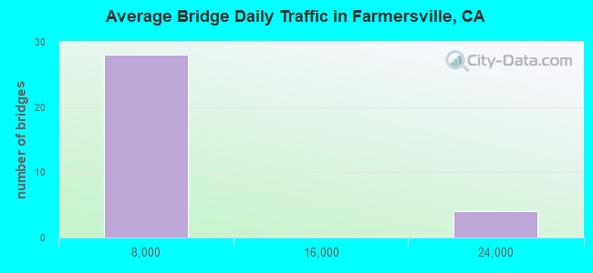
- 121,567Total average daily traffic
- 10,666Total average daily truck traffic
- National Bridge Inventory (NBI) Registered Bridges for Farmersville
- No street view available for this location
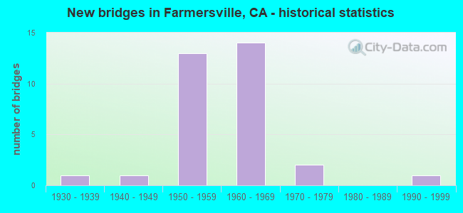
- New bridges - historical statistics
- 11930-1939
- 11940-1949
- 131950-1959
- 141960-1969
- 21970-1979
- 11990-1999
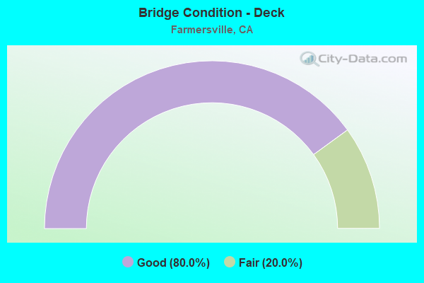
- Bridge Condition - Deck
- 80.0%Good
- 20.0%Fair
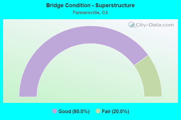
- Bridge Condition - Superstructure
- 80.0%Good
- 20.0%Fair
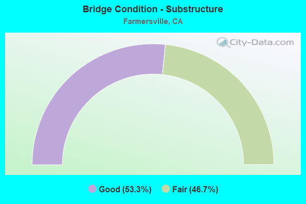
- Bridge Condition - Substructure
- 53.3%Good
- 46.7%Fair
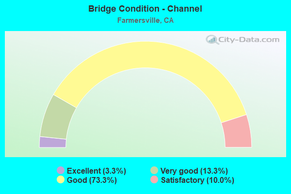
- Bridge Condition - Channel
- 3.3%Excellent
- 13.3%Very good
- 73.3%Good
- 10.0%Satisfactory
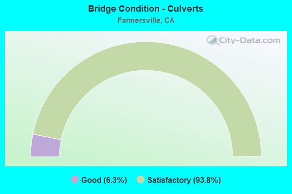
- Bridge Condition - Culverts
- 6.3%Good
- 93.8%Satisfactory
Find on map >> Show street view
Structure Number: 46 0016, Location: 06-TUL-198-R14.74 (Lat: 36.326589, Lng: -119.206956), Route carried "on" structure: State highway 198, Year Built: 1965, Status: Open, Structure Length: 0.79m (2.59ft), Average Daily Traffic: 20,000 (year 2009), Truck Traffic: 11%, Average Future Daily Traffic: 42,058 (year 2038), Design Load: HS 20+Mod, Features Intersected: TULARE CANAL
Minimum Vertical Clearance: 30+ m (98+ ft), Kilometerpoint: 14.740, Lanes on structure: 6, Base Highway Network: Yes (Inventory Route: 1, Subroute: 1), Owner: State Highway Agency, Approaching Roadway Width: 26.2m (86.0ft), Skew: 31 degrees, Material/Design: Concrete, Design/Construction: Culvert, Number Of Spans In Main Unit: 1, Length of Maximum Span: 7.3m (24.0ft), Curb-To-Curb Width: 43.9m (144.0ft), Out-to-Out Width: 44.8m (147.0ft)
Condition: Channel: Very good, Culverts: Satisfactory, Operating Rating: 54.1 metric tons, Method Used To Determine Operating Rating: Field evaluation and documented engineering judgment, Inventory Rating: 32.4 metric tons, Method Used To Determine Inventory Rating: Field evaluation and documented engineering judgment, Structural Evaluation: Equal to present minimum criteria, Deck Geometry: Superior to present desirable criteria, Waterway Adequacy: Equal to present desirable criteria, Approach Roadway Alignment: Equal to present desirable criteria, Designated Inspection Frequency: Every 48 months, Inspection Date: January 2021
Find on map >> Show street view
Structure Number: 46 0017, Location: 06-TUL-198-R16.00 (Lat: 36.326692, Lng: -119.184558), Route carried "on" structure: State highway 198, Year Built: 1951, Year Reconstructed: 1966, Status: Open, Structure Length: 1.68m (5.51ft), Average Daily Traffic: 20,000 (year 2009), Truck Traffic: 11%, Average Future Daily Traffic: 41,319 (year 2038), Design Load: HS 20, Features Intersected: DEEP CREEK
Minimum Vertical Clearance: 30+ m (98+ ft), Kilometerpoint: 16.000, Lanes on structure: 4, Base Highway Network: Yes (Inventory Route: 1, Subroute: 1), Owner: State Highway Agency, Approaching Roadway Width: 25.9m (85.0ft), Skew: 25 degrees, Material/Design: Concrete continuous, Design/Construction: Slab, Number Of Spans In Main Unit: 2, Length of Maximum Span: 7.9m (25.9ft), Curb-To-Curb Width: 25.9m (85.0ft), Out-to-Out Width: 26.7m (87.6ft)
Condition: Deck: Good, Superstructure: Good, Substructure: Fair, Channel: Good, Operating Rating: 50.9 metric tons, Method Used To Determine Operating Rating: Load Factor (LF), Inventory Rating: 30.5 metric tons, Method Used To Determine Inventory Rating: Load Factor (LF), Structural Evaluation: Somewhat better than minimum adequacy, Deck Geometry: Superior to present desirable criteria, Waterway Adequacy: Better than present minimum criteria, Approach Roadway Alignment: Equal to present desirable criteria, Designated Inspection Frequency: Every 24 months, Inspection Date: January 2021, Deck Structure Type: Concrete Cast-file-Place, Wearing Surface/Protective System: Wearing Surface: Bituminous
Find on map >> Show street view
Structure Number: 46 0023, Location: 06-TUL-198-R16.36 (Lat: 36.326575, Lng: -119.177864), Route carried "on" structure: State highway 198, Year Built: 1966, Status: Open, Structure Length: 0.70m (2.30ft), Average Daily Traffic: 20,000 (year 2009), Truck Traffic: 11%, Average Future Daily Traffic: 41,319 (year 2038), Design Load: HS 20+Mod, Features Intersected: JOHNSON SLOUGH
Minimum Vertical Clearance: 30+ m (98+ ft), Kilometerpoint: 16.360, Lanes on structure: 4, Base Highway Network: Yes (Inventory Route: 1, Subroute: 1), Owner: State Highway Agency, Approaching Roadway Width: 26.2m (86.0ft), Skew: 30 degrees, Material/Design: Concrete, Design/Construction: Culvert, Number Of Spans In Main Unit: 1, Length of Maximum Span: 6.4m (21.0ft), Curb-To-Curb Width: 26.4m (86.6ft), Out-to-Out Width: 26.8m (87.9ft)
Condition: Channel: Good, Culverts: Satisfactory, Operating Rating: 54.1 metric tons, Method Used To Determine Operating Rating: Field evaluation and documented engineering judgment, Inventory Rating: 32.4 metric tons, Method Used To Determine Inventory Rating: Field evaluation and documented engineering judgment, Structural Evaluation: Equal to present minimum criteria, Deck Geometry: Superior to present desirable criteria, Waterway Adequacy: Better than present minimum criteria, Approach Roadway Alignment: Equal to present desirable criteria, Designated Inspection Frequency: Every 48 months, Inspection Date: January 2021
Find on map >> Show street view
Structure Number: 46 0217, Location: 06-TUL-198-R14.65 (Lat: 36.327003, Lng: -119.208778), Route carried "on" structure: County highway W416, Year Built: 1966, Status: Open, Structure Length: 7.13m (23.39ft), Average Daily Traffic: 5,000 (year 2011), Truck Traffic: 15%, Average Future Daily Traffic: 8,782 (year 2041), Design Load: HS 20+Mod, Features Intersected: STATE ROUTE 198, Facility Carried by Structure: COUNTY ROAD 164
Minimum Vertical Clearance: 30+ m (98+ ft), Kilometerpoint: 0.000, Lanes on structure: 2, Lanes under structure: 6, Owner: State Highway Agency, Approaching Roadway Width: 12.2m (40.0ft), Material/Design: Steel, Design/Construction: Stringer/Multi-beam, Number Of Spans In Main Unit: 4, Length of Maximum Span: 25.0m (82.0ft), Curb or Sidewalk Widths: Left: 0.6m (2.0ft), Right: 1.5m (4.9ft), Curb-To-Curb Width: 8.5m (27.9ft), Out-to-Out Width: 11.3m (37.1ft)
Condition: Deck: Good, Superstructure: Good, Substructure: Good, Operating Rating: 37.3 metric tons, Method Used To Determine Operating Rating: Load and Resistance Factor Rating (LRFR) rating reported by rating factor(RF) method using HL-93 loadings, Inventory Rating: 28.8 metric tons, Method Used To Determine Inventory Rating: Load and Resistance Factor Rating (LRFR) rating reported by rating factor(RF) method using HL-93 loadings, Structural Evaluation: Better than present minimum criteria, Deck Geometry: Meets minimum limits, Underclear: Equal to present minimum criteria, Approach Roadway Alignment: Equal to present minimum criteria, Designated Inspection Frequency: Every 24 months, Critical Feature Inspection Frequency: Every 24 months, Inspection Date: January 2021, Critical Feature Inspection Date: December 2020, Deck Structure Type: Concrete Cast-file-Place
Find on map >> Show street view
Structure Number: 46C0015, Location: 0.2 MI E OF RD 164 (Lat: 36.327644, Lng: -119.206533), Route carried "on" structure: County highway , Year Built: 1965, Status: Open, Structure Length: 0.76m (2.49ft), Average Daily Traffic: 800 (year 1978), Truck Traffic: 2%, Average Future Daily Traffic: 1,073 (year 2036), Design Load: HS 20, Features Intersected: TULARE IRRIG DIST CANAL, Facility Carried by Structure: AVE 296
Minimum Vertical Clearance: 30+ m (98+ ft), Kilometerpoint: 0.000, Lanes on structure: 2, Owner: County Highway Agency, Approaching Roadway Width: 7.3m (24.0ft), Material/Design: Concrete, Design/Construction: Culvert, Number Of Spans In Main Unit: 1, Length of Maximum Span: 7.0m (23.0ft), Curb or Sidewalk Widths: Left: 0.6m (2.0ft), Right: 0.6m (2.0ft), Curb-To-Curb Width: 12.2m (40.0ft), Out-to-Out Width: 14.0m (45.9ft)
Condition: Channel: Good, Culverts: Satisfactory, Operating Rating: 54.1 metric tons, Method Used To Determine Operating Rating: Field evaluation and documented engineering judgment, Inventory Rating: 32.4 metric tons, Method Used To Determine Inventory Rating: Field evaluation and documented engineering judgment, Structural Evaluation: Equal to present minimum criteria, Deck Geometry: Equal to present desirable criteria, Waterway Adequacy: Equal to present desirable criteria, Approach Roadway Alignment: Equal to present desirable criteria, Designated Inspection Frequency: Every 48 months, Inspection Date: March 2018, Wearing Surface/Protective System: Wearing Surface: Bituminous
Find on map >> Show street view
Structure Number: 46C002, Location: 0.1 MI S OF S.R. 198 (Lat: 36.325119, Lng: -119.207406), Route carried "on" structure: County highway , Year Built: 1965, Status: Open, Structure Length: 0.74m (2.43ft), Average Daily Traffic: 7,781 (year 2011), Truck Traffic: 2%, Average Future Daily Traffic: 4,601 (year 2044), Design Load: HS 20, Features Intersected: TULARE IRRIG DIST CANAL, Facility Carried by Structure: ROAD 164
Minimum Vertical Clearance: 30+ m (98+ ft), Kilometerpoint: 0.000, Lanes on structure: 2, Owner: County Highway Agency, Approaching Roadway Width: 12.2m (40.0ft), Skew: 1 degrees, Material/Design: Concrete, Design/Construction: Culvert, Number Of Spans In Main Unit: 1, Length of Maximum Span: 7.4m (24.3ft), Curb-To-Curb Width: 12.2m (40.0ft), Out-to-Out Width: 19.2m (63.0ft)
Condition: Channel: Good, Culverts: Satisfactory, Operating Rating: 54.1 metric tons, Method Used To Determine Operating Rating: Field evaluation and documented engineering judgment, Inventory Rating: 32.4 metric tons, Method Used To Determine Inventory Rating: Field evaluation and documented engineering judgment, Structural Evaluation: Equal to present minimum criteria, Deck Geometry: Somewhat better than minimum adequacy, Waterway Adequacy: Better than present minimum criteria, Approach Roadway Alignment: Equal to present desirable criteria, Designated Inspection Frequency: Every 48 months, Inspection Date: January 2022
Find on map >> Show street view
Structure Number: 46C0034, Location: 0.1 MI S OF AVE 308 (Lat: 36.346431, Lng: -119.197861), Route carried "on" structure: County highway , Year Built: 1954, Status: Open, Structure Length: 3.41m (11.19ft), Average Daily Traffic: 1,000 (year 1978), Truck Traffic: 5%, Average Future Daily Traffic: 1,313 (year 2042), Design Load: HS 20, Features Intersected: KAWEAH RIVER, Facility Carried by Structure: ROAD 168
Minimum Vertical Clearance: 30+ m (98+ ft), Kilometerpoint: 0.000, Lanes on structure: 2, Owner: County Highway Agency, Approaching Roadway Width: 7.0m (23.0ft), Skew: 4 degrees, Material/Design: Concrete continuous, Design/Construction: Slab, Number Of Spans In Main Unit: 5, Length of Maximum Span: 7.3m (24.0ft), Curb or Sidewalk Widths: Left: 0.3m (1.0ft), Right: 0.3m (1.0ft), Curb-To-Curb Width: 7.9m (25.9ft), Out-to-Out Width: 8.5m (27.9ft)
Condition: Deck: Good, Superstructure: Good, Substructure: Fair, Channel: Good, Operating Rating: 55.7 metric tons, Method Used To Determine Operating Rating: Load Factor (LF), Inventory Rating: 33.4 metric tons, Method Used To Determine Inventory Rating: Load Factor (LF), Structural Evaluation: Somewhat better than minimum adequacy, Deck Geometry: Somewhat better than minimum adequacy, Waterway Adequacy: Equal to present desirable criteria, Approach Roadway Alignment: Equal to present desirable criteria, Designated Inspection Frequency: Every 24 months, Inspection Date: December 2020, Deck Structure Type: Concrete Cast-file-Place, Wearing Surface/Protective System: Wearing Surface: Bituminous
Find on map >> Show street view
Structure Number: 46C0035, Location: 0.25 MI E OF RD 156 (Lat: 36.297878, Lng: -119.220683), Route carried "on" structure: County highway , Year Built: 1954, Status: Open, Structure Length: 1.91m (6.27ft), Average Daily Traffic: 3,140 (year 1971), Truck Traffic: 5%, Average Future Daily Traffic: 5,561 (year 2042), Design Load: HS 20, Features Intersected: TULARE IRRIG DIST CANAL, Facility Carried by Structure: AVE 280
Minimum Vertical Clearance: 30+ m (98+ ft), Kilometerpoint: 0.000, Lanes on structure: 2, Owner: County Highway Agency, Approaching Roadway Width: 8.8m (28.9ft), Material/Design: Concrete continuous, Design/Construction: Slab, Number Of Spans In Main Unit: 3, Length of Maximum Span: 7.3m (24.0ft), Curb or Sidewalk Widths: Left: 0.3m (1.0ft), Right: 0.3m (1.0ft), Curb-To-Curb Width: 11.0m (36.1ft), Out-to-Out Width: 11.6m (38.1ft)
Condition: Deck: Good, Superstructure: Good, Substructure: Fair, Channel: Good, Operating Rating: 55.1 metric tons, Method Used To Determine Operating Rating: Load Factor (LF), Inventory Rating: 33.4 metric tons, Method Used To Determine Inventory Rating: Load Factor (LF), Structural Evaluation: Somewhat better than minimum adequacy, Deck Geometry: Somewhat better than minimum adequacy, Waterway Adequacy: Equal to present desirable criteria, Approach Roadway Alignment: Equal to present desirable criteria, Designated Inspection Frequency: Every 24 months, Inspection Date: January 2022, Deck Structure Type: Concrete Cast-file-Place, Wearing Surface/Protective System: Wearing Surface: Bituminous
Find on map >> Show street view
Structure Number: 46C0036, Location: 0.1 MI N OF SR 198 (Lat: 36.329839, Lng: -119.197819), Route carried "on" structure: County highway , Year Built: 1954, Status: Open, Structure Length: 1.92m (6.30ft), Average Daily Traffic: 720 (year 2010), Truck Traffic: 10%, Average Future Daily Traffic: 1,059 (year 2036), Design Load: HS 20, Features Intersected: TULARE IRRIG DIST CANAL, Facility Carried by Structure: ROAD 168
Minimum Vertical Clearance: 30+ m (98+ ft), Kilometerpoint: 0.000, Lanes on structure: 2, Owner: County Highway Agency, Approaching Roadway Width: 7.6m (24.9ft), Material/Design: Concrete continuous, Design/Construction: Slab, Number Of Spans In Main Unit: 3, Length of Maximum Span: 7.3m (24.0ft), Curb or Sidewalk Widths: Left: 0.4m (1.3ft), Right: 0.4m (1.3ft), Curb-To-Curb Width: 11.0m (36.1ft), Out-to-Out Width: 11.7m (38.4ft)
Condition: Deck: Good, Superstructure: Good, Substructure: Good, Channel: Very good, Operating Rating: 52.8 metric tons, Method Used To Determine Operating Rating: Load Factor (LF), Inventory Rating: 32.1 metric tons, Method Used To Determine Inventory Rating: Load Factor (LF), Structural Evaluation: Better than present minimum criteria, Deck Geometry: Better than present minimum criteria, Waterway Adequacy: Equal to present desirable criteria, Approach Roadway Alignment: Equal to present desirable criteria, Designated Inspection Frequency: Every 48 months, Inspection Date: December 2018, Deck Structure Type: Concrete Cast-file-Place, Wearing Surface/Protective System: Wearing Surface: Bituminous
Find on map >> Show street view
Structure Number: 46C0041, Location: 0.75 MI W OF RD 180 (Lat: 36.297733, Lng: -119.186117), Route carried "on" structure: County highway , Year Built: 1965, Status: Open, Structure Length: 1.28m (4.20ft), Average Daily Traffic: 3,200 (year 1971), Truck Traffic: 10%, Average Future Daily Traffic: 5,561 (year 2044), Design Load: HS 20, Features Intersected: OUTSIDE CREEK, Facility Carried by Structure: AVE 280(VISALIA RD
Minimum Vertical Clearance: 30+ m (98+ ft), Kilometerpoint: 0.000, Lanes on structure: 2, Owner: County Highway Agency, Approaching Roadway Width: 9.4m (30.8ft), Material/Design: Concrete continuous, Design/Construction: Slab, Number Of Spans In Main Unit: 2, Length of Maximum Span: 6.1m (20.0ft), Curb-To-Curb Width: 19.5m (64.0ft), Out-to-Out Width: 19.7m (64.6ft)
Condition: Deck: Good, Superstructure: Good, Substructure: Good, Channel: Good, Operating Rating: 53.1 metric tons, Method Used To Determine Operating Rating: Load Factor (LF), Inventory Rating: 32.1 metric tons, Method Used To Determine Inventory Rating: Load Factor (LF), Structural Evaluation: Better than present minimum criteria, Deck Geometry: Superior to present desirable criteria, Waterway Adequacy: Equal to present desirable criteria, Approach Roadway Alignment: Equal to present desirable criteria, Designated Inspection Frequency: Every 48 months, Inspection Date: January 2022, Deck Structure Type: Concrete Cast-file-Place, Wearing Surface/Protective System: Wearing Surface: Bituminous
Find on map >> Show street view
Structure Number: 46C006, Location: 1.15 MI S OF AVE 352 (Lat: 36.414706, Lng: -119.463658), Route carried "on" structure: County highway , Year Built: 1962, Status: Open, Structure Length: 1.80m (5.91ft), Average Daily Traffic: 225 (year 1978), Truck Traffic: 5%, Average Future Daily Traffic: 377 (year 2042), Design Load: HS 20, Features Intersected: CROSS CREEK, Facility Carried by Structure: D 60
Minimum Vertical Clearance: 30+ m (98+ ft), Kilometerpoint: 0.000, Lanes on structure: 2, Owner: County Highway Agency, Approaching Roadway Width: 9.1m (29.9ft), Skew: 3 degrees, Material/Design: Concrete continuous, Design/Construction: Slab, Number Of Spans In Main Unit: 2, Length of Maximum Span: 8.5m (27.9ft), Curb-To-Curb Width: 9.1m (29.9ft), Out-to-Out Width: 9.4m (30.8ft)
Condition: Deck: Good, Superstructure: Good, Substructure: Good, Channel: Good, Operating Rating: 40.8 metric tons, Method Used To Determine Operating Rating: Load Factor (LF), Inventory Rating: 24.6 metric tons, Method Used To Determine Inventory Rating: Load Factor (LF), Structural Evaluation: Equal to present minimum criteria, Deck Geometry: Equal to present minimum criteria, Waterway Adequacy: Equal to present desirable criteria, Approach Roadway Alignment: Equal to present desirable criteria, Designated Inspection Frequency: Every 24 months, Inspection Date: December 2021, Deck Structure Type: Concrete Cast-file-Place, Wearing Surface/Protective System: Wearing Surface: Bituminous
Find on map >> Show street view
Structure Number: 46C0066, Location: 0.5 MI W OF RD 180 (Lat: 36.326419, Lng: -119.177839), Route carried "on" structure: County highway , Year Built: 1966, Status: Open, Structure Length: 0.70m (2.30ft), Average Daily Traffic: 25 (year 1978), Average Future Daily Traffic: 56 (year 2044), Design Load: HS 20, Features Intersected: JOHNSON SLOUGH, Facility Carried by Structure: AVE 295
Minimum Vertical Clearance: 30+ m (98+ ft), Kilometerpoint: 0.000, Lanes on structure: 2, Owner: County Highway Agency, Approaching Roadway Width: 7.3m (24.0ft), Material/Design: Concrete, Design/Construction: Culvert, Number Of Spans In Main Unit: 1, Length of Maximum Span: 6.4m (21.0ft), Curb or Sidewalk Widths: Left: 0.0m, Right: 0.6m (2.0ft), Curb-To-Curb Width: 9.9m (32.5ft), Out-to-Out Width: 11.1m (36.4ft)
Condition: Channel: Good, Culverts: Good, Operating Rating: 54.1 metric tons, Method Used To Determine Operating Rating: Field evaluation and documented engineering judgment, Inventory Rating: 32.4 metric tons, Method Used To Determine Inventory Rating: Field evaluation and documented engineering judgment, Structural Evaluation: Better than present minimum criteria, Deck Geometry: Superior to present desirable criteria, Waterway Adequacy: Equal to present desirable criteria, Approach Roadway Alignment: Equal to present desirable criteria, Designated Inspection Frequency: Every 48 months, Inspection Date: January 2022, Deck Structure Type: Concrete Cast-file-Place, Wearing Surface/Protective System: Wearing Surface: Bituminous
Find on map >> Show street view
Structure Number: 46C0068, Location: BTWN LARRY ST & COSTNR ST (Lat: 36.299583, Lng: -119.200753), Route carried "on" structure: City street , Year Built: 1963, Status: Open, Structure Length: 1.40m (4.59ft), Average Daily Traffic: 1,572 (year 2011), Truck Traffic: 5%, Average Future Daily Traffic: 984 (year 2042), Design Load: HS 20, Features Intersected: DEEP CREEK, Facility Carried by Structure: HESTER AVE
Minimum Vertical Clearance: 30+ m (98+ ft), Kilometerpoint: 0.000, Lanes on structure: 2, Owner: City or Municipal Highway Agency, Approaching Roadway Width: 12.2m (40.0ft), Skew: 2 degrees, Material/Design: Concrete continuous, Design/Construction: Slab, Number Of Spans In Main Unit: 2, Length of Maximum Span: 6.7m (22.0ft), Curb or Sidewalk Widths: Left: 1.3m (4.3ft), Right: 1.3m (4.3ft), Curb-To-Curb Width: 8.2m (26.9ft), Out-to-Out Width: 10.8m (35.4ft)
Condition: Deck: Fair, Superstructure: Fair, Substructure: Fair, Channel: Excellent, Operating Rating: 48.9 metric tons, Method Used To Determine Operating Rating: Load Factor (LF), Inventory Rating: 29.5 metric tons, Method Used To Determine Inventory Rating: Load Factor (LF), Structural Evaluation: Somewhat better than minimum adequacy, Deck Geometry: Meets minimum limits, Waterway Adequacy: Equal to present desirable criteria, Approach Roadway Alignment: Equal to present desirable criteria, Designated Inspection Frequency: Every 24 months, Inspection Date: January 2022, Deck Structure Type: Concrete Cast-file-Place
Find on map >> Show street view
Structure Number: 46C0112, Location: 0.7 MI W OF RD 180 (Lat: 36.312053, Lng: -119.183794), Route carried "on" structure: County highway , Year Built: 1975, Status: Open, Structure Length: 1.01m (3.31ft), Average Daily Traffic: 750 (year 1978), Truck Traffic: 5%, Average Future Daily Traffic: 1,095 (year 2042), Features Intersected: OUTSIDE CREEK, Facility Carried by Structure: AVE 288
Minimum Vertical Clearance: 30+ m (98+ ft), Kilometerpoint: 0.000, Lanes on structure: 2, Owner: County Highway Agency, Approaching Roadway Width: 7.3m (24.0ft), Material/Design: Concrete continuous, Design/Construction: Culvert, Number Of Spans In Main Unit: 3, Length of Maximum Span: 3.0m (9.8ft), Curb-To-Curb Width: 12.2m (40.0ft), Out-to-Out Width: 12.8m (42.0ft)
Condition: Channel: Very good, Culverts: Satisfactory, Operating Rating: 54.1 metric tons, Method Used To Determine Operating Rating: Field evaluation and documented engineering judgment, Inventory Rating: 32.4 metric tons, Method Used To Determine Inventory Rating: Field evaluation and documented engineering judgment, Structural Evaluation: Equal to present minimum criteria, Deck Geometry: Equal to present desirable criteria, Waterway Adequacy: Superior to present desirable criteria, Approach Roadway Alignment: Equal to present desirable criteria, Designated Inspection Frequency: Every 48 months, Inspection Date: January 2022, Deck Structure Type: Concrete Cast-file-Place, Wearing Surface/Protective System: Wearing Surface: Bituminous
Find on map >> Show street view
Structure Number: 46C0113, Location: 0.5 MI N OF AVE 304 (Lat: 36.349700, Lng: -119.171136), Route carried "on" structure: County highway , Year Built: 1990, Status: Open, Structure Length: 3.96m (12.99ft), Average Daily Traffic: 380 (year 1986), Truck Traffic: 2%, Average Future Daily Traffic: 1,006 (year 2042), Design Load: HS 20, Features Intersected: KAWEAH RIVER, Facility Carried by Structure: ROAD 180
Minimum Vertical Clearance: 30+ m (98+ ft), Kilometerpoint: 0.000, Lanes on structure: 2, Owner: County Highway Agency, Approaching Roadway Width: 6.4m (21.0ft), Skew: 1 degrees, Material/Design: Concrete continuous, Design/Construction: Slab, Number Of Spans In Main Unit: 5, Length of Maximum Span: 7.9m (25.9ft), Curb-To-Curb Width: 9.8m (32.2ft), Out-to-Out Width: 10.6m (34.8ft)
Condition: Deck: Good, Superstructure: Good, Substructure: Good, Channel: Good, Operating Rating: 54.1 metric tons, Method Used To Determine Operating Rating: Assigned rating based on Load Factor Design (LFD) reported in metric tons, Inventory Rating: 32.4 metric tons, Method Used To Determine Inventory Rating: Assigned rating based on Load Factor Design (LFD) reported in metric tons, Structural Evaluation: Better than present minimum criteria, Deck Geometry: Better than present minimum criteria, Waterway Adequacy: Superior to present desirable criteria, Approach Roadway Alignment: Equal to present desirable criteria, Designated Inspection Frequency: Every 48 months, Inspection Date: December 2020, Deck Structure Type: Concrete Cast-file-Place
Find on map >> Show street view
Structure Number: 46C0152, Location: 0.15 MI S OF AVE 280 (Lat: 36.294953, Lng: -119.207119), Route carried "on" structure: City street , Year Built: 1956, Status: Open, Structure Length: 1.40m (4.59ft), Average Daily Traffic: 4,088 (year 2011), Truck Traffic: 2%, Average Future Daily Traffic: 1,937 (year 2042), Features Intersected: DEEP CREEK, Facility Carried by Structure: RD 164 (FRMSVL BL)
Minimum Vertical Clearance: 30+ m (98+ ft), Kilometerpoint: 0.000, Lanes on structure: 3, Owner: City or Municipal Highway Agency, Approaching Roadway Width: 16.2m (53.1ft), Skew: 4 degrees, Material/Design: Concrete continuous, Design/Construction: Culvert, Number Of Spans In Main Unit: 3, Length of Maximum Span: 4.6m (15.1ft), Curb or Sidewalk Widths: Left: 1.0m (3.3ft), Right: 2.5m (8.2ft), Curb-To-Curb Width: 23.8m (78.1ft), Out-to-Out Width: 34.5m (113.2ft)
Condition: Channel: Good, Culverts: Satisfactory, Operating Rating: 40.5 metric tons, Method Used To Determine Operating Rating: Field evaluation and documented engineering judgment, Inventory Rating: 24.3 metric tons, Method Used To Determine Inventory Rating: Field evaluation and documented engineering judgment, Structural Evaluation: Equal to present minimum criteria, Deck Geometry: Superior to present desirable criteria, Waterway Adequacy: Equal to present desirable criteria, Approach Roadway Alignment: Equal to present desirable criteria, Designated Inspection Frequency: Every 24 months, Inspection Date: January 2022, Deck Structure Type: Concrete Cast-file-Place, Wearing Surface/Protective System: Wearing Surface: Bituminous
Find on map >> Show street view
Structure Number: 46C0377, Location: 0.5 MI W OF RD 168 (Lat: 36.225289, Lng: -119.209325), Route carried "on" structure: County highway , Year Built: 1951, Status: Open, Structure Length: 0.70m (2.30ft), Average Daily Traffic: 300 (year 1978), Truck Traffic: 5%, Average Future Daily Traffic: 564 (year 2043), Features Intersected: OUTSIDE CREEK, Facility Carried by Structure: AVE 240
Minimum Vertical Clearance: 30+ m (98+ ft), Kilometerpoint: 0.000, Lanes on structure: 2, Owner: County Highway Agency, Approaching Roadway Width: 5.5m (18.0ft), Material/Design: Concrete continuous, Design/Construction: Culvert, Number Of Spans In Main Unit: 2, Length of Maximum Span: 3.0m (9.8ft), Curb or Sidewalk Widths: Left: 0.3m (1.0ft), Right: 0.3m (1.0ft), Curb-To-Curb Width: 7.9m (25.9ft), Out-to-Out Width: 8.5m (27.9ft)
Condition: Channel: Satisfactory, Culverts: Satisfactory, Operating Rating: 54.4 metric tons, Method Used To Determine Operating Rating: Load Factor (LF), Inventory Rating: 32.7 metric tons, Method Used To Determine Inventory Rating: Load Factor (LF), Structural Evaluation: Equal to present minimum criteria, Deck Geometry: Somewhat better than minimum adequacy, Waterway Adequacy: Superior to present desirable criteria, Approach Roadway Alignment: Equal to present desirable criteria, Designated Inspection Frequency: Every 48 months, Inspection Date: November 2021, Deck Structure Type: Concrete Cast-file-Place, Wearing Surface/Protective System: Wearing Surface: Bituminous
Find on map >> Show street view
Structure Number: 46C0378, Location: 0.6 MI W OF RD 168 (Lat: 36.225236, Lng: -119.209039), Route carried "on" structure: County highway , Year Built: 1951, Status: Open, Structure Length: 1.22m (4.00ft), Average Daily Traffic: 300 (year 2010), Truck Traffic: 10%, Average Future Daily Traffic: 546 (year 2041), Features Intersected: INSIDE CREEK, Facility Carried by Structure: AVE 240
Minimum Vertical Clearance: 30+ m (98+ ft), Kilometerpoint: 0.000, Lanes on structure: 2, Owner: County Highway Agency, Approaching Roadway Width: 5.5m (18.0ft), Skew: 4 degrees, Material/Design: Concrete continuous, Design/Construction: Culvert, Number Of Spans In Main Unit: 3, Length of Maximum Span: 3.7m (12.1ft), Curb or Sidewalk Widths: Left: 0.3m (1.0ft), Right: 0.3m (1.0ft), Curb-To-Curb Width: 7.9m (25.9ft), Out-to-Out Width: 8.5m (27.9ft)
Condition: Channel: Satisfactory, Culverts: Satisfactory, Operating Rating: 37.6 metric tons, Method Used To Determine Operating Rating: Load Factor (LF), Inventory Rating: 22.7 metric tons, Method Used To Determine Inventory Rating: Load Factor (LF), Structural Evaluation: Equal to present minimum criteria, Deck Geometry: Somewhat better than minimum adequacy, Waterway Adequacy: Superior to present desirable criteria, Approach Roadway Alignment: Equal to present desirable criteria, Designated Inspection Frequency: Every 24 months, Inspection Date: November 2021, Deck Structure Type: Concrete Cast-file-Place, Wearing Surface/Protective System: Wearing Surface: Bituminous
Find on map >> Show street view
Structure Number: 46C0386, Location: 0.1 MI S OF AVE 264 (Lat: 36.267697, Lng: -119.242889), Route carried "on" structure: County highway , Year Built: 1946, Status: Open, Structure Length: 0.73m (2.40ft), Average Daily Traffic: 75 (year 1978), Average Future Daily Traffic: 99 (year 2042), Features Intersected: DEEP CREEK, Facility Carried by Structure: ROAD 148
Minimum Vertical Clearance: 30+ m (98+ ft), Kilometerpoint: 0.000, Lanes on structure: 2, Owner: County Highway Agency, Approaching Roadway Width: 5.5m (18.0ft), Material/Design: Concrete continuous, Design/Construction: Slab, Number Of Spans In Main Unit: 2, Length of Maximum Span: 3.4m (11.2ft), Curb-To-Curb Width: 7.1m (23.3ft), Out-to-Out Width: 7.3m (24.0ft)
Condition: Deck: Good, Superstructure: Good, Substructure: Good, Channel: Good, Operating Rating: 26.9 metric tons, Method Used To Determine Operating Rating: Field evaluation and documented engineering judgment, Inventory Rating: 16.2 metric tons, Method Used To Determine Inventory Rating: Field evaluation and documented engineering judgment, Structural Evaluation: Somewhat better than minimum adequacy, Deck Geometry: Somewhat better than minimum adequacy, Waterway Adequacy: Equal to present desirable criteria, Approach Roadway Alignment: Better than present minimum criteria, Designated Inspection Frequency: Every 24 months, Inspection Date: January 2022, Deck Structure Type: Concrete Cast-file-Place
Find on map >> Show street view
Structure Number: 46C0387, Location: 0.5 MI E OF RD 164 (Lat: 36.268736, Lng: -119.197508), Route carried "on" structure: County highway , Year Built: 1969, Status: Open, Structure Length: 1.07m (3.51ft), Average Daily Traffic: 300 (year 1978), Truck Traffic: 5%, Average Future Daily Traffic: 438 (year 2042), Features Intersected: OUTSIDE CREEK, Facility Carried by Structure: AVE 264
Minimum Vertical Clearance: 30+ m (98+ ft), Kilometerpoint: 0.000, Lanes on structure: 2, Owner: County Highway Agency, Approaching Roadway Width: 9.8m (32.2ft), Skew: 2 degrees, Material/Design: Concrete continuous, Design/Construction: Culvert, Number Of Spans In Main Unit: 3, Length of Maximum Span: 3.2m (10.5ft), Curb-To-Curb Width: 9.8m (32.2ft), Out-to-Out Width: 10.2m (33.5ft)
Condition: Channel: Good, Culverts: Satisfactory, Operating Rating: 34.0 metric tons, Method Used To Determine Operating Rating: Load Factor (LF), Inventory Rating: 20.4 metric tons, Method Used To Determine Inventory Rating: Load Factor (LF), Structural Evaluation: Somewhat better than minimum adequacy, Deck Geometry: Better than present minimum criteria, Waterway Adequacy: Equal to present desirable criteria, Approach Roadway Alignment: Equal to present desirable criteria, Designated Inspection Frequency: Every 24 months, Inspection Date: January 2022, Deck Structure Type: Concrete Cast-file-Place, Wearing Surface/Protective System: Wearing Surface: Bituminous
Find on map >> Show street view
Structure Number: 46C0388, Location: 1.4 MI S OF AVE 280 (Lat: 36.276228, Lng: -119.225008), Route carried "on" structure: County highway , Year Built: 1959, Status: Open, Structure Length: 0.87m (2.85ft), Average Daily Traffic: 425 (year 1978), Truck Traffic: 5%, Average Future Daily Traffic: 657 (year 2042), Features Intersected: DEEP CREEK, Facility Carried by Structure: RD 156
Minimum Vertical Clearance: 30+ m (98+ ft), Kilometerpoint: 0.000, Lanes on structure: 2, Owner: County Highway Agency, Approaching Roadway Width: 7.3m (24.0ft), Material/Design: Concrete, Design/Construction: Slab, Number Of Spans In Main Unit: 1, Length of Maximum Span: 7.9m (25.9ft), Curb-To-Curb Width: 8.5m (27.9ft), Out-to-Out Width: 8.5m (27.9ft)
Condition: Deck: Good, Superstructure: Good, Substructure: Good, Channel: Good, Operating Rating: 50.5 metric tons, Method Used To Determine Operating Rating: Load Factor (LF), Inventory Rating: 30.5 metric tons, Method Used To Determine Inventory Rating: Load Factor (LF), Structural Evaluation: Better than present minimum criteria, Deck Geometry: Somewhat better than minimum adequacy, Waterway Adequacy: Equal to present desirable criteria, Approach Roadway Alignment: Equal to present desirable criteria, Designated Inspection Frequency: Every 24 months, Inspection Date: January 2022, Deck Structure Type: Concrete Cast-file-Place, Wearing Surface/Protective System: Wearing Surface: Bituminous
Find on map >> Show street view
Structure Number: 46C0389, Location: 0.5 MI S OF AVE 280 (Lat: 36.290614, Lng: -119.224983), Route carried "on" structure: County highway , Year Built: 1970, Status: Open, Structure Length: 0.79m (2.59ft), Average Daily Traffic: 425 (year 1978), Truck Traffic: 5%, Average Future Daily Traffic: 679 (year 2044), Design Load: HS 20, Features Intersected: TULARE IRRIG DIST CANAL, Facility Carried by Structure: ROAD 156
Minimum Vertical Clearance: 30+ m (98+ ft), Kilometerpoint: 0.000, Lanes on structure: 2, Owner: County Highway Agency, Approaching Roadway Width: 7.3m (24.0ft), Material/Design: Concrete continuous, Design/Construction: Culvert, Number Of Spans In Main Unit: 2, Length of Maximum Span: 3.7m (12.1ft), Curb-To-Curb Width: 12.2m (40.0ft), Out-to-Out Width: 12.7m (41.7ft)
Condition: Channel: Good, Culverts: Satisfactory, Operating Rating: 54.1 metric tons, Method Used To Determine Operating Rating: Field evaluation and documented engineering judgment, Inventory Rating: 32.4 metric tons, Method Used To Determine Inventory Rating: Field evaluation and documented engineering judgment, Structural Evaluation: Equal to present minimum criteria, Deck Geometry: Equal to present desirable criteria, Waterway Adequacy: Equal to present desirable criteria, Approach Roadway Alignment: Equal to present desirable criteria, Designated Inspection Frequency: Every 48 months, Inspection Date: January 2022, Deck Structure Type: Concrete Cast-file-Place, Wearing Surface/Protective System: Wearing Surface: Bituminous
Find on map >> Show street view
Structure Number: 46C0395, Location: 0.5 MI W OF RD 164 (Lat: 36.268850, Lng: -119.215972), Route carried "on" structure: County highway , Year Built: 1954, Status: Open, Structure Length: 0.67m (2.20ft), Average Daily Traffic: 300 (year 1978), Truck Traffic: 5%, Average Future Daily Traffic: 438 (year 2042), Features Intersected: FARMERS DITCH, Facility Carried by Structure: AVE 264
Minimum Vertical Clearance: 30+ m (98+ ft), Kilometerpoint: 0.000, Lanes on structure: 2, Owner: County Highway Agency, Approaching Roadway Width: 7.9m (25.9ft), Material/Design: Concrete continuous, Design/Construction: Culvert, Number Of Spans In Main Unit: 2, Length of Maximum Span: 3.0m (9.8ft), Curb-To-Curb Width: 7.9m (25.9ft), Out-to-Out Width: 8.4m (27.6ft)
Condition: Channel: Very good, Culverts: Satisfactory, Operating Rating: 40.5 metric tons, Method Used To Determine Operating Rating: Field evaluation and documented engineering judgment, Inventory Rating: 24.3 metric tons, Method Used To Determine Inventory Rating: Field evaluation and documented engineering judgment, Structural Evaluation: Equal to present minimum criteria, Deck Geometry: Somewhat better than minimum adequacy, Waterway Adequacy: Equal to present desirable criteria, Approach Roadway Alignment: Equal to present desirable criteria, Designated Inspection Frequency: Every 24 months, Inspection Date: January 2022, Deck Structure Type: Concrete Cast-file-Place, Wearing Surface/Protective System: Wearing Surface: Bituminous
Find on map >> Show street view
Structure Number: 46C0396, Location: 0.1 MI E OF RD 168 (Lat: 36.312175, Lng: -119.196786), Route carried "on" structure: County highway , Year Built: 1951, Status: Open, Structure Length: 1.74m (5.71ft), Average Daily Traffic: 750 (year 1978), Truck Traffic: 10%, Average Future Daily Traffic: 984 (year 2042), Features Intersected: DEEP CREEK, Facility Carried by Structure: AVE 288
Minimum Vertical Clearance: 30+ m (98+ ft), Kilometerpoint: 0.000, Lanes on structure: 2, Owner: County Highway Agency, Approaching Roadway Width: 7.3m (24.0ft), Material/Design: Concrete continuous, Design/Construction: Slab, Number Of Spans In Main Unit: 3, Length of Maximum Span: 6.7m (22.0ft), Curb or Sidewalk Widths: Left: 0.3m (1.0ft), Right: 0.3m (1.0ft), Curb-To-Curb Width: 7.9m (25.9ft), Out-to-Out Width: 8.5m (27.9ft)
Condition: Deck: Good, Superstructure: Good, Substructure: Fair, Channel: Good, Operating Rating: 64.8 metric tons, Method Used To Determine Operating Rating: Load Factor (LF), Inventory Rating: 38.9 metric tons, Method Used To Determine Inventory Rating: Load Factor (LF), Structural Evaluation: Somewhat better than minimum adequacy, Deck Geometry: Somewhat better than minimum adequacy, Waterway Adequacy: Equal to present desirable criteria, Approach Roadway Alignment: Equal to present desirable criteria, Designated Inspection Frequency: Every 24 months, Inspection Date: January 2022, Deck Structure Type: Concrete Cast-file-Place, Wearing Surface/Protective System: Wearing Surface: Bituminous
Find on map >> Show street view
Structure Number: 46C04, Location: 0.1 MI S OF AVE 312 (Lat: 36.353833, Lng: -119.171203), Route carried "on" structure: County highway , Year Built: 1954, Status: Open, Structure Length: 0.79m (2.59ft), Average Daily Traffic: 550 (year 1978), Truck Traffic: 5%, Average Future Daily Traffic: 548 (year 2042), Features Intersected: PACKWOOD CREEK, Facility Carried by Structure: ROAD 180
Minimum Vertical Clearance: 30+ m (98+ ft), Kilometerpoint: 0.000, Lanes on structure: 2, Owner: County Highway Agency, Approaching Roadway Width: 7.3m (24.0ft), Skew: 3 degrees, Material/Design: Concrete continuous, Design/Construction: Culvert, Number Of Spans In Main Unit: 2, Length of Maximum Span: 3.7m (12.1ft), Curb-To-Curb Width: 7.9m (25.9ft), Out-to-Out Width: 8.3m (27.2ft)
Condition: Channel: Good, Culverts: Satisfactory, Operating Rating: 68.7 metric tons, Method Used To Determine Operating Rating: Load Factor (LF), Inventory Rating: 41.5 metric tons, Method Used To Determine Inventory Rating: Load Factor (LF), Structural Evaluation: Equal to present minimum criteria, Deck Geometry: Somewhat better than minimum adequacy, Waterway Adequacy: Equal to present desirable criteria, Approach Roadway Alignment: Equal to present desirable criteria, Designated Inspection Frequency: Every 48 months, Inspection Date: December 2020, Deck Structure Type: Concrete Cast-file-Place, Wearing Surface/Protective System: Wearing Surface: Bituminous
Find on map >> Show street view
Structure Number: 46C0402, Location: 0.5 MI W OF RD 180 (Lat: 36.341258, Lng: -119.179922), Route carried "on" structure: County highway , Year Built: 1950, Status: Open, Structure Length: 0.91m (2.99ft), Average Daily Traffic: 900 (year 1978), Truck Traffic: 5%, Average Future Daily Traffic: 1,641 (year 2042), Features Intersected: TULARE IRRIG DIST CANAL, Facility Carried by Structure: AVE 304
Minimum Vertical Clearance: 30+ m (98+ ft), Kilometerpoint: 0.000, Lanes on structure: 2, Owner: County Highway Agency, Approaching Roadway Width: 7.3m (24.0ft), Material/Design: Concrete continuous, Design/Construction: Culvert, Number Of Spans In Main Unit: 3, Length of Maximum Span: 2.7m (8.9ft), Curb-To-Curb Width: 7.9m (25.9ft), Out-to-Out Width: 8.5m (27.9ft)
Condition: Channel: Good, Culverts: Satisfactory, Operating Rating: 40.5 metric tons, Method Used To Determine Operating Rating: Field evaluation and documented engineering judgment, Inventory Rating: 24.3 metric tons, Method Used To Determine Inventory Rating: Field evaluation and documented engineering judgment, Structural Evaluation: Equal to present minimum criteria, Deck Geometry: Somewhat better than minimum adequacy, Waterway Adequacy: Equal to present desirable criteria, Approach Roadway Alignment: Equal to present desirable criteria, Designated Inspection Frequency: Every 24 months, Inspection Date: December 2020, Deck Structure Type: Concrete Cast-file-Place, Wearing Surface/Protective System: Wearing Surface: Bituminous
Find on map >> Show street view
Structure Number: 46C0403, Location: 0.2 MI E OF RD 180 (Lat: 36.341314, Lng: -119.168153), Route carried "on" structure: County highway , Year Built: 1939, Status: Open, Structure Length: 1.77m (5.81ft), Average Daily Traffic: 750 (year 1978), Truck Traffic: 5%, Average Future Daily Traffic: 1,094 (year 2042), Features Intersected: CROCKER CUT, Facility Carried by Structure: AVE 304
Minimum Vertical Clearance: 30+ m (98+ ft), Kilometerpoint: 0.000, Lanes on structure: 2, Owner: County Highway Agency, Approaching Roadway Width: 7.3m (24.0ft), Skew: 4 degrees, Material/Design: Concrete continuous, Design/Construction: Slab, Number Of Spans In Main Unit: 3, Length of Maximum Span: 5.5m (18.0ft), Curb or Sidewalk Widths: Left: 0.3m (1.0ft), Right: 0.3m (1.0ft), Curb-To-Curb Width: 7.4m (24.3ft), Out-to-Out Width: 8.0m (26.2ft)
Condition: Deck: Fair, Superstructure: Fair, Substructure: Fair, Channel: Good, Operating Rating: 49.2 metric tons, Method Used To Determine Operating Rating: Load and Resistance Factor Rating (LRFR) rating reported by rating factor(RF) method using HL-93 loadings, Inventory Rating: 38.2 metric tons, Method Used To Determine Inventory Rating: Load and Resistance Factor Rating (LRFR) rating reported by rating factor(RF) method using HL-93 loadings, Structural Evaluation: Somewhat better than minimum adequacy, Deck Geometry: Meets minimum limits, Waterway Adequacy: Equal to present desirable criteria, Approach Roadway Alignment: Equal to present desirable criteria, Designated Inspection Frequency: Every 24 months, Inspection Date: December 2020, Deck Structure Type: Concrete Cast-file-Place, Wearing Surface/Protective System: Wearing Surface: Bituminous
Find on map >> Show street view
Structure Number: 46C0407, Location: 0.8 MI N OF AVE 296 (Lat: 36.338286, Lng: -119.220283), Route carried "on" structure: County highway , Year Built: 1965, Status: Open, Structure Length: 1.35m (4.43ft), Average Daily Traffic: 1,650 (year 1978), Truck Traffic: 2%, Average Future Daily Traffic: 3,336 (year 2042), Features Intersected: KAWEAH RIVER, Facility Carried by Structure: RD 158
Minimum Vertical Clearance: 30+ m (98+ ft), Kilometerpoint: 0.000, Lanes on structure: 2, Owner: County Highway Agency, Approaching Roadway Width: 7.3m (24.0ft), Skew: 3 degrees, Material/Design: Concrete continuous, Design/Construction: Culvert, Number Of Spans In Main Unit: 3, Length of Maximum Span: 4.5m (14.8ft), Curb-To-Curb Width: 10.9m (35.8ft), Out-to-Out Width: 11.4m (37.4ft)
Condition: Channel: Good, Culverts: Satisfactory, Operating Rating: 40.5 metric tons, Method Used To Determine Operating Rating: Field evaluation and documented engineering judgment, Inventory Rating: 24.3 metric tons, Method Used To Determine Inventory Rating: Field evaluation and documented engineering judgment, Structural Evaluation: Equal to present minimum criteria, Deck Geometry: Equal to present minimum criteria, Waterway Adequacy: Superior to present desirable criteria, Approach Roadway Alignment: Equal to present desirable criteria, Designated Inspection Frequency: Every 24 months, Inspection Date: March 2020, Deck Structure Type: Concrete Cast-file-Place, Wearing Surface/Protective System: Wearing Surface: Bituminous
Find on map >> Show street view
Structure Number: 46C0418, Location: 0.1 MI N OF AVE 246 (Lat: 36.236428, Lng: -119.203231), Route carried "on" structure: County highway , Year Built: 1968, Status: Open, Structure Length: 1.16m (3.81ft), Average Daily Traffic: 1,200 (year 1970), Truck Traffic: 10%, Average Future Daily Traffic: 2,180 (year 2041), Features Intersected: OUTSIDE CREEK, Facility Carried by Structure: D 168
Minimum Vertical Clearance: 30+ m (98+ ft), Kilometerpoint: 0.000, Lanes on structure: 2, Owner: County Highway Agency, Approaching Roadway Width: 8.5m (27.9ft), Skew: 3 degrees, Material/Design: Concrete continuous, Design/Construction: Culvert, Number Of Spans In Main Unit: 3, Length of Maximum Span: 4.0m (13.1ft), Curb-To-Curb Width: 12.2m (40.0ft), Out-to-Out Width: 12.7m (41.7ft)
Condition: Channel: Good, Culverts: Satisfactory, Operating Rating: 40.5 metric tons, Method Used To Determine Operating Rating: Field evaluation and documented engineering judgment, Inventory Rating: 24.3 metric tons, Method Used To Determine Inventory Rating: Field evaluation and documented engineering judgment, Structural Evaluation: Equal to present minimum criteria, Deck Geometry: Better than present minimum criteria, Waterway Adequacy: Superior to present desirable criteria, Approach Roadway Alignment: Equal to present desirable criteria, Designated Inspection Frequency: Every 24 months, Inspection Date: November 2021, Deck Structure Type: Concrete Cast-file-Place, Wearing Surface/Protective System: Wearing Surface: Bituminous
Find on map >> Show street view
Structure Number: 46C042, Location: 0.75 MI S OF AVE 328 (Lat: 36.374297, Lng: -119.332144), Route carried "on" structure: County highway , Year Built: 1964, Status: Open, Structure Length: 6.13m (20.11ft), Average Daily Traffic: 2,000 (year 1982), Truck Traffic: 5%, Average Future Daily Traffic: 2,781 (year 2042), Features Intersected: ST JOHNS RIVER, Facility Carried by Structure: ROAD 108
Minimum Vertical Clearance: 30+ m (98+ ft), Kilometerpoint: 0.000, Lanes on structure: 2, Owner: County Highway Agency, Approaching Roadway Width: 7.3m (24.0ft), Material/Design: Concrete continuous, Design/Construction: Slab, Number Of Spans In Main Unit: 6, Length of Maximum Span: 11.0m (36.1ft), Curb-To-Curb Width: 8.5m (27.9ft), Out-to-Out Width: 8.7m (28.5ft)
Condition: Deck: Fair, Superstructure: Fair, Substructure: Fair, Channel: Satisfactory, Operating Rating: 42.8 metric tons, Method Used To Determine Operating Rating: Load and Resistance Factor Rating (LRFR) rating reported by rating factor(RF) method using HL-93 loadings, Inventory Rating: 31.1 metric tons, Method Used To Determine Inventory Rating: Load and Resistance Factor Rating (LRFR) rating reported by rating factor(RF) method using HL-93 loadings, Structural Evaluation: Somewhat better than minimum adequacy, Deck Geometry: Somewhat better than minimum adequacy, Waterway Adequacy: Equal to present desirable criteria, Approach Roadway Alignment: Equal to present desirable criteria, Designated Inspection Frequency: Every 24 months, Inspection Date: March 2020, Deck Structure Type: Concrete Cast-file-Place
Find on map >> Show street view
Structure Number: 46C0429, Location: N DWIGHT ST & OAK VIEW AV (Lat: 36.301658, Lng: -119.197569), Route carried "on" structure: City street , Year Built: 1950, Status: Open, Structure Length: 1.88m (6.17ft), Average Daily Traffic: 1,961 (year 2011), Truck Traffic: 5%, Average Future Daily Traffic: 2,087 (year 2042), Features Intersected: DEEP CREEK, Facility Carried by Structure: ASH ST
Minimum Vertical Clearance: 30+ m (98+ ft), Kilometerpoint: 0.000, Lanes on structure: 2, Owner: City or Municipal Highway Agency, Approaching Roadway Width: 11.0m (36.1ft), Material/Design: Concrete continuous, Design/Construction: Slab, Number Of Spans In Main Unit: 3, Length of Maximum Span: 7.3m (24.0ft), Curb or Sidewalk Widths: Left: 0.9m (3.0ft), Right: 0.9m (3.0ft), Curb-To-Curb Width: 7.9m (25.9ft), Out-to-Out Width: 9.8m (32.2ft)
Condition: Deck: Good, Superstructure: Good, Substructure: Good, Channel: Good, Operating Rating: 40.5 metric tons, Method Used To Determine Operating Rating: Field evaluation and documented engineering judgment, Inventory Rating: 24.3 metric tons, Method Used To Determine Inventory Rating: Field evaluation and documented engineering judgment, Structural Evaluation: Equal to present minimum criteria, Deck Geometry: Meets minimum limits, Waterway Adequacy: Equal to present desirable criteria, Approach Roadway Alignment: Equal to present minimum criteria, Designated Inspection Frequency: Every 24 months, Inspection Date: January 2022, Deck Structure Type: Concrete Cast-file-Place, Wearing Surface/Protective System: Wearing Surface: Bituminous
Find on map >> Show street view
Structure Number: 46 0217, Location: 06-TUL-198-R14.65 (Lat: 36.327003, Lng: -119.208778), Route carried "under" structure: State highway 198, Year Built: 1966, Structure Length: 0. m, Average Daily Traffic: 21,000 (year 2009), Truck Traffic: 8%, Features Intersected: STATE ROUTE 198, Facility Carried by Structure: COUNTY ROAD 164
Minimum Vertical Clearance: 4.60m (15.09ft), Kilometerpoint: 14.650, Lanes on structure: 2, Lanes under structure: 6, Material/Design: Steel, Design/Construction: Stringer/Multi-beam, Length of Maximum Span: 25.0m (82.0ft)