Bridge Statistics for Fairmount, Illinois (IL)
Condition, Traffic, Stress, Structural Evaluation, Project Costs
- National Bridge Inventory (NBI) Statistics
- 11Number of bridges
- 59ft / 17.5mTotal length
- 8,000Total average daily traffic
- 1,060Total average daily truck traffic
- 10,313Total future (year 2032) average daily traffic
- National Bridge Inventory (NBI) Registered Bridges for Fairmount
- No street view available for this location
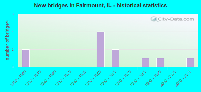
- New bridges - historical statistics
- 21900-1909
- 41950-1959
- 21960-1969
- 11980-1989
- 11990-1999
- 12010-2019

- Bridge Condition - Deck
- 11.1%Good
- 66.7%Satisfactory
- 22.2%Fair

- Bridge Condition - Superstructure
- 11.1%Good
- 66.7%Satisfactory
- 22.2%Fair

- Bridge Condition - Substructure
- 22.2%Very good
- 44.4%Good
- 33.3%Satisfactory

- Bridge Condition - Channel
- 9.1%Very good
- 63.6%Good
- 27.3%Satisfactory

- Bridge Condition - Culverts
- 50.0%Good
- 50.0%Satisfactory
Find on map >> Show street view
Structure Number: 920092, Location: N OF FAIRMOUNT (Lat: 40.057472, Lng: -87.836561), Route carried "on" structure: County highway , Year Built: 1958, Status: Open, Structure Length: 2.90m (9.51ft), Average Daily Traffic: 1,650 (year 2019), Truck Traffic: 12%, Average Future Daily Traffic: 2,670 (year 2032), Design Load: HS 20, Features Intersected: JORDAN CREEK, Facility Carried by Structure: FAS 512(CH 8)
Minimum Vertical Clearance: 30+ m (98+ ft), Kilometerpoint: 9.060, Lanes on structure: 2, Owner: County Highway Agency, Approaching Roadway Width: 6.7m (22.0ft), Skew: 4 degrees, Material/Design: Concrete continuous, Design/Construction: Slab, Number Of Spans In Main Unit: 3, Length of Maximum Span: 10.8m (35.4ft), Curb or Sidewalk Widths: Left: 0.6m (2.0ft), Right: 0.6m (2.0ft), Curb-To-Curb Width: 8.5m (27.9ft), Out-to-Out Width: 10.5m (34.4ft)
Condition: Deck: Satisfactory, Superstructure: Satisfactory, Substructure: Good, Channel: Good, Operating Rating: 56.7 metric tons, Method Used To Determine Operating Rating: Load Factor (LF) rating reported by rating factor (RF) method using MS18 loading, Inventory Rating: 34.0 metric tons, Method Used To Determine Inventory Rating: Load Factor (LF) rating reported by rating factor (RF) method using MS18 loading, Structural Evaluation: Equal to present minimum criteria, Deck Geometry: Somewhat better than minimum adequacy, Waterway Adequacy: Equal to present desirable criteria, Approach Roadway Alignment: Equal to present desirable criteria, Designated Inspection Frequency: Every 24 months, Inspection Date: Febuary 2021, Deck Structure Type: Concrete Cast-file-Place, Wearing Surface/Protective System: Wearing Surface: Bituminous, Membrane: Built-up
Find on map >> Show street view
Structure Number: 920093, Location: N OF FAIRMOUNT (Lat: 40.058683, Lng: -87.833125), Route carried "on" structure: County highway , Year Built: 1951, Status: Open, Structure Length: 0.75m (2.46ft), Average Daily Traffic: 1,650 (year 2019), Truck Traffic: 12%, Average Future Daily Traffic: 2,670 (year 2032), Design Load: HS 20, Features Intersected: JORDAN CREEK, Facility Carried by Structure: FAS 512(CH 8)
Minimum Vertical Clearance: 30+ m (98+ ft), Kilometerpoint: 9.382, Lanes on structure: 2, Owner: County Highway Agency, Approaching Roadway Width: 6.7m (22.0ft), Material/Design: Concrete, Design/Construction: Slab, Number Of Spans In Main Unit: 1, Length of Maximum Span: 7.2m (23.6ft), Curb-To-Curb Width: 10.6m (34.8ft), Out-to-Out Width: 11.7m (38.4ft)
Condition: Deck: Fair, Superstructure: Fair, Substructure: Good, Channel: Good, Operating Rating: 54.4 metric tons, Method Used To Determine Operating Rating: Allowable Stress (AS) rating reported by rating factor (RF) method using MS18 loading, Inventory Rating: 33.4 metric tons, Method Used To Determine Inventory Rating: Allowable Stress (AS) rating reported by rating factor (RF) method using MS18 loading, Structural Evaluation: Somewhat better than minimum adequacy, Deck Geometry: Equal to present minimum criteria, Waterway Adequacy: Equal to present desirable criteria, Approach Roadway Alignment: Equal to present desirable criteria, Designated Inspection Frequency: Every 24 months, Other Special Inspection Frequency: Every 24 months, Inspection Date: Febuary 2022, Other Special Inspection Date: January 2022, Deck Structure Type: Concrete Cast-file-Place, Wearing Surface/Protective System: Wearing Surface: Bituminous
Find on map >> Show street view
Structure Number: 920094, Location: 1.1 MI S FAIRMOUNT (Lat: 40.025394, Lng: -87.829525), Route carried "on" structure: County highway , Year Built: 1953, Status: Open, Structure Length: 1.16m (3.81ft), Average Daily Traffic: 1,100 (year 2019), Truck Traffic: 11%, Average Future Daily Traffic: 1,181 (year 2032), Design Load: HS 20, Features Intersected: JORDAN CREEK, Facility Carried by Structure: FAS 513(CH 18)
Minimum Vertical Clearance: 30+ m (98+ ft), Kilometerpoint: 3.798, Lanes on structure: 2, Owner: State Highway Agency, Approaching Roadway Width: 9.1m (29.9ft), Material/Design: Steel, Design/Construction: Stringer/Multi-beam, Number Of Spans In Main Unit: 1, Length of Maximum Span: 11.2m (36.7ft), Curb-To-Curb Width: 9.8m (32.2ft), Out-to-Out Width: 11.0m (36.1ft)
Condition: Deck: Satisfactory, Superstructure: Satisfactory, Substructure: Good, Channel: Good, Operating Rating: 55.4 metric tons, Method Used To Determine Operating Rating: Load Factor (LF) rating reported by rating factor (RF) method using MS18 loading, Inventory Rating: 33.4 metric tons, Method Used To Determine Inventory Rating: Load Factor (LF) rating reported by rating factor (RF) method using MS18 loading, Structural Evaluation: Equal to present minimum criteria, Deck Geometry: Somewhat better than minimum adequacy, Waterway Adequacy: Equal to present desirable criteria, Approach Roadway Alignment: Equal to present desirable criteria, Designated Inspection Frequency: Every 24 months, Inspection Date: March 2021, Deck Structure Type: Concrete Cast-file-Place, Wearing Surface/Protective System: Wearing Surface: Bituminous, Membrane: Built-up
Find on map >> Show street view
Structure Number: 920134, Location: 3 MI W OF FAIRMOUNT (Lat: 40.047586, Lng: -87.890317), Route carried "on" structure: County highway , Year Built: 1961, Status: Open, Structure Length: 0.66m (2.17ft), Average Daily Traffic: 1,500 (year 2019), Truck Traffic: 17%, Average Future Daily Traffic: 1,438 (year 2032), Design Load: HS 20+Mod, Features Intersected: STREAM, Facility Carried by Structure: FAS 512(CH 8)
Minimum Vertical Clearance: 30+ m (98+ ft), Kilometerpoint: 4.249, Lanes on structure: 2, Owner: County Highway Agency, Approaching Roadway Width: 6.7m (22.0ft), Material/Design: Concrete, Design/Construction: Culvert, Number Of Spans In Main Unit: 2, Length of Maximum Span: 3.0m (9.8ft)
Condition: Channel: Satisfactory, Culverts: Satisfactory, Operating Rating: 68.4 metric tons, Method Used To Determine Operating Rating: Allowable Stress (AS) rating reported by rating factor (RF) method using MS18 loading, Inventory Rating: 40.8 metric tons, Method Used To Determine Inventory Rating: Allowable Stress (AS) rating reported by rating factor (RF) method using MS18 loading, Structural Evaluation: Equal to present minimum criteria, Waterway Adequacy: Equal to present desirable criteria, Approach Roadway Alignment: Equal to present desirable criteria, Designated Inspection Frequency: Every 24 months, Inspection Date: Febuary 2021
Find on map >> Show street view
Structure Number: 920135, Location: 2 MI W OF FAIRMOUNT (Lat: 40.048078, Lng: -87.867956), Route carried "on" structure: County highway , Year Built: 1959, Status: Open, Structure Length: 0.66m (2.17ft), Average Daily Traffic: 1,500 (year 2019), Truck Traffic: 17%, Average Future Daily Traffic: 1,438 (year 2032), Design Load: HS 20, Features Intersected: STREAM, Facility Carried by Structure: FAS 512(CH 8)
Minimum Vertical Clearance: 30+ m (98+ ft), Kilometerpoint: 6.164, Lanes on structure: 2, Owner: County Highway Agency, Approaching Roadway Width: 6.7m (22.0ft), Material/Design: Concrete, Design/Construction: Culvert, Number Of Spans In Main Unit: 2, Length of Maximum Span: 3.0m (9.8ft)
Condition: Channel: Satisfactory, Culverts: Good, Operating Rating: 44.1 metric tons, Method Used To Determine Operating Rating: Allowable Stress (AS) rating reported by rating factor (RF) method using MS18 loading, Inventory Rating: 32.4 metric tons, Method Used To Determine Inventory Rating: Allowable Stress (AS) rating reported by rating factor (RF) method using MS18 loading, Structural Evaluation: Better than present minimum criteria, Waterway Adequacy: Equal to present desirable criteria, Approach Roadway Alignment: Equal to present desirable criteria, Designated Inspection Frequency: Every 24 months, Inspection Date: Febuary 2021
Find on map >> Show street view
Structure Number: 923061, Location: 2 MI NW FAIRMOUNT (Lat: 40.065336, Lng: -87.863303), Route carried "on" structure: County highway , Year Built: 1965, Status: Open, Structure Length: 3.41m (11.19ft), Average Daily Traffic: 325 (year 2019), Truck Traffic: 4%, Average Future Daily Traffic: 462 (year 2032), Design Load: HS 15, Features Intersected: SALT FORK, Facility Carried by Structure: TR 54
Minimum Vertical Clearance: 30+ m (98+ ft), Kilometerpoint: 3.154, Lanes on structure: 2, Owner: Town or Township Highway Agency, Approaching Roadway Width: 9.1m (29.9ft), Material/Design: Steel, Design/Construction: Stringer/Multi-beam, Number Of Spans In Main Unit: 1, Length of Maximum Span: 33.5m (109.9ft), Curb-To-Curb Width: 7.3m (24.0ft), Out-to-Out Width: 8.1m (26.6ft)
Condition: Deck: Satisfactory, Superstructure: Satisfactory, Substructure: Satisfactory, Channel: Good, Operating Rating: 42.4 metric tons, Method Used To Determine Operating Rating: Load Factor (LF) rating reported by rating factor (RF) method using MS18 loading, Inventory Rating: 25.6 metric tons, Method Used To Determine Inventory Rating: Load Factor (LF) rating reported by rating factor (RF) method using MS18 loading, Structural Evaluation: Equal to present minimum criteria, Deck Geometry: Somewhat better than minimum adequacy, Waterway Adequacy: Equal to present desirable criteria, Approach Roadway Alignment: Equal to present minimum criteria, Designated Inspection Frequency: Every 24 months, Inspection Date: Febuary 2021, Deck Structure Type: Concrete Cast-file-Place, Wearing Surface/Protective System: Wearing Surface: Gravel
Find on map >> Show street view
Structure Number: 923195, Location: 1 MI W FAIRMOUNT (Lat: 40.041011, Lng: -87.846694), Route carried "on" structure: County highway , Year Built: 1900, Status: Open, Structure Length: 1.04m (3.41ft), Average Daily Traffic: 75 (year 2019), Truck Traffic: 3%, Average Future Daily Traffic: 180 (year 2032), Features Intersected: JORDAN CREEK, Facility Carried by Structure: TR 355
Minimum Vertical Clearance: 30+ m (98+ ft), Kilometerpoint: 1.352, Lanes on structure: 2, Owner: Town or Township Highway Agency, Approaching Roadway Width: 9.1m (29.9ft), Material/Design: Concrete, Design/Construction: Slab, Number Of Spans In Main Unit: 1, Length of Maximum Span: 10.1m (33.1ft), Curb-To-Curb Width: 7.4m (24.3ft), Out-to-Out Width: 8.4m (27.6ft)
Condition: Deck: Satisfactory, Superstructure: Satisfactory, Substructure: Satisfactory, Channel: Good, Operating Rating: 40.5 metric tons, Method Used To Determine Operating Rating: Field evaluation and documented engineering judgment, Inventory Rating: 24.3 metric tons, Method Used To Determine Inventory Rating: Field evaluation and documented engineering judgment, Structural Evaluation: Equal to present minimum criteria, Deck Geometry: Equal to present minimum criteria, Waterway Adequacy: Equal to present minimum criteria, Approach Roadway Alignment: Equal to present minimum criteria, Designated Inspection Frequency: Every 24 months, Inspection Date: Febuary 2022, Deck Structure Type: Concrete Cast-file-Place
Find on map >> Show street view
Structure Number: 923197, Location: 1 MI S FAIRMOUNT (Lat: 40.026597, Lng: -87.834164), Route carried "on" structure: County highway , Year Built: 1900, Status: Open, Structure Length: 0.94m (3.08ft), Average Daily Traffic: 50 (year 2019), Truck Traffic: 4%, Average Future Daily Traffic: 51 (year 2032), Features Intersected: JORDAN CREEK, Facility Carried by Structure: TR 361
Minimum Vertical Clearance: 30+ m (98+ ft), Kilometerpoint: 2.414, Lanes on structure: 2, Owner: Town or Township Highway Agency, Approaching Roadway Width: 7.9m (25.9ft), Skew: 3 degrees, Material/Design: Concrete, Design/Construction: Slab, Number Of Spans In Main Unit: 1, Length of Maximum Span: 9.1m (29.9ft), Curb-To-Curb Width: 6.2m (20.3ft), Out-to-Out Width: 7.1m (23.3ft)
Condition: Deck: Fair, Superstructure: Fair, Substructure: Satisfactory, Channel: Satisfactory, Operating Rating: 40.5 metric tons, Method Used To Determine Operating Rating: Field evaluation and documented engineering judgment, Inventory Rating: 24.3 metric tons, Method Used To Determine Inventory Rating: Field evaluation and documented engineering judgment, Structural Evaluation: Somewhat better than minimum adequacy, Deck Geometry: Somewhat better than minimum adequacy, Waterway Adequacy: Equal to present minimum criteria, Approach Roadway Alignment: Equal to present minimum criteria, Designated Inspection Frequency: Every 24 months, Inspection Date: Febuary 2021, Deck Structure Type: Concrete Cast-file-Place
Find on map >> Show street view
Structure Number: 923324, Location: 2 MI N FAIRMOUNT (Lat: 40.069364, Lng: -87.825322), Route carried "on" structure: County highway , Year Built: 1981, Status: Open, Structure Length: 2.96m (9.71ft), Average Daily Traffic: 75 (year 2019), Truck Traffic: 17%, Average Future Daily Traffic: 112 (year 2032), Design Load: HS 20, Features Intersected: JORDAN CREEK, Facility Carried by Structure: TR 86
Minimum Vertical Clearance: 30+ m (98+ ft), Kilometerpoint: 0.982, Lanes on structure: 2, Owner: Town or Township Highway Agency, Approaching Roadway Width: 7.9m (25.9ft), Skew: 1 degrees, Material/Design: Prestressed concrete, Design/Construction: Box Beam or Girders - Multiple, Number Of Spans In Main Unit: 2, Length of Maximum Span: 19.5m (64.0ft), Curb-To-Curb Width: 8.2m (26.9ft), Out-to-Out Width: 8.2m (26.9ft)
Condition: Deck: Satisfactory, Superstructure: Satisfactory, Substructure: Good, Channel: Good, Operating Rating: 44.4 metric tons, Method Used To Determine Operating Rating: Assigned rating based on Load Factor Design (LFD) reported by rating factor (RF) using MS18 loading, Inventory Rating: 32.4 metric tons, Method Used To Determine Inventory Rating: Assigned rating based on Load Factor Design (LFD) reported by rating factor (RF) using MS18 loading, Structural Evaluation: Equal to present minimum criteria, Deck Geometry: Equal to present minimum criteria, Waterway Adequacy: Equal to present minimum criteria, Approach Roadway Alignment: Better than present minimum criteria, Designated Inspection Frequency: Every 24 months, Inspection Date: Febuary 2021, Deck Structure Type: Concrete Precast Panels
Find on map >> Show street view
Structure Number: 923464, Location: 1 MI NE FAIRMOUNT (Lat: 40.054703, Lng: -87.810803), Route carried "on" structure: County highway , Year Built: 1997, Status: Open, Structure Length: 1.52m (4.99ft), Average Daily Traffic: 50 (year 2019), Truck Traffic: 4%, Average Future Daily Traffic: 61 (year 2032), Design Load: HS 20, Features Intersected: STREAM, Facility Carried by Structure: TR 84 A
Minimum Vertical Clearance: 30+ m (98+ ft), Kilometerpoint: 6.164, Lanes on structure: 2, Owner: Town or Township Highway Agency, Approaching Roadway Width: 7.0m (23.0ft), Material/Design: Prestressed concrete, Design/Construction: Box Beam or Girders - Multiple, Number Of Spans In Main Unit: 1, Length of Maximum Span: 14.5m (47.6ft), Curb-To-Curb Width: 8.2m (26.9ft), Out-to-Out Width: 8.2m (26.9ft)
Condition: Deck: Satisfactory, Superstructure: Satisfactory, Substructure: Very good, Channel: Good, Operating Rating: 44.1 metric tons, Method Used To Determine Operating Rating: Assigned rating based on Load Factor Design (LFD) reported by rating factor (RF) using MS18 loading, Inventory Rating: 32.4 metric tons, Method Used To Determine Inventory Rating: Assigned rating based on Load Factor Design (LFD) reported by rating factor (RF) using MS18 loading, Structural Evaluation: Equal to present minimum criteria, Deck Geometry: Equal to present minimum criteria, Waterway Adequacy: Equal to present desirable criteria, Approach Roadway Alignment: Equal to present desirable criteria, Designated Inspection Frequency: Every 24 months, Inspection Date: Febuary 2022, Deck Structure Type: Concrete Precast Panels
Find on map >> Show street view
Structure Number: 923508, Location: IN JAMAICA (Lat: 39.992161, Lng: -87.809808), Route carried "on" structure: County highway , Year Built: 2012, Status: Open, Structure Length: 1.52m (4.99ft), Average Daily Traffic: 25 (year 2019), Truck Traffic: 8%, Average Future Daily Traffic: 50 (year 2034), Design Load: HS 25 or greater, Features Intersected: JORDAN CREEK, Facility Carried by Structure: TR 92
Minimum Vertical Clearance: 30+ m (98+ ft), Kilometerpoint: 3.862, Lanes on structure: 2, Owner: Town or Township Highway Agency, Approaching Roadway Width: 4.3m (14.1ft), Material/Design: Prestressed concrete, Design/Construction: Box Beam or Girders - Multiple, Number Of Spans In Main Unit: 1, Length of Maximum Span: 14.5m (47.6ft), Curb-To-Curb Width: 8.2m (26.9ft), Out-to-Out Width: 8.2m (26.9ft)
Condition: Deck: Good, Superstructure: Good, Substructure: Very good, Channel: Very good, Operating Rating: 44.1 metric tons, Method Used To Determine Operating Rating: Assigned rating based on Load Factor Design (LFD) reported by rating factor (RF) using MS18 loading, Inventory Rating: 32.4 metric tons, Method Used To Determine Inventory Rating: Assigned rating based on Load Factor Design (LFD) reported by rating factor (RF) using MS18 loading, Structural Evaluation: Better than present minimum criteria, Deck Geometry: Equal to present minimum criteria, Waterway Adequacy: Superior to present desirable criteria, Approach Roadway Alignment: Equal to present desirable criteria, Designated Inspection Frequency: Every 48 months, Inspection Date: Febuary 2019, Deck Structure Type: Other, Wearing Surface/Protective System: Deck Protection: Epoxy Coated Reinforcing