Bridge Statistics for Fairmont City, Illinois (IL)
Condition, Traffic, Stress, Structural Evaluation, Project Costs
- National Bridge Inventory (NBI) Statistics
- 19Number of bridges
- 541ft / 165mTotal length
- $1,594,000Total costs
- 217,200Total average daily traffic
- 33,415Total average daily truck traffic
- National Bridge Inventory (NBI) Registered Bridges for Fairmont City
- No street view available for this location
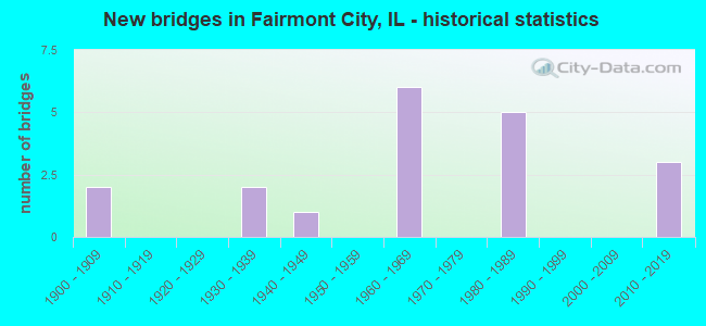
- New bridges - historical statistics
- 21900-1909
- 21930-1939
- 11940-1949
- 61960-1969
- 51980-1989
- 32010-2019

- Reconstructed bridges - Historical Statistics
- 21980-1989
- 11990-1999


- Bridge Condition - Deck
- 9.1%Very good
- 27.3%Good
- 27.3%Satisfactory
- 27.3%Fair
- 9.1%Poor

- Bridge Condition - Superstructure
- 18.2%Very good
- 18.2%Good
- 27.3%Satisfactory
- 27.3%Fair
- 9.1%Poor

- Bridge Condition - Substructure
- 18.2%Very good
- 36.4%Good
- 36.4%Satisfactory
- 9.1%Serious
Find on map >> Show street view
Structure Number: 600006, Location: N OF FAIRMONT CITY (Lat: 38.662672, Lng: -90.093108), Route carried "on" structure: Interstate 55, Year Built: 1961, Status: Open, Structure Length: 7.38m (24.21ft), Average Daily Traffic: 25,850 (year 2021), Truck Traffic: 16%, Average Future Daily Traffic: 24,857 (year 2032), Design Load: HS 20, Features Intersected: ILL 111, Facility Carried by Structure: FAI 70 EB
Minimum Vertical Clearance: 30+ m (98+ ft), Kilometerpoint: 10.074, Lanes on structure: 3, Lanes under structure: 2, Base Highway Network: Yes, Owner: State Highway Agency, Approaching Roadway Width: 17.1m (56.1ft), Skew: 1 degrees, Material/Design: Steel continuous, Design/Construction: Stringer/Multi-beam, Number Of Spans In Main Unit: 5, Number Of Approach Spans: 2, Length of Maximum Span: 16.2m (53.1ft), Curb-To-Curb Width: 17.1m (56.1ft), Out-to-Out Width: 18.0m (59.1ft)
Condition: Deck: Fair, Superstructure: Satisfactory, Substructure: Satisfactory, Operating Rating: 46.0 metric tons, Method Used To Determine Operating Rating: Load Factor (LF) rating reported by rating factor (RF) method using MS18 loading, Inventory Rating: 27.5 metric tons, Method Used To Determine Inventory Rating: Load Factor (LF) rating reported by rating factor (RF) method using MS18 loading, Structural Evaluation: Equal to present minimum criteria, Deck Geometry: Equal to present minimum criteria, Underclear: Meets minimum limits, Approach Roadway Alignment: Equal to present minimum criteria, Designated Inspection Frequency: Every 24 months, Other Special Inspection Frequency: Every 48 months, Inspection Date: September 2021, Other Special Inspection Date: March 2018, Deck Structure Type: Concrete Cast-file-Place, Wearing Surface/Protective System: Wearing Surface: Other
Find on map >> Show street view
Structure Number: 600007, Location: N OF FAIRMONT CITY (Lat: 38.662669, Lng: -90.092519), Route carried "on" structure: Interstate 55, Year Built: 1961, Status: Open, Structure Length: 7.38m (24.21ft), Average Daily Traffic: 25,850 (year 2021), Truck Traffic: 16%, Average Future Daily Traffic: 24,857 (year 2032), Design Load: HS 20, Features Intersected: ILL 111, Facility Carried by Structure: FAI 70 WB
Minimum Vertical Clearance: 30+ m (98+ ft), Kilometerpoint: 10.106, Lanes on structure: 3, Lanes under structure: 2, Base Highway Network: Yes, Owner: State Highway Agency, Approaching Roadway Width: 17.1m (56.1ft), Skew: 1 degrees, Material/Design: Steel continuous, Design/Construction: Stringer/Multi-beam, Number Of Spans In Main Unit: 5, Number Of Approach Spans: 2, Length of Maximum Span: 16.2m (53.1ft), Curb-To-Curb Width: 17.1m (56.1ft), Out-to-Out Width: 18.0m (59.1ft)
Condition: Deck: Fair, Superstructure: Satisfactory, Substructure: Satisfactory, Operating Rating: 46.0 metric tons, Method Used To Determine Operating Rating: Load Factor (LF) rating reported by rating factor (RF) method using MS18 loading, Inventory Rating: 27.5 metric tons, Method Used To Determine Inventory Rating: Load Factor (LF) rating reported by rating factor (RF) method using MS18 loading, Structural Evaluation: Equal to present minimum criteria, Deck Geometry: Equal to present minimum criteria, Underclear: Meets minimum limits, Approach Roadway Alignment: Equal to present minimum criteria, Designated Inspection Frequency: Every 24 months, Other Special Inspection Frequency: Every 48 months, Inspection Date: September 2021, Other Special Inspection Date: March 2018, Deck Structure Type: Concrete Cast-file-Place, Wearing Surface/Protective System: Wearing Surface: Other
Find on map >> Show street view
Structure Number: 600208, Location: .75 MI EAST ILL 111 (Lat: 38.662589, Lng: -90.078131), Route carried "on" structure: Interstate 55, Year Built: 1980, Status: Open, Structure Length: 12.53m (41.11ft), Average Daily Traffic: 25,850 (year 2021), Truck Traffic: 16%, Average Future Daily Traffic: 24,857 (year 2032), Design Load: HS 20, Features Intersected: A&S RAILROAD
Minimum Vertical Clearance: 30+ m (98+ ft), Kilometerpoint: 11.152, Lanes on structure: 3, Base Highway Network: Yes, Owner: State Highway Agency, Approaching Roadway Width: 17.1m (56.1ft), Material/Design: Steel continuous, Design/Construction: Stringer/Multi-beam, Number Of Spans In Main Unit: 5, Length of Maximum Span: 30.5m (100.1ft), Curb-To-Curb Width: 17.2m (56.4ft), Out-to-Out Width: 18.0m (59.1ft)
Condition: Deck: Satisfactory, Superstructure: Fair, Substructure: Good, Operating Rating: 55.1 metric tons, Method Used To Determine Operating Rating: Load Factor (LF) rating reported by rating factor (RF) method using MS18 loading, Inventory Rating: 32.4 metric tons, Method Used To Determine Inventory Rating: Load Factor (LF) rating reported by rating factor (RF) method using MS18 loading, Structural Evaluation: Somewhat better than minimum adequacy, Deck Geometry: Better than present minimum criteria, Underclear: Better than present minimum criteria, Approach Roadway Alignment: Equal to present minimum criteria, Designated Inspection Frequency: Every 24 months, Inspection Date: December 2020, Deck Structure Type: Concrete Cast-file-Place, Wearing Surface/Protective System: Deck Protection: Epoxy Coated Reinforcing
Find on map >> Show street view
Structure Number: 600209, Location: .75 MI EAST ILL 111 (Lat: 38.662589, Lng: -90.077983), Route carried "on" structure: Interstate 55, Year Built: 1980, Status: Open, Structure Length: 12.53m (41.11ft), Average Daily Traffic: 25,850 (year 2021), Truck Traffic: 16%, Average Future Daily Traffic: 24,857 (year 2032), Design Load: HS 20, Features Intersected: A&S RAILROAD
Minimum Vertical Clearance: 30+ m (98+ ft), Kilometerpoint: 11.169, Lanes on structure: 3, Base Highway Network: Yes, Owner: State Highway Agency, Approaching Roadway Width: 17.1m (56.1ft), Material/Design: Steel continuous, Design/Construction: Stringer/Multi-beam, Number Of Spans In Main Unit: 5, Length of Maximum Span: 30.5m (100.1ft), Curb-To-Curb Width: 17.2m (56.4ft), Out-to-Out Width: 18.0m (59.1ft)
Condition: Deck: Satisfactory, Superstructure: Fair, Substructure: Satisfactory, Operating Rating: 53.8 metric tons, Method Used To Determine Operating Rating: Load Factor (LF) rating reported by rating factor (RF) method using MS18 loading, Inventory Rating: 31.4 metric tons, Method Used To Determine Inventory Rating: Load Factor (LF) rating reported by rating factor (RF) method using MS18 loading, Structural Evaluation: Somewhat better than minimum adequacy, Deck Geometry: Better than present minimum criteria, Underclear: Better than present minimum criteria, Approach Roadway Alignment: Equal to present minimum criteria, Designated Inspection Frequency: Every 24 months, Inspection Date: December 2020, Deck Structure Type: Concrete Cast-file-Place, Wearing Surface/Protective System: Deck Protection: Epoxy Coated Reinforcing
Find on map >> Show street view
Structure Number: 820024, Location: 0.4 M E E ST LOUIS (Lat: 38.643161, Lng: -90.130692), Route carried "on" structure: Other road , Year Built: 1960, Year Reconstructed: 1999, Status: Open, Structure Length: 13.96m (45.80ft), Average Daily Traffic: 7,600 (year 2018), Truck Traffic: 14%, Average Future Daily Traffic: 10,251 (year 2032), Design Load: HS 20, Features Intersected: DRNG CANAL & I-55/70, Facility Carried by Structure: RAMP TO IL 203 NB
Minimum Vertical Clearance: 30+ m (98+ ft), Kilometerpoint: 0.435, Lanes on structure: 2, Lanes under structure: 8, Base Highway Network: Yes (Inventory Route: 10070040, Subroute: 20), Owner: State Highway Agency, Approaching Roadway Width: 13.4m (44.0ft), Skew: 2 degrees, Material/Design: Steel continuous, Design/Construction: Stringer/Multi-beam, Number Of Spans In Main Unit: 6, Length of Maximum Span: 29.6m (97.1ft), Curb-To-Curb Width: 9.1m (29.9ft), Out-to-Out Width: 10.9m (35.8ft)
Condition: Deck: Good, Superstructure: Good, Substructure: Good, Channel: Good, Operating Rating: 89.1 metric tons, Method Used To Determine Operating Rating: Load Factor (LF) rating reported by rating factor (RF) method using MS18 loading, Inventory Rating: 66.1 metric tons, Method Used To Determine Inventory Rating: Load Factor (LF) rating reported by rating factor (RF) method using MS18 loading, Structural Evaluation: Better than present minimum criteria, Deck Geometry: Meets minimum limits, Underclear: Meets minimum limits, Waterway Adequacy: Superior to present desirable criteria, Approach Roadway Alignment: Better than present minimum criteria, Length Of Structure Improvement: 13.96m (45.80ft), Designated Inspection Frequency: Every 24 months, Inspection Date: January 2022, Bridge Improvement Cost: $1,141,000, Roadway Improvement Cost: $114,000, Total Project Cost: $1,255,000, Deck Structure Type: Concrete Cast-file-Place, Wearing Surface/Protective System: Deck Protection: Epoxy Coated Reinforcing
Find on map >> Show street view
Structure Number: 820029, Location: 0.1 M N OLD US 40 (Lat: 38.642747, Lng: -90.127231), Route carried "on" structure: State highway 203, Year Built: 1960, Year Reconstructed: 1993, Status: Open, Structure Length: 2.80m (9.19ft), Average Daily Traffic: 4,000 (year 2021), Truck Traffic: 16%, Average Future Daily Traffic: 4,132 (year 2032), Design Load: HS 20, Features Intersected: DRNG TO CAHOKIA CNL
Minimum Vertical Clearance: 30+ m (98+ ft), Kilometerpoint: 0.097, Lanes on structure: 4, Base Highway Network: Yes, Owner: State Highway Agency, Approaching Roadway Width: 17.7m (58.1ft), Skew: 31 degrees, Material/Design: Steel continuous, Design/Construction: Stringer/Multi-beam, Number Of Spans In Main Unit: 3, Length of Maximum Span: 9.8m (32.2ft), Curb-To-Curb Width: 16.5m (54.1ft), Out-to-Out Width: 20.1m (65.9ft)
Condition: Deck: Poor, Superstructure: Satisfactory, Substructure: Good, Channel: Good, Operating Rating: 56.7 metric tons, Method Used To Determine Operating Rating: Load Factor (LF) rating reported by rating factor (RF) method using MS18 loading, Inventory Rating: 34.0 metric tons, Method Used To Determine Inventory Rating: Load Factor (LF) rating reported by rating factor (RF) method using MS18 loading, Structural Evaluation: Equal to present minimum criteria, Deck Geometry: Meets minimum limits, Waterway Adequacy: Better than present minimum criteria, Approach Roadway Alignment: Equal to present desirable criteria, Designated Inspection Frequency: Every 24 months, Inspection Date: January 2022, Deck Structure Type: Concrete Cast-file-Place
Find on map >> Show street view
Structure Number: 820031, Location: 0.5 M E JCT ILL 203 (Lat: 38.641847, Lng: -90.123997), Route carried "on" structure: Other road , Year Built: 1947, Status: Posted for load, Structure Length: 0.98m (3.22ft), Average Daily Traffic: 3,600 (year 2018), Truck Traffic: 17%, Average Future Daily Traffic: 4,655 (year 2032), Design Load: HS 20, Features Intersected: SCHOENBERGER CK, Facility Carried by Structure: COLLINSVILLE RD
Minimum Vertical Clearance: 30+ m (98+ ft), Kilometerpoint: 0.274, Lanes on structure: 4, Base Highway Network: Yes, Owner: State Highway Agency, Approaching Roadway Width: 14.6m (47.9ft), Material/Design: Concrete, Design/Construction: Slab, Number Of Spans In Main Unit: 1, Length of Maximum Span: 9.4m (30.8ft), Curb-To-Curb Width: 17.1m (56.1ft), Out-to-Out Width: 18.3m (60.0ft)
Condition: Deck: Fair, Superstructure: Fair, Substructure: Satisfactory, Channel: Good, Operating Rating: 32.4 metric tons, Method Used To Determine Operating Rating: Load Factor (LF) rating reported by rating factor (RF) method using MS18 loading, Inventory Rating: 19.4 metric tons, Method Used To Determine Inventory Rating: Load Factor (LF) rating reported by rating factor (RF) method using MS18 loading, Structural Evaluation: Somewhat better than minimum adequacy, Deck Geometry: Somewhat better than minimum adequacy, Waterway Adequacy: Equal to present minimum criteria, Approach Roadway Alignment: Equal to present desirable criteria, Bridge Posting: Required (Relationship of Operating Rating to Maximum Legal Load: > 39.9% below), Length Of Structure Improvement: 0.98m (3.22ft), Designated Inspection Frequency: Every 12 months, Inspection Date: Febuary 2022, Bridge Improvement Cost: $304,000, Roadway Improvement Cost: $30,000, Total Project Cost: $339,000, Deck Structure Type: Concrete Cast-file-Place, Wearing Surface/Protective System: Wearing Surface: Bituminous, Membrane: Built-up
Find on map >> Show street view
Structure Number: 820098, Location: N EDGE WASHINGTON PK (Lat: 38.645200, Lng: -90.093181), Route carried "on" structure: State highway 111, Year Built: 1935, Year Reconstructed: 1985, Status: Open, Structure Length: 20.86m (68.44ft), Average Daily Traffic: 3,050 (year 2021), Truck Traffic: 6%, Average Future Daily Traffic: 4,079 (year 2032), Design Load: HS 20, Features Intersected: CONRAIL & B&O RR'S
Minimum Vertical Clearance: 30+ m (98+ ft), Kilometerpoint: 5.166, Lanes on structure: 2, Base Highway Network: Yes, Owner: State Highway Agency, Approaching Roadway Width: 13.4m (44.0ft), Material/Design: Steel continuous, Design/Construction: Stringer/Multi-beam, Number Of Spans In Main Unit: 11, Length of Maximum Span: 21.9m (71.9ft), Curb or Sidewalk Widths: Left: 0.0m, Right: 1.5m (4.9ft), Curb-To-Curb Width: 9.1m (29.9ft), Out-to-Out Width: 11.5m (37.7ft)
Condition: Deck: Satisfactory, Superstructure: Poor, Substructure: Serious, Operating Rating: 52.2 metric tons, Method Used To Determine Operating Rating: Load Factor (LF) rating reported by rating factor (RF) method using MS18 loading, Inventory Rating: 31.1 metric tons, Method Used To Determine Inventory Rating: Load Factor (LF) rating reported by rating factor (RF) method using MS18 loading, Structural Evaluation: High priority of corrective action, Deck Geometry: Meets minimum limits, Underclear: Somewhat better than minimum adequacy, Approach Roadway Alignment: Equal to present minimum criteria, Designated Inspection Frequency: Every 12 months, Other Special Inspection Frequency: Every 3 months, Inspection Date: July 2021, Other Special Inspection Date: January 2022, Deck Structure Type: Concrete Cast-file-Place, Wearing Surface/Protective System: Deck Protection: Epoxy Coated Reinforcing
Find on map >> Show street view
Structure Number: 820248, Location: 1MI S MADISON CO LN (Lat: 38.643656, Lng: -90.047053), Route carried "on" structure: Interstate 255, Year Built: 1985, Status: Open, Structure Length: 67.48m (221.39ft), Average Daily Traffic: 21,700 (year 2021), Truck Traffic: 15%, Average Future Daily Traffic: 24,215 (year 2032), Design Load: HS 20+Mod, Features Intersected: BLACK LN/B&O/CONRAIL
Minimum Vertical Clearance: 30+ m (98+ ft), Kilometerpoint: 29.804, Lanes on structure: 3, Lanes under structure: 2, Base Highway Network: Yes, Owner: State Highway Agency, Approaching Roadway Width: 17.1m (56.1ft), Skew: 3 degrees, Material/Design: Steel continuous, Design/Construction: Stringer/Multi-beam, Number Of Spans In Main Unit: 18, Length of Maximum Span: 40.2m (131.9ft), Curb-To-Curb Width: 17.1m (56.1ft), Out-to-Out Width: 18.0m (59.1ft)
Condition: Deck: Good, Superstructure: Good, Substructure: Good, Operating Rating: 71.9 metric tons, Method Used To Determine Operating Rating: Load Factor (LF) rating reported by rating factor (RF) method using MS18 loading, Inventory Rating: 30.8 metric tons, Method Used To Determine Inventory Rating: Load Factor (LF) rating reported by rating factor (RF) method using MS18 loading, Structural Evaluation: Better than present minimum criteria, Deck Geometry: Equal to present minimum criteria, Underclear: Superior to present desirable criteria, Approach Roadway Alignment: Equal to present desirable criteria, Designated Inspection Frequency: Every 24 months, Inspection Date: January 2021, Deck Structure Type: Concrete Cast-file-Place, Wearing Surface/Protective System: Wearing Surface: Bituminous, Membrane: Built-up, Deck Protection: Epoxy Coated Reinforcing
Find on map >> Show street view
Structure Number: 820328, Location: 0.8 mi N of I-55/64 (Lat: 38.641692, Lng: -90.154242), Route carried "on" structure: Other road , Year Built: 2013, Status: Open, Structure Length: 5.16m (16.93ft), Average Daily Traffic: 3,050 (year 2018), Truck Traffic: 32%, Average Future Daily Traffic: 1,402 (year 2037), Design Load: HS 25 or greater, Features Intersected: RELOCATED I-70, Facility Carried by Structure: REL IL 3 -Packers
Minimum Vertical Clearance: 30+ m (98+ ft), Kilometerpoint: 2.205, Lanes on structure: 2, Lanes under structure: 4, Base Highway Network: Yes, Owner: State Highway Agency, Approaching Roadway Width: 18.2m (59.7ft), Skew: 30 degrees, Material/Design: Steel continuous, Design/Construction: Stringer/Multi-beam, Number Of Spans In Main Unit: 2, Length of Maximum Span: 28.9m (94.8ft), Curb-To-Curb Width: 18.2m (59.7ft), Out-to-Out Width: 19.9m (65.3ft)
Condition: Deck: Very good, Superstructure: Very good, Substructure: Very good, Operating Rating: 67.4 metric tons, Method Used To Determine Operating Rating: Load and Resistance Factor Rating (LRFR) rating reported by rating factor(RF) method using HL-93 loadings, Inventory Rating: 52.2 metric tons, Method Used To Determine Inventory Rating: Load and Resistance Factor Rating (LRFR) rating reported by rating factor(RF) method using HL-93 loadings, Structural Evaluation: Equal to present desirable criteria, Deck Geometry: Superior to present desirable criteria, Underclear: High priority of corrective action, Approach Roadway Alignment: Equal to present desirable criteria, Designated Inspection Frequency: Every 24 months, Inspection Date: September 2021, Deck Structure Type: Concrete Cast-file-Place, Wearing Surface/Protective System: Deck Protection: Epoxy Coated Reinforcing
Find on map >> Show street view
Structure Number: 820329, Location: 0.8 mi N of I-55/64 (Lat: 38.640803, Lng: -90.155667), Route carried "on" structure: Other road , Year Built: 2013, Status: Open, Structure Length: 12.03m (39.47ft), Average Daily Traffic: 3,050 (year 2018), Truck Traffic: 32%, Average Future Daily Traffic: 1,870 (year 2037), Design Load: HS 25 or greater, Features Intersected: ST CLAIR AV &TRRA RR, Facility Carried by Structure: RELOCATED IL 3
Minimum Vertical Clearance: 30+ m (98+ ft), Kilometerpoint: 2.366, Lanes on structure: 2, Lanes under structure: 2, Base Highway Network: Yes, Owner: State Highway Agency, Approaching Roadway Width: 14.6m (47.9ft), Skew: 32 degrees, Material/Design: Steel continuous, Design/Construction: Stringer/Multi-beam, Number Of Spans In Main Unit: 3, Length of Maximum Span: 43.2m (141.7ft), Curb-To-Curb Width: 14.6m (47.9ft), Out-to-Out Width: 19.9m (65.3ft)
Condition: Deck: Good, Superstructure: Very good, Substructure: Very good, Operating Rating: 61.6 metric tons, Method Used To Determine Operating Rating: Load and Resistance Factor Rating (LRFR) rating reported by rating factor(RF) method using HL-93 loadings, Inventory Rating: 47.3 metric tons, Method Used To Determine Inventory Rating: Load and Resistance Factor Rating (LRFR) rating reported by rating factor(RF) method using HL-93 loadings, Structural Evaluation: Equal to present desirable criteria, Deck Geometry: Superior to present desirable criteria, Approach Roadway Alignment: Equal to present desirable criteria, Designated Inspection Frequency: Every 24 months, Inspection Date: September 2021, Deck Structure Type: Concrete Cast-file-Place, Wearing Surface/Protective System: Deck Protection: Epoxy Coated Reinforcing
Find on map >> Show street view
Structure Number: 82201, Location: 0.3 M N NATIONAL CTY (Lat: 38.643794, Lng: -90.159208), Route carried "on" structure: State highway 3, Year Built: 1935, Status: Open, Structure Length: 1.45m (4.76ft), Average Daily Traffic: 4,850 (year 2021), Truck Traffic: 22%, Average Future Daily Traffic: 6,590 (year 2032), Features Intersected: CAHOKIA CANAL
Minimum Vertical Clearance: 30+ m (98+ ft), Kilometerpoint: 237.694, Lanes on structure: 2, Base Highway Network: Yes, Owner: State Highway Agency, Approaching Roadway Width: 9.1m (29.9ft), Skew: 3 degrees, Material/Design: Concrete continuous, Design/Construction: Culvert, Number Of Spans In Main Unit: 3, Length of Maximum Span: 4.2m (13.8ft)
Condition: Channel: Good, Culverts: Satisfactory, Operating Rating: 82.9 metric tons, Method Used To Determine Operating Rating: Load Factor (LF) rating reported by rating factor (RF) method using MS18 loading, Inventory Rating: 49.6 metric tons, Method Used To Determine Inventory Rating: Load Factor (LF) rating reported by rating factor (RF) method using MS18 loading, Structural Evaluation: Equal to present minimum criteria, Waterway Adequacy: Better than present minimum criteria, Approach Roadway Alignment: Equal to present desirable criteria, Designated Inspection Frequency: Every 24 months, Inspection Date: September 2021
Find on map >> Show street view
Structure Number: 600006, Location: N OF FAIRMONT CITY (Lat: 38.662894, Lng: -90.093036), Route carried "under" structure: State highway 111, Year Built: 1961, Structure Length: 0. m, Average Daily Traffic: 4,100 (year 2021), Truck Traffic: 10%, Features Intersected: ILL 111, Facility Carried by Structure: FAI 70 EB
Minimum Vertical Clearance: 4.50m (14.76ft), Kilometerpoint: 7.371, Lanes on structure: 3, Lanes under structure: 2, Material/Design: Steel continuous, Design/Construction: Stringer/Multi-beam, Length of Maximum Span: 16.2m (53.1ft)
Find on map >> Show street view
Structure Number: 600007, Location: N OF FAIRMONT CITY (Lat: 38.663061, Lng: -90.092986), Route carried "under" structure: State highway 111, Year Built: 1961, Structure Length: 0. m, Average Daily Traffic: 4,100 (year 2021), Truck Traffic: 10%, Features Intersected: ILL 111, Facility Carried by Structure: FAI 70 WB
Minimum Vertical Clearance: 4.50m (14.76ft), Kilometerpoint: 7.387, Lanes on structure: 3, Lanes under structure: 2, Material/Design: Steel continuous, Design/Construction: Stringer/Multi-beam, Length of Maximum Span: 16.2m (53.1ft)
Find on map >> Show street view
Structure Number: 820247, Location: 1M S MADISON CO LINE (Lat: 38.643961, Lng: -90.047072), Route carried "under" structure: Other road , Year Built: 1985, Structure Length: 0. m, Average Daily Traffic: 2,300 (year 2018), Truck Traffic: 7%, Features Intersected: BLACK LN-B&O-CONRAIL, Facility Carried by Structure: FAI 255 SB
Minimum Vertical Clearance: 5.18m (16.99ft), Kilometerpoint: 1.625, Lanes on structure: 3, Lanes under structure: 2, Material/Design: Steel continuous, Design/Construction: Stringer/Multi-beam, Length of Maximum Span: 40.2m (131.9ft)
Find on map >> Show street view
Structure Number: 820248, Location: 1MI S MADISON CO LN (Lat: 38.643656, Lng: -90.047053), Route carried "under" structure: Other road , Year Built: 1985, Structure Length: 0. m, Average Daily Traffic: 2,300 (year 2018), Truck Traffic: 7%, Features Intersected: BLACK LN/B&O/CONRAIL, Facility Carried by Structure: FAI 255 NB
Minimum Vertical Clearance: 4.93m (16.17ft), Kilometerpoint: 1.641, Lanes on structure: 3, Lanes under structure: 2, Material/Design: Steel continuous, Design/Construction: Stringer/Multi-beam, Length of Maximum Span: 40.2m (131.9ft)
Find on map >> Show street view
Structure Number: 820328, Location: 0.8 mi N of I-55/64 (Lat: 38.641914, Lng: -90.154447), Route carried "under" structure: Interstate 70, Year Built: 2013, Structure Length: 0. m, Average Daily Traffic: 44,300 (year 2019), Truck Traffic: 14%, Features Intersected: RELOCATED I-70, Facility Carried by Structure: REL IL 3 -Packers
Minimum Vertical Clearance: 6.20m (20.34ft), Kilometerpoint: 2.591, Lanes on structure: 2, Lanes under structure: 4, Material/Design: Steel continuous, Design/Construction: Stringer/Multi-beam, Length of Maximum Span: 28.9m (94.8ft)
Find on map >> Show street view
Structure Number: 829903, Location: E. ST. LOUIS (Lat: 38.637325, Lng: -90.134300), Route carried "under" structure: Other road , Year Built: 1900, Structure Length: 0. m, Average Daily Traffic: 2,900 (year 2018), Truck Traffic: 13%, Features Intersected: 9TH ST FAU 9213, Facility Carried by Structure: TERMINAL R.R.
Minimum Vertical Clearance: 5.05m (16.57ft), Kilometerpoint: 2.398, Lanes under structure: 2, Material/Design: Concrete, Length of Maximum Span: 10.4m (34.1ft)
Find on map >> Show street view
Structure Number: 829904, Location: E. ST. LOUIS (Lat: 38.637778, Lng: -90.133681), Route carried "under" structure: Other road , Year Built: 1900, Structure Length: 0. m, Average Daily Traffic: 2,900 (year 2018), Truck Traffic: 13%, Features Intersected: FAU 9213 9TH ST, Facility Carried by Structure: RAILROAD
Minimum Vertical Clearance: 4.34m (14.24ft), Kilometerpoint: 2.478, Lanes under structure: 2, Material/Design: Concrete, Length of Maximum Span: 13.1m (43.0ft)