Bridge Statistics for Ewing, Nebraska (NE)
Condition, Traffic, Stress, Structural Evaluation, Project Costs
- National Bridge Inventory (NBI) Statistics
- 10Number of bridges
- 118ft / 36.1mTotal length
- 9,050Total average daily traffic
- 1,062Total average daily truck traffic
- 11,914Total future (year 2033) average daily traffic
- National Bridge Inventory (NBI) Registered Bridges for Ewing
- No street view available for this location
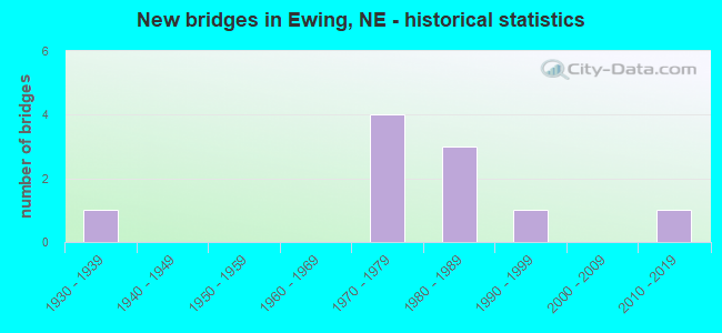
- New bridges - historical statistics
- 11930-1939
- 41970-1979
- 31980-1989
- 11990-1999
- 12010-2019

- Reconstructed bridges - Historical Statistics
- 21980-1989
- 01990-1999
- 12000-2009

- Bridge Condition - Deck
- 50.0%Very good
- 37.5%Good
- 12.5%Satisfactory

- Bridge Condition - Superstructure
- 12.5%Excellent
- 50.0%Very good
- 25.0%Good
- 12.5%Satisfactory

- Bridge Condition - Substructure
- 12.5%Excellent
- 25.0%Very good
- 62.5%Good

- Bridge Condition - Channel
- 10.0%Excellent
- 60.0%Very good
- 10.0%Good
- 20.0%Satisfactory
Find on map >> Show street view
Structure Number: C00450871, Location: JCT US275/L-45B .8S 3W (Lat: 42.241600, Lng: -98.398400), Route carried "on" structure: County highway 2260, Year Built: 1979, Status: Open, Structure Length: 3.41m (11.19ft), Average Daily Traffic: 95 (year 2011), Average Future Daily Traffic: 95 (year 2033), Features Intersected: S FK ELKHORN RIVER
Minimum Vertical Clearance: 30+ m (98+ ft), Kilometerpoint: 2.332, Lanes on structure: 2, Owner: County Highway Agency, Approaching Roadway Width: 8.5m (27.9ft), Material/Design: Prestressed concrete, Design/Construction: Tee Beam, Number Of Spans In Main Unit: 3, Length of Maximum Span: 12.5m (41.0ft), Curb-To-Curb Width: 8.5m (27.9ft), Out-to-Out Width: 9.2m (30.2ft)
Condition: Deck: Very good, Superstructure: Very good, Substructure: Good, Channel: Satisfactory, Operating Rating: 67.0 metric tons, Method Used To Determine Operating Rating: Load Factor (LF), Inventory Rating: 37.0 metric tons, Method Used To Determine Inventory Rating: Load Factor (LF), Structural Evaluation: Better than present minimum criteria, Deck Geometry: Better than present minimum criteria, Waterway Adequacy: Equal to present desirable criteria, Approach Roadway Alignment: Equal to present desirable criteria, Length Of Structure Improvement: 3.41m (11.19ft), Designated Inspection Frequency: Every 24 months, Inspection Date: August 2021, Deck Structure Type: Concrete Cast-file-Place, Wearing Surface/Protective System: Wearing Surface: Monolithic Concrete
Find on map >> Show street view
Structure Number: C00450931, Location: 2.7S OF EWING (Lat: 42.211600, Lng: -98.339600), Route carried "on" structure: County highway 7489, Year Built: 1998, Status: Open, Structure Length: 3.90m (12.80ft), Average Daily Traffic: 290 (year 1998), Average Future Daily Traffic: 493 (year 2033), Design Load: HS 20, Features Intersected: CACHE CREEK
Minimum Vertical Clearance: 30+ m (98+ ft), Kilometerpoint: 4.936, Lanes on structure: 2, Owner: County Highway Agency, Approaching Roadway Width: 9.1m (29.9ft), Material/Design: Concrete continuous, Design/Construction: Slab, Number Of Spans In Main Unit: 3, Length of Maximum Span: 15.2m (49.9ft), Curb or Sidewalk Widths: Left: 0.4m (1.3ft), Right: 0.4m (1.3ft), Curb-To-Curb Width: 8.5m (27.9ft), Out-to-Out Width: 9.2m (30.2ft)
Condition: Deck: Good, Superstructure: Very good, Substructure: Very good, Channel: Very good, Operating Rating: 66.0 metric tons, Method Used To Determine Operating Rating: Load Factor (LF), Inventory Rating: 36.0 metric tons, Method Used To Determine Inventory Rating: Load Factor (LF), Structural Evaluation: Equal to present desirable criteria, Deck Geometry: Equal to present minimum criteria, Waterway Adequacy: Better than present minimum criteria, Approach Roadway Alignment: Equal to present desirable criteria, Length Of Structure Improvement: 3.84m (12.60ft), Designated Inspection Frequency: Every 24 months, Inspection Date: August 2021, Deck Structure Type: Concrete Cast-file-Place, Wearing Surface/Protective System: Wearing Surface: Monolithic Concrete
Find on map >> Show street view
Structure Number: C004509315, Location: .5S EWING (Lat: 42.251000, Lng: -98.339500), Route carried "on" structure: County highway 7489, Year Built: 2014, Status: Open, Structure Length: 5.87m (19.26ft), Average Daily Traffic: 290 (year 1998), Average Future Daily Traffic: 290 (year 2033), Design Load: HL 93, Features Intersected: S FK ELKHORN RIVER
Minimum Vertical Clearance: 30+ m (98+ ft), Kilometerpoint: 5.398, Lanes on structure: 2, Owner: County Highway Agency, Approaching Roadway Width: 8.5m (27.9ft), Skew: 3 degrees, Material/Design: Prestressed concrete continuous, Design/Construction: Stringer/Multi-beam, Number Of Spans In Main Unit: 3, Length of Maximum Span: 23.2m (76.1ft), Curb or Sidewalk Widths: Left: 0.4m (1.3ft), Right: 0.4m (1.3ft), Curb-To-Curb Width: 8.5m (27.9ft), Out-to-Out Width: 9.2m (30.2ft)
Condition: Deck: Very good, Superstructure: Excellent, Substructure: Excellent, Channel: Excellent, Operating Rating: 53.0 metric tons, Method Used To Determine Operating Rating: Load and Resistance Factor (LRFR), Inventory Rating: 41.0 metric tons, Method Used To Determine Inventory Rating: Load and Resistance Factor (LRFR), Structural Evaluation: Superior to present desirable criteria, Deck Geometry: Equal to present minimum criteria, Waterway Adequacy: Equal to present desirable criteria, Approach Roadway Alignment: Equal to present desirable criteria, Length Of Structure Improvement: 4.57m (14.99ft), Designated Inspection Frequency: Every 24 months, Inspection Date: September 2020, Deck Structure Type: Concrete Cast-file-Place, Wearing Surface/Protective System: Wearing Surface: Monolithic Concrete, Deck Protection: Epoxy Coated Reinforcing
Find on map >> Show street view
Structure Number: C00455901, Location: .5S 1.2E OF EWING (Lat: 42.248400, Lng: -98.313500), Route carried "on" structure: County highway 7510, Year Built: 1988, Status: Open, Structure Length: 6.49m (21.29ft), Average Daily Traffic: 205 (year 1998), Average Future Daily Traffic: 205 (year 2033), Design Load: HS 20, Features Intersected: ELKHORN RIVER
Minimum Vertical Clearance: 30+ m (98+ ft), Kilometerpoint: 0.174, Lanes on structure: 2, Owner: County Highway Agency, Approaching Roadway Width: 6.7m (22.0ft), Skew: 1 degrees, Material/Design: Prestressed concrete, Design/Construction: Stringer/Multi-beam, Number Of Spans In Main Unit: 3, Length of Maximum Span: 22.6m (74.1ft), Curb or Sidewalk Widths: Left: 0.4m (1.3ft), Right: 0.4m (1.3ft), Curb-To-Curb Width: 8.5m (27.9ft), Out-to-Out Width: 9.3m (30.5ft)
Condition: Deck: Very good, Superstructure: Very good, Substructure: Very good, Channel: Satisfactory, Operating Rating: 65.0 metric tons, Method Used To Determine Operating Rating: Load Factor (LF), Inventory Rating: 39.0 metric tons, Method Used To Determine Inventory Rating: Load Factor (LF), Structural Evaluation: Equal to present desirable criteria, Deck Geometry: Equal to present minimum criteria, Waterway Adequacy: Equal to present desirable criteria, Approach Roadway Alignment: Equal to present desirable criteria, Designated Inspection Frequency: Every 24 months, Inspection Date: September 2020, Deck Structure Type: Concrete Cast-file-Place, Wearing Surface/Protective System: Wearing Surface: Monolithic Concrete
Find on map >> Show street view
Structure Number: S275 01781, Location: 3NW EWING (Lat: 42.288800, Lng: -98.389300), Route carried "on" structure: US 275, Year Built: 1937, Year Reconstructed: 2000, Status: Open, Structure Length: 1.10m (3.61ft), Average Daily Traffic: 1,840 (year 2018), Truck Traffic: 13%, Average Future Daily Traffic: 2,484 (year 2038), Design Load: HS 20, Features Intersected: STREAM
Minimum Vertical Clearance: 30+ m (98+ ft), Kilometerpoint: 2.866, Lanes on structure: 2, Base Highway Network: Yes, Owner: State Highway Agency, Approaching Roadway Width: 12.2m (40.0ft), Skew: 3 degrees, Material/Design: Concrete, Design/Construction: Culvert, Number Of Spans In Main Unit: 3, Length of Maximum Span: 3.0m (9.8ft)
Condition: Channel: Good, Culverts: Good, Operating Rating: 33.0 metric tons, Method Used To Determine Operating Rating: Field evaluation and documented engineering judgment, Inventory Rating: 22.0 metric tons, Method Used To Determine Inventory Rating: Field evaluation and documented engineering judgment, Structural Evaluation: Somewhat better than minimum adequacy, Waterway Adequacy: Equal to present desirable criteria, Approach Roadway Alignment: Equal to present desirable criteria, Designated Inspection Frequency: Every 24 months, Inspection Date: March 2021
Find on map >> Show street view
Structure Number: S275 02146, Location: 1E EWING (Lat: 42.251500, Lng: -98.338500), Route carried "on" structure: US 275, Year Built: 1979, Status: Open, Structure Length: 4.88m (16.01ft), Average Daily Traffic: 1,850 (year 2018), Truck Traffic: 14%, Average Future Daily Traffic: 2,405 (year 2038), Design Load: HS 20, Features Intersected: S FK ELKHORN RIVER
Minimum Vertical Clearance: 30+ m (98+ ft), Kilometerpoint: 3.454, Lanes on structure: 2, Base Highway Network: Yes, Owner: State Highway Agency, Approaching Roadway Width: 12.2m (40.0ft), Material/Design: Concrete continuous, Design/Construction: Slab, Number Of Spans In Main Unit: 5, Length of Maximum Span: 11.0m (36.1ft), Curb-To-Curb Width: 12.2m (40.0ft), Out-to-Out Width: 13.0m (42.7ft)
Condition: Deck: Good, Superstructure: Good, Substructure: Good, Channel: Very good, Operating Rating: 48.0 metric tons, Method Used To Determine Operating Rating: Load Factor (LF), Inventory Rating: 28.0 metric tons, Method Used To Determine Inventory Rating: Load Factor (LF), Structural Evaluation: Better than present minimum criteria, Deck Geometry: Better than present minimum criteria, Waterway Adequacy: Equal to present desirable criteria, Approach Roadway Alignment: Equal to present desirable criteria, Designated Inspection Frequency: Every 24 months, Inspection Date: March 2021, Deck Structure Type: Concrete Cast-file-Place, Wearing Surface/Protective System: Wearing Surface: Monolithic Concrete, Deck Protection: Epoxy Coated Reinforcing
Find on map >> Show street view
Structure Number: S275 0217, Location: 1E EWING (Lat: 42.249900, Lng: -98.336400), Route carried "on" structure: US 275, Year Built: 1979, Status: Open, Structure Length: 0.98m (3.22ft), Average Daily Traffic: 1,850 (year 2018), Truck Traffic: 14%, Average Future Daily Traffic: 2,405 (year 2038), Design Load: HS 20, Features Intersected: ELKHORN R S FK TRIB
Minimum Vertical Clearance: 30+ m (98+ ft), Kilometerpoint: 3.481, Lanes on structure: 2, Base Highway Network: Yes, Owner: State Highway Agency, Approaching Roadway Width: 12.2m (40.0ft), Material/Design: Concrete, Design/Construction: Culvert, Number Of Spans In Main Unit: 3, Length of Maximum Span: 3.0m (9.8ft)
Condition: Channel: Very good, Culverts: Good, Operating Rating: 43.0 metric tons, Method Used To Determine Operating Rating: Field evaluation and documented engineering judgment, Inventory Rating: 33.0 metric tons, Method Used To Determine Inventory Rating: Field evaluation and documented engineering judgment, Structural Evaluation: Better than present minimum criteria, Waterway Adequacy: Better than present minimum criteria, Approach Roadway Alignment: Equal to present desirable criteria, Designated Inspection Frequency: Every 24 months, Inspection Date: March 2021
Find on map >> Show street view
Structure Number: S275 02373, Location: 3E EWING (Lat: 42.228300, Lng: -98.307600), Route carried "on" structure: US 275, Year Built: 1979, Status: Open, Structure Length: 3.05m (10.01ft), Average Daily Traffic: 1,850 (year 2018), Truck Traffic: 14%, Average Future Daily Traffic: 2,405 (year 2038), Design Load: HS 20, Features Intersected: CACHE CREEK
Minimum Vertical Clearance: 30+ m (98+ ft), Kilometerpoint: 3.819, Lanes on structure: 2, Base Highway Network: Yes, Owner: State Highway Agency, Approaching Roadway Width: 12.2m (40.0ft), Material/Design: Concrete continuous, Design/Construction: Slab, Number Of Spans In Main Unit: 3, Length of Maximum Span: 12.2m (40.0ft), Curb-To-Curb Width: 12.2m (40.0ft), Out-to-Out Width: 13.0m (42.7ft)
Condition: Deck: Good, Superstructure: Good, Substructure: Good, Channel: Very good, Operating Rating: 50.0 metric tons, Method Used To Determine Operating Rating: Load Factor (LF), Inventory Rating: 30.0 metric tons, Method Used To Determine Inventory Rating: Load Factor (LF), Structural Evaluation: Better than present minimum criteria, Deck Geometry: Better than present minimum criteria, Waterway Adequacy: Equal to present desirable criteria, Approach Roadway Alignment: Equal to present desirable criteria, Designated Inspection Frequency: Every 24 months, Inspection Date: March 2021, Deck Structure Type: Concrete Cast-file-Place, Wearing Surface/Protective System: Wearing Surface: Monolithic Concrete, Deck Protection: Epoxy Coated Reinforcing
Find on map >> Show street view
Structure Number: SL45B00449, Location: 1N EWING (Lat: 42.268300, Lng: -98.339500), Route carried "on" structure: Spur State highway L45B, Year Built: 1982, Year Reconstructed: 1993, Status: Open, Structure Length: 5.43m (17.81ft), Average Daily Traffic: 390 (year 2018), Truck Traffic: 6%, Average Future Daily Traffic: 566 (year 2038), Design Load: HS 20, Features Intersected: ELKHORN RIVER
Minimum Vertical Clearance: 30+ m (98+ ft), Kilometerpoint: 0.747, Lanes on structure: 2, Owner: State Highway Agency, Approaching Roadway Width: 7.3m (24.0ft), Material/Design: Concrete continuous, Design/Construction: Slab, Number Of Spans In Main Unit: 4, Length of Maximum Span: 15.2m (49.9ft), Curb-To-Curb Width: 9.1m (29.9ft), Out-to-Out Width: 9.8m (32.2ft)
Condition: Deck: Satisfactory, Superstructure: Satisfactory, Substructure: Good, Channel: Very good, Operating Rating: 64.0 metric tons, Method Used To Determine Operating Rating: Load Factor (LF), Inventory Rating: 38.0 metric tons, Method Used To Determine Inventory Rating: Load Factor (LF), Structural Evaluation: Equal to present minimum criteria, Deck Geometry: Equal to present minimum criteria, Waterway Adequacy: Equal to present desirable criteria, Approach Roadway Alignment: Equal to present desirable criteria, Designated Inspection Frequency: Every 48 months, Inspection Date: March 2019, Deck Structure Type: Concrete Cast-file-Place, Wearing Surface/Protective System: Wearing Surface: Low Slump Concrete
Find on map >> Show street view
Structure Number: SL45B00473, Location: 1N EWING (Lat: 42.264800, Lng: -98.339500), Route carried "on" structure: Spur State highway L45B, Year Built: 1982, Year Reconstructed: 1993, Status: Open, Structure Length: 1.04m (3.41ft), Average Daily Traffic: 390 (year 2018), Truck Traffic: 6%, Average Future Daily Traffic: 566 (year 2038), Design Load: HS 20, Features Intersected: ELKHORN RIVER OVERFLOW
Minimum Vertical Clearance: 30+ m (98+ ft), Kilometerpoint: 0.785, Lanes on structure: 2, Owner: State Highway Agency, Approaching Roadway Width: 7.3m (24.0ft), Material/Design: Prestressed concrete, Design/Construction: Tee Beam, Number Of Spans In Main Unit: 1, Length of Maximum Span: 9.8m (32.2ft), Curb-To-Curb Width: 9.1m (29.9ft), Out-to-Out Width: 9.8m (32.2ft)
Condition: Deck: Very good, Superstructure: Very good, Substructure: Good, Channel: Very good, Operating Rating: 66.0 metric tons, Method Used To Determine Operating Rating: Load Factor (LF), Inventory Rating: 39.0 metric tons, Method Used To Determine Inventory Rating: Load Factor (LF), Structural Evaluation: Better than present minimum criteria, Deck Geometry: Equal to present minimum criteria, Waterway Adequacy: Equal to present desirable criteria, Approach Roadway Alignment: Equal to present desirable criteria, Designated Inspection Frequency: Every 48 months, Inspection Date: March 2019, Deck Structure Type: Concrete Cast-file-Place, Wearing Surface/Protective System: Wearing Surface: Low Slump Concrete