Bridge Statistics for Evanston, Wyoming (WY)
Condition, Traffic, Stress, Structural Evaluation, Project Costs
- National Bridge Inventory (NBI) Statistics
- 24Number of bridges
- 358ft / 109mTotal length
- $6,591,000Total costs
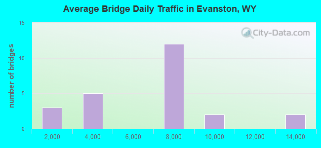
- 149,709Total average daily traffic
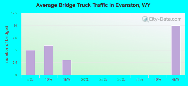
- 38,923Total average daily truck traffic
- National Bridge Inventory (NBI) Registered Bridges for Evanston
- No street view available for this location
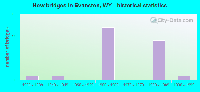
- New bridges - historical statistics
- 11930-1939
- 11940-1949
- 121960-1969
- 91980-1989
- 11990-1999
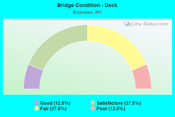
- Bridge Condition - Deck
- 12.5%Good
- 37.5%Satisfactory
- 37.5%Fair
- 12.5%Poor
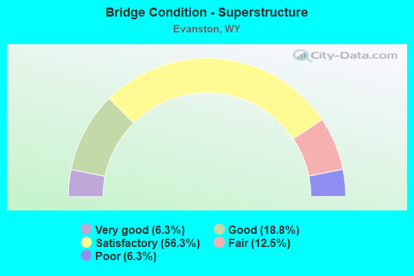
- Bridge Condition - Superstructure
- 6.3%Very good
- 18.8%Good
- 56.3%Satisfactory
- 12.5%Fair
- 6.3%Poor
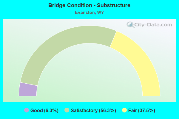
- Bridge Condition - Substructure
- 6.3%Good
- 56.3%Satisfactory
- 37.5%Fair
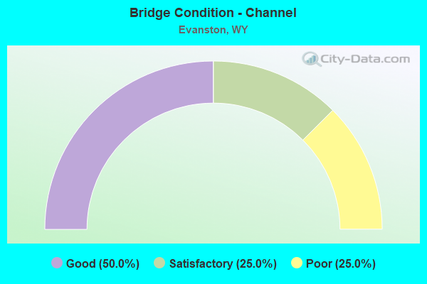
- Bridge Condition - Channel
- 50.0%Good
- 25.0%Satisfactory
- 25.0%Poor
Find on map >> Show street view
Structure Number: AMF, Location: Utah Line - Evanston (Lat: 41.260508, Lng: -110.986108), Route carried "on" structure: Interstate 80, Year Built: 1967, Status: Open, Structure Length: 5.84m (19.16ft), Average Daily Traffic: 8,674 (year 2021), Truck Traffic: 42%, Average Future Daily Traffic: 12,144 (year 2041), Design Load: HS 20+Mod, Features Intersected: Harrison Drive
Minimum Vertical Clearance: 30+ m (98+ ft), Kilometerpoint: 5.515, Lanes on structure: 2, Lanes under structure: 4, Base Highway Network: Yes, Owner: State Highway Agency, Approaching Roadway Width: 11.6m (38.1ft), Skew: 14 degrees, Material/Design: Steel continuous, Design/Construction: Stringer/Multi-beam, Number Of Spans In Main Unit: 3, Length of Maximum Span: 23.8m (78.1ft), Curb-To-Curb Width: 11.6m (38.1ft), Out-to-Out Width: 12.4m (40.7ft)
Condition: Deck: Fair, Superstructure: Satisfactory, Substructure: Fair, Operating Rating: 39.6 metric tons, Method Used To Determine Operating Rating: Load Factor (LF), Inventory Rating: 23.9 metric tons, Method Used To Determine Inventory Rating: Load Factor (LF), Structural Evaluation: Somewhat better than minimum adequacy, Deck Geometry: Equal to present minimum criteria, Underclear: High priority of replacement, Approach Roadway Alignment: Equal to present desirable criteria, Length Of Structure Improvement: 8.38m (27.49ft), Designated Inspection Frequency: Every 24 months, Inspection Date: July 2021, Bridge Improvement Cost: $822,000, Roadway Improvement Cost: $82,000, Total Project Cost: $1,232,000, Deck Structure Type: Concrete Cast-file-Place, Wearing Surface/Protective System: Wearing Surface: Epoxy Overlay, Deck Protection: Galvanized Reinforcing
Find on map >> Show street view
Structure Number: AMG, Location: Evanston (Lat: 41.261089, Lng: -110.985933), Route carried "on" structure: Interstate 80, Year Built: 1967, Status: Open, Structure Length: 5.84m (19.16ft), Average Daily Traffic: 7,827 (year 2021), Truck Traffic: 44%, Average Future Daily Traffic: 10,958 (year 2041), Design Load: HS 20+Mod, Features Intersected: Harrison Drive
Minimum Vertical Clearance: 30+ m (98+ ft), Kilometerpoint: 5.538, Lanes on structure: 2, Lanes under structure: 4, Base Highway Network: Yes, Owner: State Highway Agency, Approaching Roadway Width: 11.6m (38.1ft), Skew: 14 degrees, Material/Design: Steel continuous, Design/Construction: Stringer/Multi-beam, Number Of Spans In Main Unit: 3, Length of Maximum Span: 23.8m (78.1ft), Curb-To-Curb Width: 10.1m (33.1ft), Out-to-Out Width: 12.4m (40.7ft)
Condition: Deck: Good, Superstructure: Good, Substructure: Satisfactory, Operating Rating: 53.5 metric tons, Method Used To Determine Operating Rating: Load Factor (LF), Inventory Rating: 32.0 metric tons, Method Used To Determine Inventory Rating: Load Factor (LF), Structural Evaluation: Equal to present minimum criteria, Deck Geometry: High priority of corrective action, Underclear: High priority of corrective action, Approach Roadway Alignment: Equal to present desirable criteria, Length Of Structure Improvement: 2.44m (8.01ft), Designated Inspection Frequency: Every 24 months, Inspection Date: July 2021, Bridge Improvement Cost: $1,000, Roadway Improvement Cost: $1,000, Total Project Cost: $3,000, Deck Structure Type: Concrete Cast-file-Place
Find on map >> Show street view
Structure Number: AMH, Location: Evanston (Lat: 41.258133, Lng: -110.967486), Route carried "on" structure: Interstate 80, Year Built: 1967, Status: Open, Structure Length: 2.80m (9.19ft), Average Daily Traffic: 7,640 (year 2021), Truck Traffic: 44%, Average Future Daily Traffic: 10,696 (year 2041), Design Load: HS 20+Mod, Features Intersected: Yellow Creek Road
Minimum Vertical Clearance: 30+ m (98+ ft), Kilometerpoint: 7.239, Lanes on structure: 2, Lanes under structure: 2, Base Highway Network: Yes, Owner: State Highway Agency, Approaching Roadway Width: 11.6m (38.1ft), Skew: 10 degrees, Material/Design: Concrete continuous, Design/Construction: Tee Beam, Number Of Spans In Main Unit: 3, Length of Maximum Span: 11.3m (37.1ft), Curb-To-Curb Width: 11.6m (38.1ft), Out-to-Out Width: 12.4m (40.7ft)
Condition: Deck: Fair, Superstructure: Poor, Substructure: Fair, Operating Rating: 59.0 metric tons, Method Used To Determine Operating Rating: Load Factor (LF), Inventory Rating: 35.4 metric tons, Method Used To Determine Inventory Rating: Load Factor (LF), Structural Evaluation: Meets minimum limits, Deck Geometry: Equal to present minimum criteria, Underclear: High priority of corrective action, Approach Roadway Alignment: Equal to present desirable criteria, Length Of Structure Improvement: 2.80m (9.19ft), Designated Inspection Frequency: Every 24 months, Inspection Date: July 2021, Bridge Improvement Cost: $95,000, Roadway Improvement Cost: $11,000, Total Project Cost: $115,000, Deck Structure Type: Concrete Cast-file-Place, Wearing Surface/Protective System: Wearing Surface: Latex Concrete
Find on map >> Show street view
Structure Number: AMI, Location: Evanston (Lat: 41.258286, Lng: -110.967489), Route carried "on" structure: Interstate 80, Year Built: 1967, Status: Open, Structure Length: 2.80m (9.19ft), Average Daily Traffic: 7,827 (year 2021), Truck Traffic: 44%, Average Future Daily Traffic: 10,958 (year 2041), Design Load: HS 20+Mod, Features Intersected: Yellow Creek Road
Minimum Vertical Clearance: 30+ m (98+ ft), Kilometerpoint: 7.248, Lanes on structure: 2, Lanes under structure: 2, Base Highway Network: Yes, Owner: State Highway Agency, Approaching Roadway Width: 11.6m (38.1ft), Skew: 10 degrees, Material/Design: Concrete continuous, Design/Construction: Tee Beam, Number Of Spans In Main Unit: 3, Length of Maximum Span: 11.3m (37.1ft), Curb-To-Curb Width: 11.6m (38.1ft), Out-to-Out Width: 12.4m (40.7ft)
Condition: Deck: Fair, Superstructure: Fair, Substructure: Fair, Operating Rating: 59.0 metric tons, Method Used To Determine Operating Rating: Load Factor (LF), Inventory Rating: 35.4 metric tons, Method Used To Determine Inventory Rating: Load Factor (LF), Structural Evaluation: Somewhat better than minimum adequacy, Deck Geometry: Equal to present minimum criteria, Underclear: High priority of corrective action, Approach Roadway Alignment: Equal to present desirable criteria, Length Of Structure Improvement: 2.44m (8.01ft), Designated Inspection Frequency: Every 24 months, Inspection Date: July 2021, Bridge Improvement Cost: $1,000, Roadway Improvement Cost: $1,000, Total Project Cost: $3,000, Deck Structure Type: Concrete Cast-file-Place, Wearing Surface/Protective System: Wearing Surface: Epoxy Overlay
Find on map >> Show street view
Structure Number: AML, Location: Evanston (Lat: 41.267353, Lng: -110.945917), Route carried "on" structure: Interstate 80, Year Built: 1967, Year Reconstructed: 1986, Status: Open, Structure Length: 12.62m (41.40ft), Average Daily Traffic: 7,640 (year 2021), Truck Traffic: 44%, Average Future Daily Traffic: 10,696 (year 2041), Design Load: HS 20+Mod, Features Intersected: UPRR / Bear River
Minimum Vertical Clearance: 30+ m (98+ ft), Kilometerpoint: 9.450, Lanes on structure: 2, Base Highway Network: Yes, Owner: State Highway Agency, Approaching Roadway Width: 12.2m (40.0ft), Skew: 14 degrees, Material/Design: Steel continuous, Design/Construction: Stringer/Multi-beam, Number Of Spans In Main Unit: 4, Length of Maximum Span: 36.6m (120.1ft), Curb-To-Curb Width: 12.2m (40.0ft), Out-to-Out Width: 13.0m (42.7ft)
Condition: Deck: Fair, Superstructure: Satisfactory, Substructure: Satisfactory, Channel: Poor, Operating Rating: 49.9 metric tons, Method Used To Determine Operating Rating: Load Factor (LF), Inventory Rating: 29.9 metric tons, Method Used To Determine Inventory Rating: Load Factor (LF), Structural Evaluation: Equal to present minimum criteria, Deck Geometry: Better than present minimum criteria, Underclear: Somewhat better than minimum adequacy, Waterway Adequacy: Superior to present desirable criteria, Approach Roadway Alignment: Equal to present minimum criteria, Length Of Structure Improvement: 12.62m (41.40ft), Designated Inspection Frequency: Every 24 months, Inspection Date: July 2021, Bridge Improvement Cost: $322,000, Roadway Improvement Cost: $32,000, Total Project Cost: $483,000, Deck Structure Type: Concrete Cast-file-Place, Wearing Surface/Protective System: Wearing Surface: Epoxy Overlay
Find on map >> Show street view
Structure Number: AMM, Location: Evanston (Lat: 41.267478, Lng: -110.946128), Route carried "on" structure: Interstate 80, Year Built: 1967, Year Reconstructed: 1986, Status: Open, Structure Length: 12.62m (41.40ft), Average Daily Traffic: 8,650 (year 2021), Truck Traffic: 44%, Average Future Daily Traffic: 12,110 (year 2041), Design Load: HS 20+Mod, Features Intersected: UPRR / Bear River
Minimum Vertical Clearance: 30+ m (98+ ft), Kilometerpoint: 9.442, Lanes on structure: 2, Base Highway Network: Yes, Owner: State Highway Agency, Approaching Roadway Width: 14.3m (46.9ft), Skew: 14 degrees, Material/Design: Steel continuous, Design/Construction: Stringer/Multi-beam, Number Of Spans In Main Unit: 4, Length of Maximum Span: 36.6m (120.1ft), Curb-To-Curb Width: 14.3m (46.9ft), Out-to-Out Width: 15.2m (49.9ft)
Condition: Deck: Satisfactory, Superstructure: Satisfactory, Substructure: Satisfactory, Channel: Poor, Operating Rating: 50.8 metric tons, Method Used To Determine Operating Rating: Load Factor (LF), Inventory Rating: 29.9 metric tons, Method Used To Determine Inventory Rating: Load Factor (LF), Structural Evaluation: Equal to present minimum criteria, Deck Geometry: Superior to present desirable criteria, Underclear: Somewhat better than minimum adequacy, Waterway Adequacy: Superior to present desirable criteria, Approach Roadway Alignment: Equal to present desirable criteria, Length Of Structure Improvement: 13.56m (44.49ft), Designated Inspection Frequency: Every 24 months, Inspection Date: July 2021, Bridge Improvement Cost: $2,216,000, Roadway Improvement Cost: $222,000, Total Project Cost: $3,324,000 ( Estimate for 2014), Deck Structure Type: Concrete Cast-file-Place, Wearing Surface/Protective System: Wearing Surface: Epoxy Overlay
Find on map >> Show street view
Structure Number: AMN, Location: Evanston (Lat: 41.267878, Lng: -110.938928), Route carried "on" structure: Interstate 80, Year Built: 1966, Status: Open, Structure Length: 5.58m (18.31ft), Average Daily Traffic: 7,640 (year 2021), Truck Traffic: 44%, Average Future Daily Traffic: 10,696 (year 2041), Design Load: HS 20+Mod, Features Intersected: Bear River Drive
Minimum Vertical Clearance: 30+ m (98+ ft), Kilometerpoint: 10.037, Lanes on structure: 2, Lanes under structure: 4, Base Highway Network: Yes, Owner: State Highway Agency, Approaching Roadway Width: 11.6m (38.1ft), Skew: 13 degrees, Material/Design: Steel continuous, Design/Construction: Stringer/Multi-beam, Number Of Spans In Main Unit: 3, Length of Maximum Span: 22.6m (74.1ft), Curb-To-Curb Width: 11.6m (38.1ft), Out-to-Out Width: 12.6m (41.3ft)
Condition: Deck: Satisfactory, Superstructure: Good, Substructure: Satisfactory, Operating Rating: 49.0 metric tons, Method Used To Determine Operating Rating: Load Factor (LF), Inventory Rating: 29.0 metric tons, Method Used To Determine Inventory Rating: Load Factor (LF), Structural Evaluation: Equal to present minimum criteria, Deck Geometry: Equal to present minimum criteria, Underclear: High priority of corrective action, Approach Roadway Alignment: Equal to present desirable criteria, Designated Inspection Frequency: Every 24 months, Inspection Date: July 2021, Deck Structure Type: Concrete Cast-file-Place
Find on map >> Show street view
Structure Number: AMO, Location: Evanston (Lat: 41.268047, Lng: -110.939103), Route carried "on" structure: Interstate 80, Year Built: 1966, Status: Open, Structure Length: 5.58m (18.31ft), Average Daily Traffic: 7,827 (year 2021), Truck Traffic: 44%, Average Future Daily Traffic: 10,958 (year 2041), Design Load: HS 20+Mod, Features Intersected: Bear River Drive
Minimum Vertical Clearance: 30+ m (98+ ft), Kilometerpoint: 10.034, Lanes on structure: 2, Lanes under structure: 4, Base Highway Network: Yes, Owner: State Highway Agency, Approaching Roadway Width: 11.6m (38.1ft), Skew: 13 degrees, Material/Design: Concrete continuous, Design/Construction: Stringer/Multi-beam, Number Of Spans In Main Unit: 3, Length of Maximum Span: 22.6m (74.1ft), Curb-To-Curb Width: 11.6m (38.1ft), Out-to-Out Width: 12.5m (41.0ft)
Condition: Deck: Fair, Superstructure: Satisfactory, Substructure: Fair, Operating Rating: 49.0 metric tons, Method Used To Determine Operating Rating: Load Factor (LF), Inventory Rating: 29.0 metric tons, Method Used To Determine Inventory Rating: Load Factor (LF), Structural Evaluation: Somewhat better than minimum adequacy, Deck Geometry: Equal to present minimum criteria, Underclear: High priority of corrective action, Approach Roadway Alignment: Equal to present desirable criteria, Length Of Structure Improvement: 3.66m (12.01ft), Designated Inspection Frequency: Every 24 months, Inspection Date: July 2021, Bridge Improvement Cost: $50,000, Roadway Improvement Cost: $1,000, Total Project Cost: $56,000, Deck Structure Type: Concrete Cast-file-Place, Wearing Surface/Protective System: Wearing Surface: Epoxy Overlay
Find on map >> Show street view
Structure Number: BJV, Location: Evanston (Lat: 41.270353, Lng: -110.960839), Route carried "on" structure: Business US 80, Year Built: 1941, Status: Open, Structure Length: 5.24m (17.19ft), Average Daily Traffic: 3,052 (year 2021), Truck Traffic: 6%, Average Future Daily Traffic: 4,273 (year 2041), Design Load: H 15, Features Intersected: Bear River, Facility Carried by Structure: Bear River Drive
Minimum Vertical Clearance: 30+ m (98+ ft), Kilometerpoint: 161.221, Lanes on structure: 2, Owner: Town or Township Highway Agency, Approaching Roadway Width: 9.1m (29.9ft), Skew: 4 degrees, Material/Design: Concrete, Design/Construction: Stringer/Multi-beam, Number Of Spans In Main Unit: 4, Length of Maximum Span: 13.1m (43.0ft), Curb or Sidewalk Widths: Left: 1.4m (4.6ft), Right: 1.4m (4.6ft), Curb-To-Curb Width: 9.1m (29.9ft), Out-to-Out Width: 13.4m (44.0ft)
Condition: Deck: Fair, Superstructure: Fair, Substructure: Fair, Channel: Good, Operating Rating: 64.3 metric tons, Method Used To Determine Operating Rating: Allowable Stress (AS), Inventory Rating: 38.6 metric tons, Method Used To Determine Inventory Rating: Allowable Stress (AS), Structural Evaluation: Somewhat better than minimum adequacy, Deck Geometry: Meets minimum limits, Waterway Adequacy: Equal to present desirable criteria, Approach Roadway Alignment: Equal to present desirable criteria, Length Of Structure Improvement: 6.22m (20.41ft), Designated Inspection Frequency: Every 24 months, Inspection Date: July 2020, Bridge Improvement Cost: $899,000, Roadway Improvement Cost: $90,000, Total Project Cost: $1,348,000, Deck Structure Type: Concrete Cast-file-Place
Find on map >> Show street view
Structure Number: FEM, Location: Evanston (Lat: 41.266744, Lng: -110.959617), Route carried "on" structure: Business US 80, Year Built: 1984, Status: Open, Structure Length: 20.39m (66.90ft), Average Daily Traffic: 13,177 (year 2021), Truck Traffic: 6%, Average Future Daily Traffic: 18,448 (year 2041), Design Load: HS 20, Features Intersected: UPRR
Minimum Vertical Clearance: 30+ m (98+ ft), Kilometerpoint: 8.420, Lanes on structure: 4, Owner: State Highway Agency, Approaching Roadway Width: 16.2m (53.1ft), Skew: 2 degrees, Material/Design: Steel continuous, Design/Construction: Stringer/Multi-beam, Number Of Spans In Main Unit: 5, Length of Maximum Span: 53.3m (174.9ft), Curb or Sidewalk Widths: Left: 1.8m (5.9ft), Right: 0.0m, Curb-To-Curb Width: 15.8m (51.8ft), Out-to-Out Width: 18.8m (61.7ft)
Condition: Deck: Poor, Superstructure: Satisfactory, Substructure: Satisfactory, Operating Rating: 76.2 metric tons, Method Used To Determine Operating Rating: Load Factor (LF), Inventory Rating: 45.4 metric tons, Method Used To Determine Inventory Rating: Load Factor (LF), Structural Evaluation: Equal to present minimum criteria, Deck Geometry: Meets minimum limits, Underclear: Superior to present desirable criteria, Approach Roadway Alignment: Equal to present desirable criteria, Length Of Structure Improvement: 1.52m (4.99ft), Designated Inspection Frequency: Every 24 months, Inspection Date: July 2020, Bridge Improvement Cost: $13,000, Roadway Improvement Cost: $1,000, Total Project Cost: $15,000, Deck Structure Type: Concrete Cast-file-Place, Wearing Surface/Protective System: Wearing Surface: Epoxy Overlay, Deck Protection: Epoxy Coated Reinforcing
Find on map >> Show street view
Structure Number: FEN, Location: Evanston (Lat: 41.270164, Lng: -110.957722), Route carried "on" structure: Business US 80, Year Built: 1984, Status: Open, Structure Length: 6.16m (20.21ft), Average Daily Traffic: 13,177 (year 2021), Truck Traffic: 6%, Average Future Daily Traffic: 18,448 (year 2041), Design Load: HS 20, Features Intersected: Bear River
Minimum Vertical Clearance: 30+ m (98+ ft), Kilometerpoint: 8.837, Lanes on structure: 5, Owner: State Highway Agency, Approaching Roadway Width: 18.3m (60.0ft), Material/Design: Steel continuous, Design/Construction: Stringer/Multi-beam, Number Of Spans In Main Unit: 3, Length of Maximum Span: 24.1m (79.1ft), Curb or Sidewalk Widths: Left: 1.5m (4.9ft), Right: 0.0m, Curb-To-Curb Width: 18.3m (60.0ft), Out-to-Out Width: 21.3m (69.9ft)
Condition: Deck: Satisfactory, Superstructure: Satisfactory, Substructure: Satisfactory, Channel: Good, Operating Rating: 72.6 metric tons, Method Used To Determine Operating Rating: Load Factor (LF), Inventory Rating: 42.6 metric tons, Method Used To Determine Inventory Rating: Load Factor (LF), Structural Evaluation: Equal to present minimum criteria, Deck Geometry: High priority of replacement, Waterway Adequacy: Equal to present desirable criteria, Approach Roadway Alignment: Equal to present desirable criteria, Designated Inspection Frequency: Every 24 months, Inspection Date: July 2021, Deck Structure Type: Concrete Cast-file-Place, Wearing Surface/Protective System: Wearing Surface: Latex Concrete, Deck Protection: Epoxy Coated Reinforcing
Find on map >> Show street view
Structure Number: FFJ, Location: I-80-Business (Lat: 41.266561, Lng: -110.937314), Route carried "on" structure: US 51, Year Built: 1987, Status: Open, Structure Length: 1.07m (3.51ft), Average Daily Traffic: 698 (year 2021), Truck Traffic: 3%, Average Future Daily Traffic: 977 (year 2041), Design Load: HS 20, Features Intersected: Duncomb Hollow, Facility Carried by Structure: I-80 Bus.
Minimum Vertical Clearance: 30+ m (98+ ft), Kilometerpoint: 10.895, Lanes on structure: 2, Base Highway Network: Yes (Inventory Route: ML5, Subroute: 1), Owner: State Highway Agency, Approaching Roadway Width: 9.8m (32.2ft), Skew: 5 degrees, Material/Design: Concrete, Design/Construction: Culvert, Number Of Spans In Main Unit: 2, Length of Maximum Span: 3.0m (9.8ft)
Condition: Channel: Satisfactory, Culverts: Satisfactory, Operating Rating: 32.7 metric tons, Method Used To Determine Operating Rating: Field evaluation and documented engineering judgment, Inventory Rating: 32.7 metric tons, Method Used To Determine Inventory Rating: Field evaluation and documented engineering judgment, Structural Evaluation: Equal to present minimum criteria, Waterway Adequacy: Equal to present desirable criteria, Approach Roadway Alignment: Equal to present desirable criteria, Designated Inspection Frequency: Every 24 months, Inspection Date: July 2020
Find on map >> Show street view
Structure Number: FGR, Location: Evanston (Lat: 41.261864, Lng: -110.954628), Route carried "on" structure: Interstate 80, Year Built: 1986, Status: Open, Structure Length: 7.01m (23.00ft), Average Daily Traffic: 7,640 (year 2021), Truck Traffic: 44%, Average Future Daily Traffic: 10,696 (year 2041), Design Load: HS 20+Mod, Features Intersected: WYO 150
Minimum Vertical Clearance: 30+ m (98+ ft), Kilometerpoint: 8.439, Lanes on structure: 2, Lanes under structure: 5, Base Highway Network: Yes, Owner: State Highway Agency, Approaching Roadway Width: 12.8m (42.0ft), Skew: 3 degrees, Material/Design: Steel continuous, Design/Construction: Stringer/Multi-beam, Number Of Spans In Main Unit: 3, Length of Maximum Span: 35.7m (117.1ft), Curb-To-Curb Width: 12.8m (42.0ft), Out-to-Out Width: 13.7m (44.9ft)
Condition: Deck: Satisfactory, Superstructure: Satisfactory, Substructure: Satisfactory, Operating Rating: 83.6 metric tons, Method Used To Determine Operating Rating: Load Factor (LF), Inventory Rating: 47.4 metric tons, Method Used To Determine Inventory Rating: Load Factor (LF), Structural Evaluation: Equal to present minimum criteria, Deck Geometry: Equal to present desirable criteria, Underclear: High priority of corrective action, Approach Roadway Alignment: Equal to present desirable criteria, Designated Inspection Frequency: Every 24 months, Inspection Date: July 2021, Deck Structure Type: Concrete Cast-file-Place, Wearing Surface/Protective System: Wearing Surface: Epoxy Overlay, Deck Protection: Epoxy Coated Reinforcing
Find on map >> Show street view
Structure Number: FGS, Location: Evanston (Lat: 41.261872, Lng: -110.954858), Route carried "on" structure: Interstate 80, Year Built: 1986, Status: Open, Structure Length: 7.01m (23.00ft), Average Daily Traffic: 7,827 (year 2021), Truck Traffic: 44%, Average Future Daily Traffic: 10,958 (year 2041), Design Load: HS 20+Mod, Features Intersected: WYO 150
Minimum Vertical Clearance: 30+ m (98+ ft), Kilometerpoint: 8.420, Lanes on structure: 2, Lanes under structure: 5, Base Highway Network: Yes, Owner: State Highway Agency, Approaching Roadway Width: 11.6m (38.1ft), Skew: 3 degrees, Material/Design: Steel continuous, Design/Construction: Stringer/Multi-beam, Number Of Spans In Main Unit: 3, Length of Maximum Span: 35.7m (117.1ft), Curb-To-Curb Width: 12.8m (42.0ft), Out-to-Out Width: 13.7m (44.9ft)
Condition: Deck: Poor, Superstructure: Satisfactory, Substructure: Fair, Operating Rating: 83.6 metric tons, Method Used To Determine Operating Rating: Load Factor (LF), Inventory Rating: 47.4 metric tons, Method Used To Determine Inventory Rating: Load Factor (LF), Structural Evaluation: Somewhat better than minimum adequacy, Deck Geometry: Equal to present desirable criteria, Underclear: High priority of corrective action, Approach Roadway Alignment: Equal to present desirable criteria, Designated Inspection Frequency: Every 24 months, Inspection Date: July 2021, Deck Structure Type: Concrete Cast-file-Place, Wearing Surface/Protective System: Deck Protection: Epoxy Coated Reinforcing
Find on map >> Show street view
Structure Number: FJI, Location: Evanston (Lat: 41.269939, Lng: -110.963239), Route carried "on" structure: City street 4860, Year Built: 1988, Status: Open, Structure Length: 2.83m (9.28ft), Average Daily Traffic: 3,617 (year 2021), Truck Traffic: 10%, Average Future Daily Traffic: 5,064 (year 2041), Design Load: HS 20, Features Intersected: Bear River, Facility Carried by Structure: Ui Cnty Rd
Minimum Vertical Clearance: 30+ m (98+ ft), Kilometerpoint: 161.124, Lanes on structure: 2, Owner: Town or Township Highway Agency, Approaching Roadway Width: 11.9m (39.0ft), Skew: 1 degrees, Material/Design: Prestressed concrete, Design/Construction: Box Beam or Girders - Multiple, Number Of Spans In Main Unit: 1, Length of Maximum Span: 27.4m (89.9ft), Curb-To-Curb Width: 14.8m (48.6ft), Out-to-Out Width: 17.2m (56.4ft)
Condition: Deck: Satisfactory, Superstructure: Satisfactory, Substructure: Satisfactory, Channel: Good, Operating Rating: 39.9 metric tons, Method Used To Determine Operating Rating: Allowable Stress (AS), Inventory Rating: 35.4 metric tons, Method Used To Determine Inventory Rating: Allowable Stress (AS), Structural Evaluation: Equal to present minimum criteria, Deck Geometry: Superior to present desirable criteria, Waterway Adequacy: Equal to present desirable criteria, Approach Roadway Alignment: Equal to present desirable criteria, Length Of Structure Improvement: 4.21m (13.81ft), Designated Inspection Frequency: Every 24 months, Inspection Date: July 2020, Bridge Improvement Cost: $1,000, Roadway Improvement Cost: $5,000, Total Project Cost: $7,000, Deck Structure Type: Concrete Precast Panels, Wearing Surface/Protective System: Wearing Surface: Bituminous, Deck Protection: Epoxy Coated Reinforcing
Find on map >> Show street view
Structure Number: FKM, Location: 5 Mo N Of Evanston (Lat: 41.314597, Lng: -111.010961), Route carried "on" structure: County highway 105, Year Built: 1987, Status: Open, Structure Length: 2.83m (9.28ft), Average Daily Traffic: 314 (year 2021), Truck Traffic: 5%, Average Future Daily Traffic: 440 (year 2041), Design Load: HS 20, Features Intersected: Bear River
Minimum Vertical Clearance: 30+ m (98+ ft), Kilometerpoint: 0.497, Lanes on structure: 2, Owner: County Highway Agency, Approaching Roadway Width: 7.3m (24.0ft), Skew: 1 degrees, Material/Design: Prestressed concrete, Design/Construction: Stringer/Multi-beam, Number Of Spans In Main Unit: 1, Length of Maximum Span: 27.4m (89.9ft), Curb-To-Curb Width: 8.5m (27.9ft), Out-to-Out Width: 9.4m (30.8ft)
Condition: Deck: Satisfactory, Superstructure: Very good, Substructure: Satisfactory, Channel: Satisfactory, Operating Rating: 65.3 metric tons, Method Used To Determine Operating Rating: Allowable Stress (AS), Inventory Rating: 39.0 metric tons, Method Used To Determine Inventory Rating: Allowable Stress (AS), Structural Evaluation: Equal to present minimum criteria, Deck Geometry: Equal to present minimum criteria, Waterway Adequacy: Equal to present desirable criteria, Approach Roadway Alignment: Equal to present desirable criteria, Length Of Structure Improvement: 0.76m (2.49ft), Designated Inspection Frequency: Every 24 months, Inspection Date: July 2020, Bridge Improvement Cost: $1,000, Roadway Improvement Cost: $3,000, Total Project Cost: $5,000, Deck Structure Type: Concrete Cast-file-Place, Wearing Surface/Protective System: Deck Protection: Epoxy Coated Reinforcing
Find on map >> Show street view
Structure Number: KVK, Location: Evanston Streets (Lat: 41.273842, Lng: -110.966531), Route carried "on" structure: City street 4862, Year Built: 1997, Status: Open, Structure Length: 2.90m (9.51ft), Average Daily Traffic: 1,432 (year 2021), Truck Traffic: 9%, Average Future Daily Traffic: 2,005 (year 2041), Design Load: HS 25 or greater, Features Intersected: Bear River, Facility Carried by Structure: Holland Drive
Minimum Vertical Clearance: 30+ m (98+ ft), Kilometerpoint: 161.243, Lanes on structure: 2, Owner: Town or Township Highway Agency, Approaching Roadway Width: 11.9m (39.0ft), Material/Design: Steel continuous, Design/Construction: Stringer/Multi-beam, Number Of Spans In Main Unit: 3, Length of Maximum Span: 11.8m (38.7ft), Curb-To-Curb Width: 11.9m (39.0ft), Out-to-Out Width: 16.5m (54.1ft)
Condition: Deck: Good, Superstructure: Good, Substructure: Good, Channel: Good, Operating Rating: 89.8 metric tons, Method Used To Determine Operating Rating: Load Factor (LF), Inventory Rating: 58.1 metric tons, Method Used To Determine Inventory Rating: Load Factor (LF), Structural Evaluation: Better than present minimum criteria, Deck Geometry: Equal to present minimum criteria, Waterway Adequacy: Equal to present desirable criteria, Approach Roadway Alignment: Equal to present desirable criteria, Designated Inspection Frequency: Every 24 months, Inspection Date: July 2020, Deck Structure Type: Concrete Cast-file-Place
Find on map >> Show street view
Structure Number: AMF, Location: Utah Line - Evanston (Lat: 41.260508, Lng: -110.986108), Route carried "under" structure: Business US 51, Year Built: 1967, Structure Length: 0. m, Average Daily Traffic: 7,167 (year 2021), Truck Traffic: 10%, Features Intersected: Harrison Drive, Facility Carried by Structure: I-80 EBL
Minimum Vertical Clearance: 5.48m (17.98ft), Kilometerpoint: 5.509, Lanes on structure: 2, Lanes under structure: 4, Material/Design: Steel continuous, Design/Construction: Stringer/Multi-beam, Length of Maximum Span: 23.8m (78.1ft)
Find on map >> Show street view
Structure Number: AMG, Location: Evanston (Lat: 41.261089, Lng: -110.985933), Route carried "under" structure: Business US 51, Year Built: 1967, Structure Length: 0. m, Average Daily Traffic: 7,167 (year 2021), Truck Traffic: 10%, Features Intersected: Harrison Drive, Facility Carried by Structure: I-80 WBL
Minimum Vertical Clearance: 5.49m (18.01ft), Kilometerpoint: 5.576, Lanes on structure: 2, Lanes under structure: 4, Material/Design: Steel continuous, Design/Construction: Stringer/Multi-beam, Length of Maximum Span: 23.8m (78.1ft)
Find on map >> Show street view
Structure Number: AMN, Location: Evanston (Lat: 41.267878, Lng: -110.938928), Route carried "under" structure: Business US 51, Year Built: 1966, Structure Length: 0. m, Average Daily Traffic: 2,025 (year 2021), Truck Traffic: 2%, Features Intersected: Bear River Drive, Facility Carried by Structure: I-80 EBL
Minimum Vertical Clearance: 5.22m (17.13ft), Kilometerpoint: 10.697, Lanes on structure: 2, Lanes under structure: 4, Material/Design: Steel continuous, Design/Construction: Stringer/Multi-beam, Length of Maximum Span: 22.6m (74.1ft)
Find on map >> Show street view
Structure Number: AMO, Location: Evanston (Lat: 41.268047, Lng: -110.939103), Route carried "under" structure: Business US 51, Year Built: 1966, Structure Length: 0. m, Average Daily Traffic: 2,025 (year 2021), Truck Traffic: 2%, Features Intersected: Bear River Drive, Facility Carried by Structure: I-80 WBL
Minimum Vertical Clearance: 5.61m (18.41ft), Kilometerpoint: 10.673, Lanes on structure: 2, Lanes under structure: 4, Material/Design: Concrete continuous, Design/Construction: Stringer/Multi-beam, Length of Maximum Span: 22.6m (74.1ft)
Find on map >> Show street view
Structure Number: BJU, Location: Evanston (Lat: 41.268375, Lng: -110.963281), Route carried "under" structure: Business City street , Year Built: 1937, Structure Length: 0. m, Average Daily Traffic: 3,154 (year 2021), Truck Traffic: 6%, Features Intersected: Bear River Drive, Facility Carried by Structure: UPRR
Minimum Vertical Clearance: 3.97m (13.02ft), Kilometerpoint: 160.922, Lanes under structure: 2, Material/Design: Steel, Design/Construction: Stringer/Multi-beam, Length of Maximum Span: 11.0m (36.1ft)
Find on map >> Show street view
Structure Number: FGR, Location: Evanston (Lat: 41.261864, Lng: -110.954628), Route carried "under" structure: State highway 150, Year Built: 1986, Structure Length: 0. m, Average Daily Traffic: 6,756 (year 2021), Truck Traffic: 2%, Features Intersected: WYO 150, Facility Carried by Structure: I-80 EBL
Minimum Vertical Clearance: 5.18m (16.99ft), Kilometerpoint: 1.040, Lanes on structure: 2, Lanes under structure: 5, Material/Design: Steel continuous, Design/Construction: Stringer/Multi-beam, Length of Maximum Span: 35.7m (117.1ft)
Find on map >> Show street view
Structure Number: FGS, Location: Evanston (Lat: 41.261872, Lng: -110.954858), Route carried "under" structure: State highway 150, Year Built: 1986, Structure Length: 0. m, Average Daily Traffic: 6,756 (year 2021), Truck Traffic: 2%, Features Intersected: WYO 150, Facility Carried by Structure: I-80 WBL
Minimum Vertical Clearance: 5.23m (17.16ft), Kilometerpoint: 1.020, Lanes on structure: 2, Lanes under structure: 5, Material/Design: Steel continuous, Design/Construction: Stringer/Multi-beam, Length of Maximum Span: 35.7m (117.1ft)