Bridge Statistics for Erie, Illinois (IL)
Condition, Traffic, Stress, Structural Evaluation, Project Costs
- National Bridge Inventory (NBI) Statistics
- 22Number of bridges
- 364ft / 111mTotal length
- 101,910Total average daily traffic
- 27,773Total average daily truck traffic
- National Bridge Inventory (NBI) Registered Bridges for Erie
- No street view available for this location
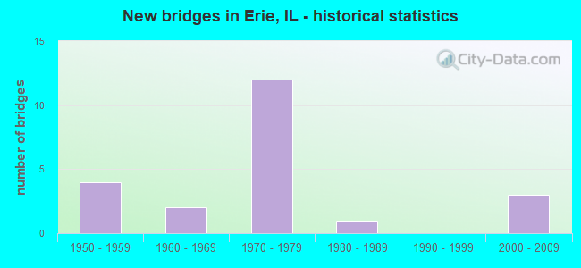
- New bridges - historical statistics
- 41950-1959
- 21960-1969
- 121970-1979
- 11980-1989
- 32000-2009

- Reconstructed bridges - Historical Statistics
- 11990-1999
- 12000-2009


- Bridge Condition - Deck
- 8.3%Very good
- 33.3%Good
- 41.7%Satisfactory
- 16.7%Fair

- Bridge Condition - Superstructure
- 8.3%Very good
- 33.3%Good
- 41.7%Satisfactory
- 16.7%Fair

- Bridge Condition - Substructure
- 25.0%Very good
- 41.7%Good
- 16.7%Satisfactory
- 16.7%Fair

- Bridge Condition - Channel
- 31.3%Very good
- 18.8%Good
- 31.3%Satisfactory
- 18.8%Fair

- Bridge Condition - Culverts
- 16.7%Very good
- 50.0%Good
- 33.3%Satisfactory
Find on map >> Show street view
Structure Number: 980002, Location: 2.5 MI E ERIE (Lat: 41.679858, Lng: -90.025836), Route carried "on" structure: County highway , Year Built: 1971, Year Reconstructed: 2006, Status: Open, Structure Length: 5.27m (17.29ft), Average Daily Traffic: 1,000 (year 2021), Truck Traffic: 8%, Average Future Daily Traffic: 1,100 (year 2040), Design Load: HS 20, Features Intersected: ROCK CREEK, Facility Carried by Structure: MOLINE RD
Minimum Vertical Clearance: 30+ m (98+ ft), Kilometerpoint: 5.826, Lanes on structure: 2, Owner: State Highway Agency, Approaching Roadway Width: 7.9m (25.9ft), Skew: 3 degrees, Material/Design: Prestressed concrete, Design/Construction: Box Beam or Girders - Multiple, Number Of Spans In Main Unit: 3, Length of Maximum Span: 17.6m (57.7ft), Curb-To-Curb Width: 10.0m (32.8ft), Out-to-Out Width: 10.1m (33.1ft)
Condition: Deck: Good, Superstructure: Good, Substructure: Satisfactory, Channel: Satisfactory, Operating Rating: 64.2 metric tons, Method Used To Determine Operating Rating: Load Factor (LF) rating reported by rating factor (RF) method using MS18 loading, Inventory Rating: 40.2 metric tons, Method Used To Determine Inventory Rating: Load Factor (LF) rating reported by rating factor (RF) method using MS18 loading, Structural Evaluation: Equal to present minimum criteria, Deck Geometry: Equal to present minimum criteria, Waterway Adequacy: Equal to present desirable criteria, Approach Roadway Alignment: Equal to present desirable criteria, Designated Inspection Frequency: Every 24 months, Underwater Inspection Frequency: Every 24 months, Inspection Date: July 2021, Underwater Inspection Date: July 2021, Deck Structure Type: Concrete Precast Panels, Wearing Surface/Protective System: Wearing Surface: Integral Concrete
Find on map >> Show street view
Structure Number: 980055, Location: 2.5 MI. W.ERIE (Lat: 41.664731, Lng: -90.142500), Route carried "on" structure: County highway , Year Built: 1975, Status: Open, Structure Length: 14.18m (46.52ft), Average Daily Traffic: 325 (year 2016), Truck Traffic: 8%, Average Future Daily Traffic: 700 (year 2040), Design Load: HS 15, Features Intersected: I-88, Facility Carried by Structure: FAS 2184 CORDOVA R
Minimum Vertical Clearance: 30+ m (98+ ft), Kilometerpoint: 4.088, Lanes on structure: 2, Lanes under structure: 4, Owner: State Highway Agency, Approaching Roadway Width: 11.0m (36.1ft), Material/Design: Steel continuous, Design/Construction: Stringer/Multi-beam, Number Of Spans In Main Unit: 4, Number Of Approach Spans: 2, Length of Maximum Span: 31.9m (104.7ft), Curb-To-Curb Width: 10.5m (34.4ft), Out-to-Out Width: 11.6m (38.1ft)
Condition: Deck: Fair, Superstructure: Satisfactory, Substructure: Fair, Channel: Very good, Operating Rating: 52.2 metric tons, Method Used To Determine Operating Rating: Allowable Stress (AS) rating reported by rating factor (RF) method using MS18 loading, Inventory Rating: 27.9 metric tons, Method Used To Determine Inventory Rating: Allowable Stress (AS) rating reported by rating factor (RF) method using MS18 loading, Structural Evaluation: Somewhat better than minimum adequacy, Deck Geometry: Better than present minimum criteria, Underclear: Somewhat better than minimum adequacy, Waterway Adequacy: Superior to present desirable criteria, Approach Roadway Alignment: Equal to present desirable criteria, Designated Inspection Frequency: Every 24 months, Inspection Date: December 2021, Deck Structure Type: Concrete Cast-file-Place, Wearing Surface/Protective System: Wearing Surface: Bituminous, Membrane: Built-up
Find on map >> Show street view
Structure Number: 980056, Location: 2.5 MI. NW. ERIE (Lat: 41.680339, Lng: -90.131539), Route carried "on" structure: County highway , Year Built: 1975, Status: Open, Structure Length: 16.50m (54.13ft), Average Daily Traffic: 400 (year 2021), Truck Traffic: 11%, Average Future Daily Traffic: 350 (year 2040), Design Load: HS 15, Features Intersected: I-88 & STREAM, Facility Carried by Structure: CH 21 SAND RD
Minimum Vertical Clearance: 30+ m (98+ ft), Kilometerpoint: 13.325, Lanes on structure: 2, Lanes under structure: 4, Owner: State Highway Agency, Approaching Roadway Width: 8.5m (27.9ft), Skew: 4 degrees, Material/Design: Steel continuous, Design/Construction: Stringer/Multi-beam, Number Of Spans In Main Unit: 3, Number Of Approach Spans: 2, Length of Maximum Span: 56.2m (184.4ft), Curb-To-Curb Width: 8.1m (26.6ft), Out-to-Out Width: 9.1m (29.9ft)
Condition: Deck: Good, Superstructure: Good, Substructure: Good, Channel: Satisfactory, Operating Rating: 47.3 metric tons, Method Used To Determine Operating Rating: Load Factor (LF) rating reported by rating factor (RF) method using MS18 loading, Inventory Rating: 28.5 metric tons, Method Used To Determine Inventory Rating: Load Factor (LF) rating reported by rating factor (RF) method using MS18 loading, Structural Evaluation: Better than present minimum criteria, Deck Geometry: Somewhat better than minimum adequacy, Underclear: Somewhat better than minimum adequacy, Waterway Adequacy: Equal to present desirable criteria, Approach Roadway Alignment: Equal to present desirable criteria, Designated Inspection Frequency: Every 24 months, Inspection Date: September 2020, Deck Structure Type: Concrete Cast-file-Place, Wearing Surface/Protective System: Wearing Surface: Bituminous, Membrane: Built-up
Find on map >> Show street view
Structure Number: 980057, Location: 2.0 MI. N. ERIE (Lat: 41.688817, Lng: -90.097225), Route carried "on" structure: County highway , Year Built: 1975, Year Reconstructed: 2003, Status: Open, Structure Length: 8.53m (27.99ft), Average Daily Traffic: 1,300 (year 2021), Truck Traffic: 9%, Average Future Daily Traffic: 1,100 (year 2040), Design Load: HS 20, Features Intersected: I-88, Facility Carried by Structure: FAS 1225 ALBANY RD
Minimum Vertical Clearance: 30+ m (98+ ft), Kilometerpoint: 16.415, Lanes on structure: 2, Lanes under structure: 4, Owner: State Highway Agency, Approaching Roadway Width: 12.8m (42.0ft), Skew: 33 degrees, Material/Design: Steel continuous, Design/Construction: Stringer/Multi-beam, Number Of Spans In Main Unit: 2, Number Of Approach Spans: 2, Length of Maximum Span: 32.0m (105.0ft), Curb-To-Curb Width: 14.2m (46.6ft), Out-to-Out Width: 20.7m (67.9ft)
Condition: Deck: Satisfactory, Superstructure: Satisfactory, Substructure: Satisfactory, Operating Rating: 39.2 metric tons, Method Used To Determine Operating Rating: Load Factor (LF) rating reported by rating factor (RF) method using MS18 loading, Inventory Rating: 23.3 metric tons, Method Used To Determine Inventory Rating: Load Factor (LF) rating reported by rating factor (RF) method using MS18 loading, Structural Evaluation: Equal to present minimum criteria, Deck Geometry: Superior to present desirable criteria, Underclear: Somewhat better than minimum adequacy, Approach Roadway Alignment: Equal to present desirable criteria, Designated Inspection Frequency: Every 24 months, Inspection Date: September 2021, Deck Structure Type: Concrete Cast-file-Place, Wearing Surface/Protective System: Wearing Surface: Bituminous, Membrane: Built-up
Find on map >> Show street view
Structure Number: 980058, Location: 3.0 MI. NE. ERIE (Lat: 41.704581, Lng: -90.054800), Route carried "on" structure: County highway , Year Built: 1975, Status: Open, Structure Length: 8.66m (28.41ft), Average Daily Traffic: 200 (year 2021), Truck Traffic: 14%, Average Future Daily Traffic: 500 (year 2040), Design Load: HS 15, Features Intersected: I-88, Facility Carried by Structure: CH 17 WILMOT RD
Minimum Vertical Clearance: 30+ m (98+ ft), Kilometerpoint: 5.359, Lanes on structure: 2, Lanes under structure: 4, Owner: State Highway Agency, Approaching Roadway Width: 9.1m (29.9ft), Skew: 2 degrees, Material/Design: Steel continuous, Design/Construction: Stringer/Multi-beam, Number Of Spans In Main Unit: 2, Number Of Approach Spans: 2, Length of Maximum Span: 35.7m (117.1ft), Curb-To-Curb Width: 8.7m (28.5ft), Out-to-Out Width: 9.8m (32.2ft)
Condition: Deck: Good, Superstructure: Satisfactory, Substructure: Good, Operating Rating: 56.4 metric tons, Method Used To Determine Operating Rating: Load Factor (LF) rating reported by rating factor (RF) method using MS18 loading, Inventory Rating: 33.7 metric tons, Method Used To Determine Inventory Rating: Load Factor (LF) rating reported by rating factor (RF) method using MS18 loading, Structural Evaluation: Equal to present minimum criteria, Deck Geometry: Equal to present minimum criteria, Underclear: Equal to present minimum criteria, Approach Roadway Alignment: Equal to present desirable criteria, Designated Inspection Frequency: Every 24 months, Inspection Date: August 2020, Deck Structure Type: Concrete Cast-file-Place, Wearing Surface/Protective System: Wearing Surface: Bituminous, Membrane: Built-up
Find on map >> Show street view
Structure Number: 980059, Location: 4.5 MI. NE. ERIE (Lat: 41.708164, Lng: -90.025322), Route carried "on" structure: Interstate 88, Year Built: 1975, Status: Open, Structure Length: 5.38m (17.65ft), Average Daily Traffic: 7,200 (year 2021), Truck Traffic: 28%, Average Future Daily Traffic: 8,100 (year 2040), Design Load: HS 20, Features Intersected: ROCK CREEK
Minimum Vertical Clearance: 30+ m (98+ ft), Kilometerpoint: 36.274, Lanes on structure: 2, Base Highway Network: Yes, Owner: State Highway Agency, Approaching Roadway Width: 12.8m (42.0ft), Skew: 1 degrees, Material/Design: Steel continuous, Design/Construction: Stringer/Multi-beam, Number Of Spans In Main Unit: 3, Length of Maximum Span: 22.9m (75.1ft), Curb-To-Curb Width: 11.7m (38.4ft), Out-to-Out Width: 12.8m (42.0ft)
Condition: Deck: Good, Superstructure: Satisfactory, Substructure: Very good, Channel: Satisfactory, Operating Rating: 64.2 metric tons, Method Used To Determine Operating Rating: Load Factor (LF) rating reported by rating factor (RF) method using MS18 loading, Inventory Rating: 38.6 metric tons, Method Used To Determine Inventory Rating: Load Factor (LF) rating reported by rating factor (RF) method using MS18 loading, Structural Evaluation: Equal to present minimum criteria, Deck Geometry: Equal to present minimum criteria, Waterway Adequacy: Equal to present desirable criteria, Approach Roadway Alignment: Equal to present desirable criteria, Designated Inspection Frequency: Every 24 months, Inspection Date: September 2021, Deck Structure Type: Concrete Cast-file-Place, Wearing Surface/Protective System: Wearing Surface: Other
Find on map >> Show street view
Structure Number: 98201, Location: 2.5 MI W ERIE (Lat: 41.671453, Lng: -90.138350), Route carried "on" structure: Interstate 88, Year Built: 1975, Status: Open, Structure Length: 1.33m (4.36ft), Average Daily Traffic: 14,100 (year 2021), Truck Traffic: 30%, Average Future Daily Traffic: 18,000 (year 2040), Design Load: HS 20+Mod, Features Intersected: DITCH
Minimum Vertical Clearance: 30+ m (98+ ft), Kilometerpoint: 25.363, Lanes on structure: 4, Base Highway Network: Yes, Owner: State Highway Agency, Approaching Roadway Width: 24.4m (80.1ft), Skew: 12 degrees, Material/Design: Concrete, Design/Construction: Culvert, Number Of Spans In Main Unit: 3, Length of Maximum Span: 4.3m (14.1ft)
Condition: Channel: Good, Culverts: Good, Operating Rating: 88.5 metric tons, Method Used To Determine Operating Rating: Load Factor (LF) rating reported by rating factor (RF) method using MS18 loading, Inventory Rating: 52.8 metric tons, Method Used To Determine Inventory Rating: Load Factor (LF) rating reported by rating factor (RF) method using MS18 loading, Structural Evaluation: Better than present minimum criteria, Waterway Adequacy: Equal to present desirable criteria, Approach Roadway Alignment: Equal to present desirable criteria, Designated Inspection Frequency: Every 24 months, Inspection Date: October 2020
Find on map >> Show street view
Structure Number: 982011, Location: 1 MI N OF ERIE (Lat: 41.688947, Lng: -90.087128), Route carried "on" structure: Interstate 88, Year Built: 1975, Status: Open, Structure Length: 0.77m (2.53ft), Average Daily Traffic: 14,400 (year 2021), Truck Traffic: 28%, Average Future Daily Traffic: 16,100 (year 2040), Design Load: HS 20+Mod, Features Intersected: DITCH
Minimum Vertical Clearance: 30+ m (98+ ft), Kilometerpoint: 30.496, Lanes on structure: 4, Base Highway Network: Yes, Owner: State Highway Agency, Approaching Roadway Width: 12.2m (40.0ft), Skew: 13 degrees, Material/Design: Concrete, Design/Construction: Culvert, Number Of Spans In Main Unit: 2, Length of Maximum Span: 3.5m (11.5ft)
Condition: Channel: Good, Culverts: Good, Operating Rating: 97.2 metric tons, Method Used To Determine Operating Rating: Load Factor (LF) rating reported by rating factor (RF) method using MS18 loading, Inventory Rating: 97.2 metric tons, Method Used To Determine Inventory Rating: Load Factor (LF) rating reported by rating factor (RF) method using MS18 loading, Structural Evaluation: Better than present minimum criteria, Waterway Adequacy: Equal to present desirable criteria, Approach Roadway Alignment: Equal to present desirable criteria, Designated Inspection Frequency: Every 24 months, Inspection Date: October 2021
Find on map >> Show street view
Structure Number: 982024, Location: 0.06 MI E WILMOT RD (Lat: 41.670831, Lng: -90.053894), Route carried "on" structure: County highway , Year Built: 2002, Status: Open, Structure Length: 0.89m (2.92ft), Average Daily Traffic: 1,000 (year 2021), Truck Traffic: 8%, Average Future Daily Traffic: 1,100 (year 2040), Design Load: HS 20, Features Intersected: DRAINAGE DITCH, Facility Carried by Structure: MOLINE ROAD
Minimum Vertical Clearance: 30+ m (98+ ft), Kilometerpoint: 8.401, Lanes on structure: 2, Owner: State Highway Agency, Approaching Roadway Width: 9.6m (31.5ft), Material/Design: Concrete, Design/Construction: Culvert, Number Of Spans In Main Unit: 3, Length of Maximum Span: 2.9m (9.5ft)
Condition: Channel: Very good, Culverts: Very good, Operating Rating: 77.4 metric tons, Method Used To Determine Operating Rating: Load Factor (LF) rating reported by rating factor (RF) method using MS18 loading, Inventory Rating: 46.3 metric tons, Method Used To Determine Inventory Rating: Load Factor (LF) rating reported by rating factor (RF) method using MS18 loading, Structural Evaluation: Equal to present desirable criteria, Waterway Adequacy: Equal to present minimum criteria, Approach Roadway Alignment: Equal to present desirable criteria, Designated Inspection Frequency: Every 48 months, Inspection Date: July 2019
Find on map >> Show street view
Structure Number: 983009, Location: 1 MILE SOUTH OF ERIE (Lat: 41.641758, Lng: -90.067256), Route carried "on" structure: County highway , Year Built: 1955, Status: Open, Structure Length: 36.89m (121.03ft), Average Daily Traffic: 1,200 (year 2021), Truck Traffic: 6%, Average Future Daily Traffic: 1,100 (year 2040), Design Load: HS 20, Features Intersected: ROCK RIVER, Facility Carried by Structure: ERIE ROAD
Minimum Vertical Clearance: 30+ m (98+ ft), Kilometerpoint: 22.595, Lanes on structure: 2, Owner: County Highway Agency, Approaching Roadway Width: 11.0m (36.1ft), Material/Design: Steel continuous, Design/Construction: Stringer/Multi-beam, Number Of Spans In Main Unit: 11, Length of Maximum Span: 38.2m (125.3ft), Curb-To-Curb Width: 9.1m (29.9ft), Out-to-Out Width: 9.1m (29.9ft)
Condition: Deck: Satisfactory, Superstructure: Satisfactory, Substructure: Good, Channel: Satisfactory, Operating Rating: 53.8 metric tons, Method Used To Determine Operating Rating: Load Factor (LF) rating reported by rating factor (RF) method using MS18 loading, Inventory Rating: 32.1 metric tons, Method Used To Determine Inventory Rating: Load Factor (LF) rating reported by rating factor (RF) method using MS18 loading, Structural Evaluation: Equal to present minimum criteria, Deck Geometry: Somewhat better than minimum adequacy, Waterway Adequacy: Equal to present desirable criteria, Approach Roadway Alignment: Equal to present desirable criteria, Designated Inspection Frequency: Every 24 months, Underwater Inspection Frequency: Every 60 months, Inspection Date: November 2021, Underwater Inspection Date: July 2019, Deck Structure Type: Concrete Cast-file-Place, Wearing Surface/Protective System: Deck Protection: Epoxy Coated Reinforcing
Find on map >> Show street view
Structure Number: 983032, Location: 2.25 MI NW OF ERIE (Lat: 41.671044, Lng: -90.132050), Route carried "on" structure: County highway , Year Built: 1964, Status: Open, Structure Length: 1.63m (5.35ft), Average Daily Traffic: 400 (year 2021), Truck Traffic: 11%, Average Future Daily Traffic: 350 (year 2040), Design Load: HS 20, Features Intersected: SPRING CREEK, Facility Carried by Structure: SAND ROAD
Minimum Vertical Clearance: 30+ m (98+ ft), Kilometerpoint: 14.484, Lanes on structure: 2, Owner: County Highway Agency, Approaching Roadway Width: 8.5m (27.9ft), Skew: 1 degrees, Material/Design: Steel, Design/Construction: Stringer/Multi-beam, Number Of Spans In Main Unit: 1, Length of Maximum Span: 14.9m (48.9ft), Curb-To-Curb Width: 7.3m (24.0ft), Out-to-Out Width: 8.6m (28.2ft)
Condition: Deck: Satisfactory, Superstructure: Fair, Substructure: Good, Channel: Good, Operating Rating: 47.0 metric tons, Method Used To Determine Operating Rating: Load Factor (LF) rating reported by rating factor (RF) method using MS18 loading, Inventory Rating: 27.9 metric tons, Method Used To Determine Inventory Rating: Load Factor (LF) rating reported by rating factor (RF) method using MS18 loading, Structural Evaluation: Somewhat better than minimum adequacy, Deck Geometry: Somewhat better than minimum adequacy, Waterway Adequacy: Equal to present desirable criteria, Approach Roadway Alignment: Equal to present desirable criteria, Designated Inspection Frequency: Every 24 months, Inspection Date: March 2020, Deck Structure Type: Concrete Cast-file-Place, Wearing Surface/Protective System: Wearing Surface: Bituminous
Find on map >> Show street view
Structure Number: 983038, Location: 3 MI N OF ERIE (Lat: 41.703906, Lng: -90.099569), Route carried "on" structure: County highway , Year Built: 1959, Status: Open, Structure Length: 0.81m (2.66ft), Average Daily Traffic: 250 (year 2021), Truck Traffic: 33%, Average Future Daily Traffic: 400 (year 2040), Design Load: HS 15, Features Intersected: MINERAL SPRINGS CRK., Facility Carried by Structure: BURNS RD
Minimum Vertical Clearance: 30+ m (98+ ft), Kilometerpoint: 0.080, Lanes on structure: 2, Owner: County Highway Agency, Approaching Roadway Width: 9.1m (29.9ft), Material/Design: Concrete, Design/Construction: Culvert, Number Of Spans In Main Unit: 2, Length of Maximum Span: 4.0m (13.1ft)
Condition: Channel: Fair, Culverts: Satisfactory, Operating Rating: 44.7 metric tons, Method Used To Determine Operating Rating: Load Factor (LF) rating reported by rating factor (RF) method using MS18 loading, Inventory Rating: 26.9 metric tons, Method Used To Determine Inventory Rating: Load Factor (LF) rating reported by rating factor (RF) method using MS18 loading, Structural Evaluation: Equal to present minimum criteria, Waterway Adequacy: Better than present minimum criteria, Approach Roadway Alignment: Better than present minimum criteria, Designated Inspection Frequency: Every 24 months, Inspection Date: April 2020
Find on map >> Show street view
Structure Number: 983039, Location: 3 MI N OF ERIE (Lat: 41.709883, Lng: -90.073189), Route carried "on" structure: County highway , Year Built: 1959, Status: Open, Structure Length: 0.82m (2.69ft), Average Daily Traffic: 250 (year 2021), Truck Traffic: 33%, Average Future Daily Traffic: 400 (year 2040), Design Load: HS 15, Features Intersected: DRAINAGE DITCH, Facility Carried by Structure: BURNS RD
Minimum Vertical Clearance: 30+ m (98+ ft), Kilometerpoint: 2.398, Lanes on structure: 2, Owner: County Highway Agency, Approaching Roadway Width: 9.1m (29.9ft), Skew: 2 degrees, Material/Design: Concrete, Design/Construction: Culvert, Number Of Spans In Main Unit: 2, Length of Maximum Span: 3.9m (12.8ft)
Condition: Channel: Fair, Culverts: Good, Operating Rating: 45.0 metric tons, Method Used To Determine Operating Rating: Load Factor (LF) rating reported by rating factor (RF) method using MS18 loading, Inventory Rating: 27.2 metric tons, Method Used To Determine Inventory Rating: Load Factor (LF) rating reported by rating factor (RF) method using MS18 loading, Structural Evaluation: Equal to present minimum criteria, Waterway Adequacy: Better than present minimum criteria, Approach Roadway Alignment: Better than present minimum criteria, Designated Inspection Frequency: Every 24 months, Inspection Date: April 2020
Find on map >> Show street view
Structure Number: 98304, Location: 3 MI N OF ERIE (Lat: 41.711444, Lng: -90.066761), Route carried "on" structure: County highway , Year Built: 1958, Status: Open, Structure Length: 0.82m (2.69ft), Average Daily Traffic: 250 (year 2021), Truck Traffic: 33%, Average Future Daily Traffic: 400 (year 2040), Design Load: HS 15, Features Intersected: DRAINAGE DITCH, Facility Carried by Structure: BURNS RD
Minimum Vertical Clearance: 30+ m (98+ ft), Kilometerpoint: 2.961, Lanes on structure: 2, Owner: County Highway Agency, Approaching Roadway Width: 9.1m (29.9ft), Material/Design: Concrete, Design/Construction: Culvert, Number Of Spans In Main Unit: 2, Length of Maximum Span: 3.9m (12.8ft)
Condition: Channel: Satisfactory, Culverts: Satisfactory, Operating Rating: 42.4 metric tons, Method Used To Determine Operating Rating: Load Factor (LF) rating reported by rating factor (RF) method using MS18 loading, Inventory Rating: 25.6 metric tons, Method Used To Determine Inventory Rating: Load Factor (LF) rating reported by rating factor (RF) method using MS18 loading, Structural Evaluation: Equal to present minimum criteria, Waterway Adequacy: Equal to present minimum criteria, Approach Roadway Alignment: Equal to present desirable criteria, Designated Inspection Frequency: Every 24 months, Inspection Date: April 2020
Find on map >> Show street view
Structure Number: 983069, Location: 2 MI NORTH OF ERIE (Lat: 41.692903, Lng: -90.099883), Route carried "on" structure: County highway , Year Built: 2007, Status: Open, Structure Length: 1.61m (5.28ft), Average Daily Traffic: 1,400 (year 2021), Truck Traffic: 9%, Average Future Daily Traffic: 3,900 (year 2040), Design Load: HS 20, Features Intersected: MINERAL SPRINGS CRK., Facility Carried by Structure: ALBANY ROAD
Minimum Vertical Clearance: 30+ m (98+ ft), Kilometerpoint: 15.964, Lanes on structure: 2, Owner: County Highway Agency, Approaching Roadway Width: 9.1m (29.9ft), Skew: 1 degrees, Material/Design: Steel, Design/Construction: Stringer/Multi-beam, Number Of Spans In Main Unit: 1, Length of Maximum Span: 14.5m (47.6ft), Curb-To-Curb Width: 10.4m (34.1ft), Out-to-Out Width: 10.4m (34.1ft)
Condition: Deck: Satisfactory, Superstructure: Good, Substructure: Good, Channel: Very good, Operating Rating: 53.8 metric tons, Method Used To Determine Operating Rating: Load Factor (LF) rating reported by rating factor (RF) method using MS18 loading, Inventory Rating: 32.4 metric tons, Method Used To Determine Inventory Rating: Load Factor (LF) rating reported by rating factor (RF) method using MS18 loading, Structural Evaluation: Better than present minimum criteria, Deck Geometry: Equal to present minimum criteria, Waterway Adequacy: Equal to present desirable criteria, Approach Roadway Alignment: Equal to present desirable criteria, Designated Inspection Frequency: Every 48 months, Inspection Date: April 2021, Deck Structure Type: Concrete Cast-file-Place
Find on map >> Show street view
Structure Number: 98307, Location: 0.5 MI NORTH OF ERIE (Lat: 41.673397, Lng: -90.084869), Route carried "on" structure: County highway , Year Built: 2007, Status: Open, Structure Length: 1.60m (5.25ft), Average Daily Traffic: 1,200 (year 2021), Truck Traffic: 9%, Average Future Daily Traffic: 2,000 (year 2040), Design Load: HS 20, Features Intersected: DRAINAGE DITCH, Facility Carried by Structure: ALBANY ROAD
Minimum Vertical Clearance: 30+ m (98+ ft), Kilometerpoint: 18.475, Lanes on structure: 2, Owner: County Highway Agency, Approaching Roadway Width: 10.4m (34.1ft), Material/Design: Steel, Design/Construction: Stringer/Multi-beam, Number Of Spans In Main Unit: 1, Length of Maximum Span: 14.5m (47.6ft), Curb-To-Curb Width: 10.4m (34.1ft), Out-to-Out Width: 10.4m (34.1ft)
Condition: Deck: Satisfactory, Superstructure: Very good, Substructure: Very good, Channel: Very good, Operating Rating: 53.8 metric tons, Method Used To Determine Operating Rating: Load Factor (LF) rating reported by rating factor (RF) method using MS18 loading, Inventory Rating: 32.4 metric tons, Method Used To Determine Inventory Rating: Load Factor (LF) rating reported by rating factor (RF) method using MS18 loading, Structural Evaluation: Equal to present desirable criteria, Deck Geometry: Equal to present minimum criteria, Waterway Adequacy: Equal to present desirable criteria, Approach Roadway Alignment: Equal to present desirable criteria, Designated Inspection Frequency: Every 48 months, Inspection Date: March 2018, Deck Structure Type: Concrete Cast-file-Place
Find on map >> Show street view
Structure Number: 983957, Location: 3 MI NE ERIE (Lat: 41.699706, Lng: -90.026519), Route carried "on" structure: County highway , Year Built: 1982, Status: Open, Structure Length: 2.87m (9.42ft), Average Daily Traffic: 25 (year 2022), Average Future Daily Traffic: 25 (year 2040), Design Load: HS 20, Features Intersected: ROCK CREEK, Facility Carried by Structure: HILL RD
Minimum Vertical Clearance: 30+ m (98+ ft), Kilometerpoint: 2.993, Lanes on structure: 2, Owner: Town or Township Highway Agency, Approaching Roadway Width: 4.6m (15.1ft), Material/Design: Prestressed concrete, Design/Construction: Box Beam or Girders - Multiple, Number Of Spans In Main Unit: 3, Length of Maximum Span: 13.4m (44.0ft), Curb-To-Curb Width: 8.8m (28.9ft), Out-to-Out Width: 8.8m (28.9ft)
Condition: Deck: Fair, Superstructure: Fair, Substructure: Fair, Channel: Fair, Operating Rating: 44.4 metric tons, Method Used To Determine Operating Rating: Assigned rating based on Load Factor Design (LFD) reported by rating factor (RF) using MS18 loading, Inventory Rating: 32.4 metric tons, Method Used To Determine Inventory Rating: Assigned rating based on Load Factor Design (LFD) reported by rating factor (RF) using MS18 loading, Structural Evaluation: Somewhat better than minimum adequacy, Deck Geometry: Better than present minimum criteria, Waterway Adequacy: Equal to present desirable criteria, Approach Roadway Alignment: Equal to present desirable criteria, Designated Inspection Frequency: Every 24 months, Inspection Date: November 2020, Deck Structure Type: Concrete Precast Panels
Find on map >> Show street view
Structure Number: 985205, Location: 2.5 MI NW ERIE (Lat: 41.685872, Lng: -90.124975), Route carried "on" structure: County highway , Year Built: 1969, Status: Open, Structure Length: 2.03m (6.66ft), Average Daily Traffic: 10 (year 2022), Average Future Daily Traffic: 10 (year 2040), Design Load: HS 15, Features Intersected: MEREDOSIA DITCH, Facility Carried by Structure: STAR RD
Minimum Vertical Clearance: 30+ m (98+ ft), Kilometerpoint: 8.545, Lanes on structure: 2, Owner: Town or Township Highway Agency, Approaching Roadway Width: 4.9m (16.1ft), Skew: 4 degrees, Material/Design: Steel, Design/Construction: Stringer/Multi-beam, Number Of Spans In Main Unit: 1, Length of Maximum Span: 18.4m (60.4ft), Curb-To-Curb Width: 7.3m (24.0ft), Out-to-Out Width: 8.2m (26.9ft)
Condition: Deck: Very good, Superstructure: Good, Substructure: Very good, Channel: Very good, Operating Rating: 63.5 metric tons, Method Used To Determine Operating Rating: Load Factor (LF) rating reported by rating factor (RF) method using MS18 loading, Inventory Rating: 38.2 metric tons, Method Used To Determine Inventory Rating: Load Factor (LF) rating reported by rating factor (RF) method using MS18 loading, Structural Evaluation: Better than present minimum criteria, Deck Geometry: Equal to present minimum criteria, Waterway Adequacy: Better than present minimum criteria, Approach Roadway Alignment: Equal to present minimum criteria, Designated Inspection Frequency: Every 24 months, Inspection Date: August 2020, Deck Structure Type: Concrete Cast-file-Place
Find on map >> Show street view
Structure Number: 980055, Location: 2.5 MI. W.ERIE (Lat: 41.664731, Lng: -90.142500), Route carried "under" structure: Interstate 88, Year Built: 1975, Structure Length: 0. m, Average Daily Traffic: 14,100 (year 2021), Truck Traffic: 30%, Features Intersected: I-88, Facility Carried by Structure: FAS 2184 CORDOVA R
Minimum Vertical Clearance: 5.03m (16.50ft), Kilometerpoint: 24.542, Lanes on structure: 2, Lanes under structure: 4, Material/Design: Steel continuous, Design/Construction: Stringer/Multi-beam, Length of Maximum Span: 31.9m (104.7ft)
Find on map >> Show street view
Structure Number: 980056, Location: 2.5 MI. NW. ERIE (Lat: 41.680644, Lng: -90.131122), Route carried "under" structure: Interstate 88, Year Built: 1975, Structure Length: 0. m, Average Daily Traffic: 14,100 (year 2021), Truck Traffic: 30%, Features Intersected: I-88 & STREAM, Facility Carried by Structure: CH 21 SAND RD
Minimum Vertical Clearance: 5.26m (17.26ft), Kilometerpoint: 26.553, Lanes on structure: 2, Lanes under structure: 4, Material/Design: Steel continuous, Design/Construction: Stringer/Multi-beam, Length of Maximum Span: 56.2m (184.4ft)
Find on map >> Show street view
Structure Number: 980057, Location: 2.0 MI. N. ERIE (Lat: 41.688817, Lng: -90.097225), Route carried "under" structure: Interstate 88, Year Built: 1975, Structure Length: 0. m, Average Daily Traffic: 14,400 (year 2021), Truck Traffic: 28%, Features Intersected: I-88, Facility Carried by Structure: FAS 1225 ALBANY RD
Minimum Vertical Clearance: 4.90m (16.08ft), Kilometerpoint: 29.675, Lanes on structure: 2, Lanes under structure: 4, Material/Design: Steel continuous, Design/Construction: Stringer/Multi-beam, Length of Maximum Span: 32.0m (105.0ft)
Find on map >> Show street view
Structure Number: 980058, Location: 3.0 MI. NE. ERIE (Lat: 41.704761, Lng: -90.054272), Route carried "under" structure: Interstate 88, Year Built: 1975, Structure Length: 0. m, Average Daily Traffic: 14,400 (year 2021), Truck Traffic: 28%, Features Intersected: I-88, Facility Carried by Structure: CH 17 WILMOT RD
Minimum Vertical Clearance: 4.90m (16.08ft), Kilometerpoint: 33.811, Lanes on structure: 2, Lanes under structure: 4, Material/Design: Steel continuous, Design/Construction: Stringer/Multi-beam, Length of Maximum Span: 35.7m (117.1ft)