Bridge Statistics for Epes, Alabama (AL)
Condition, Traffic, Stress, Structural Evaluation, Project Costs
- National Bridge Inventory (NBI) Statistics
- 36Number of bridges
- 1,424ft / 434mTotal length
- $130,033,000Total costs
- 269,239Total average daily traffic
- 105,301Total average daily truck traffic
- National Bridge Inventory (NBI) Registered Bridges for Epes
- No street view available for this location
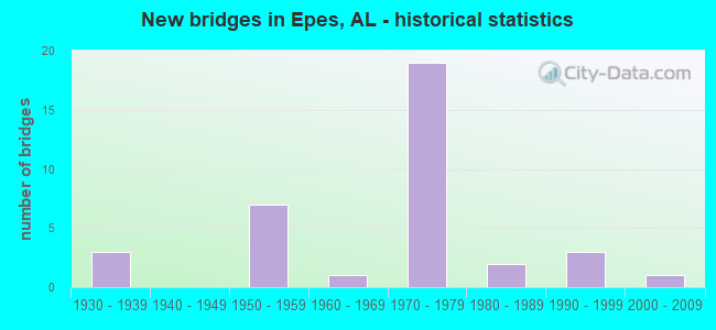
- New bridges - historical statistics
- 31930-1939
- 71950-1959
- 11960-1969
- 191970-1979
- 21980-1989
- 31990-1999
- 12000-2009


- Bridge Condition - Deck
- 46.2%Good
- 50.0%Satisfactory
- 3.8%Fair

- Bridge Condition - Superstructure
- 15.4%Very good
- 69.2%Good
- 15.4%Satisfactory

- Bridge Condition - Substructure
- 11.5%Very good
- 69.2%Good
- 19.2%Satisfactory

- Bridge Condition - Channel
- 22.2%Very good
- 37.0%Good
- 40.7%Satisfactory

- Bridge Condition - Culverts
- 16.7%Good
- 83.3%Satisfactory
Find on map >> Show street view
Structure Number: 737, Location: 0.4 MI. S. OF EPES (Lat: 32.686789, Lng: -88.134717), Route carried "on" structure: US 11, Year Built: 1930, Status: Open, Structure Length: 0.61m (2.00ft), Average Daily Traffic: 1,340 (year 2013), Truck Traffic: 17%, Average Future Daily Traffic: 1,791 (year 2041), Design Load: H 15, Features Intersected: WIGGINS CREEK
Minimum Vertical Clearance: 30+ m (98+ ft), Kilometerpoint: 41.244, Lanes on structure: 2, Owner: State Highway Agency, Approaching Roadway Width: 12.2m (40.0ft), Material/Design: Concrete, Design/Construction: Culvert, Number Of Spans In Main Unit: 2, Length of Maximum Span: 3.0m (9.8ft)
Condition: Channel: Satisfactory, Culverts: Satisfactory, Operating Rating: 57.4 metric tons, Method Used To Determine Operating Rating: Load Factor (LF), Inventory Rating: 34.4 metric tons, Method Used To Determine Inventory Rating: Load Factor (LF), Structural Evaluation: Equal to present minimum criteria, Waterway Adequacy: Equal to present minimum criteria, Approach Roadway Alignment: Equal to present desirable criteria, Length Of Structure Improvement: 1.22m (4.00ft), Designated Inspection Frequency: Every 24 months, Inspection Date: March 2021, Bridge Improvement Cost: $225,000, Roadway Improvement Cost: $23,000, Total Project Cost: $248,000 ( Estimate for 2022)
Find on map >> Show street view
Structure Number: 4091, Location: 1.4 W AL HWY 39 (Lat: 32.705000, Lng: -88.190000), Route carried "on" structure: County highway 1087, Year Built: 1951, Status: Open, Structure Length: 0.91m (2.99ft), Average Daily Traffic: 256 (year 2016), Truck Traffic: 9%, Average Future Daily Traffic: 724 (year 2036), Design Load: H 15, Features Intersected: CO RT 1087 STREAM, Facility Carried by Structure: ROADWAY
Minimum Vertical Clearance: 30+ m (98+ ft), Kilometerpoint: 0.000, Lanes on structure: 2, Owner: County Highway Agency, Approaching Roadway Width: 7.3m (24.0ft), Material/Design: Concrete, Design/Construction: Culvert, Number Of Spans In Main Unit: 2, Length of Maximum Span: 3.0m (9.8ft)
Condition: Channel: Satisfactory, Culverts: Satisfactory, Operating Rating: 46.3 metric tons, Method Used To Determine Operating Rating: Load Factor (LF), Inventory Rating: 27.8 metric tons, Method Used To Determine Inventory Rating: Load Factor (LF), Structural Evaluation: Equal to present minimum criteria, Waterway Adequacy: Equal to present desirable criteria, Approach Roadway Alignment: Better than present minimum criteria, Length Of Structure Improvement: 1.59m (5.22ft), Designated Inspection Frequency: Every 24 months, Inspection Date: July 2020, Bridge Improvement Cost: $275,000, Roadway Improvement Cost: $28,000, Total Project Cost: $303,000 ( Estimate for 2022), Wearing Surface/Protective System: Wearing Surface: Bituminous
Find on map >> Show street view
Structure Number: 4092, Location: 5.5 MI E SUMTERVILLE (Lat: 32.702261, Lng: -88.147497), Route carried "on" structure: County highway 1087, Year Built: 1951, Status: Posted for load, Structure Length: 3.29m (10.79ft), Average Daily Traffic: 210 (year 2022), Truck Traffic: 6%, Average Future Daily Traffic: 300 (year 2039), Design Load: H 15, Features Intersected: CO RT 1087 JONES CREEK, Facility Carried by Structure: ROADWAY
Minimum Vertical Clearance: 30+ m (98+ ft), Kilometerpoint: 0.000, Lanes on structure: 2, Owner: County Highway Agency, Approaching Roadway Width: 7.3m (24.0ft), Material/Design: Steel, Design/Construction: Stringer/Multi-beam, Number Of Spans In Main Unit: 3, Length of Maximum Span: 11.0m (36.1ft), Curb-To-Curb Width: 6.6m (21.7ft), Out-to-Out Width: 7.7m (25.3ft)
Condition: Deck: Good, Superstructure: Good, Substructure: Satisfactory, Channel: Satisfactory, Operating Rating: 30.3 metric tons, Method Used To Determine Operating Rating: Load Factor (LF), Inventory Rating: 18.1 metric tons, Method Used To Determine Inventory Rating: Load Factor (LF), Structural Evaluation: Somewhat better than minimum adequacy, Deck Geometry: Meets minimum limits, Waterway Adequacy: Equal to present desirable criteria, Approach Roadway Alignment: Equal to present desirable criteria, Bridge Posting: Required (Relationship of Operating Rating to Maximum Legal Load: > 39.9% below), Length Of Structure Improvement: 4.17m (13.68ft), Designated Inspection Frequency: Every 24 months, Other Special Inspection Frequency: Every 12 months, Inspection Date: Febuary 2022, Other Special Inspection Date: Febuary 2022, Bridge Improvement Cost: $714,000, Roadway Improvement Cost: $71,000, Total Project Cost: $785,000 ( Estimate for 2022), Deck Structure Type: Concrete Cast-file-Place
Find on map >> Show street view
Structure Number: 5139, Location: 1.1 MI. S. OF EPES (Lat: 32.681517, Lng: -88.143558), Route carried "on" structure: US 11, Year Built: 1955, Status: Open, Structure Length: 0.61m (2.00ft), Average Daily Traffic: 1,340 (year 2013), Truck Traffic: 17%, Average Future Daily Traffic: 1,791 (year 2041), Design Load: H 20, Features Intersected: JONES CREEK
Minimum Vertical Clearance: 30+ m (98+ ft), Kilometerpoint: 40.218, Lanes on structure: 2, Owner: State Highway Agency, Approaching Roadway Width: 12.2m (40.0ft), Material/Design: Concrete, Design/Construction: Culvert, Number Of Spans In Main Unit: 2, Length of Maximum Span: 3.0m (9.8ft)
Condition: Channel: Satisfactory, Culverts: Satisfactory, Operating Rating: 87.2 metric tons, Method Used To Determine Operating Rating: Load Factor (LF), Inventory Rating: 52.3 metric tons, Method Used To Determine Inventory Rating: Load Factor (LF), Structural Evaluation: Equal to present minimum criteria, Waterway Adequacy: Equal to present minimum criteria, Approach Roadway Alignment: Equal to present desirable criteria, Length Of Structure Improvement: 1.22m (4.00ft), Designated Inspection Frequency: Every 24 months, Inspection Date: March 2021, Bridge Improvement Cost: $549,000, Roadway Improvement Cost: $55,000, Total Project Cost: $604,000 ( Estimate for 2022)
Find on map >> Show street view
Structure Number: 5334, Location: 1.9 MI N EPES (Lat: 32.720081, Lng: -88.126881), Route carried "on" structure: County highway 1223, Year Built: 1955, Status: Open, Structure Length: 4.79m (15.72ft), Average Daily Traffic: 340 (year 2022), Truck Traffic: 10%, Average Future Daily Traffic: 480 (year 2039), Design Load: H 15, Features Intersected: CO RT 1223 JONES CREEK, Facility Carried by Structure: ROADWAY
Minimum Vertical Clearance: 30+ m (98+ ft), Kilometerpoint: 0.010, Lanes on structure: 2, Owner: County Highway Agency, Approaching Roadway Width: 7.3m (24.0ft), Material/Design: Steel, Design/Construction: Stringer/Multi-beam, Number Of Spans In Main Unit: 1, Number Of Approach Spans: 3, Length of Maximum Span: 16.8m (55.1ft), Curb-To-Curb Width: 6.6m (21.7ft), Out-to-Out Width: 7.7m (25.3ft)
Condition: Deck: Good, Superstructure: Good, Substructure: Good, Channel: Good, Operating Rating: 40.8 metric tons, Method Used To Determine Operating Rating: Load Factor (LF), Inventory Rating: 24.5 metric tons, Method Used To Determine Inventory Rating: Load Factor (LF), Structural Evaluation: Equal to present minimum criteria, Deck Geometry: Meets minimum limits, Waterway Adequacy: Equal to present desirable criteria, Approach Roadway Alignment: Better than present minimum criteria, Length Of Structure Improvement: 5.80m (19.03ft), Designated Inspection Frequency: Every 24 months, Inspection Date: Febuary 2022, Bridge Improvement Cost: $994,000, Roadway Improvement Cost: $99,000, Total Project Cost: $1,093,000 ( Estimate for 2022), Deck Structure Type: Concrete Cast-file-Place
Find on map >> Show street view
Structure Number: 5335, Location: 3.4 MI N EPES (Lat: 32.736467, Lng: -88.132489), Route carried "on" structure: County highway 1186, Year Built: 1955, Status: Open, Structure Length: 3.11m (10.20ft), Average Daily Traffic: 340 (year 2022), Truck Traffic: 10%, Average Future Daily Traffic: 480 (year 2038), Design Load: H 15, Features Intersected: CO RT 1186 CREEK, Facility Carried by Structure: ROADWAY
Minimum Vertical Clearance: 30+ m (98+ ft), Kilometerpoint: 0.010, Lanes on structure: 2, Owner: County Highway Agency, Approaching Roadway Width: 7.3m (24.0ft), Material/Design: Concrete, Design/Construction: Tee Beam, Number Of Spans In Main Unit: 3, Length of Maximum Span: 10.4m (34.1ft), Curb-To-Curb Width: 6.6m (21.7ft), Out-to-Out Width: 7.7m (25.3ft)
Condition: Deck: Good, Superstructure: Good, Substructure: Good, Channel: Good, Operating Rating: 40.8 metric tons, Method Used To Determine Operating Rating: Load Factor (LF), Inventory Rating: 24.5 metric tons, Method Used To Determine Inventory Rating: Load Factor (LF), Structural Evaluation: Equal to present minimum criteria, Deck Geometry: Meets minimum limits, Waterway Adequacy: Equal to present desirable criteria, Approach Roadway Alignment: Better than present minimum criteria, Length Of Structure Improvement: 3.96m (12.99ft), Designated Inspection Frequency: Every 24 months, Inspection Date: January 2022, Bridge Improvement Cost: $679,000, Roadway Improvement Cost: $68,000, Total Project Cost: $747,000 ( Estimate for 2022), Deck Structure Type: Concrete Cast-file-Place
Find on map >> Show street view
Structure Number: 5336, Location: 3.5 MI N EPES (Lat: 32.737733, Lng: -88.132508), Route carried "on" structure: County highway 1186, Year Built: 1955, Status: Posted for load, Structure Length: 6.07m (19.91ft), Average Daily Traffic: 504 (year 2020), Truck Traffic: 20%, Average Future Daily Traffic: 749 (year 2038), Design Load: H 15, Features Intersected: CO RT 1186 FACTORY CREEK, Facility Carried by Structure: ROADWAY
Minimum Vertical Clearance: 30+ m (98+ ft), Kilometerpoint: 0.000, Lanes on structure: 2, Owner: County Highway Agency, Approaching Roadway Width: 7.3m (24.0ft), Material/Design: Steel continuous, Design/Construction: Stringer/Multi-beam, Number Of Spans In Main Unit: 3, Number Of Approach Spans: 2, Length of Maximum Span: 15.2m (49.9ft), Curb-To-Curb Width: 6.6m (21.7ft), Out-to-Out Width: 7.7m (25.3ft)
Condition: Deck: Good, Superstructure: Good, Substructure: Good, Channel: Good, Operating Rating: 39.0 metric tons, Method Used To Determine Operating Rating: Load Factor (LF), Inventory Rating: 23.6 metric tons, Method Used To Determine Inventory Rating: Load Factor (LF), Structural Evaluation: Equal to present minimum criteria, Deck Geometry: High priority of corrective action, Waterway Adequacy: Equal to present desirable criteria, Approach Roadway Alignment: Better than present minimum criteria, Bridge Posting: Required (Relationship of Operating Rating to Maximum Legal Load: 0.1 - 9.9% below), Length Of Structure Improvement: 7.11m (23.33ft), Designated Inspection Frequency: Every 24 months, Other Special Inspection Frequency: Every 12 months, Inspection Date: April 2020, Other Special Inspection Date: April 2021, Bridge Improvement Cost: $1,218,000, Roadway Improvement Cost: $122,000, Total Project Cost: $1,340,000 ( Estimate for 2022), Deck Structure Type: Concrete Cast-file-Place
Find on map >> Show street view
Structure Number: 639, Location: 4.9 MI NE SUMTERVILLE (Lat: 32.738836, Lng: -88.169786), Route carried "on" structure: County highway 1141, Year Built: 1958, Status: Posted for load, Structure Length: 1.46m (4.79ft), Average Daily Traffic: 100 (year 2021), Average Future Daily Traffic: 145 (year 2039), Design Load: H 15, Features Intersected: CO RT 1141 BRANCH, Facility Carried by Structure: ROADWAY
Minimum Vertical Clearance: 30+ m (98+ ft), Kilometerpoint: 0.010, Lanes on structure: 2, Owner: County Highway Agency, Approaching Roadway Width: 7.9m (25.9ft), Material/Design: Concrete, Design/Construction: Channel Beam, Number Of Spans In Main Unit: 3, Length of Maximum Span: 4.9m (16.1ft), Curb-To-Curb Width: 7.0m (23.0ft), Out-to-Out Width: 7.6m (24.9ft)
Condition: Deck: Good, Superstructure: Good, Substructure: Satisfactory, Channel: Good, Operating Rating: 36.3 metric tons, Method Used To Determine Operating Rating: Allowable Stress (AS), Inventory Rating: 23.1 metric tons, Method Used To Determine Inventory Rating: Allowable Stress (AS), Structural Evaluation: Equal to present minimum criteria, Deck Geometry: Somewhat better than minimum adequacy, Waterway Adequacy: Better than present minimum criteria, Approach Roadway Alignment: Better than present minimum criteria, Bridge Posting: Required (Relationship of Operating Rating to Maximum Legal Load: 10.0 - 19.9% below), Length Of Structure Improvement: 2.14m (7.02ft), Designated Inspection Frequency: Every 24 months, Other Special Inspection Frequency: Every 12 months, Inspection Date: August 2020, Other Special Inspection Date: August 2021, Bridge Improvement Cost: $352,000, Roadway Improvement Cost: $35,000, Total Project Cost: $387,000 ( Estimate for 2022), Deck Structure Type: Concrete Precast Panels
Find on map >> Show street view
Structure Number: 7475, Location: .2MI E OF AL 75 (Lat: 34.539647, Lng: -85.811517), Route carried "on" structure: County highway 108, Year Built: 1961, Status: Open, Structure Length: 0.89m (2.92ft), Average Daily Traffic: 866 (year 2021), Truck Traffic: 5%, Average Future Daily Traffic: 1,287 (year 2041), Design Load: H 15, Features Intersected: CANEY CREEK
Minimum Vertical Clearance: 30+ m (98+ ft), Kilometerpoint: 0.010, Lanes on structure: 2, Owner: County Highway Agency, Approaching Roadway Width: 7.3m (24.0ft), Skew: 4 degrees, Material/Design: Concrete, Design/Construction: Culvert, Number Of Spans In Main Unit: 2, Length of Maximum Span: 4.3m (14.1ft)
Condition: Channel: Satisfactory, Culverts: Satisfactory, Operating Rating: 57.6 metric tons, Method Used To Determine Operating Rating: Load Factor (LF), Inventory Rating: 34.6 metric tons, Method Used To Determine Inventory Rating: Load Factor (LF), Structural Evaluation: Equal to present minimum criteria, Waterway Adequacy: Better than present minimum criteria, Approach Roadway Alignment: Equal to present desirable criteria, Length Of Structure Improvement: 1.56m (5.12ft), Designated Inspection Frequency: Every 24 months, Inspection Date: April 2021, Bridge Improvement Cost: $485,000, Roadway Improvement Cost: $49,000, Total Project Cost: $534,000 ( Estimate for 2022), Deck Structure Type: Concrete Cast-file-Place
Find on map >> Show street view
Structure Number: 9839, Location: 2.5 MI N SUMTER CO LINE (Lat: 32.711750, Lng: -88.079550), Route carried "on" structure: US 11, Year Built: 1939, Year Reconstructed: 1969, Status: Open, Structure Length: 23.09m (75.75ft), Average Daily Traffic: 700 (year 2013), Truck Traffic: 13%, Average Future Daily Traffic: 917 (year 2033), Design Load: H 10, Features Intersected: TOMBIGBEE RIVER RELIEF
Minimum Vertical Clearance: 30+ m (98+ ft), Kilometerpoint: 47.349, Lanes on structure: 2, Owner: State Highway Agency, Approaching Roadway Width: 9.1m (29.9ft), Material/Design: Steel continuous, Design/Construction: Stringer/Multi-beam, Number Of Spans In Main Unit: 42, Length of Maximum Span: 5.5m (18.0ft), Curb or Sidewalk Widths: Left: 0.2m (0.7ft), Right: 0.2m (0.7ft), Curb-To-Curb Width: 8.5m (27.9ft), Out-to-Out Width: 9.0m (29.5ft)
Condition: Deck: Satisfactory, Superstructure: Good, Substructure: Satisfactory, Channel: Very good, Operating Rating: 59.7 metric tons, Method Used To Determine Operating Rating: Load Factor (LF), Inventory Rating: 35.7 metric tons, Method Used To Determine Inventory Rating: Load Factor (LF), Structural Evaluation: Equal to present minimum criteria, Deck Geometry: Somewhat better than minimum adequacy, Waterway Adequacy: Equal to present minimum criteria, Approach Roadway Alignment: Equal to present desirable criteria, Length Of Structure Improvement: 23.09m (75.75ft), Designated Inspection Frequency: Every 24 months, Inspection Date: July 2020, Bridge Improvement Cost: $4,591,000, Roadway Improvement Cost: $459,000, Total Project Cost: $5,050,000 ( Estimate for 2022), Deck Structure Type: Concrete Cast-file-Place, Wearing Surface/Protective System: Wearing Surface: Bituminous
Find on map >> Show street view
Structure Number: 10467, Location: 5.2 MI S OF BOLIGEE (Lat: 32.740472, Lng: -88.095358), Route carried "on" structure: Interstate 59, Year Built: 1971, Status: Open, Structure Length: 11.09m (36.38ft), Average Daily Traffic: 18,594 (year 2020), Truck Traffic: 44%, Average Future Daily Traffic: 13,652 (year 2041), Design Load: HS 20, Features Intersected: Tombigbee River Relief
Minimum Vertical Clearance: 30+ m (98+ ft), Kilometerpoint: 44.122, Lanes on structure: 2, Base Highway Network: Yes, Owner: State Highway Agency, Approaching Roadway Width: 11.9m (39.0ft), Skew: 10 degrees, Material/Design: Steel continuous, Design/Construction: Stringer/Multi-beam, Number Of Spans In Main Unit: 4, Length of Maximum Span: 30.5m (100.1ft), Curb or Sidewalk Widths: Left: 0.2m (0.7ft), Right: 0.2m (0.7ft), Curb-To-Curb Width: 12.0m (39.4ft), Out-to-Out Width: 13.1m (43.0ft)
Condition: Deck: Satisfactory, Superstructure: Satisfactory, Substructure: Good, Channel: Very good, Operating Rating: 65.4 metric tons, Method Used To Determine Operating Rating: Load Factor (LF), Inventory Rating: 39.2 metric tons, Method Used To Determine Inventory Rating: Load Factor (LF), Structural Evaluation: Equal to present minimum criteria, Deck Geometry: Equal to present minimum criteria, Waterway Adequacy: Equal to present minimum criteria, Approach Roadway Alignment: Equal to present desirable criteria, Length Of Structure Improvement: 11.98m (39.30ft), Designated Inspection Frequency: Every 24 months, Inspection Date: April 2021, Bridge Improvement Cost: $3,533,000, Roadway Improvement Cost: $353,000, Total Project Cost: $3,886,000 ( Estimate for 2022), Deck Structure Type: Concrete Cast-file-Place
Find on map >> Show street view
Structure Number: 10468, Location: 5.2 MI S OF BOLIGEE (Lat: 32.740300, Lng: -88.096500), Route carried "on" structure: Interstate 59, Year Built: 1971, Status: Open, Structure Length: 11.09m (36.38ft), Average Daily Traffic: 18,594 (year 2020), Truck Traffic: 44%, Average Future Daily Traffic: 13,652 (year 2041), Design Load: HS 20, Features Intersected: Tombigbee River Relief
Minimum Vertical Clearance: 30+ m (98+ ft), Kilometerpoint: 44.122, Lanes on structure: 2, Base Highway Network: Yes, Owner: State Highway Agency, Approaching Roadway Width: 11.9m (39.0ft), Skew: 10 degrees, Material/Design: Steel continuous, Design/Construction: Stringer/Multi-beam, Number Of Spans In Main Unit: 4, Length of Maximum Span: 30.5m (100.1ft), Curb or Sidewalk Widths: Left: 0.2m (0.7ft), Right: 0.2m (0.7ft), Curb-To-Curb Width: 12.0m (39.4ft), Out-to-Out Width: 13.1m (43.0ft)
Condition: Deck: Satisfactory, Superstructure: Good, Substructure: Good, Channel: Very good, Operating Rating: 65.4 metric tons, Method Used To Determine Operating Rating: Load Factor (LF), Inventory Rating: 39.2 metric tons, Method Used To Determine Inventory Rating: Load Factor (LF), Structural Evaluation: Better than present minimum criteria, Deck Geometry: Equal to present minimum criteria, Waterway Adequacy: Equal to present minimum criteria, Approach Roadway Alignment: Equal to present desirable criteria, Length Of Structure Improvement: 11.98m (39.30ft), Designated Inspection Frequency: Every 24 months, Inspection Date: April 2021, Bridge Improvement Cost: $3,533,000, Roadway Improvement Cost: $353,000, Total Project Cost: $3,886,000 ( Estimate for 2022), Deck Structure Type: Concrete Cast-file-Place
Find on map >> Show street view
Structure Number: 10469, Location: 4.8 MI S OF BOLIGEE (Lat: 32.744217, Lng: -88.090800), Route carried "on" structure: Interstate 59, Year Built: 1971, Status: Open, Structure Length: 8.75m (28.71ft), Average Daily Traffic: 18,594 (year 2020), Truck Traffic: 44%, Average Future Daily Traffic: 13,652 (year 2041), Design Load: HS 20, Features Intersected: Tombigbee River Relief
Minimum Vertical Clearance: 30+ m (98+ ft), Kilometerpoint: 44.708, Lanes on structure: 2, Base Highway Network: Yes, Owner: State Highway Agency, Approaching Roadway Width: 11.9m (39.0ft), Skew: 10 degrees, Material/Design: Prestressed concrete continuous, Design/Construction: Stringer/Multi-beam, Number Of Spans In Main Unit: 7, Length of Maximum Span: 12.5m (41.0ft), Curb or Sidewalk Widths: Left: 0.2m (0.7ft), Right: 0.2m (0.7ft), Curb-To-Curb Width: 12.0m (39.4ft), Out-to-Out Width: 13.1m (43.0ft)
Condition: Deck: Satisfactory, Superstructure: Good, Substructure: Good, Channel: Good, Operating Rating: 57.2 metric tons, Method Used To Determine Operating Rating: Load Factor (LF), Inventory Rating: 34.2 metric tons, Method Used To Determine Inventory Rating: Load Factor (LF), Structural Evaluation: Better than present minimum criteria, Deck Geometry: Equal to present minimum criteria, Waterway Adequacy: Equal to present minimum criteria, Approach Roadway Alignment: Equal to present desirable criteria, Length Of Structure Improvement: 9.73m (31.92ft), Designated Inspection Frequency: Every 24 months, Inspection Date: April 2021, Bridge Improvement Cost: $2,868,000, Roadway Improvement Cost: $287,000, Total Project Cost: $3,155,000 ( Estimate for 2022), Deck Structure Type: Concrete Cast-file-Place
Find on map >> Show street view
Structure Number: 1047, Location: 4.8 MI S OF BOLIGEE (Lat: 32.743983, Lng: -88.090533), Route carried "on" structure: Interstate 59, Year Built: 1971, Status: Open, Structure Length: 8.75m (28.71ft), Average Daily Traffic: 18,594 (year 2020), Truck Traffic: 44%, Average Future Daily Traffic: 13,652 (year 2041), Design Load: HS 20, Features Intersected: Tombigbee River Relief
Minimum Vertical Clearance: 30+ m (98+ ft), Kilometerpoint: 44.708, Lanes on structure: 2, Base Highway Network: Yes, Owner: State Highway Agency, Approaching Roadway Width: 11.9m (39.0ft), Skew: 10 degrees, Material/Design: Prestressed concrete continuous, Design/Construction: Stringer/Multi-beam, Number Of Spans In Main Unit: 7, Length of Maximum Span: 12.5m (41.0ft), Curb or Sidewalk Widths: Left: 0.2m (0.7ft), Right: 0.2m (0.7ft), Curb-To-Curb Width: 12.0m (39.4ft), Out-to-Out Width: 13.1m (43.0ft)
Condition: Deck: Good, Superstructure: Good, Substructure: Good, Channel: Very good, Operating Rating: 57.2 metric tons, Method Used To Determine Operating Rating: Load Factor (LF), Inventory Rating: 34.2 metric tons, Method Used To Determine Inventory Rating: Load Factor (LF), Structural Evaluation: Better than present minimum criteria, Deck Geometry: Equal to present minimum criteria, Waterway Adequacy: Equal to present minimum criteria, Approach Roadway Alignment: Equal to present desirable criteria, Length Of Structure Improvement: 9.73m (31.92ft), Designated Inspection Frequency: Every 24 months, Inspection Date: April 2021, Bridge Improvement Cost: $2,868,000, Roadway Improvement Cost: $287,000, Total Project Cost: $3,155,000 ( Estimate for 2022), Deck Structure Type: Concrete Cast-file-Place
Find on map >> Show street view
Structure Number: 10832, Location: 1.5 MI N SUMTER CO LINE (Lat: 32.700600, Lng: -88.091200), Route carried "on" structure: US 11, Year Built: 1930, Year Reconstructed: 1973, Status: Open, Structure Length: 33.83m (110.99ft), Average Daily Traffic: 700 (year 2013), Truck Traffic: 13%, Average Future Daily Traffic: 917 (year 2033), Design Load: H 10, Features Intersected: TOMBIGBEE RIVER RELIEF
Minimum Vertical Clearance: 30+ m (98+ ft), Kilometerpoint: 45.691, Lanes on structure: 2, Owner: State Highway Agency, Approaching Roadway Width: 9.1m (29.9ft), Material/Design: Steel continuous, Design/Construction: Stringer/Multi-beam, Number Of Spans In Main Unit: 65, Length of Maximum Span: 5.5m (18.0ft), Curb or Sidewalk Widths: Left: 0.2m (0.7ft), Right: 0.2m (0.7ft), Curb-To-Curb Width: 8.5m (27.9ft), Out-to-Out Width: 9.0m (29.5ft)
Condition: Deck: Fair, Superstructure: Satisfactory, Substructure: Satisfactory, Channel: Very good, Operating Rating: 59.6 metric tons, Method Used To Determine Operating Rating: Load Factor (LF), Inventory Rating: 35.7 metric tons, Method Used To Determine Inventory Rating: Load Factor (LF), Structural Evaluation: Equal to present minimum criteria, Deck Geometry: Somewhat better than minimum adequacy, Waterway Adequacy: Equal to present minimum criteria, Approach Roadway Alignment: Equal to present desirable criteria, Length Of Structure Improvement: 33.83m (110.99ft), Designated Inspection Frequency: Every 24 months, Inspection Date: July 2020, Bridge Improvement Cost: $6,728,000, Roadway Improvement Cost: $673,000, Total Project Cost: $7,401,000 ( Estimate for 2022), Deck Structure Type: Concrete Cast-file-Place, Wearing Surface/Protective System: Wearing Surface: Bituminous
Find on map >> Show street view
Structure Number: 11116, Location: 2 MI.N.OF SR 28 (Lat: 32.671289, Lng: -88.172042), Route carried "on" structure: County highway , Year Built: 1974, Status: Open, Structure Length: 11.66m (38.25ft), Average Daily Traffic: 100 (year 2000), Average Future Daily Traffic: 150 (year 2028), Design Load: HS 20, Features Intersected: I-59, Facility Carried by Structure: MCCAINVILLE RD
Minimum Vertical Clearance: 30+ m (98+ ft), Kilometerpoint: 0.000, Lanes on structure: 2, Lanes under structure: 4, Owner: State Highway Agency, Approaching Roadway Width: 8.5m (27.9ft), Skew: 3 degrees, Material/Design: Concrete continuous, Design/Construction: Tee Beam, Number Of Spans In Main Unit: 2, Number Of Approach Spans: 2, Length of Maximum Span: 32.0m (105.0ft), Curb-To-Curb Width: 8.5m (27.9ft), Out-to-Out Width: 9.0m (29.5ft)
Condition: Deck: Good, Superstructure: Good, Substructure: Good, Operating Rating: 60.7 metric tons, Method Used To Determine Operating Rating: Load Factor (LF), Inventory Rating: 36.4 metric tons, Method Used To Determine Inventory Rating: Load Factor (LF), Structural Evaluation: Better than present minimum criteria, Deck Geometry: Better than present minimum criteria, Underclear: Better than present minimum criteria, Approach Roadway Alignment: Equal to present minimum criteria, Length Of Structure Improvement: 12.52m (41.08ft), Designated Inspection Frequency: Every 24 months, Inspection Date: April 2021, Bridge Improvement Cost: $2,490,000, Roadway Improvement Cost: $249,000, Total Project Cost: $2,739,000 ( Estimate for 2022), Deck Structure Type: Concrete Cast-file-Place
Find on map >> Show street view
Structure Number: 11117, Location: .3 MI. S. OF CO. RT. 20 (Lat: 32.697569, Lng: -88.146244), Route carried "on" structure: Interstate 59, Year Built: 1974, Status: Open, Structure Length: 1.27m (4.17ft), Average Daily Traffic: 20,206 (year 2020), Truck Traffic: 44%, Average Future Daily Traffic: 33,110 (year 2040), Design Load: HS 20, Features Intersected: Wiggins Creek
Minimum Vertical Clearance: 30+ m (98+ ft), Kilometerpoint: 37.392, Lanes on structure: 4, Base Highway Network: Yes, Owner: State Highway Agency, Approaching Roadway Width: 13.4m (44.0ft), Skew: 20 degrees, Material/Design: Concrete, Design/Construction: Culvert, Number Of Spans In Main Unit: 3, Length of Maximum Span: 3.7m (12.1ft)
Condition: Channel: Satisfactory, Culverts: Satisfactory, Operating Rating: 88.9 metric tons, Method Used To Determine Operating Rating: Load Factor (LF), Inventory Rating: 88.9 metric tons, Method Used To Determine Inventory Rating: Load Factor (LF), Structural Evaluation: Equal to present minimum criteria, Waterway Adequacy: Better than present minimum criteria, Approach Roadway Alignment: Equal to present desirable criteria, Length Of Structure Improvement: 1.95m (6.40ft), Designated Inspection Frequency: Every 24 months, Inspection Date: April 2021, Bridge Improvement Cost: $3,314,000, Roadway Improvement Cost: $331,000, Total Project Cost: $3,645,000 ( Estimate for 2022)
Find on map >> Show street view
Structure Number: 11118, Location: 3 MI. W. OF EPES (Lat: 32.701058, Lng: -88.142461), Route carried "on" structure: County highway , Year Built: 1974, Status: Open, Structure Length: 11.06m (36.29ft), Average Daily Traffic: 20,206 (year 2013), Average Future Daily Traffic: 3,310 (year 2040), Design Load: HS 20, Features Intersected: I-59, Facility Carried by Structure: CR 20
Minimum Vertical Clearance: 30+ m (98+ ft), Kilometerpoint: 0.000, Lanes on structure: 2, Lanes under structure: 4, Owner: State Highway Agency, Approaching Roadway Width: 15.2m (49.9ft), Material/Design: Steel continuous, Design/Construction: Stringer/Multi-beam, Number Of Spans In Main Unit: 2, Number Of Approach Spans: 2, Length of Maximum Span: 30.5m (100.1ft), Curb-To-Curb Width: 13.4m (44.0ft), Out-to-Out Width: 13.9m (45.6ft)
Condition: Deck: Satisfactory, Superstructure: Good, Substructure: Good, Operating Rating: 64.2 metric tons, Method Used To Determine Operating Rating: Load Factor (LF), Inventory Rating: 38.5 metric tons, Method Used To Determine Inventory Rating: Load Factor (LF), Structural Evaluation: Better than present minimum criteria, Deck Geometry: Equal to present minimum criteria, Underclear: Superior to present desirable criteria, Approach Roadway Alignment: Equal to present minimum criteria, Length Of Structure Improvement: 11.95m (39.21ft), Designated Inspection Frequency: Every 24 months, Inspection Date: April 2021, Bridge Improvement Cost: $3,687,000, Roadway Improvement Cost: $369,000, Total Project Cost: $4,056,000 ( Estimate for 2022), Deck Structure Type: Concrete Cast-file-Place
Find on map >> Show street view
Structure Number: 11119, Location: 1.3 MI.N. OF CO.RD 20 (Lat: 32.714628, Lng: -88.127175), Route carried "on" structure: County highway 21, Year Built: 1974, Status: Open, Structure Length: 11.52m (37.80ft), Average Daily Traffic: 100 (year 2000), Average Future Daily Traffic: 150 (year 2028), Design Load: HS 20, Features Intersected: I-59
Minimum Vertical Clearance: 30+ m (98+ ft), Kilometerpoint: 0.000, Lanes on structure: 2, Lanes under structure: 4, Owner: State Highway Agency, Approaching Roadway Width: 11.0m (36.1ft), Skew: 3 degrees, Material/Design: Concrete continuous, Design/Construction: Tee Beam, Number Of Spans In Main Unit: 2, Number Of Approach Spans: 2, Length of Maximum Span: 32.0m (105.0ft), Curb-To-Curb Width: 8.5m (27.9ft), Out-to-Out Width: 9.0m (29.5ft)
Condition: Deck: Satisfactory, Superstructure: Good, Substructure: Good, Operating Rating: 62.5 metric tons, Method Used To Determine Operating Rating: Load Factor (LF), Inventory Rating: 37.5 metric tons, Method Used To Determine Inventory Rating: Load Factor (LF), Structural Evaluation: Better than present minimum criteria, Deck Geometry: Better than present minimum criteria, Underclear: Better than present minimum criteria, Approach Roadway Alignment: Equal to present minimum criteria, Length Of Structure Improvement: 12.39m (40.65ft), Designated Inspection Frequency: Every 24 months, Inspection Date: April 2021, Bridge Improvement Cost: $2,464,000, Roadway Improvement Cost: $246,000, Total Project Cost: $2,710,000 ( Estimate for 2022), Deck Structure Type: Concrete Cast-file-Place
Find on map >> Show street view
Structure Number: 1112, Location: 2 MI. S. OF TOMBIGBEE (Lat: 32.717314, Lng: -88.124208), Route carried "on" structure: Interstate 59, Year Built: 1974, Status: Open, Structure Length: 11.34m (37.20ft), Average Daily Traffic: 9,125 (year 2013), Truck Traffic: 44%, Average Future Daily Traffic: 10,491 (year 2033), Design Load: HS 20, Features Intersected: JONES CREEK (-)
Minimum Vertical Clearance: 30+ m (98+ ft), Kilometerpoint: 40.377, Lanes on structure: 2, Base Highway Network: Yes, Owner: State Highway Agency, Approaching Roadway Width: 13.4m (44.0ft), Skew: 4 degrees, Material/Design: Steel continuous, Design/Construction: Stringer/Multi-beam, Number Of Spans In Main Unit: 2, Number Of Approach Spans: 2, Length of Maximum Span: 36.0m (118.1ft), Curb-To-Curb Width: 11.9m (39.0ft), Out-to-Out Width: 12.4m (40.7ft)
Condition: Deck: Satisfactory, Superstructure: Good, Substructure: Good, Channel: Good, Operating Rating: 64.6 metric tons, Method Used To Determine Operating Rating: Load Factor (LF), Inventory Rating: 38.6 metric tons, Method Used To Determine Inventory Rating: Load Factor (LF), Structural Evaluation: Better than present minimum criteria, Deck Geometry: Equal to present minimum criteria, Waterway Adequacy: Better than present minimum criteria, Approach Roadway Alignment: Equal to present desirable criteria, Length Of Structure Improvement: 12.22m (40.09ft), Designated Inspection Frequency: Every 24 months, Inspection Date: April 2021, Bridge Improvement Cost: $3,350,000, Roadway Improvement Cost: $335,000, Total Project Cost: $3,685,000 ( Estimate for 2022), Deck Structure Type: Concrete Cast-file-Place
Find on map >> Show street view
Structure Number: 11121, Location: 2 MI. S. OF TOMBIGBEE (Lat: 32.717025, Lng: -88.124089), Route carried "on" structure: Interstate 59, Year Built: 1974, Status: Open, Structure Length: 11.34m (37.20ft), Average Daily Traffic: 18,594 (year 2020), Truck Traffic: 44%, Average Future Daily Traffic: 30,468 (year 2040), Design Load: HS 20, Features Intersected: JONES CREEK (+)
Minimum Vertical Clearance: 30+ m (98+ ft), Kilometerpoint: 40.377, Lanes on structure: 2, Base Highway Network: Yes, Owner: State Highway Agency, Approaching Roadway Width: 13.4m (44.0ft), Skew: 4 degrees, Material/Design: Steel continuous, Design/Construction: Stringer/Multi-beam, Number Of Spans In Main Unit: 1, Number Of Approach Spans: 3, Length of Maximum Span: 36.0m (118.1ft), Curb-To-Curb Width: 11.9m (39.0ft), Out-to-Out Width: 12.4m (40.7ft)
Condition: Deck: Satisfactory, Superstructure: Good, Substructure: Good, Channel: Satisfactory, Operating Rating: 64.6 metric tons, Method Used To Determine Operating Rating: Load Factor (LF), Inventory Rating: 38.6 metric tons, Method Used To Determine Inventory Rating: Load Factor (LF), Structural Evaluation: Better than present minimum criteria, Deck Geometry: Equal to present minimum criteria, Waterway Adequacy: Better than present minimum criteria, Approach Roadway Alignment: Equal to present desirable criteria, Length Of Structure Improvement: 12.22m (40.09ft), Designated Inspection Frequency: Every 24 months, Inspection Date: April 2021, Bridge Improvement Cost: $3,350,000, Roadway Improvement Cost: $335,000, Total Project Cost: $3,685,000 ( Estimate for 2022), Deck Structure Type: Concrete Cast-file-Place
Find on map >> Show street view
Structure Number: 11122, Location: 1.3 MI. S. OF TOMBIGBEE (Lat: 32.730906, Lng: -88.107261), Route carried "on" structure: Interstate 59, Year Built: 1974, Status: Open, Structure Length: 15.13m (49.64ft), Average Daily Traffic: 9,125 (year 2013), Truck Traffic: 44%, Average Future Daily Traffic: 10,491 (year 2033), Design Load: HS 20, Features Intersected: FACTORY CREEK
Minimum Vertical Clearance: 30+ m (98+ ft), Kilometerpoint: 42.567, Lanes on structure: 2, Base Highway Network: Yes, Owner: State Highway Agency, Approaching Roadway Width: 13.4m (44.0ft), Material/Design: Steel continuous, Design/Construction: Stringer/Multi-beam, Number Of Spans In Main Unit: 2, Number Of Approach Spans: 4, Length of Maximum Span: 30.5m (100.1ft), Curb-To-Curb Width: 11.9m (39.0ft), Out-to-Out Width: 12.4m (40.7ft)
Condition: Deck: Satisfactory, Superstructure: Good, Substructure: Good, Channel: Satisfactory, Operating Rating: 64.0 metric tons, Method Used To Determine Operating Rating: Load Factor (LF), Inventory Rating: 38.4 metric tons, Method Used To Determine Inventory Rating: Load Factor (LF), Structural Evaluation: Better than present minimum criteria, Deck Geometry: Equal to present minimum criteria, Waterway Adequacy: Better than present minimum criteria, Approach Roadway Alignment: Equal to present desirable criteria, Length Of Structure Improvement: 15.90m (52.17ft), Designated Inspection Frequency: Every 24 months, Inspection Date: April 2021, Bridge Improvement Cost: $4,362,000, Roadway Improvement Cost: $436,000, Total Project Cost: $4,798,000 ( Estimate for 2022), Deck Structure Type: Concrete Cast-file-Place
Find on map >> Show street view
Structure Number: 11123, Location: 1.3MI.S.OF TOMBIGBEE RV. (Lat: 32.730844, Lng: -88.106925), Route carried "on" structure: Interstate 59, Year Built: 1974, Status: Open, Structure Length: 13.26m (43.50ft), Average Daily Traffic: 9,125 (year 2013), Truck Traffic: 44%, Average Future Daily Traffic: 10,491 (year 2033), Design Load: HS 20, Features Intersected: FACTORY CREEK
Minimum Vertical Clearance: 30+ m (98+ ft), Kilometerpoint: 42.567, Lanes on structure: 2, Base Highway Network: Yes, Owner: State Highway Agency, Approaching Roadway Width: 13.4m (44.0ft), Material/Design: Steel continuous, Design/Construction: Stringer/Multi-beam, Number Of Spans In Main Unit: 2, Number Of Approach Spans: 3, Length of Maximum Span: 30.5m (100.1ft), Curb-To-Curb Width: 11.9m (39.0ft), Out-to-Out Width: 12.4m (40.7ft)
Condition: Deck: Satisfactory, Superstructure: Good, Substructure: Good, Channel: Satisfactory, Operating Rating: 64.0 metric tons, Method Used To Determine Operating Rating: Load Factor (LF), Inventory Rating: 38.4 metric tons, Method Used To Determine Inventory Rating: Load Factor (LF), Structural Evaluation: Better than present minimum criteria, Deck Geometry: Equal to present minimum criteria, Waterway Adequacy: Better than present minimum criteria, Approach Roadway Alignment: Equal to present desirable criteria, Length Of Structure Improvement: 14.07m (46.16ft), Designated Inspection Frequency: Every 24 months, Inspection Date: April 2021, Bridge Improvement Cost: $3,860,000, Roadway Improvement Cost: $386,000, Total Project Cost: $4,246,000 ( Estimate for 2022), Deck Structure Type: Concrete Cast-file-Place
Find on map >> Show street view
Structure Number: 11237, Location: 1 MI. N. at I-59 (Lat: 32.680039, Lng: -88.163786), Route carried "on" structure: State highway 39, Year Built: 1974, Status: Open, Structure Length: 13.05m (42.81ft), Average Daily Traffic: 770 (year 2013), Truck Traffic: 8%, Average Future Daily Traffic: 940 (year 2033), Design Load: HS 20, Features Intersected: I 59
Minimum Vertical Clearance: 30+ m (98+ ft), Kilometerpoint: 1.785, Lanes on structure: 2, Lanes under structure: 4, Owner: State Highway Agency, Approaching Roadway Width: 11.9m (39.0ft), Skew: 5 degrees, Material/Design: Steel continuous, Design/Construction: Stringer/Multi-beam, Number Of Spans In Main Unit: 4, Length of Maximum Span: 36.0m (118.1ft), Curb-To-Curb Width: 10.4m (34.1ft), Out-to-Out Width: 10.8m (35.4ft)
Condition: Deck: Good, Superstructure: Good, Substructure: Good, Operating Rating: 69.1 metric tons, Method Used To Determine Operating Rating: Load Factor (LF), Inventory Rating: 41.5 metric tons, Method Used To Determine Inventory Rating: Load Factor (LF), Structural Evaluation: Better than present minimum criteria, Deck Geometry: Equal to present minimum criteria, Underclear: Better than present minimum criteria, Approach Roadway Alignment: Equal to present desirable criteria, Length Of Structure Improvement: 13.87m (45.51ft), Designated Inspection Frequency: Every 24 months, Inspection Date: January 2022, Bridge Improvement Cost: $3,329,000, Roadway Improvement Cost: $333,000, Total Project Cost: $3,662,000 ( Estimate for 2022), Deck Structure Type: Concrete Cast-file-Place
Find on map >> Show street view
Structure Number: 11573, Location: SUMTER * GREENE CO LINE (Lat: 32.735369, Lng: -88.101711), Route carried "on" structure: Interstate 59, Year Built: 1976, Status: Open, Structure Length: 62.94m (206.50ft), Average Daily Traffic: 9,125 (year 2013), Truck Traffic: 44%, Average Future Daily Traffic: 10,491 (year 2033), Design Load: HS 20, Features Intersected: TOMBIGBEE RIVER
Minimum Vertical Clearance: 30+ m (98+ ft), Kilometerpoint: 43.290, Lanes on structure: 2, Base Highway Network: Yes, Owner: State Highway Agency, Approaching Roadway Width: 13.4m (44.0ft), Navigation Control: Yes ( Vertical Clearance: 12.2m (40.0ft), Horizontal Clearance: 112.2m (368.1ft)), Material/Design: Steel continuous, Design/Construction: Girder and Floorbeam System, Number Of Spans In Main Unit: 3, Number Of Approach Spans: 12, Length of Maximum Span: 114.3m (375.0ft), Curb-To-Curb Width: 11.3m (37.1ft), Out-to-Out Width: 12.4m (40.7ft)
Condition: Deck: Satisfactory, Superstructure: Satisfactory, Substructure: Good, Channel: Satisfactory, Operating Rating: 38.0 metric tons, Method Used To Determine Operating Rating: Load Factor (LF), Inventory Rating: 22.8 metric tons, Method Used To Determine Inventory Rating: Load Factor (LF), Structural Evaluation: Somewhat better than minimum adequacy, Deck Geometry: Somewhat better than minimum adequacy, Waterway Adequacy: Better than present minimum criteria, Approach Roadway Alignment: Equal to present desirable criteria, Length Of Structure Improvement: 62.94m (206.50ft), Designated Inspection Frequency: Every 24 months, Critical Feature Inspection Frequency: Every 24 months, Underwater Inspection Frequency: Every 24 months, Inspection Date: August 2020, Critical Feature Inspection Date: August 2020, Underwater Inspection Date: September 2021, Bridge Improvement Cost: $17,263,000, Roadway Improvement Cost: $1,726,000, Total Project Cost: $18,989,000 ( Estimate for 2022), Deck Structure Type: Concrete Cast-file-Place
Find on map >> Show street view
Structure Number: 11574, Location: SUMTER * GREEN CO LINE (Lat: 32.735194, Lng: -88.101475), Route carried "on" structure: Interstate 59, Year Built: 1976, Status: Open, Structure Length: 62.94m (206.50ft), Average Daily Traffic: 9,125 (year 2013), Truck Traffic: 44%, Average Future Daily Traffic: 10,491 (year 2033), Design Load: HS 20, Features Intersected: TOMBIGBEE RIVER
Minimum Vertical Clearance: 30+ m (98+ ft), Kilometerpoint: 43.290, Lanes on structure: 2, Base Highway Network: Yes, Owner: State Highway Agency, Approaching Roadway Width: 13.4m (44.0ft), Navigation Control: Yes ( Vertical Clearance: 12.2m (40.0ft), Horizontal Clearance: 112.2m (368.1ft)), Material/Design: Steel continuous, Design/Construction: Girder and Floorbeam System, Number Of Spans In Main Unit: 3, Number Of Approach Spans: 12, Length of Maximum Span: 114.3m (375.0ft), Curb-To-Curb Width: 11.3m (37.1ft), Out-to-Out Width: 12.0m (39.4ft)
Condition: Deck: Satisfactory, Superstructure: Satisfactory, Substructure: Satisfactory, Channel: Satisfactory, Operating Rating: 38.0 metric tons, Method Used To Determine Operating Rating: Load Factor (LF), Inventory Rating: 22.8 metric tons, Method Used To Determine Inventory Rating: Load Factor (LF), Structural Evaluation: Somewhat better than minimum adequacy, Deck Geometry: Somewhat better than minimum adequacy, Waterway Adequacy: Superior to present desirable criteria, Approach Roadway Alignment: Equal to present desirable criteria, Length Of Structure Improvement: 62.94m (206.50ft), Designated Inspection Frequency: Every 24 months, Critical Feature Inspection Frequency: Every 24 months, Underwater Inspection Frequency: Every 24 months, Inspection Date: August 2020, Critical Feature Inspection Date: August 2020, Underwater Inspection Date: September 2021, Bridge Improvement Cost: $16,832,000, Roadway Improvement Cost: $1,683,000, Total Project Cost: $18,515,000 ( Estimate for 2022), Deck Structure Type: Concrete Cast-file-Place
Find on map >> Show street view
Structure Number: 12455, Location: SUMTER * GREENE CO LINE (Lat: 32.693906, Lng: -88.115564), Route carried "on" structure: US 11, Year Built: 1981, Status: Open, Structure Length: 69.07m (226.61ft), Average Daily Traffic: 1,340 (year 2013), Truck Traffic: 17%, Average Future Daily Traffic: 1,791 (year 2033), Design Load: HS 20, Features Intersected: TOMBIGBEE RIVER
Minimum Vertical Clearance: 30+ m (98+ ft), Kilometerpoint: 43.262, Lanes on structure: 2, Owner: State Highway Agency, Approaching Roadway Width: 13.4m (44.0ft), Material/Design: Steel continuous, Design/Construction: Girder and Floorbeam System, Number Of Spans In Main Unit: 3, Number Of Approach Spans: 14, Length of Maximum Span: 114.3m (375.0ft), Curb-To-Curb Width: 10.4m (34.1ft), Out-to-Out Width: 10.9m (35.8ft)
Condition: Deck: Satisfactory, Superstructure: Good, Substructure: Good, Channel: Good, Operating Rating: 41.9 metric tons, Method Used To Determine Operating Rating: Load Factor (LF), Inventory Rating: 25.1 metric tons, Method Used To Determine Inventory Rating: Load Factor (LF), Structural Evaluation: Equal to present minimum criteria, Deck Geometry: Equal to present minimum criteria, Waterway Adequacy: Better than present minimum criteria, Approach Roadway Alignment: Equal to present desirable criteria, Length Of Structure Improvement: 69.07m (226.61ft), Designated Inspection Frequency: Every 24 months, Critical Feature Inspection Frequency: Every 24 months, Underwater Inspection Frequency: Every 24 months, Inspection Date: August 2020, Critical Feature Inspection Date: August 2020, Underwater Inspection Date: September 2021, Bridge Improvement Cost: $16,577,000, Roadway Improvement Cost: $1,658,000, Total Project Cost: $18,235,000 ( Estimate for 2022), Deck Structure Type: Concrete Cast-file-Place
Find on map >> Show street view
Structure Number: 12544, Location: 1.1 MI N SUMTER CO LINE (Lat: 32.698800, Lng: -88.096500), Route carried "on" structure: US 11, Year Built: 1981, Status: Open, Structure Length: 7.25m (23.79ft), Average Daily Traffic: 700 (year 2013), Truck Traffic: 13%, Average Future Daily Traffic: 917 (year 2033), Design Load: HS 20, Features Intersected: TOMBIGBEE RIVER RELIEF
Minimum Vertical Clearance: 30+ m (98+ ft), Kilometerpoint: 45.126, Lanes on structure: 2, Owner: State Highway Agency, Approaching Roadway Width: 13.7m (44.9ft), Material/Design: Prestressed concrete continuous, Design/Construction: Stringer/Multi-beam, Number Of Spans In Main Unit: 7, Length of Maximum Span: 10.4m (34.1ft), Curb-To-Curb Width: 13.5m (44.3ft), Out-to-Out Width: 13.9m (45.6ft)
Condition: Deck: Good, Superstructure: Very good, Substructure: Very good, Channel: Very good, Operating Rating: 79.7 metric tons, Method Used To Determine Operating Rating: Load Factor (LF), Inventory Rating: 48.0 metric tons, Method Used To Determine Inventory Rating: Load Factor (LF), Structural Evaluation: Equal to present desirable criteria, Deck Geometry: Superior to present desirable criteria, Waterway Adequacy: Equal to present minimum criteria, Approach Roadway Alignment: Equal to present desirable criteria, Length Of Structure Improvement: 8.28m (27.17ft), Designated Inspection Frequency: Every 24 months, Inspection Date: June 2020, Bridge Improvement Cost: $2,556,000, Roadway Improvement Cost: $256,000, Total Project Cost: $2,812,000 ( Estimate for 2022), Deck Structure Type: Concrete Cast-file-Place
Find on map >> Show street view
Structure Number: 15548, Location: 1.9 MI. N. JCT. S.R.11 (Lat: 32.690744, Lng: -88.167008), Route carried "on" structure: State highway 39, Year Built: 1992, Status: Open, Structure Length: 3.72m (12.20ft), Average Daily Traffic: 830 (year 2013), Truck Traffic: 8%, Average Future Daily Traffic: 1,013 (year 2041), Design Load: HS 20, Features Intersected: JONES CRK.
Minimum Vertical Clearance: 30+ m (98+ ft), Kilometerpoint: 3.008, Lanes on structure: 2, Owner: State Highway Agency, Approaching Roadway Width: 12.2m (40.0ft), Material/Design: Prestressed concrete continuous, Design/Construction: Stringer/Multi-beam, Number Of Spans In Main Unit: 3, Length of Maximum Span: 12.5m (41.0ft), Curb-To-Curb Width: 12.3m (40.4ft), Out-to-Out Width: 13.1m (43.0ft)
Condition: Deck: Good, Superstructure: Very good, Substructure: Very good, Channel: Good, Operating Rating: 54.5 metric tons, Method Used To Determine Operating Rating: Load Factor (LF), Inventory Rating: 30.8 metric tons, Method Used To Determine Inventory Rating: Load Factor (LF), Structural Evaluation: Better than present minimum criteria, Deck Geometry: Superior to present desirable criteria, Waterway Adequacy: Equal to present desirable criteria, Approach Roadway Alignment: Equal to present desirable criteria, Length Of Structure Improvement: 4.65m (15.26ft), Designated Inspection Frequency: Every 24 months, Inspection Date: November 2021, Bridge Improvement Cost: $1,370,000, Roadway Improvement Cost: $137,000, Total Project Cost: $1,507,000 ( Estimate for 2022), Deck Structure Type: Concrete Cast-file-Place
Find on map >> Show street view
Structure Number: 15549, Location: 4.7 MI. S. OF GAINESVILLE (Lat: 32.744208, Lng: -88.167356), Route carried "on" structure: State highway 39, Year Built: 1992, Status: Open, Structure Length: 0.88m (2.89ft), Average Daily Traffic: 830 (year 2013), Truck Traffic: 8%, Average Future Daily Traffic: 1,013 (year 2041), Design Load: HS 20, Features Intersected: FACTORY CRK. REL.
Minimum Vertical Clearance: 30+ m (98+ ft), Kilometerpoint: 8.938, Lanes on structure: 2, Owner: State Highway Agency, Approaching Roadway Width: 12.2m (40.0ft), Material/Design: Concrete, Design/Construction: Culvert, Number Of Spans In Main Unit: 2, Length of Maximum Span: 4.3m (14.1ft)
Condition: Channel: Good, Culverts: Good, Operating Rating: 51.5 metric tons, Method Used To Determine Operating Rating: Load Factor (LF), Inventory Rating: 30.9 metric tons, Method Used To Determine Inventory Rating: Load Factor (LF), Structural Evaluation: Better than present minimum criteria, Waterway Adequacy: Equal to present desirable criteria, Approach Roadway Alignment: Equal to present desirable criteria, Length Of Structure Improvement: 1.55m (5.09ft), Designated Inspection Frequency: Every 24 months, Inspection Date: November 2021, Bridge Improvement Cost: $429,000, Roadway Improvement Cost: $43,000, Total Project Cost: $472,000 ( Estimate for 2022)
Find on map >> Show street view
Structure Number: 1555, Location: 4.5 MI.S.OF GAINSVILLE (Lat: 32.744489, Lng: -88.167342), Route carried "on" structure: State highway 39, Year Built: 1992, Status: Open, Structure Length: 5.36m (17.59ft), Average Daily Traffic: 830 (year 2013), Truck Traffic: 8%, Average Future Daily Traffic: 1,013 (year 2041), Design Load: HS 20, Features Intersected: FACTORY CRK.
Minimum Vertical Clearance: 30+ m (98+ ft), Kilometerpoint: 8.964, Lanes on structure: 2, Owner: State Highway Agency, Approaching Roadway Width: 12.2m (40.0ft), Skew: 3 degrees, Material/Design: Prestressed concrete continuous, Design/Construction: Stringer/Multi-beam, Number Of Spans In Main Unit: 5, Length of Maximum Span: 12.5m (41.0ft), Curb-To-Curb Width: 12.3m (40.4ft), Out-to-Out Width: 13.1m (43.0ft)
Condition: Deck: Good, Superstructure: Very good, Substructure: Very good, Channel: Good, Operating Rating: 42.7 metric tons, Method Used To Determine Operating Rating: Load Factor (LF), Inventory Rating: 25.6 metric tons, Method Used To Determine Inventory Rating: Load Factor (LF), Structural Evaluation: Equal to present minimum criteria, Deck Geometry: Superior to present desirable criteria, Waterway Adequacy: Better than present minimum criteria, Approach Roadway Alignment: Equal to present desirable criteria, Length Of Structure Improvement: 6.39m (20.96ft), Designated Inspection Frequency: Every 24 months, Inspection Date: November 2021, Bridge Improvement Cost: $1,884,000, Roadway Improvement Cost: $188,000, Total Project Cost: $2,072,000 ( Estimate for 2022), Deck Structure Type: Concrete Cast-file-Place
Find on map >> Show street view
Structure Number: 18431, Location: R.R EPES (Lat: 32.689056, Lng: -88.128117), Route carried "on" structure: US 11, Year Built: 2001, Status: Open, Structure Length: 4.30m (14.11ft), Average Daily Traffic: 1,340 (year 2013), Truck Traffic: 17%, Average Future Daily Traffic: 1,791 (year 2033), Design Load: HS 20, Features Intersected: NORFOLK & SO RR Active
Minimum Vertical Clearance: 30+ m (98+ ft), Kilometerpoint: 41.919, Lanes on structure: 2, Owner: State Highway Agency, Approaching Roadway Width: 11.0m (36.1ft), Skew: 4 degrees, Material/Design: Prestressed concrete, Design/Construction: Stringer/Multi-beam, Number Of Spans In Main Unit: 1, Number Of Approach Spans: 1, Length of Maximum Span: 28.0m (91.9ft), Curb-To-Curb Width: 12.0m (39.4ft), Out-to-Out Width: 12.6m (41.3ft)
Condition: Deck: Good, Superstructure: Very good, Substructure: Good, Operating Rating: 73.1 metric tons, Method Used To Determine Operating Rating: Load Factor (LF), Inventory Rating: 34.8 metric tons, Method Used To Determine Inventory Rating: Load Factor (LF), Structural Evaluation: Better than present minimum criteria, Deck Geometry: Equal to present minimum criteria, Underclear: Somewhat better than minimum adequacy, Approach Roadway Alignment: Equal to present desirable criteria, Length Of Structure Improvement: 5.27m (17.29ft), Designated Inspection Frequency: Every 24 months, Inspection Date: March 2021, Bridge Improvement Cost: $1,483,000, Roadway Improvement Cost: $148,000, Total Project Cost: $1,631,000 ( Estimate for 2022), Deck Structure Type: Concrete Cast-file-Place
Find on map >> Show street view
Structure Number: 11116, Location: 2 MI.N.OF SR 28 (Lat: 32.671289, Lng: -88.172042), Route carried "under" structure: Interstate 20, Year Built: 1974, Structure Length: 0. m, Average Daily Traffic: 19,990 (year 2013), Truck Traffic: 44%, Features Intersected: I-59, Facility Carried by Structure: MCCAINVILLE RD
Minimum Vertical Clearance: 5.13m (16.83ft), Kilometerpoint: 33.576, Lanes on structure: 2, Lanes under structure: 4, Material/Design: Concrete continuous, Design/Construction: Tee Beam, Length of Maximum Span: 32.0m (105.0ft)
Find on map >> Show street view
Structure Number: 11118, Location: 3 MI. W. OF EPES (Lat: 32.701058, Lng: -88.142461), Route carried "under" structure: Interstate 20, Year Built: 1974, Structure Length: 0. m, Average Daily Traffic: 20,206 (year 2020), Truck Traffic: 44%, Features Intersected: I-59
Minimum Vertical Clearance: 5.21m (17.09ft), Kilometerpoint: 37.878, Lanes on structure: 2, Lanes under structure: 4, Material/Design: Steel continuous, Design/Construction: Stringer/Multi-beam, Length of Maximum Span: 30.5m (100.1ft)
Find on map >> Show street view
Structure Number: 11119, Location: 1.3 MI.N. OF CO.RD 20 (Lat: 32.714628, Lng: -88.127175), Route carried "under" structure: Interstate 20, Year Built: 1974, Structure Length: 0. m, Average Daily Traffic: 18,250 (year 2013), Truck Traffic: 44%, Features Intersected: I-59, Facility Carried by Structure: CR-21
Minimum Vertical Clearance: 5.21m (17.09ft), Kilometerpoint: 39.978, Lanes on structure: 2, Lanes under structure: 4, Material/Design: Concrete continuous, Design/Construction: Tee Beam, Length of Maximum Span: 32.0m (105.0ft)
Find on map >> Show street view
Structure Number: 11237, Location: 1 MI. N. at I-59 (Lat: 32.680039, Lng: -88.163786), Route carried "under" structure: Interstate 20, Year Built: 1974, Structure Length: 0. m, Average Daily Traffic: 18,250 (year 2013), Truck Traffic: 44%, Features Intersected: I 59, Facility Carried by Structure: S.R. 39
Minimum Vertical Clearance: 5.21m (17.09ft), Kilometerpoint: 34.841, Lanes on structure: 2, Lanes under structure: 4, Material/Design: Steel continuous, Design/Construction: Stringer/Multi-beam, Length of Maximum Span: 36.0m (118.1ft)