Bridge Statistics for Englewood, Ohio (OH)
Condition, Traffic, Stress, Structural Evaluation, Project Costs
- National Bridge Inventory (NBI) Statistics
- 13Number of bridges
- 144ft / 44.3mTotal length
- 364,011Total average daily traffic
- 76,636Total average daily truck traffic
- National Bridge Inventory (NBI) Registered Bridges for Englewood
- No street view available for this location
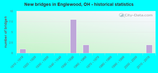
- New bridges - historical statistics
- 11910-1919
- 81950-1959
- 21960-1969
- 22010-2019
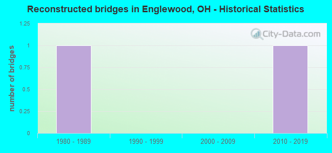
- Reconstructed bridges - Historical Statistics
- 11980-1989
- 01990-1999
- 02000-2009
- 12010-2019
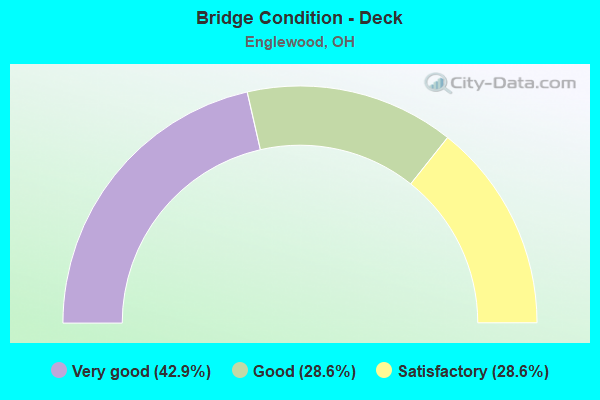
- Bridge Condition - Deck
- 42.9%Very good
- 28.6%Good
- 28.6%Satisfactory
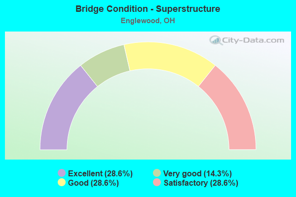
- Bridge Condition - Superstructure
- 28.6%Excellent
- 14.3%Very good
- 28.6%Good
- 28.6%Satisfactory
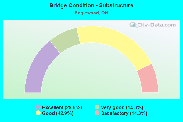
- Bridge Condition - Substructure
- 28.6%Excellent
- 14.3%Very good
- 42.9%Good
- 14.3%Satisfactory
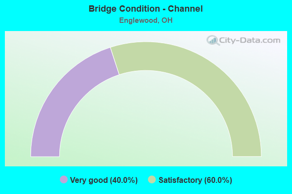
- Bridge Condition - Channel
- 40.0%Very good
- 60.0%Satisfactory
Find on map >> Show street view
Structure Number: 5703336, Location: .01MI.E. OF JCT. SR-48 (Lat: 39.866931, Lng: -84.289300), Route carried "on" structure: US 40, Year Built: 1969, Status: Open, Structure Length: 5.06m (16.60ft), Average Daily Traffic: 7,470 (year 2015), Truck Traffic: 6%, Average Future Daily Traffic: 10,368 (year 2035), Design Load: HS 20+Mod, Features Intersected: ENGLEWOOD SPILLWAY
Minimum Vertical Clearance: 30+ m (98+ ft), Kilometerpoint: 17.397, Lanes on structure: 2, Owner: State Highway Agency, Approaching Roadway Width: 9.0m (29.5ft), Material/Design: Steel continuous, Design/Construction: Stringer/Multi-beam, Number Of Spans In Main Unit: 2, Length of Maximum Span: 34.4m (112.9ft), Curb-To-Curb Width: 8.5m (27.9ft), Out-to-Out Width: 10.2m (33.5ft)
Condition: Deck: Good, Superstructure: Satisfactory, Substructure: Good, Channel: Satisfactory, Operating Rating: 51.8 metric tons, Method Used To Determine Operating Rating: Load Factor (LF) rating reported by rating factor (RF) method using MS18 loading, Inventory Rating: 32.4 metric tons, Method Used To Determine Inventory Rating: Load Factor (LF) rating reported by rating factor (RF) method using MS18 loading, Structural Evaluation: Equal to present minimum criteria, Deck Geometry: High priority of replacement, Waterway Adequacy: Superior to present desirable criteria, Approach Roadway Alignment: Equal to present desirable criteria, Designated Inspection Frequency: Every 12 months, Inspection Date: November 2021, Deck Structure Type: Concrete Cast-file-Place, Wearing Surface/Protective System: Wearing Surface: Integral Concrete
Find on map >> Show street view
Structure Number: 570336, Location: .33MI.E. OF JCT. SR-48 (Lat: 39.869981, Lng: -84.284931), Route carried "on" structure: US 40, Year Built: 1919, Status: Open, Structure Length: 1.07m (3.51ft), Average Daily Traffic: 7,470 (year 2015), Truck Traffic: 6%, Average Future Daily Traffic: 10,368 (year 2035), Design Load: H 15, Features Intersected: STILLWATER RIVER
Minimum Vertical Clearance: 30+ m (98+ ft), Kilometerpoint: 17.928, Lanes on structure: 2, Owner: State Highway Agency, Approaching Roadway Width: 7.3m (24.0ft), Skew: 2 degrees, Material/Design: Concrete, Design/Construction: Culvert, Number Of Spans In Main Unit: 2, Length of Maximum Span: 4.0m (13.1ft)
Condition: Channel: Satisfactory, Culverts: Satisfactory, Operating Rating: 97.2 metric tons, Method Used To Determine Operating Rating: Load Factor (LF) rating reported by rating factor (RF) method using MS18 loading, Inventory Rating: 68.0 metric tons, Method Used To Determine Inventory Rating: Load Factor (LF) rating reported by rating factor (RF) method using MS18 loading, Structural Evaluation: Equal to present minimum criteria, Waterway Adequacy: Superior to present desirable criteria, Approach Roadway Alignment: Superior to present desirable criteria, Designated Inspection Frequency: Every 12 months, Inspection Date: November 2021
Find on map >> Show street view
Structure Number: 5704324, Location: 1.36MI.S. OF JCT. IR-70 (Lat: 39.847611, Lng: -84.323950), Route carried "on" structure: State highway 49, Year Built: 1965, Status: Open, Structure Length: 2.04m (6.69ft), Average Daily Traffic: 11,157 (year 2015), Truck Traffic: 12%, Average Future Daily Traffic: 15,486 (year 2035), Design Load: H 20, Features Intersected: TRIB N BRANCH WOLF CREEK
Minimum Vertical Clearance: 30+ m (98+ ft), Kilometerpoint: 13.036, Lanes on structure: 4, Base Highway Network: Yes, Owner: State Highway Agency, Approaching Roadway Width: 26.8m (87.9ft), Skew: 21 degrees, Material/Design: Concrete continuous, Design/Construction: Slab, Number Of Spans In Main Unit: 3, Length of Maximum Span: 7.6m (24.9ft), Curb-To-Curb Width: 26.8m (87.9ft), Out-to-Out Width: 26.8m (87.9ft)
Condition: Deck: Satisfactory, Superstructure: Satisfactory, Substructure: Satisfactory, Channel: Very good, Operating Rating: 51.8 metric tons, Method Used To Determine Operating Rating: Load Factor (LF) rating reported by rating factor (RF) method using MS18 loading, Inventory Rating: 32.4 metric tons, Method Used To Determine Inventory Rating: Load Factor (LF) rating reported by rating factor (RF) method using MS18 loading, Structural Evaluation: Equal to present minimum criteria, Deck Geometry: Superior to present desirable criteria, Waterway Adequacy: Equal to present desirable criteria, Approach Roadway Alignment: Better than present minimum criteria, Designated Inspection Frequency: Every 12 months, Inspection Date: October 2021, Deck Structure Type: Concrete Cast-file-Place, Wearing Surface/Protective System: Wearing Surface: Bituminous
Find on map >> Show street view
Structure Number: 5704359, Location: JCT. IR-70 (Lat: 39.854511, Lng: -84.337350), Route carried "on" structure: State highway 49, Year Built: 1959, Status: Open, Structure Length: 9.97m (32.71ft), Average Daily Traffic: 3,706 (year 2015), Truck Traffic: 15%, Average Future Daily Traffic: 5,144 (year 2035), Design Load: HS 20+Mod, Features Intersected: I70
Minimum Vertical Clearance: 30+ m (98+ ft), Kilometerpoint: 14.452, Lanes on structure: 2, Lanes under structure: 4, Base Highway Network: Yes (, Subroute: 1), Owner: State Highway Agency, Approaching Roadway Width: 9.8m (32.2ft), Skew: 3 degrees, Material/Design: Steel continuous, Design/Construction: Stringer/Multi-beam, Number Of Spans In Main Unit: 4, Length of Maximum Span: 26.2m (86.0ft), Curb-To-Curb Width: 11.9m (39.0ft), Out-to-Out Width: 12.8m (42.0ft)
Condition: Deck: Very good, Superstructure: Very good, Substructure: Very good, Operating Rating: 58.3 metric tons, Method Used To Determine Operating Rating: Load and Resistance Factor Rating (LRFR) rating reported by rating factor(RF) method using HL-93 loadings, Inventory Rating: 45.4 metric tons, Method Used To Determine Inventory Rating: Load and Resistance Factor Rating (LRFR) rating reported by rating factor(RF) method using HL-93 loadings, Structural Evaluation: Equal to present desirable criteria, Deck Geometry: Better than present minimum criteria, Underclear: Somewhat better than minimum adequacy, Approach Roadway Alignment: Equal to present desirable criteria, Designated Inspection Frequency: Every 24 months, Inspection Date: August 2021, Deck Structure Type: Concrete Cast-file-Place, Wearing Surface/Protective System: Wearing Surface: Latex Concrete, Deck Protection: Epoxy Coated Reinforcing
Find on map >> Show street view
Structure Number: 5705371, Location: .38MI.E. OF JCT. NB-SR-49 (Lat: 39.854781, Lng: -84.330511), Route carried "on" structure: County highway T0027, Year Built: 1959, Year Reconstructed: 1993, Status: Open, Structure Length: 6.89m (22.60ft), Average Daily Traffic: 3,160 (year 2015), Truck Traffic: 5%, Average Future Daily Traffic: 61,976 (year 2035), Design Load: HS 20+Mod, Features Intersected: I70, Facility Carried by Structure: HOKE RD. (T27)
Minimum Vertical Clearance: 30+ m (98+ ft), Kilometerpoint: 22.853, Lanes on structure: 2, Lanes under structure: 4, Owner: State Highway Agency, Approaching Roadway Width: 7.3m (24.0ft), Material/Design: Steel continuous, Design/Construction: Stringer/Multi-beam, Number Of Spans In Main Unit: 4, Length of Maximum Span: 20.4m (66.9ft), Curb-To-Curb Width: 13.1m (43.0ft), Out-to-Out Width: 14.1m (46.3ft)
Condition: Deck: Good, Superstructure: Good, Substructure: Good, Operating Rating: 42.1 metric tons, Method Used To Determine Operating Rating: Allowable Stress (AS) rating reported by rating factor (RF) method using MS18 loading, Inventory Rating: 32.4 metric tons, Method Used To Determine Inventory Rating: Allowable Stress (AS) rating reported by rating factor (RF) method using MS18 loading, Structural Evaluation: Better than present minimum criteria, Deck Geometry: Equal to present minimum criteria, Underclear: Somewhat better than minimum adequacy, Approach Roadway Alignment: Equal to present desirable criteria, Designated Inspection Frequency: Every 24 months, Inspection Date: August 2021, Deck Structure Type: Concrete Cast-file-Place, Wearing Surface/Protective System: Wearing Surface: Monolithic Concrete, Deck Protection: Epoxy Coated Reinforcing
Find on map >> Show street view
Structure Number: 5705401, Location: .79MI.E. OF JCT. NB-SR-49 (Lat: 39.855089, Lng: -84.322939), Route carried "on" structure: Interstate 70, Year Built: 1959, Status: Open, Structure Length: 0.98m (3.22ft), Average Daily Traffic: 52,507 (year 2015), Truck Traffic: 24%, Average Future Daily Traffic: 72,880 (year 2035), Design Load: H 20, Features Intersected: TRIB N BRANCH WOLF CREEK
Minimum Vertical Clearance: 30+ m (98+ ft), Kilometerpoint: 14.484, Lanes on structure: 4, Base Highway Network: Yes, Owner: State Highway Agency, Approaching Roadway Width: 36.6m (120.1ft), Material/Design: Steel, Design/Construction: Culvert, Number Of Spans In Main Unit: 2, Length of Maximum Span: 4.0m (13.1ft)
Condition: Channel: Satisfactory, Culverts: Satisfactory, Operating Rating: 42.1 metric tons, Method Used To Determine Operating Rating: Load Factor (LF) rating reported by rating factor (RF) method using MS18 loading, Inventory Rating: 32.4 metric tons, Method Used To Determine Inventory Rating: Load Factor (LF) rating reported by rating factor (RF) method using MS18 loading, Structural Evaluation: Equal to present minimum criteria, Waterway Adequacy: Superior to present desirable criteria, Approach Roadway Alignment: Superior to present desirable criteria, Designated Inspection Frequency: Every 12 months, Inspection Date: August 2021
Find on map >> Show street view
Structure Number: 5705436, Location: 1.41MI.E.OF JCT. NB-SR-49 (Lat: 39.854800, Lng: -84.311311), Route carried "on" structure: County highway C0025, Year Built: 1959, Status: Open, Structure Length: 6.52m (21.39ft), Average Daily Traffic: 938 (year 2015), Truck Traffic: 2%, Average Future Daily Traffic: 72,880 (year 2035), Design Load: H 15, Features Intersected: I70, Facility Carried by Structure: UNION RD. (C25)
Minimum Vertical Clearance: 30+ m (98+ ft), Kilometerpoint: 27.520, Lanes on structure: 2, Lanes under structure: 4, Owner: State Highway Agency, Approaching Roadway Width: 7.3m (24.0ft), Material/Design: Steel continuous, Design/Construction: Stringer/Multi-beam, Number Of Spans In Main Unit: 4, Length of Maximum Span: 19.2m (63.0ft), Curb-To-Curb Width: 8.5m (27.9ft), Out-to-Out Width: 10.6m (34.8ft)
Condition: Deck: Satisfactory, Superstructure: Good, Substructure: Good, Operating Rating: 35.6 metric tons, Method Used To Determine Operating Rating: Load and Resistance Factor Rating (LRFR) rating reported by rating factor(RF) method using HL-93 loadings, Inventory Rating: 29.2 metric tons, Method Used To Determine Inventory Rating: Load and Resistance Factor Rating (LRFR) rating reported by rating factor(RF) method using HL-93 loadings, Structural Evaluation: Better than present minimum criteria, Deck Geometry: Somewhat better than minimum adequacy, Underclear: Meets minimum limits, Approach Roadway Alignment: Equal to present desirable criteria, Designated Inspection Frequency: Every 12 months, Inspection Date: August 2021, Deck Structure Type: Concrete Cast-file-Place, Wearing Surface/Protective System: Wearing Surface: Latex Concrete
Find on map >> Show street view
Structure Number: 5705533, Location: JCT. SR-48 (Lat: 39.858619, Lng: -84.280381), Route carried "on" structure: Interstate 70, Year Built: 2015, Status: Open, Structure Length: 3.48m (11.42ft), Average Daily Traffic: 45,057 (year 2015), Truck Traffic: 24%, Average Future Daily Traffic: 62,539 (year 2035), Design Load: HL 93, Features Intersected: SR 48
Minimum Vertical Clearance: 30+ m (98+ ft), Kilometerpoint: 18.186, Lanes on structure: 7, Lanes under structure: 6, Base Highway Network: Yes, Owner: State Highway Agency, Approaching Roadway Width: 18.2m (59.7ft), Skew: 32 degrees, Material/Design: Prestressed concrete, Design/Construction: Stringer/Multi-beam, Number Of Spans In Main Unit: 1, Length of Maximum Span: 33.5m (109.9ft), Curb-To-Curb Width: 42.8m (140.4ft), Out-to-Out Width: 44.9m (147.3ft)
Condition: Deck: Very good, Superstructure: Excellent, Substructure: Excellent, Operating Rating: 74.5 metric tons, Method Used To Determine Operating Rating: Load and Resistance Factor Rating (LRFR) rating reported by rating factor(RF) method using HL-93 loadings, Inventory Rating: 38.9 metric tons, Method Used To Determine Inventory Rating: Load and Resistance Factor Rating (LRFR) rating reported by rating factor(RF) method using HL-93 loadings, Structural Evaluation: Superior to present desirable criteria, Deck Geometry: Superior to present desirable criteria, Underclear: Somewhat better than minimum adequacy, Approach Roadway Alignment: Equal to present desirable criteria, Designated Inspection Frequency: Every 24 months, Inspection Date: August 2021, Deck Structure Type: Concrete Cast-file-Place, Wearing Surface/Protective System: Wearing Surface: Monolithic Concrete, Deck Protection: Epoxy Coated Reinforcing
Find on map >> Show street view
Structure Number: 5705584, Location: .62MI.E. OF JCT. SR-48 (Lat: 39.861269, Lng: -84.269319), Route carried "on" structure: Interstate 70, Year Built: 1958, Year Reconstructed: 2015, Status: Open, Structure Length: 8.32m (27.30ft), Average Daily Traffic: 64,298 (year 2015), Truck Traffic: 24%, Average Future Daily Traffic: 89,246 (year 2035), Design Load: HS 20+Mod, Features Intersected: STILLWATER RIVER
Minimum Vertical Clearance: 30+ m (98+ ft), Kilometerpoint: 19.183, Lanes on structure: 6, Base Highway Network: Yes, Owner: State Highway Agency, Approaching Roadway Width: 36.3m (119.1ft), Skew: 31 degrees, Material/Design: Steel continuous, Design/Construction: Stringer/Multi-beam, Number Of Spans In Main Unit: 4, Length of Maximum Span: 22.9m (75.1ft), Curb-To-Curb Width: 36.3m (119.1ft), Out-to-Out Width: 38.5m (126.3ft)
Condition: Deck: Very good, Superstructure: Excellent, Substructure: Excellent, Channel: Very good, Operating Rating: 42.1 metric tons, Method Used To Determine Operating Rating: Load and Resistance Factor Rating (LRFR) rating reported by rating factor(RF) method using HL-93 loadings, Inventory Rating: 32.4 metric tons, Method Used To Determine Inventory Rating: Load and Resistance Factor Rating (LRFR) rating reported by rating factor(RF) method using HL-93 loadings, Structural Evaluation: Equal to present desirable criteria, Deck Geometry: Superior to present desirable criteria, Waterway Adequacy: Superior to present desirable criteria, Approach Roadway Alignment: Superior to present desirable criteria, Designated Inspection Frequency: Every 24 months, Inspection Date: August 2021, Deck Structure Type: Concrete Cast-file-Place, Wearing Surface/Protective System: Wearing Surface: Monolithic Concrete, Deck Protection: Epoxy Coated Reinforcing
Find on map >> Show street view
Structure Number: 5704359, Location: JCT. IR-70 (Lat: 39.854511, Lng: -84.337350), Route carried "under" structure: Interstate 70, Year Built: 1959, Structure Length: 0. m, Average Daily Traffic: 44,651 (year 2015), Truck Traffic: 24%, Features Intersected: S49*N, Facility Carried by Structure: NB SR-49
Minimum Vertical Clearance: 4.93m (16.17ft), Kilometerpoint: 13.213, Lanes on structure: 2, Lanes under structure: 4, Material/Design: Steel continuous, Design/Construction: Stringer/Multi-beam, Length of Maximum Span: 26.2m (86.0ft)
Find on map >> Show street view
Structure Number: 5705371, Location: .38MI.E. OF JCT. NB-SR-49 (Lat: 39.854781, Lng: -84.330511), Route carried "under" structure: Interstate 70, Year Built: 1959, Structure Length: 0. m, Average Daily Traffic: 44,651 (year 2015), Truck Traffic: 24%, Features Intersected: T27(HOKE ROAD), Facility Carried by Structure: HOKE RD. (T27)
Minimum Vertical Clearance: 4.93m (16.17ft), Kilometerpoint: 13.824, Lanes on structure: 2, Lanes under structure: 4, Material/Design: Steel continuous, Design/Construction: Stringer/Multi-beam, Length of Maximum Span: 20.4m (66.9ft)
Find on map >> Show street view
Structure Number: 5705436, Location: 1.41MI.E.OF JCT. NB-SR-49 (Lat: 39.854800, Lng: -84.311311), Route carried "under" structure: Interstate 70, Year Built: 1959, Structure Length: 0. m, Average Daily Traffic: 52,507 (year 2015), Truck Traffic: 24%, Features Intersected: C25(UNION ROAD), Facility Carried by Structure: UNION RD. (C25)
Minimum Vertical Clearance: 5.03m (16.50ft), Kilometerpoint: 15.482, Lanes on structure: 2, Lanes under structure: 4, Material/Design: Steel continuous, Design/Construction: Stringer/Multi-beam, Length of Maximum Span: 19.2m (63.0ft)
Find on map >> Show street view
Structure Number: 5705533, Location: JCT. SR-48 (Lat: 39.858619, Lng: -84.280381), Route carried "under" structure: State highway 48, Year Built: 2015, Structure Length: 0. m, Average Daily Traffic: 26,439 (year 2015), Truck Traffic: 3%, Features Intersected: 00048, Facility Carried by Structure: IR 70
Minimum Vertical Clearance: 5.03m (16.50ft), Kilometerpoint: 34.762, Lanes on structure: 7, Lanes under structure: 6, Material/Design: Prestressed concrete, Design/Construction: Stringer/Multi-beam, Length of Maximum Span: 33.5m (109.9ft)