Bridge Statistics for Enfield, Illinois (IL)
Condition, Traffic, Stress, Structural Evaluation, Project Costs
- National Bridge Inventory (NBI) Statistics
- 25Number of bridges
- 138ft / 41.8mTotal length
- $72,000Total costs
- 12,055Total average daily traffic
- 2,039Total average daily truck traffic
- 12,709Total future (year 2032) average daily traffic
- National Bridge Inventory (NBI) Registered Bridges for Enfield
- No street view available for this location
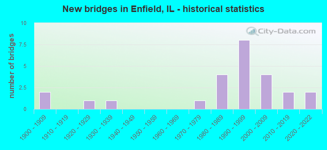
- New bridges - historical statistics
- 21900-1909
- 11920-1929
- 11930-1939
- 11970-1979
- 41980-1989
- 81990-1999
- 42000-2009
- 22010-2019
- 22020-2022

- Reconstructed bridges - Historical Statistics
- 11970-1979
- 11980-1989


- Bridge Condition - Deck
- 10.0%Excellent
- 30.0%Very good
- 10.0%Good
- 40.0%Satisfactory
- 5.0%Fair
- 5.0%Poor

- Bridge Condition - Superstructure
- 10.0%Excellent
- 30.0%Very good
- 5.0%Good
- 45.0%Satisfactory
- 5.0%Fair
- 5.0%Poor

- Bridge Condition - Substructure
- 10.0%Excellent
- 75.0%Very good
- 10.0%Satisfactory
- 5.0%Fair

- Bridge Condition - Channel
- 45.8%Very good
- 16.7%Good
- 25.0%Satisfactory
- 12.5%Fair

- Bridge Condition - Culverts
- 20.0%Good
- 20.0%Satisfactory
- 40.0%Fair
- 20.0%Poor
Find on map >> Show street view
Structure Number: 333223, Location: 3 MI N DOLAN LAKE (Lat: 38.104789, Lng: -88.391039), Route carried "on" structure: County highway , Year Built: 1983, Status: Open, Structure Length: 1.28m (4.20ft), Average Daily Traffic: 25 (year 2017), Truck Traffic: 12%, Average Future Daily Traffic: 25 (year 2032), Design Load: HS 20, Features Intersected: TRIB LOST BRANCH, Facility Carried by Structure: TR-482
Minimum Vertical Clearance: 30+ m (98+ ft), Kilometerpoint: 1.674, Lanes on structure: 2, Owner: Town or Township Highway Agency, Approaching Roadway Width: 6.1m (20.0ft), Material/Design: Prestressed concrete, Design/Construction: Box Beam or Girders - Multiple, Number Of Spans In Main Unit: 1, Length of Maximum Span: 11.6m (38.1ft), Curb-To-Curb Width: 7.3m (24.0ft), Out-to-Out Width: 7.3m (24.0ft)
Condition: Deck: Very good, Superstructure: Very good, Substructure: Very good, Channel: Satisfactory, Operating Rating: 44.4 metric tons, Method Used To Determine Operating Rating: Assigned rating based on Load Factor Design (LFD) reported by rating factor (RF) using MS18 loading, Inventory Rating: 32.4 metric tons, Method Used To Determine Inventory Rating: Assigned rating based on Load Factor Design (LFD) reported by rating factor (RF) using MS18 loading, Structural Evaluation: Equal to present desirable criteria, Deck Geometry: Equal to present minimum criteria, Waterway Adequacy: Equal to present desirable criteria, Approach Roadway Alignment: Equal to present minimum criteria, Designated Inspection Frequency: Every 48 months, Inspection Date: Febuary 2019, Deck Structure Type: Concrete Precast Panels
Find on map >> Show street view
Structure Number: 333236, Location: 2 MI N DOLAN LAKE (Lat: 38.096094, Lng: -88.391031), Route carried "on" structure: County highway , Year Built: 1990, Status: Open, Structure Length: 1.89m (6.20ft), Average Daily Traffic: 25 (year 2017), Truck Traffic: 12%, Average Future Daily Traffic: 25 (year 2032), Design Load: HS 20, Features Intersected: TRIB LOST CREEK DRAI, Facility Carried by Structure: TR 482
Minimum Vertical Clearance: 30+ m (98+ ft), Kilometerpoint: 2.639, Lanes on structure: 2, Owner: Town or Township Highway Agency, Approaching Roadway Width: 3.7m (12.1ft), Skew: 3 degrees, Material/Design: Prestressed concrete, Design/Construction: Box Beam or Girders - Multiple, Number Of Spans In Main Unit: 1, Length of Maximum Span: 17.9m (58.7ft), Curb-To-Curb Width: 7.4m (24.3ft), Out-to-Out Width: 7.4m (24.3ft)
Condition: Deck: Very good, Superstructure: Very good, Substructure: Very good, Channel: Very good, Operating Rating: 44.4 metric tons, Method Used To Determine Operating Rating: Assigned rating based on Load Factor Design (LFD) reported by rating factor (RF) using MS18 loading, Inventory Rating: 32.4 metric tons, Method Used To Determine Inventory Rating: Assigned rating based on Load Factor Design (LFD) reported by rating factor (RF) using MS18 loading, Structural Evaluation: Equal to present desirable criteria, Deck Geometry: Equal to present minimum criteria, Waterway Adequacy: Equal to present desirable criteria, Approach Roadway Alignment: Better than present minimum criteria, Designated Inspection Frequency: Every 48 months, Inspection Date: Febuary 2019, Deck Structure Type: Concrete Precast Panels
Find on map >> Show street view
Structure Number: 333253, Location: 3.5 MI S BUNGAY (Lat: 38.134883, Lng: -88.395225), Route carried "on" structure: County highway , Year Built: 1994, Status: Open, Structure Length: 1.87m (6.14ft), Average Daily Traffic: 25 (year 2017), Truck Traffic: 12%, Average Future Daily Traffic: 25 (year 2032), Design Load: HS 20, Features Intersected: CREEK, Facility Carried by Structure: TR-470
Minimum Vertical Clearance: 30+ m (98+ ft), Kilometerpoint: 0.097, Lanes on structure: 2, Owner: Town or Township Highway Agency, Approaching Roadway Width: 5.5m (18.0ft), Material/Design: Prestressed concrete, Design/Construction: Box Beam or Girders - Multiple, Number Of Spans In Main Unit: 1, Length of Maximum Span: 17.8m (58.4ft), Curb-To-Curb Width: 7.3m (24.0ft), Out-to-Out Width: 7.3m (24.0ft)
Condition: Deck: Very good, Superstructure: Very good, Substructure: Very good, Channel: Very good, Operating Rating: 44.4 metric tons, Method Used To Determine Operating Rating: Assigned rating based on Load Factor Design (LFD) reported by rating factor (RF) using MS18 loading, Inventory Rating: 32.4 metric tons, Method Used To Determine Inventory Rating: Assigned rating based on Load Factor Design (LFD) reported by rating factor (RF) using MS18 loading, Structural Evaluation: Equal to present desirable criteria, Deck Geometry: Equal to present minimum criteria, Waterway Adequacy: Superior to present desirable criteria, Approach Roadway Alignment: Equal to present desirable criteria, Designated Inspection Frequency: Every 48 months, Inspection Date: March 2020, Deck Structure Type: Concrete Precast Panels
Find on map >> Show street view
Structure Number: 3333, Location: 2 MI NE DOLAN LAKE (Lat: 38.094556, Lng: -88.383378), Route carried "on" structure: County highway , Year Built: 2007, Status: Open, Structure Length: 1.58m (5.18ft), Average Daily Traffic: 50 (year 2017), Truck Traffic: 14%, Average Future Daily Traffic: 50 (year 2032), Features Intersected: LOST CREEK, Facility Carried by Structure: TR-173
Minimum Vertical Clearance: 30+ m (98+ ft), Kilometerpoint: 17.815, Lanes on structure: 2, Owner: Town or Township Highway Agency, Approaching Roadway Width: 7.3m (24.0ft), Skew: 4 degrees, Material/Design: Prestressed concrete, Design/Construction: Box Beam or Girders - Multiple, Number Of Spans In Main Unit: 1, Length of Maximum Span: 15.2m (49.9ft), Curb-To-Curb Width: 7.3m (24.0ft), Out-to-Out Width: 7.3m (24.0ft)
Condition: Deck: Very good, Superstructure: Very good, Substructure: Very good, Channel: Very good, Operating Rating: 71.0 metric tons, Method Used To Determine Operating Rating: Load Factor (LF) rating reported by rating factor (RF) method using MS18 loading, Inventory Rating: 42.4 metric tons, Method Used To Determine Inventory Rating: Load Factor (LF) rating reported by rating factor (RF) method using MS18 loading, Structural Evaluation: Equal to present desirable criteria, Deck Geometry: Equal to present minimum criteria, Waterway Adequacy: Equal to present desirable criteria, Approach Roadway Alignment: Equal to present minimum criteria, Designated Inspection Frequency: Every 48 months, Inspection Date: Febuary 2018, Deck Structure Type: Concrete Precast Panels
Find on map >> Show street view
Structure Number: 335006, Location: 1.75 MI N DOLAN LAKE (Lat: 38.093006, Lng: -88.391258), Route carried "on" structure: County highway , Year Built: 1981, Status: Open, Structure Length: 1.18m (3.87ft), Average Daily Traffic: 50 (year 2017), Truck Traffic: 14%, Average Future Daily Traffic: 50 (year 2032), Design Load: HS 20, Features Intersected: TRIB LOST CREEK DRAI, Facility Carried by Structure: TR-173
Minimum Vertical Clearance: 30+ m (98+ ft), Kilometerpoint: 17.026, Lanes on structure: 2, Owner: Town or Township Highway Agency, Approaching Roadway Width: 7.3m (24.0ft), Material/Design: Concrete, Design/Construction: Culvert, Number Of Spans In Main Unit: 3, Length of Maximum Span: 3.9m (12.8ft), Curb-To-Curb Width: 7.3m (24.0ft), Out-to-Out Width: 7.9m (25.9ft)
Condition: Channel: Satisfactory, Culverts: Poor, Operating Rating: 61.6 metric tons, Method Used To Determine Operating Rating: Load Factor (LF) rating reported by rating factor (RF) method using MS18 loading, Inventory Rating: 36.9 metric tons, Method Used To Determine Inventory Rating: Load Factor (LF) rating reported by rating factor (RF) method using MS18 loading, Structural Evaluation: Meets minimum limits, Deck Geometry: Equal to present minimum criteria, Waterway Adequacy: Equal to present desirable criteria, Approach Roadway Alignment: Equal to present minimum criteria, Designated Inspection Frequency: Every 24 months, Other Special Inspection Frequency: Every 12 months, Inspection Date: Febuary 2021, Other Special Inspection Date: Febuary 2021, Deck Structure Type: Concrete Cast-file-Place
Find on map >> Show street view
Structure Number: 970023, Location: 1.5 MI N ENFIELD (Lat: 38.126606, Lng: -88.336564), Route carried "on" structure: US 45, Year Built: 1928, Year Reconstructed: 1978, Status: Open, Structure Length: 1.46m (4.79ft), Average Daily Traffic: 1,900 (year 2021), Truck Traffic: 23%, Average Future Daily Traffic: 2,355 (year 2032), Features Intersected: LOST CREEK
Minimum Vertical Clearance: 30+ m (98+ ft), Kilometerpoint: 152.288, Lanes on structure: 2, Base Highway Network: Yes, Owner: State Highway Agency, Approaching Roadway Width: 7.9m (25.9ft), Material/Design: Concrete, Design/Construction: Tee Beam, Number Of Spans In Main Unit: 1, Length of Maximum Span: 14.0m (45.9ft), Curb-To-Curb Width: 10.0m (32.8ft), Out-to-Out Width: 10.1m (33.1ft)
Condition: Deck: Poor, Superstructure: Poor, Substructure: Satisfactory, Channel: Fair, Operating Rating: 45.4 metric tons, Method Used To Determine Operating Rating: Load Factor (LF) rating reported by rating factor (RF) method using MS18 loading, Inventory Rating: 26.6 metric tons, Method Used To Determine Inventory Rating: Load Factor (LF) rating reported by rating factor (RF) method using MS18 loading, Structural Evaluation: Meets minimum limits, Deck Geometry: Somewhat better than minimum adequacy, Waterway Adequacy: Equal to present minimum criteria, Approach Roadway Alignment: Equal to present desirable criteria, Designated Inspection Frequency: Every 12 months, Inspection Date: June 2021, Deck Structure Type: Concrete Cast-file-Place, Wearing Surface/Protective System: Wearing Surface: Bituminous, Membrane: Built-up
Find on map >> Show street view
Structure Number: 970024, Location: ENFIELD (Lat: 38.097750, Lng: -88.337836), Route carried "on" structure: US 45, Year Built: 1939, Year Reconstructed: 1992, Status: Open, Structure Length: 3.54m (11.61ft), Average Daily Traffic: 3,000 (year 2021), Truck Traffic: 14%, Average Future Daily Traffic: 2,355 (year 2032), Design Load: HS 20, Features Intersected: L & N RR
Minimum Vertical Clearance: 30+ m (98+ ft), Kilometerpoint: 149.021, Lanes on structure: 2, Base Highway Network: Yes, Owner: State Highway Agency, Approaching Roadway Width: 9.6m (31.5ft), Material/Design: Steel continuous, Design/Construction: Stringer/Multi-beam, Number Of Spans In Main Unit: 3, Length of Maximum Span: 13.4m (44.0ft), Curb or Sidewalk Widths: Left: 0.0m, Right: 1.2m (3.9ft), Curb-To-Curb Width: 9.8m (32.2ft), Out-to-Out Width: 11.6m (38.1ft)
Condition: Deck: Fair, Superstructure: Fair, Substructure: Satisfactory, Operating Rating: 65.4 metric tons, Method Used To Determine Operating Rating: Load Factor (LF) rating reported by rating factor (RF) method using MS18 loading, Inventory Rating: 39.2 metric tons, Method Used To Determine Inventory Rating: Load Factor (LF) rating reported by rating factor (RF) method using MS18 loading, Structural Evaluation: Somewhat better than minimum adequacy, Deck Geometry: Meets minimum limits, Underclear: Somewhat better than minimum adequacy, Approach Roadway Alignment: Equal to present desirable criteria, Designated Inspection Frequency: Every 24 months, Inspection Date: October 2021, Deck Structure Type: Concrete Cast-file-Place, Wearing Surface/Protective System: Deck Protection: Epoxy Coated Reinforcing
Find on map >> Show street view
Structure Number: 970063, Location: 2 MI N ENFIELD (Lat: 38.132786, Lng: -88.336508), Route carried "on" structure: US 45, Year Built: 1978, Status: Open, Structure Length: 0.98m (3.22ft), Average Daily Traffic: 1,900 (year 2021), Truck Traffic: 23%, Average Future Daily Traffic: 2,355 (year 2032), Design Load: HS 20, Features Intersected: DRAINAGE DITCH
Minimum Vertical Clearance: 30+ m (98+ ft), Kilometerpoint: 152.980, Lanes on structure: 2, Base Highway Network: Yes, Owner: State Highway Agency, Approaching Roadway Width: 7.3m (24.0ft), Material/Design: Concrete continuous, Design/Construction: Culvert, Number Of Spans In Main Unit: 3, Length of Maximum Span: 3.3m (10.8ft), Curb-To-Curb Width: 13.0m (42.7ft), Out-to-Out Width: 13.6m (44.6ft)
Condition: Channel: Satisfactory, Culverts: Satisfactory, Operating Rating: 50.5 metric tons, Method Used To Determine Operating Rating: Load Factor (LF) rating reported by rating factor (RF) method using MS18 loading, Inventory Rating: 30.1 metric tons, Method Used To Determine Inventory Rating: Load Factor (LF) rating reported by rating factor (RF) method using MS18 loading, Structural Evaluation: Equal to present minimum criteria, Deck Geometry: Better than present minimum criteria, Waterway Adequacy: Meets minimum limits, Approach Roadway Alignment: Equal to present desirable criteria, Designated Inspection Frequency: Every 24 months, Inspection Date: September 2020, Deck Structure Type: Concrete Cast-file-Place, Wearing Surface/Protective System: Wearing Surface: Bituminous, Membrane: Built-up
Find on map >> Show street view
Structure Number: 970068, Location: 3 MI E ENFIELD JCT (Lat: 38.082656, Lng: -88.284039), Route carried "on" structure: State highway 14, Year Built: 1996, Status: Open, Structure Length: 1.94m (6.36ft), Average Daily Traffic: 2,800 (year 2021), Truck Traffic: 10%, Average Future Daily Traffic: 3,006 (year 2032), Design Load: HS 20, Features Intersected: SEVEN MILE CREEK
Minimum Vertical Clearance: 30+ m (98+ ft), Kilometerpoint: 88.367, Lanes on structure: 2, Base Highway Network: Yes, Owner: State Highway Agency, Approaching Roadway Width: 7.9m (25.9ft), Material/Design: Steel, Design/Construction: Stringer/Multi-beam, Number Of Spans In Main Unit: 1, Length of Maximum Span: 18.6m (61.0ft), Curb-To-Curb Width: 9.8m (32.2ft), Out-to-Out Width: 10.7m (35.1ft)
Condition: Deck: Good, Superstructure: Satisfactory, Substructure: Very good, Channel: Good, Operating Rating: 87.2 metric tons, Method Used To Determine Operating Rating: Load Factor (LF) rating reported by rating factor (RF) method using MS18 loading, Inventory Rating: 52.2 metric tons, Method Used To Determine Inventory Rating: Load Factor (LF) rating reported by rating factor (RF) method using MS18 loading, Structural Evaluation: Equal to present minimum criteria, Deck Geometry: Meets minimum limits, Waterway Adequacy: Equal to present desirable criteria, Approach Roadway Alignment: Equal to present desirable criteria, Designated Inspection Frequency: Every 24 months, Inspection Date: August 2021, Deck Structure Type: Concrete Cast-file-Place, Wearing Surface/Protective System: Deck Protection: Epoxy Coated Reinforcing
Find on map >> Show street view
Structure Number: 972012, Location: 1.5 MI S ENFIELD JCT (Lat: 38.062192, Lng: -88.337419), Route carried "on" structure: US 45, Year Built: 2006, Status: Open, Structure Length: 0.81m (2.66ft), Average Daily Traffic: 1,700 (year 2021), Truck Traffic: 21%, Average Future Daily Traffic: 1,653 (year 2032), Design Load: HS 20, Features Intersected: SEVEN MILE CREEK
Minimum Vertical Clearance: 30+ m (98+ ft), Kilometerpoint: 145.111, Lanes on structure: 2, Base Highway Network: Yes, Owner: State Highway Agency, Approaching Roadway Width: 9.1m (29.9ft), Skew: 4 degrees, Material/Design: Concrete continuous, Design/Construction: Culvert, Number Of Spans In Main Unit: 2, Length of Maximum Span: 3.7m (12.1ft)
Condition: Channel: Good, Culverts: Good, Operating Rating: 66.1 metric tons, Method Used To Determine Operating Rating: Load Factor (LF) rating reported by rating factor (RF) method using MS18 loading, Inventory Rating: 39.5 metric tons, Method Used To Determine Inventory Rating: Load Factor (LF) rating reported by rating factor (RF) method using MS18 loading, Structural Evaluation: Better than present minimum criteria, Waterway Adequacy: Equal to present desirable criteria, Approach Roadway Alignment: Equal to present desirable criteria, Designated Inspection Frequency: Every 48 months, Inspection Date: January 2022, Deck Structure Type: Concrete Cast-file-Place
Find on map >> Show street view
Structure Number: 973166, Location: 2.5 MI ESE ENFIELD (Lat: 38.083694, Lng: -88.282242), Route carried "on" structure: County highway , Year Built: 1983, Status: Open, Structure Length: 1.89m (6.20ft), Average Daily Traffic: 75 (year 2019), Truck Traffic: 33%, Average Future Daily Traffic: 125 (year 2032), Design Load: HS 20, Features Intersected: SEVENMILE CREEK, Facility Carried by Structure: CH-12
Minimum Vertical Clearance: 30+ m (98+ ft), Kilometerpoint: 9.865, Lanes on structure: 2, Owner: County Highway Agency, Approaching Roadway Width: 11.0m (36.1ft), Material/Design: Prestressed concrete, Design/Construction: Box Beam or Girders - Multiple, Number Of Spans In Main Unit: 1, Length of Maximum Span: 18.0m (59.1ft), Curb-To-Curb Width: 8.7m (28.5ft), Out-to-Out Width: 8.7m (28.5ft)
Condition: Deck: Satisfactory, Superstructure: Satisfactory, Substructure: Fair, Channel: Fair, Operating Rating: 44.4 metric tons, Method Used To Determine Operating Rating: Assigned rating based on Load Factor Design (LFD) reported by rating factor (RF) using MS18 loading, Inventory Rating: 32.4 metric tons, Method Used To Determine Inventory Rating: Assigned rating based on Load Factor Design (LFD) reported by rating factor (RF) using MS18 loading, Structural Evaluation: Somewhat better than minimum adequacy, Deck Geometry: Better than present minimum criteria, Waterway Adequacy: Superior to present desirable criteria, Approach Roadway Alignment: Equal to present desirable criteria, Designated Inspection Frequency: Every 24 months, Inspection Date: January 2021, Deck Structure Type: Concrete Cast-file-Place, Wearing Surface/Protective System: Wearing Surface: Gravel
Find on map >> Show street view
Structure Number: 973182, Location: 2 MI NW ENFIELD (Lat: 38.111019, Lng: -88.372236), Route carried "on" structure: County highway , Year Built: 1984, Status: Open, Structure Length: 2.35m (7.71ft), Average Daily Traffic: 25 (year 2019), Truck Traffic: 12%, Average Future Daily Traffic: 50 (year 2032), Design Load: HS 20, Features Intersected: LOST CREEK, Facility Carried by Structure: TR-181
Minimum Vertical Clearance: 30+ m (98+ ft), Kilometerpoint: 0.016, Lanes on structure: 2, Owner: Town or Township Highway Agency, Approaching Roadway Width: 6.1m (20.0ft), Skew: 3 degrees, Material/Design: Prestressed concrete, Design/Construction: Box Beam or Girders - Multiple, Number Of Spans In Main Unit: 3, Length of Maximum Span: 7.3m (24.0ft), Curb-To-Curb Width: 7.3m (24.0ft), Out-to-Out Width: 7.3m (24.0ft)
Condition: Deck: Satisfactory, Superstructure: Satisfactory, Substructure: Very good, Channel: Good, Operating Rating: 44.4 metric tons, Method Used To Determine Operating Rating: Assigned rating based on Load Factor Design (LFD) reported by rating factor (RF) using MS18 loading, Inventory Rating: 32.4 metric tons, Method Used To Determine Inventory Rating: Assigned rating based on Load Factor Design (LFD) reported by rating factor (RF) using MS18 loading, Structural Evaluation: Equal to present minimum criteria, Deck Geometry: Equal to present minimum criteria, Waterway Adequacy: Equal to present desirable criteria, Approach Roadway Alignment: Better than present minimum criteria, Designated Inspection Frequency: Every 24 months, Inspection Date: Febuary 2022, Deck Structure Type: Concrete Precast Panels
Find on map >> Show street view
Structure Number: 973207, Location: 3.5 MI SE ENFIELD (Lat: 38.068228, Lng: -88.282467), Route carried "on" structure: County highway , Year Built: 1991, Status: Open, Structure Length: 1.26m (4.13ft), Average Daily Traffic: 10 (year 2019), Average Future Daily Traffic: 25 (year 2032), Design Load: HS 20, Features Intersected: DRAINAGE DITCH, Facility Carried by Structure: TR-219
Minimum Vertical Clearance: 30+ m (98+ ft), Kilometerpoint: 3.170, Lanes on structure: 2, Owner: Town or Township Highway Agency, Approaching Roadway Width: 5.5m (18.0ft), Material/Design: Prestressed concrete, Design/Construction: Box Beam or Girders - Multiple, Number Of Spans In Main Unit: 1, Length of Maximum Span: 11.8m (38.7ft), Curb-To-Curb Width: 8.6m (28.2ft), Out-to-Out Width: 8.6m (28.2ft)
Condition: Deck: Satisfactory, Superstructure: Satisfactory, Substructure: Very good, Channel: Very good, Operating Rating: 44.4 metric tons, Method Used To Determine Operating Rating: Assigned rating based on Load Factor Design (LFD) reported by rating factor (RF) using MS18 loading, Inventory Rating: 32.4 metric tons, Method Used To Determine Inventory Rating: Assigned rating based on Load Factor Design (LFD) reported by rating factor (RF) using MS18 loading, Structural Evaluation: Equal to present minimum criteria, Deck Geometry: Better than present minimum criteria, Waterway Adequacy: Equal to present minimum criteria, Approach Roadway Alignment: Equal to present minimum criteria, Designated Inspection Frequency: Every 24 months, Inspection Date: Febuary 2022, Deck Structure Type: Concrete Precast Panels
Find on map >> Show street view
Structure Number: 973211, Location: 1 MI SE ENFIELD (Lat: 38.086300, Lng: -88.318664), Route carried "on" structure: County highway , Year Built: 1991, Status: Open, Structure Length: 1.26m (4.13ft), Average Daily Traffic: 25 (year 2019), Truck Traffic: 16%, Average Future Daily Traffic: 10 (year 2032), Design Load: HS 20, Features Intersected: TRIB SEVEN MILE CK, Facility Carried by Structure: TR-80
Minimum Vertical Clearance: 30+ m (98+ ft), Kilometerpoint: 0.386, Lanes on structure: 2, Owner: Town or Township Highway Agency, Approaching Roadway Width: 3.0m (9.8ft), Material/Design: Prestressed concrete, Design/Construction: Box Beam or Girders - Multiple, Number Of Spans In Main Unit: 1, Length of Maximum Span: 11.8m (38.7ft), Curb-To-Curb Width: 7.3m (24.0ft), Out-to-Out Width: 7.3m (24.0ft)
Condition: Deck: Satisfactory, Superstructure: Satisfactory, Substructure: Very good, Channel: Very good, Operating Rating: 44.4 metric tons, Method Used To Determine Operating Rating: Assigned rating based on Load Factor Design (LFD) reported by rating factor (RF) using MS18 loading, Inventory Rating: 32.4 metric tons, Method Used To Determine Inventory Rating: Assigned rating based on Load Factor Design (LFD) reported by rating factor (RF) using MS18 loading, Structural Evaluation: Equal to present minimum criteria, Deck Geometry: Equal to present minimum criteria, Waterway Adequacy: Better than present minimum criteria, Approach Roadway Alignment: Better than present minimum criteria, Designated Inspection Frequency: Every 24 months, Inspection Date: Febuary 2022, Deck Structure Type: Concrete Precast Panels
Find on map >> Show street view
Structure Number: 973225, Location: 0.5 MI W ENFIELD (Lat: 38.096978, Lng: -88.361350), Route carried "on" structure: County highway , Year Built: 1993, Status: Open, Structure Length: 1.57m (5.15ft), Average Daily Traffic: 75 (year 2019), Truck Traffic: 8%, Average Future Daily Traffic: 125 (year 2032), Design Load: HS 20, Features Intersected: GOWDY CREEK, Facility Carried by Structure: TR-191
Minimum Vertical Clearance: 30+ m (98+ ft), Kilometerpoint: 1.336, Lanes on structure: 2, Owner: Town or Township Highway Agency, Approaching Roadway Width: 5.5m (18.0ft), Skew: 1 degrees, Material/Design: Prestressed concrete, Design/Construction: Box Beam or Girders - Multiple, Number Of Spans In Main Unit: 1, Length of Maximum Span: 14.8m (48.6ft), Curb-To-Curb Width: 7.3m (24.0ft), Out-to-Out Width: 7.3m (24.0ft)
Condition: Deck: Satisfactory, Superstructure: Satisfactory, Substructure: Very good, Channel: Satisfactory, Operating Rating: 44.1 metric tons, Method Used To Determine Operating Rating: Assigned rating based on Load Factor Design (LFD) reported by rating factor (RF) using MS18 loading, Inventory Rating: 32.4 metric tons, Method Used To Determine Inventory Rating: Assigned rating based on Load Factor Design (LFD) reported by rating factor (RF) using MS18 loading, Structural Evaluation: Equal to present minimum criteria, Deck Geometry: Equal to present minimum criteria, Waterway Adequacy: Better than present minimum criteria, Approach Roadway Alignment: Better than present minimum criteria, Designated Inspection Frequency: Every 24 months, Inspection Date: January 2021, Deck Structure Type: Concrete Precast Panels, Wearing Surface/Protective System: Wearing Surface: Gravel
Find on map >> Show street view
Structure Number: 973228, Location: 3.5 MI SE ENFIELD (Lat: 38.068200, Lng: -88.285072), Route carried "on" structure: County highway , Year Built: 1995, Status: Open, Structure Length: 1.26m (4.13ft), Average Daily Traffic: 10 (year 2019), Average Future Daily Traffic: 25 (year 2032), Design Load: HS 20, Features Intersected: DRAINAGE DITCH, Facility Carried by Structure: TR-219
Minimum Vertical Clearance: 30+ m (98+ ft), Kilometerpoint: 2.945, Lanes on structure: 2, Owner: Town or Township Highway Agency, Approaching Roadway Width: 7.3m (24.0ft), Skew: 1 degrees, Material/Design: Concrete, Design/Construction: Box Beam or Girders - Multiple, Number Of Spans In Main Unit: 1, Length of Maximum Span: 11.9m (39.0ft), Curb-To-Curb Width: 7.3m (24.0ft), Out-to-Out Width: 7.3m (24.0ft)
Condition: Deck: Very good, Superstructure: Very good, Substructure: Very good, Channel: Very good, Operating Rating: 44.1 metric tons, Method Used To Determine Operating Rating: Assigned rating based on Load Factor Design (LFD) reported by rating factor (RF) using MS18 loading, Inventory Rating: 32.4 metric tons, Method Used To Determine Inventory Rating: Assigned rating based on Load Factor Design (LFD) reported by rating factor (RF) using MS18 loading, Structural Evaluation: Equal to present desirable criteria, Deck Geometry: Equal to present minimum criteria, Waterway Adequacy: Equal to present desirable criteria, Approach Roadway Alignment: Equal to present desirable criteria, Designated Inspection Frequency: Every 48 months, Inspection Date: March 2021, Deck Structure Type: Concrete Precast Panels
Find on map >> Show street view
Structure Number: 97324, Location: 3 MI SE SPRINGERTON (Lat: 38.147567, Lng: -88.321608), Route carried "on" structure: County highway , Year Built: 1999, Status: Open, Structure Length: 2.29m (7.51ft), Average Daily Traffic: 25 (year 2019), Truck Traffic: 20%, Average Future Daily Traffic: 25 (year 2032), Design Load: HS 20, Features Intersected: CREEK, Facility Carried by Structure: TR 125
Minimum Vertical Clearance: 30+ m (98+ ft), Kilometerpoint: 1.287, Lanes on structure: 2, Owner: Town or Township Highway Agency, Approaching Roadway Width: 6.1m (20.0ft), Skew: 1 degrees, Material/Design: Prestressed concrete, Design/Construction: Box Beam or Girders - Multiple, Number Of Spans In Main Unit: 3, Length of Maximum Span: 7.6m (24.9ft), Curb-To-Curb Width: 7.3m (24.0ft), Out-to-Out Width: 7.3m (24.0ft)
Condition: Deck: Satisfactory, Superstructure: Satisfactory, Substructure: Very good, Channel: Very good, Operating Rating: 44.1 metric tons, Method Used To Determine Operating Rating: Assigned rating based on Load Factor Design (LFD) reported by rating factor (RF) using MS18 loading, Inventory Rating: 32.4 metric tons, Method Used To Determine Inventory Rating: Assigned rating based on Load Factor Design (LFD) reported by rating factor (RF) using MS18 loading, Structural Evaluation: Equal to present minimum criteria, Deck Geometry: Equal to present minimum criteria, Waterway Adequacy: Equal to present desirable criteria, Approach Roadway Alignment: Equal to present desirable criteria, Designated Inspection Frequency: Every 24 months, Inspection Date: March 2021, Deck Structure Type: Concrete Precast Panels
Find on map >> Show street view
Structure Number: 973242, Location: 1.5 MI N ENFIELD (Lat: 38.125883, Lng: -88.350383), Route carried "on" structure: County highway , Year Built: 2001, Status: Open, Structure Length: 2.94m (9.65ft), Average Daily Traffic: 25 (year 2019), Truck Traffic: 12%, Average Future Daily Traffic: 25 (year 2032), Design Load: HS 20, Features Intersected: DRAINAGE DITCH, Facility Carried by Structure: TR 46
Minimum Vertical Clearance: 30+ m (98+ ft), Kilometerpoint: 2.462, Lanes on structure: 2, Owner: Town or Township Highway Agency, Approaching Roadway Width: 5.5m (18.0ft), Material/Design: Prestressed concrete, Design/Construction: Box Beam or Girders - Multiple, Number Of Spans In Main Unit: 3, Length of Maximum Span: 10.7m (35.1ft), Curb-To-Curb Width: 7.3m (24.0ft), Out-to-Out Width: 7.3m (24.0ft)
Condition: Deck: Satisfactory, Superstructure: Satisfactory, Substructure: Very good, Channel: Satisfactory, Operating Rating: 44.1 metric tons, Method Used To Determine Operating Rating: Assigned rating based on Load Factor Design (LFD) reported by rating factor (RF) using MS18 loading, Inventory Rating: 32.4 metric tons, Method Used To Determine Inventory Rating: Assigned rating based on Load Factor Design (LFD) reported by rating factor (RF) using MS18 loading, Structural Evaluation: Equal to present minimum criteria, Deck Geometry: Equal to present minimum criteria, Waterway Adequacy: Equal to present desirable criteria, Approach Roadway Alignment: Equal to present desirable criteria, Designated Inspection Frequency: Every 24 months, Inspection Date: Febuary 2022, Deck Structure Type: Concrete Precast Panels
Find on map >> Show street view
Structure Number: 973252, Location: 2.5 MI NE ENFIELD (Lat: 38.147853, Lng: -88.308975), Route carried "on" structure: County highway , Year Built: 2009, Status: Open, Structure Length: 1.72m (5.64ft), Average Daily Traffic: 25 (year 2019), Truck Traffic: 20%, Average Future Daily Traffic: 25 (year 2032), Design Load: HS 25 or greater, Features Intersected: BROAD RUN, Facility Carried by Structure: 1850 N
Minimum Vertical Clearance: 30+ m (98+ ft), Kilometerpoint: 2.398, Lanes on structure: 2, Owner: Town or Township Highway Agency, Approaching Roadway Width: 6.7m (22.0ft), Material/Design: Prestressed concrete, Design/Construction: Box Beam or Girders - Multiple, Number Of Spans In Main Unit: 1, Length of Maximum Span: 16.4m (53.8ft), Curb-To-Curb Width: 7.3m (24.0ft), Out-to-Out Width: 7.3m (24.0ft)
Condition: Deck: Good, Superstructure: Good, Substructure: Very good, Channel: Good, Operating Rating: 44.1 metric tons, Method Used To Determine Operating Rating: Assigned rating based on Load Factor Design (LFD) reported by rating factor (RF) using MS18 loading, Inventory Rating: 32.4 metric tons, Method Used To Determine Inventory Rating: Assigned rating based on Load Factor Design (LFD) reported by rating factor (RF) using MS18 loading, Structural Evaluation: Better than present minimum criteria, Deck Geometry: Equal to present minimum criteria, Waterway Adequacy: Equal to present desirable criteria, Approach Roadway Alignment: Equal to present desirable criteria, Designated Inspection Frequency: Every 48 months, Inspection Date: Febuary 2020, Deck Structure Type: Concrete Precast Panels
Find on map >> Show street view
Structure Number: 97327, Location: 2.5 MI NE ENFIELD (Lat: 38.138536, Lng: -88.299992), Route carried "on" structure: County highway , Year Built: 2012, Status: Open, Structure Length: 2.19m (7.19ft), Average Daily Traffic: 25 (year 2019), Truck Traffic: 44%, Average Future Daily Traffic: 50 (year 2032), Design Load: HS 15, Features Intersected: BROAD RUN, Facility Carried by Structure: TR-112
Minimum Vertical Clearance: 30+ m (98+ ft), Kilometerpoint: 3.009, Lanes on structure: 2, Owner: Town or Township Highway Agency, Approaching Roadway Width: 5.5m (18.0ft), Skew: 4 degrees, Material/Design: Prestressed concrete, Design/Construction: Box Beam or Girders - Multiple, Number Of Spans In Main Unit: 1, Length of Maximum Span: 21.2m (69.6ft), Curb-To-Curb Width: 7.3m (24.0ft), Out-to-Out Width: 7.3m (24.0ft)
Condition: Deck: Satisfactory, Superstructure: Satisfactory, Substructure: Very good, Channel: Very good, Operating Rating: 59.3 metric tons, Method Used To Determine Operating Rating: Load and Resistance Factor Rating (LRFR) rating reported by rating factor(RF) method using HL-93 loadings, Inventory Rating: 43.4 metric tons, Method Used To Determine Inventory Rating: Load and Resistance Factor Rating (LRFR) rating reported by rating factor(RF) method using HL-93 loadings, Structural Evaluation: Equal to present minimum criteria, Deck Geometry: Equal to present minimum criteria, Waterway Adequacy: Equal to present desirable criteria, Approach Roadway Alignment: Equal to present desirable criteria, Designated Inspection Frequency: Every 24 months, Inspection Date: June 2020, Deck Structure Type: Concrete Precast Panels
Find on map >> Show street view
Structure Number: 973292, Location: 1 MI N ENFIELD (Lat: 38.122214, Lng: -88.327456), Route carried "on" structure: County highway , Year Built: 2020, Status: Open, Structure Length: 1.56m (5.12ft), Average Daily Traffic: 50 (year 2020), Average Future Daily Traffic: 25 (year 2045), Design Load: HS 25 or greater, Features Intersected: LOST CREEK TRIB, Facility Carried by Structure: 1675 N
Minimum Vertical Clearance: 30+ m (98+ ft), Kilometerpoint: 2.012, Lanes on structure: 2, Owner: Town or Township Highway Agency, Approaching Roadway Width: 5.5m (18.0ft), Material/Design: Prestressed concrete, Design/Construction: Box Beam or Girders - Multiple, Number Of Spans In Main Unit: 1, Length of Maximum Span: 14.9m (48.9ft), Curb-To-Curb Width: 7.3m (24.0ft), Out-to-Out Width: 7.3m (24.0ft)
Condition: Deck: Excellent, Superstructure: Excellent, Substructure: Excellent, Channel: Very good, Operating Rating: 55.4 metric tons, Method Used To Determine Operating Rating: Load and Resistance Factor Rating (LRFR) rating reported by rating factor(RF) method using HL-93 loadings, Inventory Rating: 42.8 metric tons, Method Used To Determine Inventory Rating: Load and Resistance Factor Rating (LRFR) rating reported by rating factor(RF) method using HL-93 loadings, Structural Evaluation: Superior to present desirable criteria, Deck Geometry: Equal to present minimum criteria, Waterway Adequacy: Somewhat better than minimum adequacy, Approach Roadway Alignment: Equal to present desirable criteria, Designated Inspection Frequency: Every 24 months, Inspection Date: July 2020, Deck Structure Type: Concrete Precast Panels
Find on map >> Show street view
Structure Number: 973293, Location: 0.5 MI E OF ENFIELD (Lat: 38.104186, Lng: -88.324867), Route carried "on" structure: County highway , Year Built: 2014, Status: Open, Structure Length: 1.26m (4.13ft), Average Daily Traffic: 150 (year 2019), Truck Traffic: 9%, Average Future Daily Traffic: 225 (year 2034), Design Load: HS 25 or greater, Features Intersected: TRIB TO LOST CREEK, Facility Carried by Structure: TR 185
Minimum Vertical Clearance: 30+ m (98+ ft), Kilometerpoint: 0.225, Lanes on structure: 2, Owner: Town or Township Highway Agency, Approaching Roadway Width: 5.5m (18.0ft), Skew: 2 degrees, Material/Design: Prestressed concrete, Design/Construction: Box Beam or Girders - Multiple, Number Of Spans In Main Unit: 1, Length of Maximum Span: 11.8m (38.7ft), Curb-To-Curb Width: 7.3m (24.0ft), Out-to-Out Width: 7.3m (24.0ft)
Condition: Deck: Very good, Superstructure: Very good, Substructure: Very good, Channel: Very good, Operating Rating: 42.1 metric tons, Method Used To Determine Operating Rating: Assigned ratings based on Load and Resistance Factor Design (LRFD) reported by rating factor (RF) using HL93 loadings, Inventory Rating: 32.4 metric tons, Method Used To Determine Inventory Rating: Assigned ratings based on Load and Resistance Factor Design (LRFD) reported by rating factor (RF) using HL93 loadings, Structural Evaluation: Equal to present desirable criteria, Deck Geometry: Somewhat better than minimum adequacy, Waterway Adequacy: Equal to present desirable criteria, Approach Roadway Alignment: Equal to present desirable criteria, Designated Inspection Frequency: Every 48 months, Inspection Date: Febuary 2020, Deck Structure Type: Concrete Precast Panels
Find on map >> Show street view
Structure Number: 973301, Location: 1 MI NW ENFIELD (Lat: 38.111375, Lng: -88.359269), Route carried "on" structure: County highway , Year Built: 2020, Status: Open, Structure Length: 1.75m (5.74ft), Average Daily Traffic: 25 (year 2019), Average Future Daily Traffic: 25 (year 2032), Design Load: HS 25 or greater, Features Intersected: GOWDY CREEK, Facility Carried by Structure: 1600 N
Minimum Vertical Clearance: 30+ m (98+ ft), Kilometerpoint: 1.143, Lanes on structure: 2, Owner: Town or Township Highway Agency, Approaching Roadway Width: 5.5m (18.0ft), Skew: 1 degrees, Material/Design: Prestressed concrete, Design/Construction: Box Beam or Girders - Multiple, Number Of Spans In Main Unit: 1, Length of Maximum Span: 0.0m, Curb-To-Curb Width: 7.3m (24.0ft), Out-to-Out Width: 7.3m (24.0ft)
Condition: Deck: Excellent, Superstructure: Excellent, Substructure: Excellent, Channel: Very good, Operating Rating: 48.9 metric tons, Method Used To Determine Operating Rating: Load and Resistance Factor Rating (LRFR) rating reported by rating factor(RF) method using HL-93 loadings, Inventory Rating: 38.2 metric tons, Method Used To Determine Inventory Rating: Load and Resistance Factor Rating (LRFR) rating reported by rating factor(RF) method using HL-93 loadings, Structural Evaluation: Superior to present desirable criteria, Deck Geometry: Equal to present minimum criteria, Waterway Adequacy: Equal to present desirable criteria, Approach Roadway Alignment: Equal to present desirable criteria, Designated Inspection Frequency: Every 24 months, Inspection Date: July 2021, Deck Structure Type: Concrete Precast Panels
Find on map >> Show street view
Structure Number: 975003, Location: 2 MI E ENFIELD (Lat: 38.082717, Lng: -88.300431), Route carried "on" structure: County highway , Year Built: 1909, Status: Open, Structure Length: 0.79m (2.59ft), Average Daily Traffic: 25 (year 2019), Truck Traffic: 44%, Average Future Daily Traffic: 25 (year 2032), Design Load: HS 15, Features Intersected: DRAINAGE DITCH, Facility Carried by Structure: TR-112
Minimum Vertical Clearance: 30+ m (98+ ft), Kilometerpoint: 9.189, Lanes on structure: 2, Owner: Town or Township Highway Agency, Approaching Roadway Width: 6.7m (22.0ft), Material/Design: Concrete, Design/Construction: Culvert, Number Of Spans In Main Unit: 2, Length of Maximum Span: 4.0m (13.1ft), Curb-To-Curb Width: 9.1m (29.9ft), Out-to-Out Width: 9.8m (32.2ft)
Condition: Channel: Satisfactory, Culverts: Fair, Operating Rating: 40.5 metric tons, Method Used To Determine Operating Rating: Field evaluation and documented engineering judgment, Inventory Rating: 24.3 metric tons, Method Used To Determine Inventory Rating: Field evaluation and documented engineering judgment, Structural Evaluation: Somewhat better than minimum adequacy, Deck Geometry: Better than present minimum criteria, Waterway Adequacy: Better than present minimum criteria, Approach Roadway Alignment: Somewhat better than minimum adequacy, Designated Inspection Frequency: Every 24 months, Inspection Date: Febuary 2022
Find on map >> Show street view
Structure Number: 975004, Location: 4 MI SE ENFIELD (Lat: 38.068144, Lng: -88.300883), Route carried "on" structure: County highway , Year Built: 1909, Status: Open, Structure Length: 1.16m (3.81ft), Average Daily Traffic: 10 (year 2019), Average Future Daily Traffic: 25 (year 2032), Design Load: HS 15, Features Intersected: SEVEN MILE CREEK, Facility Carried by Structure: TR-219
Minimum Vertical Clearance: 30+ m (98+ ft), Kilometerpoint: 1.577, Lanes on structure: 2, Owner: Town or Township Highway Agency, Approaching Roadway Width: 4.3m (14.1ft), Skew: 4 degrees, Material/Design: Concrete, Design/Construction: Culvert, Number Of Spans In Main Unit: 2, Length of Maximum Span: 5.7m (18.7ft), Curb-To-Curb Width: 6.1m (20.0ft), Out-to-Out Width: 6.7m (22.0ft)
Condition: Channel: Fair, Culverts: Fair, Operating Rating: 40.5 metric tons, Method Used To Determine Operating Rating: Load Factor (LF) rating reported by rating factor (RF) method using MS18 loading, Inventory Rating: 24.3 metric tons, Method Used To Determine Inventory Rating: Load Factor (LF) rating reported by rating factor (RF) method using MS18 loading, Structural Evaluation: Somewhat better than minimum adequacy, Deck Geometry: Somewhat better than minimum adequacy, Waterway Adequacy: Meets minimum limits, Approach Roadway Alignment: Equal to present minimum criteria, Length Of Structure Improvement: 1.16m (3.81ft), Designated Inspection Frequency: Every 24 months, Inspection Date: Febuary 2021, Bridge Improvement Cost: $48,000, Roadway Improvement Cost: $5,000, Total Project Cost: $72,000, Deck Structure Type: Concrete Cast-file-Place