Bridge Statistics for Encinal, Texas (TX)
Condition, Traffic, Stress, Structural Evaluation, Project Costs
- National Bridge Inventory (NBI) Statistics
- 20Number of bridges
- 190ft / 57.7mTotal length
- 145,665Total average daily traffic
- 30,986Total average daily truck traffic
- National Bridge Inventory (NBI) Registered Bridges for Encinal
- No street view available for this location
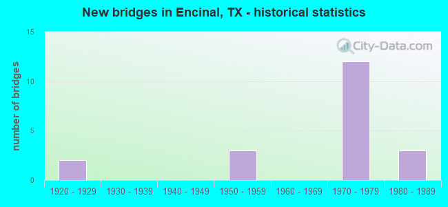
- New bridges - historical statistics
- 21920-1929
- 31950-1959
- 121970-1979
- 31980-1989

- Reconstructed bridges - Historical Statistics
- 11950-1959
- 01960-1969
- 11970-1979


- Bridge Condition - Deck
- 50.0%Good
- 50.0%Satisfactory

- Bridge Condition - Superstructure
- 70.0%Good
- 30.0%Satisfactory

- Bridge Condition - Substructure
- 70.0%Good
- 30.0%Satisfactory

- Bridge Condition - Channel
- 7.7%Very good
- 69.2%Good
- 23.1%Satisfactory

- Bridge Condition - Culverts
- 57.1%Good
- 42.9%Satisfactory
Find on map >> Show street view
Structure Number: 22142000170803, Location: 1.0 MI N OF FM 469 E (Lat: 28.591578, Lng: -99.193131), Route carried "on" structure: ServiceInterstate 35, Year Built: 1929, Status: Open, Structure Length: 3.02m (9.91ft), Average Daily Traffic: 600 (year 2013), Truck Traffic: 22%, Average Future Daily Traffic: 840 (year 2033), Design Load: H 15, Features Intersected: CIBOLO CREEK
Minimum Vertical Clearance: 30+ m (98+ ft), Kilometerpoint: 19.323, Lanes on structure: 2, Owner: State Highway Agency, Approaching Roadway Width: 6.1m (20.0ft), Material/Design: Concrete, Design/Construction: Tee Beam, Number Of Spans In Main Unit: 3, Length of Maximum Span: 10.1m (33.1ft), Curb-To-Curb Width: 6.9m (22.6ft), Out-to-Out Width: 8.2m (26.9ft)
Condition: Deck: Satisfactory, Superstructure: Good, Substructure: Satisfactory, Channel: Good, Operating Rating: 49.9 metric tons, Method Used To Determine Operating Rating: Load Factor (LF), Inventory Rating: 29.9 metric tons, Method Used To Determine Inventory Rating: Load Factor (LF), Structural Evaluation: Equal to present minimum criteria, Deck Geometry: Meets minimum limits, Waterway Adequacy: Better than present minimum criteria, Approach Roadway Alignment: Equal to present desirable criteria, Designated Inspection Frequency: Every 24 months, Inspection Date: June 2020, Deck Structure Type: Concrete Cast-file-Place, Wearing Surface/Protective System: Wearing Surface: Bituminous
Find on map >> Show street view
Structure Number: 221420001802138, Location: 4.25 MI N OF WEBB C/L (Lat: 28.090042, Lng: -99.339022), Route carried "on" structure: Interstate 35, Year Built: 1978, Status: Open, Structure Length: 1.55m (5.09ft), Average Daily Traffic: 17,311 (year 2020), Truck Traffic: 22%, Average Future Daily Traffic: 24,320 (year 2033), Design Load: HS 20, Features Intersected: DRAW
Minimum Vertical Clearance: 30+ m (98+ ft), Kilometerpoint: 39.506, Lanes on structure: 8, Base Highway Network: Yes, Owner: State Highway Agency, Approaching Roadway Width: 36.6m (120.1ft), Skew: 29 degrees, Material/Design: Concrete, Design/Construction: Culvert, Number Of Spans In Main Unit: 6, Length of Maximum Span: 2.4m (7.9ft), Curb-To-Curb Width: 36.6m (120.1ft), Out-to-Out Width: 90.6m (297.2ft)
Condition: Channel: Good, Culverts: Good, Operating Rating: 39.9 metric tons, Method Used To Determine Operating Rating: Load Factor (LF), Inventory Rating: 23.6 metric tons, Method Used To Determine Inventory Rating: Load Factor (LF), Structural Evaluation: Somewhat better than minimum adequacy, Deck Geometry: Better than present minimum criteria, Waterway Adequacy: Equal to present minimum criteria, Approach Roadway Alignment: Equal to present desirable criteria, Designated Inspection Frequency: Every 48 months, Inspection Date: August 2020, Deck Structure Type: Concrete Cast-file-Place, Wearing Surface/Protective System: Wearing Surface: Bituminous
Find on map >> Show street view
Structure Number: 221420001802139, Location: 1.55 MI N OF WEBB C/L (Lat: 28.052142, Lng: -99.350067), Route carried "on" structure: Interstate 35, Year Built: 1978, Status: Open, Structure Length: 0.88m (2.89ft), Average Daily Traffic: 17,311 (year 2020), Truck Traffic: 22%, Average Future Daily Traffic: 24,320 (year 2033), Design Load: HS 20, Features Intersected: DRAW
Minimum Vertical Clearance: 30+ m (98+ ft), Kilometerpoint: 35.151, Lanes on structure: 6, Base Highway Network: Yes, Owner: State Highway Agency, Approaching Roadway Width: 34.1m (111.9ft), Skew: 23 degrees, Material/Design: Concrete, Design/Construction: Culvert, Number Of Spans In Main Unit: 3, Length of Maximum Span: 2.4m (7.9ft), Curb-To-Curb Width: 34.1m (111.9ft), Out-to-Out Width: 72.0m (236.2ft)
Condition: Channel: Very good, Culverts: Good, Operating Rating: 39.9 metric tons, Method Used To Determine Operating Rating: Load Factor (LF), Inventory Rating: 23.6 metric tons, Method Used To Determine Inventory Rating: Load Factor (LF), Structural Evaluation: Somewhat better than minimum adequacy, Deck Geometry: Superior to present desirable criteria, Waterway Adequacy: Equal to present minimum criteria, Approach Roadway Alignment: Equal to present desirable criteria, Designated Inspection Frequency: Every 48 months, Inspection Date: August 2020, Deck Structure Type: Concrete Cast-file-Place, Wearing Surface/Protective System: Wearing Surface: Bituminous
Find on map >> Show street view
Structure Number: 22142000180214, Location: 1.10 MI N OF WEBB C/L (Lat: 28.046186, Lng: -99.350314), Route carried "on" structure: Interstate 35, Year Built: 1978, Status: Open, Structure Length: 5.33m (17.49ft), Average Daily Traffic: 10,162 (year 2019), Truck Traffic: 28%, Average Future Daily Traffic: 12,650 (year 2036), Design Load: HS 20, Features Intersected: SH 44
Minimum Vertical Clearance: 30+ m (98+ ft), Kilometerpoint: 34.482, Lanes on structure: 2, Lanes under structure: 2, Base Highway Network: Yes, Owner: State Highway Agency, Approaching Roadway Width: 11.6m (38.1ft), Material/Design: Prestressed concrete, Design/Construction: Stringer/Multi-beam, Number Of Spans In Main Unit: 1, Number Of Approach Spans: 2, Length of Maximum Span: 29.0m (95.1ft), Curb-To-Curb Width: 11.8m (38.7ft), Out-to-Out Width: 12.3m (40.4ft)
Condition: Deck: Good, Superstructure: Good, Substructure: Good, Operating Rating: 54.4 metric tons, Method Used To Determine Operating Rating: Assigned rating based on Load Factor Design (LFD) reported in metric tons, Inventory Rating: 32.7 metric tons, Method Used To Determine Inventory Rating: Assigned rating based on Load Factor Design (LFD) reported in metric tons, Structural Evaluation: Better than present minimum criteria, Deck Geometry: Equal to present minimum criteria, Underclear: Superior to present desirable criteria, Approach Roadway Alignment: Equal to present desirable criteria, Designated Inspection Frequency: Every 24 months, Inspection Date: July 2020, Deck Structure Type: Concrete Cast-file-Place, Wearing Surface/Protective System: Wearing Surface: Bituminous
Find on map >> Show street view
Structure Number: 221420001802141, Location: 1.10 MI N OF WEBB C/L (Lat: 28.046181, Lng: -99.350017), Route carried "on" structure: Interstate 35, Year Built: 1978, Status: Open, Structure Length: 5.33m (17.49ft), Average Daily Traffic: 10,446 (year 2019), Truck Traffic: 28%, Average Future Daily Traffic: 12,650 (year 2036), Design Load: HS 20, Features Intersected: SH 44
Minimum Vertical Clearance: 30+ m (98+ ft), Kilometerpoint: 34.482, Lanes on structure: 2, Lanes under structure: 2, Base Highway Network: Yes, Owner: State Highway Agency, Approaching Roadway Width: 11.6m (38.1ft), Material/Design: Prestressed concrete, Design/Construction: Stringer/Multi-beam, Number Of Spans In Main Unit: 1, Number Of Approach Spans: 2, Length of Maximum Span: 29.0m (95.1ft), Curb-To-Curb Width: 11.8m (38.7ft), Out-to-Out Width: 12.3m (40.4ft)
Condition: Deck: Good, Superstructure: Satisfactory, Substructure: Good, Operating Rating: 54.4 metric tons, Method Used To Determine Operating Rating: Assigned rating based on Load Factor Design (LFD) reported in metric tons, Inventory Rating: 32.7 metric tons, Method Used To Determine Inventory Rating: Assigned rating based on Load Factor Design (LFD) reported in metric tons, Structural Evaluation: Equal to present minimum criteria, Deck Geometry: Equal to present minimum criteria, Underclear: Better than present minimum criteria, Approach Roadway Alignment: Equal to present desirable criteria, Designated Inspection Frequency: Every 24 months, Inspection Date: July 2020, Deck Structure Type: Concrete Cast-file-Place, Wearing Surface/Protective System: Wearing Surface: Bituminous
Find on map >> Show street view
Structure Number: 222400001803018, Location: 3.10 MI S OF LASALLE C/L (Lat: 27.989164, Lng: -99.370967), Route carried "on" structure: ServiceInterstate 35, Year Built: 1922, Year Reconstructed: 1958, Status: Open, Structure Length: 1.83m (6.00ft), Average Daily Traffic: 600 (year 2018), Truck Traffic: 2%, Average Future Daily Traffic: 840 (year 2038), Features Intersected: JAMONCILLOS CREEK
Minimum Vertical Clearance: 30+ m (98+ ft), Kilometerpoint: 38.232, Lanes on structure: 2, Owner: State Highway Agency, Approaching Roadway Width: 11.0m (36.1ft), Material/Design: Concrete, Design/Construction: Slab, Number Of Spans In Main Unit: 3, Length of Maximum Span: 6.1m (20.0ft), Curb-To-Curb Width: 11.5m (37.7ft), Out-to-Out Width: 12.3m (40.4ft)
Condition: Deck: Satisfactory, Superstructure: Satisfactory, Substructure: Satisfactory, Channel: Satisfactory, Operating Rating: 42.6 metric tons, Method Used To Determine Operating Rating: Load Factor (LF), Inventory Rating: 25.4 metric tons, Method Used To Determine Inventory Rating: Load Factor (LF), Structural Evaluation: Equal to present minimum criteria, Deck Geometry: Better than present minimum criteria, Waterway Adequacy: Equal to present minimum criteria, Approach Roadway Alignment: Equal to present desirable criteria, Designated Inspection Frequency: Every 24 months, Inspection Date: December 2020, Deck Structure Type: Concrete Cast-file-Place, Wearing Surface/Protective System: Wearing Surface: Bituminous
Find on map >> Show street view
Structure Number: 222400001803045, Location: 0.45 MI S OF LASALLE C/L (Lat: 28.025442, Lng: -99.359297), Route carried "on" structure: Interstate 35, Year Built: 1958, Status: Open, Structure Length: 3.35m (10.99ft), Average Daily Traffic: 10,282 (year 2019), Truck Traffic: 21%, Average Future Daily Traffic: 13,780 (year 2038), Features Intersected: JABONCILLO CREEK
Minimum Vertical Clearance: 30+ m (98+ ft), Kilometerpoint: 42.474, Lanes on structure: 2, Base Highway Network: Yes, Owner: State Highway Agency, Approaching Roadway Width: 11.6m (38.1ft), Material/Design: Concrete continuous, Design/Construction: Slab, Number Of Spans In Main Unit: 4, Length of Maximum Span: 9.1m (29.9ft), Curb-To-Curb Width: 11.8m (38.7ft), Out-to-Out Width: 12.3m (40.4ft)
Condition: Deck: Good, Superstructure: Good, Substructure: Good, Channel: Good, Operating Rating: 44.4 metric tons, Method Used To Determine Operating Rating: Load Factor (LF), Inventory Rating: 28.1 metric tons, Method Used To Determine Inventory Rating: Load Factor (LF), Structural Evaluation: Better than present minimum criteria, Deck Geometry: Equal to present minimum criteria, Waterway Adequacy: Superior to present desirable criteria, Approach Roadway Alignment: Equal to present desirable criteria, Designated Inspection Frequency: Every 24 months, Inspection Date: December 2020, Deck Structure Type: Concrete Cast-file-Place, Wearing Surface/Protective System: Wearing Surface: Bituminous
Find on map >> Show street view
Structure Number: 222400001803047, Location: 2.15 MI S OF LASALLE C/L (Lat: 28.001889, Lng: -99.366300), Route carried "on" structure: Interstate 35, Year Built: 1958, Year Reconstructed: 1983, Status: Open, Structure Length: 1.31m (4.30ft), Average Daily Traffic: 17,297 (year 2020), Truck Traffic: 21%, Average Future Daily Traffic: 27,570 (year 2038), Features Intersected: DRAW
Minimum Vertical Clearance: 30+ m (98+ ft), Kilometerpoint: 39.770, Lanes on structure: 8, Base Highway Network: Yes, Owner: State Highway Agency, Approaching Roadway Width: 39.8m (130.6ft), Skew: 20 degrees, Material/Design: Concrete, Design/Construction: Culvert, Number Of Spans In Main Unit: 4, Length of Maximum Span: 3.0m (9.8ft), Curb-To-Curb Width: 42.1m (138.1ft), Out-to-Out Width: 77.7m (254.9ft)
Condition: Channel: Good, Culverts: Satisfactory, Operating Rating: 39.9 metric tons, Method Used To Determine Operating Rating: Load Factor (LF), Inventory Rating: 23.6 metric tons, Method Used To Determine Inventory Rating: Load Factor (LF), Structural Evaluation: Somewhat better than minimum adequacy, Deck Geometry: Superior to present desirable criteria, Waterway Adequacy: Equal to present minimum criteria, Approach Roadway Alignment: Equal to present desirable criteria, Designated Inspection Frequency: Every 24 months, Inspection Date: December 2020, Deck Structure Type: Concrete Cast-file-Place, Wearing Surface/Protective System: Wearing Surface: Bituminous
Find on map >> Show street view
Structure Number: 222400001803048, Location: 3.10 MI S OF LASALLE C/L (Lat: 27.988431, Lng: -99.370675), Route carried "on" structure: Interstate 35, Year Built: 1958, Status: Open, Structure Length: 5.70m (18.70ft), Average Daily Traffic: 10,282 (year 2019), Truck Traffic: 21%, Average Future Daily Traffic: 13,780 (year 2038), Features Intersected: JAMONCILLOS CREEK
Minimum Vertical Clearance: 30+ m (98+ ft), Kilometerpoint: 38.232, Lanes on structure: 2, Base Highway Network: Yes, Owner: State Highway Agency, Approaching Roadway Width: 11.5m (37.7ft), Skew: 3 degrees, Material/Design: Concrete, Design/Construction: Culvert, Number Of Spans In Main Unit: 15, Length of Maximum Span: 3.0m (9.8ft), Curb-To-Curb Width: 11.5m (37.7ft), Out-to-Out Width: 12.2m (40.0ft)
Condition: Channel: Good, Culverts: Satisfactory, Operating Rating: 39.9 metric tons, Method Used To Determine Operating Rating: Load Factor (LF), Inventory Rating: 23.6 metric tons, Method Used To Determine Inventory Rating: Load Factor (LF), Structural Evaluation: Somewhat better than minimum adequacy, Deck Geometry: Somewhat better than minimum adequacy, Waterway Adequacy: Equal to present minimum criteria, Approach Roadway Alignment: Equal to present desirable criteria, Designated Inspection Frequency: Every 24 months, Inspection Date: December 2020, Deck Structure Type: Concrete Cast-file-Place, Wearing Surface/Protective System: Wearing Surface: Bituminous
Find on map >> Show street view
Structure Number: 222400001803142, Location: 0.10 MI S OF LASALLE C/L (Lat: 28.030008, Lng: -99.357703), Route carried "on" structure: Interstate 35, Year Built: 1978, Status: Open, Structure Length: 3.96m (12.99ft), Average Daily Traffic: 10,310 (year 2019), Truck Traffic: 21%, Average Future Daily Traffic: 13,780 (year 2038), Design Load: HS 20, Features Intersected: IH 35 BUS
Minimum Vertical Clearance: 30+ m (98+ ft), Kilometerpoint: 42.969, Lanes on structure: 2, Lanes under structure: 2, Base Highway Network: Yes, Owner: State Highway Agency, Approaching Roadway Width: 11.6m (38.1ft), Material/Design: Prestressed concrete, Design/Construction: Stringer/Multi-beam, Number Of Spans In Main Unit: 1, Number Of Approach Spans: 2, Length of Maximum Span: 18.3m (60.0ft), Curb-To-Curb Width: 11.8m (38.7ft), Out-to-Out Width: 12.3m (40.4ft)
Condition: Deck: Satisfactory, Superstructure: Good, Substructure: Good, Operating Rating: 54.4 metric tons, Method Used To Determine Operating Rating: Assigned rating based on Load Factor Design (LFD) reported in metric tons, Inventory Rating: 32.7 metric tons, Method Used To Determine Inventory Rating: Assigned rating based on Load Factor Design (LFD) reported in metric tons, Structural Evaluation: Better than present minimum criteria, Deck Geometry: Equal to present minimum criteria, Underclear: Superior to present desirable criteria, Approach Roadway Alignment: Equal to present desirable criteria, Designated Inspection Frequency: Every 24 months, Inspection Date: December 2020, Deck Structure Type: Concrete Cast-file-Place
Find on map >> Show street view
Structure Number: 222400001803143, Location: 0.10 MI S OF LASALLE C/L (Lat: 28.029633, Lng: -99.357606), Route carried "on" structure: Interstate 35, Year Built: 1978, Status: Open, Structure Length: 3.96m (12.99ft), Average Daily Traffic: 10,282 (year 2019), Truck Traffic: 21%, Average Future Daily Traffic: 13,780 (year 2038), Design Load: HS 20, Features Intersected: IH 35 BUS
Minimum Vertical Clearance: 30+ m (98+ ft), Kilometerpoint: 42.969, Lanes on structure: 2, Lanes under structure: 2, Base Highway Network: Yes, Owner: State Highway Agency, Approaching Roadway Width: 11.6m (38.1ft), Material/Design: Prestressed concrete, Design/Construction: Stringer/Multi-beam, Number Of Spans In Main Unit: 1, Number Of Approach Spans: 2, Length of Maximum Span: 18.3m (60.0ft), Curb-To-Curb Width: 11.8m (38.7ft), Out-to-Out Width: 12.3m (40.4ft)
Condition: Deck: Good, Superstructure: Good, Substructure: Good, Operating Rating: 54.4 metric tons, Method Used To Determine Operating Rating: Assigned rating based on Load Factor Design (LFD) reported in metric tons, Inventory Rating: 32.7 metric tons, Method Used To Determine Inventory Rating: Assigned rating based on Load Factor Design (LFD) reported in metric tons, Structural Evaluation: Better than present minimum criteria, Deck Geometry: Equal to present minimum criteria, Underclear: Superior to present desirable criteria, Approach Roadway Alignment: Equal to present desirable criteria, Designated Inspection Frequency: Every 24 months, Inspection Date: December 2020, Deck Structure Type: Concrete Cast-file-Place
Find on map >> Show street view
Structure Number: 222400001803144, Location: 0.45 MI S OF LASALLE C/L (Lat: 28.025850, Lng: -99.359703), Route carried "on" structure: ServiceInterstate 35, Year Built: 1978, Status: Open, Structure Length: 2.93m (9.61ft), Average Daily Traffic: 600 (year 2013), Truck Traffic: 2%, Average Future Daily Traffic: 840 (year 2033), Design Load: HS 20, Features Intersected: JABONCILLO CREEK
Minimum Vertical Clearance: 30+ m (98+ ft), Kilometerpoint: 42.483, Lanes on structure: 2, Owner: State Highway Agency, Approaching Roadway Width: 7.6m (24.9ft), Material/Design: Concrete, Design/Construction: Culvert, Number Of Spans In Main Unit: 11, Length of Maximum Span: 2.4m (7.9ft), Curb-To-Curb Width: 7.8m (25.6ft), Out-to-Out Width: 8.5m (27.9ft)
Condition: Channel: Good, Culverts: Good, Operating Rating: 39.9 metric tons, Method Used To Determine Operating Rating: Load Factor (LF), Inventory Rating: 23.6 metric tons, Method Used To Determine Inventory Rating: Load Factor (LF), Structural Evaluation: Equal to present minimum criteria, Deck Geometry: Meets minimum limits, Waterway Adequacy: Equal to present minimum criteria, Approach Roadway Alignment: Equal to present desirable criteria, Designated Inspection Frequency: Every 48 months, Inspection Date: December 2020, Deck Structure Type: Concrete Cast-file-Place, Wearing Surface/Protective System: Wearing Surface: Bituminous
Find on map >> Show street view
Structure Number: 222400001803145, Location: 0.45 MI S OF LASALLE C/L (Lat: 28.025797, Lng: -99.359492), Route carried "on" structure: Interstate 35, Year Built: 1978, Status: Open, Structure Length: 3.66m (12.01ft), Average Daily Traffic: 10,310 (year 2019), Truck Traffic: 21%, Average Future Daily Traffic: 13,780 (year 2038), Design Load: HS 20, Features Intersected: JABONCILLO CREEK
Minimum Vertical Clearance: 30+ m (98+ ft), Kilometerpoint: 42.475, Lanes on structure: 2, Base Highway Network: Yes, Owner: State Highway Agency, Approaching Roadway Width: 11.6m (38.1ft), Skew: 1 degrees, Material/Design: Concrete, Design/Construction: Slab, Number Of Spans In Main Unit: 6, Length of Maximum Span: 6.1m (20.0ft), Curb-To-Curb Width: 11.8m (38.7ft), Out-to-Out Width: 12.3m (40.4ft)
Condition: Deck: Satisfactory, Superstructure: Satisfactory, Substructure: Satisfactory, Channel: Good, Operating Rating: 54.4 metric tons, Method Used To Determine Operating Rating: Assigned rating based on Load Factor Design (LFD) reported in metric tons, Inventory Rating: 32.7 metric tons, Method Used To Determine Inventory Rating: Assigned rating based on Load Factor Design (LFD) reported in metric tons, Structural Evaluation: Equal to present minimum criteria, Deck Geometry: Equal to present minimum criteria, Waterway Adequacy: Superior to present desirable criteria, Approach Roadway Alignment: Equal to present desirable criteria, Designated Inspection Frequency: Every 24 months, Inspection Date: December 2020, Deck Structure Type: Concrete Cast-file-Place
Find on map >> Show street view
Structure Number: 222400001803146, Location: 0.45 MI S OF LASALLE C/L (Lat: 28.025381, Lng: -99.359058), Route carried "on" structure: ServiceInterstate 35, Year Built: 1978, Status: Open, Structure Length: 2.77m (9.09ft), Average Daily Traffic: 390 (year 2013), Truck Traffic: 22%, Average Future Daily Traffic: 550 (year 2033), Design Load: HS 20, Features Intersected: JABONCILLO CREEK
Minimum Vertical Clearance: 30+ m (98+ ft), Kilometerpoint: 42.474, Lanes on structure: 2, Owner: State Highway Agency, Approaching Roadway Width: 5.8m (19.0ft), Material/Design: Concrete, Design/Construction: Culvert, Number Of Spans In Main Unit: 12, Length of Maximum Span: 2.1m (6.9ft), Curb-To-Curb Width: 7.3m (24.0ft), Out-to-Out Width: 8.9m (29.2ft)
Condition: Channel: Satisfactory, Culverts: Good, Operating Rating: 39.9 metric tons, Method Used To Determine Operating Rating: Load Factor (LF), Inventory Rating: 23.6 metric tons, Method Used To Determine Inventory Rating: Load Factor (LF), Structural Evaluation: Equal to present minimum criteria, Deck Geometry: Somewhat better than minimum adequacy, Waterway Adequacy: Equal to present minimum criteria, Approach Roadway Alignment: Equal to present desirable criteria, Designated Inspection Frequency: Every 48 months, Inspection Date: December 2020, Deck Structure Type: Concrete Cast-file-Place, Wearing Surface/Protective System: Wearing Surface: Bituminous
Find on map >> Show street view
Structure Number: 222400001803157, Location: 3.10 MI S OF LASALLE C/L (Lat: 27.988350, Lng: -99.370483), Route carried "on" structure: ServiceInterstate 35, Year Built: 1983, Status: Open, Structure Length: 4.57m (14.99ft), Average Daily Traffic: 390 (year 2018), Truck Traffic: 22%, Average Future Daily Traffic: 550 (year 2038), Design Load: HS 20, Features Intersected: JAMONCILLOS CREEK
Minimum Vertical Clearance: 30+ m (98+ ft), Kilometerpoint: 38.217, Lanes on structure: 2, Owner: State Highway Agency, Approaching Roadway Width: 6.7m (22.0ft), Skew: 3 degrees, Material/Design: Concrete continuous, Design/Construction: Slab, Number Of Spans In Main Unit: 6, Length of Maximum Span: 7.6m (24.9ft), Curb-To-Curb Width: 8.6m (28.2ft), Out-to-Out Width: 9.1m (29.9ft)
Condition: Deck: Good, Superstructure: Good, Substructure: Good, Channel: Good, Operating Rating: 54.4 metric tons, Method Used To Determine Operating Rating: Assigned rating based on Load Factor Design (LFD) reported in metric tons, Inventory Rating: 32.7 metric tons, Method Used To Determine Inventory Rating: Assigned rating based on Load Factor Design (LFD) reported in metric tons, Structural Evaluation: Better than present minimum criteria, Deck Geometry: Equal to present minimum criteria, Waterway Adequacy: Equal to present minimum criteria, Approach Roadway Alignment: Equal to present desirable criteria, Designated Inspection Frequency: Every 24 months, Inspection Date: December 2020, Deck Structure Type: Concrete Cast-file-Place, Wearing Surface/Protective System: Wearing Surface: Bituminous
Find on map >> Show street view
Structure Number: 222400001803158, Location: 3.10 MI S OF LASALLE C/L (Lat: 27.989078, Lng: -99.370769), Route carried "on" structure: Interstate 35, Year Built: 1983, Status: Open, Structure Length: 6.40m (21.00ft), Average Daily Traffic: 10,310 (year 2019), Truck Traffic: 21%, Average Future Daily Traffic: 13,780 (year 2038), Design Load: HS 20, Features Intersected: JAMONCILLOS CREEK
Minimum Vertical Clearance: 30+ m (98+ ft), Kilometerpoint: 38.232, Lanes on structure: 2, Base Highway Network: Yes, Owner: State Highway Agency, Approaching Roadway Width: 11.6m (38.1ft), Skew: 3 degrees, Material/Design: Concrete continuous, Design/Construction: Slab, Number Of Spans In Main Unit: 8, Length of Maximum Span: 9.1m (29.9ft), Curb-To-Curb Width: 11.5m (37.7ft), Out-to-Out Width: 12.2m (40.0ft)
Condition: Deck: Satisfactory, Superstructure: Good, Substructure: Good, Channel: Good, Operating Rating: 54.4 metric tons, Method Used To Determine Operating Rating: Assigned rating based on Load Factor Design (LFD) reported in metric tons, Inventory Rating: 32.7 metric tons, Method Used To Determine Inventory Rating: Assigned rating based on Load Factor Design (LFD) reported in metric tons, Structural Evaluation: Better than present minimum criteria, Deck Geometry: Somewhat better than minimum adequacy, Waterway Adequacy: Equal to present minimum criteria, Approach Roadway Alignment: Equal to present desirable criteria, Designated Inspection Frequency: Every 24 months, Inspection Date: December 2020, Deck Structure Type: Concrete Cast-file-Place
Find on map >> Show street view
Structure Number: 222400AA1026001, Location: 1.50 MI E OF IH 35 (Lat: 28.024222, Lng: -99.338494), Route carried "on" structure: County highway 1026, Year Built: 1987, Status: Open, Structure Length: 1.19m (3.90ft), Average Daily Traffic: 478 (year 2018), Average Future Daily Traffic: 60 (year 2038), Design Load: HS 20, Features Intersected: JABONCILLO CREEK BRANCH, Facility Carried by Structure: MARTINENA RD
Minimum Vertical Clearance: 30+ m (98+ ft), Kilometerpoint: 0.000, Lanes on structure: 2, Owner: County Highway Agency, Approaching Roadway Width: 4.9m (16.1ft), Material/Design: Concrete, Design/Construction: Culvert, Number Of Spans In Main Unit: 4, Length of Maximum Span: 2.7m (8.9ft), Curb-To-Curb Width: 7.2m (23.6ft), Out-to-Out Width: 7.9m (25.9ft)
Condition: Channel: Satisfactory, Culverts: Satisfactory, Operating Rating: 39.9 metric tons, Method Used To Determine Operating Rating: Load Factor (LF), Inventory Rating: 23.6 metric tons, Method Used To Determine Inventory Rating: Load Factor (LF), Structural Evaluation: Equal to present minimum criteria, Deck Geometry: Meets minimum limits, Waterway Adequacy: Better than present minimum criteria, Approach Roadway Alignment: Equal to present desirable criteria, Designated Inspection Frequency: Every 24 months, Inspection Date: August 2020, Deck Structure Type: Concrete Cast-file-Place, Wearing Surface/Protective System: Wearing Surface: Bituminous
Find on map >> Show street view
Structure Number: 22142000180214, Location: 1.10 MI N OF WEBB C/L (Lat: 28.046144, Lng: -99.350603), Route carried "under" structure: State highway 44, Year Built: 1978, Structure Length: 0. m, Average Daily Traffic: 3,687 (year 2016), Truck Traffic: 9%, Features Intersected: SH 44, Facility Carried by Structure: IH 35 SB
Minimum Vertical Clearance: 5.56m (18.24ft), Kilometerpoint: 0.290, Lanes on structure: 2, Lanes under structure: 2, Material/Design: Prestressed concrete, Design/Construction: Stringer/Multi-beam, Length of Maximum Span: 29.0m (95.1ft)
Find on map >> Show street view
Structure Number: 221420001802141, Location: 1.10 MI N OF WEBB C/L (Lat: 28.046144, Lng: -99.350603), Route carried "under" structure: State highway 44, Year Built: 1978, Structure Length: 0. m, Average Daily Traffic: 3,687 (year 2016), Truck Traffic: 9%, Features Intersected: SH 44, Facility Carried by Structure: IH 35 NB
Minimum Vertical Clearance: 4.98m (16.34ft), Kilometerpoint: 0.338, Lanes on structure: 2, Lanes under structure: 2, Material/Design: Prestressed concrete, Design/Construction: Stringer/Multi-beam, Length of Maximum Span: 29.0m (95.1ft)
Find on map >> Show street view
Structure Number: 222400001803142, Location: 0.10 MI S OF LASALLE C/L (Lat: 28.030008, Lng: -99.357703), Route carried "under" structure: Business State highway 35, Year Built: 1978, Structure Length: 0. m, Average Daily Traffic: 930 (year 2018), Truck Traffic: 1%, Features Intersected: IH 35 BUS
Minimum Vertical Clearance: 5.11m (16.77ft), Kilometerpoint: 1.049, Lanes on structure: 2, Lanes under structure: 2, Material/Design: Prestressed concrete, Design/Construction: Stringer/Multi-beam, Length of Maximum Span: 18.3m (60.0ft)