Bridge Statistics for Emmitsburg, Maryland (MD)
Condition, Traffic, Stress, Structural Evaluation, Project Costs
- National Bridge Inventory (NBI) Statistics
- 22Number of bridges
- 213ft / 65.4mTotal length
- $463,000Total costs
- 130,431Total average daily traffic
- 9,116Total average daily truck traffic
- National Bridge Inventory (NBI) Registered Bridges for Emmitsburg
- No street view available for this location
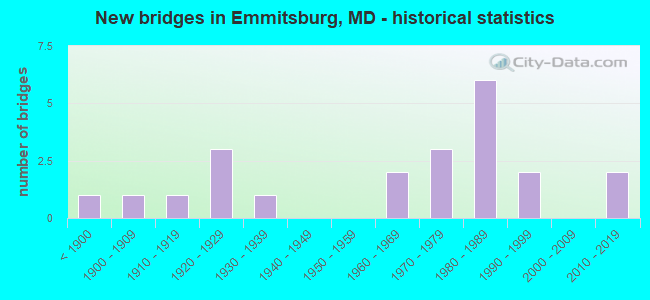
- New bridges - historical statistics
- 1Before 1900
- 11900-1909
- 11910-1919
- 31920-1929
- 11930-1939
- 21960-1969
- 31970-1979
- 61980-1989
- 21990-1999
- 22010-2019

- Reconstructed bridges - Historical Statistics
- 21970-1979
- 11980-1989
- 41990-1999


- Bridge Condition - Deck
- 11.1%Very good
- 16.7%Good
- 61.1%Satisfactory
- 11.1%Fair

- Bridge Condition - Superstructure
- 11.1%Excellent
- 27.8%Good
- 44.4%Satisfactory
- 11.1%Fair
- 5.6%Serious

- Bridge Condition - Substructure
- 5.6%Excellent
- 5.6%Very good
- 44.4%Good
- 33.3%Satisfactory
- 11.1%Fair

- Bridge Condition - Channel
- 20.0%Very good
- 50.0%Good
- 30.0%Satisfactory

- Bridge Condition - Culverts
- 33.3%Very good
- 33.3%Good
- 33.3%Satisfactory
Find on map >> Show street view
Structure Number: 10000010000101, Location: 0.75 MILE SOUTH OF US 15 (Lat: 39.708456, Lng: -77.321703), Route carried "on" structure: Business US 15, Year Built: 1927, Status: Open, Structure Length: 1.52m (4.99ft), Average Daily Traffic: 1,820 (year 2009), Truck Traffic: 8%, Average Future Daily Traffic: 2,260 (year 2026), Features Intersected: FLAT RUN
Minimum Vertical Clearance: 30+ m (98+ ft), Kilometerpoint: 1.207, Lanes on structure: 2, Owner: State Highway Agency, Approaching Roadway Width: 8.5m (27.9ft), Material/Design: Concrete, Design/Construction: Arch - Deck, Number Of Spans In Main Unit: 1, Length of Maximum Span: 15.2m (49.9ft), Curb-To-Curb Width: 7.3m (24.0ft), Out-to-Out Width: 8.3m (27.2ft)
Condition: Deck: Fair, Superstructure: Fair, Substructure: Fair, Channel: Good, Inventory Rating: 81.6 metric tons, Method Used To Determine Inventory Rating: Load Factor (LF), Structural Evaluation: Somewhat better than minimum adequacy, Deck Geometry: Meets minimum limits, Waterway Adequacy: Equal to present desirable criteria, Approach Roadway Alignment: Equal to present desirable criteria, Length Of Structure Improvement: 1.59m (5.22ft), Designated Inspection Frequency: Every 24 months, Inspection Date: November 2020, Bridge Improvement Cost: $85,000, Roadway Improvement Cost: $8,000, Total Project Cost: $94,000, Deck Structure Type: Concrete Cast-file-Place, Wearing Surface/Protective System: Wearing Surface: Bituminous
Find on map >> Show street view
Structure Number: 10000010000201, Location: 0.23 MILE NORTH OF US 15 (Lat: 39.691392, Lng: -77.332469), Route carried "on" structure: Business US 15, Year Built: 1923, Status: Open, Structure Length: 2.44m (8.01ft), Average Daily Traffic: 7,680 (year 2009), Truck Traffic: 8%, Average Future Daily Traffic: 9,743 (year 2026), Features Intersected: TOMS CREEK
Minimum Vertical Clearance: 30+ m (98+ ft), Kilometerpoint: 3.395, Lanes on structure: 2, Owner: State Highway Agency, Approaching Roadway Width: 9.4m (30.8ft), Material/Design: Concrete, Design/Construction: Arch - Deck, Number Of Spans In Main Unit: 1, Length of Maximum Span: 24.4m (80.1ft), Curb-To-Curb Width: 7.3m (24.0ft), Out-to-Out Width: 8.3m (27.2ft)
Condition: Deck: Satisfactory, Superstructure: Satisfactory, Substructure: Satisfactory, Channel: Good, Structural Evaluation: Equal to present minimum criteria, Deck Geometry: High priority of replacement, Waterway Adequacy: Better than present minimum criteria, Approach Roadway Alignment: Equal to present desirable criteria, Length Of Structure Improvement: 2.53m (8.30ft), Designated Inspection Frequency: Every 24 months, Inspection Date: November 2020, Bridge Improvement Cost: $136,000, Roadway Improvement Cost: $14,000, Total Project Cost: $150,000, Deck Structure Type: Concrete Cast-file-Place, Wearing Surface/Protective System: Wearing Surface: Bituminous
Find on map >> Show street view
Structure Number: 10000010006201, Location: 0.4 MI E OF EMMITSBURG (Lat: 39.702919, Lng: -77.319225), Route carried "on" structure: State highway 140, Year Built: 2019, Status: Open, Structure Length: 2.63m (8.63ft), Average Daily Traffic: 9,011 (year 2016), Truck Traffic: 11%, Average Future Daily Traffic: 12,200 (year 2031), Features Intersected: FLAT RUN
Minimum Vertical Clearance: 30+ m (98+ ft), Kilometerpoint: 7.868, Lanes on structure: 2, Base Highway Network: Yes, Owner: State Highway Agency, Approaching Roadway Width: 10.4m (34.1ft), Skew: 1 degrees, Material/Design: Prestressed concrete, Design/Construction: Stringer/Multi-beam, Number Of Spans In Main Unit: 1, Length of Maximum Span: 24.4m (80.1ft), Curb or Sidewalk Widths: Left: 1.7m (5.6ft), Right: 1.7m (5.6ft), Curb-To-Curb Width: 10.4m (34.1ft), Out-to-Out Width: 14.8m (48.6ft)
Condition: Deck: Very good, Superstructure: Excellent, Substructure: Excellent, Channel: Very good, Operating Rating: 61.6 metric tons, Method Used To Determine Operating Rating: Load and Resistance Factor Rating (LRFR) rating reported by rating factor(RF) method using HL-93 loadings, Inventory Rating: 47.0 metric tons, Method Used To Determine Inventory Rating: Load and Resistance Factor Rating (LRFR) rating reported by rating factor(RF) method using HL-93 loadings, Structural Evaluation: Superior to present desirable criteria, Deck Geometry: Meets minimum limits, Waterway Adequacy: Superior to present desirable criteria, Approach Roadway Alignment: Equal to present desirable criteria, Designated Inspection Frequency: Every 24 months, Inspection Date: March 2020, Deck Structure Type: Concrete Cast-file-Place, Wearing Surface/Protective System: Wearing Surface: Integral Concrete
Find on map >> Show street view
Structure Number: 10000010006301, Location: 0.72 MI S OF MD 904G (Lat: 39.699625, Lng: -77.296689), Route carried "on" structure: State highway 140, Year Built: 1932, Status: Open, Structure Length: 2.32m (7.61ft), Average Daily Traffic: 4,480 (year 2009), Truck Traffic: 8%, Average Future Daily Traffic: 5,340 (year 2026), Features Intersected: MIDDLE CREEK
Minimum Vertical Clearance: 30+ m (98+ ft), Kilometerpoint: 5.857, Lanes on structure: 2, Base Highway Network: Yes, Owner: State Highway Agency, Approaching Roadway Width: 9.8m (32.2ft), Material/Design: Concrete, Design/Construction: Tee Beam, Number Of Spans In Main Unit: 2, Length of Maximum Span: 10.7m (35.1ft), Curb-To-Curb Width: 12.2m (40.0ft), Out-to-Out Width: 13.3m (43.6ft)
Condition: Deck: Fair, Superstructure: Fair, Substructure: Fair, Channel: Satisfactory, Operating Rating: 73.9 metric tons, Method Used To Determine Operating Rating: Load Factor (LF), Inventory Rating: 44.4 metric tons, Method Used To Determine Inventory Rating: Load Factor (LF), Structural Evaluation: Somewhat better than minimum adequacy, Deck Geometry: Equal to present minimum criteria, Waterway Adequacy: Equal to present minimum criteria, Approach Roadway Alignment: Equal to present desirable criteria, Length Of Structure Improvement: 2.32m (7.61ft), Designated Inspection Frequency: Every 24 months, Inspection Date: November 2020, Bridge Improvement Cost: $199,000, Roadway Improvement Cost: $20,000, Total Project Cost: $219,000, Deck Structure Type: Concrete Cast-file-Place, Wearing Surface/Protective System: Wearing Surface: Bituminous
Find on map >> Show street view
Structure Number: 10000010012401, Location: 0.65 MILE N OF US 15BU (Lat: 39.691761, Lng: -77.322944), Route carried "on" structure: US 15, Year Built: 1965, Status: Open, Structure Length: 3.23m (10.60ft), Average Daily Traffic: 18,340 (year 2009), Truck Traffic: 8%, Average Future Daily Traffic: 28,040 (year 2029), Design Load: HS 20, Features Intersected: TOMS CREEK
Minimum Vertical Clearance: 30+ m (98+ ft), Kilometerpoint: 57.393, Lanes on structure: 2, Base Highway Network: Yes, Owner: State Highway Agency, Approaching Roadway Width: 13.4m (44.0ft), Skew: 2 degrees, Material/Design: Concrete continuous, Design/Construction: Slab, Number Of Spans In Main Unit: 3, Length of Maximum Span: 12.2m (40.0ft), Curb-To-Curb Width: 12.2m (40.0ft), Out-to-Out Width: 12.8m (42.0ft)
Condition: Deck: Satisfactory, Superstructure: Satisfactory, Substructure: Satisfactory, Channel: Satisfactory, Operating Rating: 54.4 metric tons, Method Used To Determine Operating Rating: Load Factor (LF), Inventory Rating: 32.7 metric tons, Method Used To Determine Inventory Rating: Load Factor (LF), Structural Evaluation: Equal to present minimum criteria, Deck Geometry: Better than present minimum criteria, Waterway Adequacy: Superior to present desirable criteria, Approach Roadway Alignment: Equal to present desirable criteria, Designated Inspection Frequency: Every 24 months, Inspection Date: November 2020, Deck Structure Type: Concrete Cast-file-Place, Wearing Surface/Protective System: Wearing Surface: Bituminous
Find on map >> Show street view
Structure Number: 10000010012501, Location: 0.2 MILE SOUTH OF MD 140 (Lat: 39.700172, Lng: -77.315169), Route carried "on" structure: US 15, Year Built: 1965, Year Reconstructed: 1981, Status: Open, Structure Length: 3.20m (10.50ft), Average Daily Traffic: 18,340 (year 2009), Truck Traffic: 8%, Average Future Daily Traffic: 11,057 (year 2026), Design Load: HS 20, Features Intersected: FLAT RUN
Minimum Vertical Clearance: 30+ m (98+ ft), Kilometerpoint: 58.568, Lanes on structure: 2, Base Highway Network: Yes, Owner: State Highway Agency, Approaching Roadway Width: 13.4m (44.0ft), Material/Design: Steel, Design/Construction: Stringer/Multi-beam, Number Of Spans In Main Unit: 1, Number Of Approach Spans: 1, Length of Maximum Span: 15.9m (52.2ft), Curb-To-Curb Width: 17.1m (56.1ft), Out-to-Out Width: 18.0m (59.1ft)
Condition: Deck: Satisfactory, Superstructure: Good, Substructure: Good, Channel: Satisfactory, Operating Rating: 66.7 metric tons, Method Used To Determine Operating Rating: Load Factor (LF), Inventory Rating: 39.9 metric tons, Method Used To Determine Inventory Rating: Load Factor (LF), Structural Evaluation: Better than present minimum criteria, Deck Geometry: Superior to present desirable criteria, Waterway Adequacy: Superior to present desirable criteria, Approach Roadway Alignment: Equal to present desirable criteria, Designated Inspection Frequency: Every 24 months, Inspection Date: July 2021, Deck Structure Type: Concrete Cast-file-Place, Wearing Surface/Protective System: Wearing Surface: Monolithic Concrete
Find on map >> Show street view
Structure Number: 10000010015301, Location: 0.16 MI S OF MD 904F (Lat: 39.702700, Lng: -77.313697), Route carried "on" structure: State highway 140, Year Built: 1971, Year Reconstructed: 1979, Status: Open, Structure Length: 7.71m (25.30ft), Average Daily Traffic: 9,010 (year 2018), Truck Traffic: 8%, Average Future Daily Traffic: 9,048 (year 2038), Design Load: HS 20, Features Intersected: US 15
Minimum Vertical Clearance: 30+ m (98+ ft), Kilometerpoint: 7.417, Lanes on structure: 2, Lanes under structure: 6, Base Highway Network: Yes, Owner: State Highway Agency, Approaching Roadway Width: 13.4m (44.0ft), Material/Design: Steel continuous, Design/Construction: Stringer/Multi-beam, Number Of Spans In Main Unit: 2, Number Of Approach Spans: 2, Length of Maximum Span: 28.0m (91.9ft), Curb-To-Curb Width: 13.4m (44.0ft), Out-to-Out Width: 14.4m (47.2ft)
Condition: Deck: Satisfactory, Superstructure: Satisfactory, Substructure: Good, Operating Rating: 82.1 metric tons, Method Used To Determine Operating Rating: Load Factor (LF), Inventory Rating: 49.4 metric tons, Method Used To Determine Inventory Rating: Load Factor (LF), Structural Evaluation: Equal to present minimum criteria, Deck Geometry: Equal to present minimum criteria, Underclear: Better than present minimum criteria, Approach Roadway Alignment: Equal to present desirable criteria, Designated Inspection Frequency: Every 24 months, Inspection Date: September 2021, Deck Structure Type: Concrete Cast-file-Place, Wearing Surface/Protective System: Wearing Surface: Monolithic Concrete
Find on map >> Show street view
Structure Number: 10000010016501, Location: 0.65 MILE N OF US 15BU (Lat: 39.691483, Lng: -77.322903), Route carried "on" structure: US 15, Year Built: 1980, Status: Open, Structure Length: 3.35m (10.99ft), Average Daily Traffic: 18,340 (year 2009), Truck Traffic: 8%, Average Future Daily Traffic: 28,040 (year 2029), Design Load: HS 20, Features Intersected: TOMS CREEK
Minimum Vertical Clearance: 30+ m (98+ ft), Kilometerpoint: 57.393, Lanes on structure: 2, Base Highway Network: Yes, Owner: State Highway Agency, Approaching Roadway Width: 11.6m (38.1ft), Skew: 2 degrees, Material/Design: Concrete continuous, Design/Construction: Slab, Number Of Spans In Main Unit: 3, Length of Maximum Span: 12.2m (40.0ft), Curb-To-Curb Width: 12.2m (40.0ft), Out-to-Out Width: 13.2m (43.3ft)
Condition: Deck: Satisfactory, Superstructure: Satisfactory, Substructure: Good, Channel: Good, Operating Rating: 88.0 metric tons, Method Used To Determine Operating Rating: Load Factor (LF), Inventory Rating: 52.6 metric tons, Method Used To Determine Inventory Rating: Load Factor (LF), Structural Evaluation: Equal to present minimum criteria, Deck Geometry: Better than present minimum criteria, Waterway Adequacy: Equal to present desirable criteria, Approach Roadway Alignment: Equal to present desirable criteria, Designated Inspection Frequency: Every 24 months, Inspection Date: November 2020, Deck Structure Type: Concrete Cast-file-Place, Wearing Surface/Protective System: Wearing Surface: Monolithic Concrete
Find on map >> Show street view
Structure Number: 10000010016601, Location: 0.2 MILE SOUTH OF MD 140 (Lat: 39.699967, Lng: -77.314956), Route carried "on" structure: US 15, Year Built: 1981, Status: Open, Structure Length: 3.20m (10.50ft), Average Daily Traffic: 18,340 (year 2009), Truck Traffic: 8%, Average Future Daily Traffic: 11,057 (year 2026), Design Load: HS 20, Features Intersected: FLAT RUN
Minimum Vertical Clearance: 30+ m (98+ ft), Kilometerpoint: 58.572, Lanes on structure: 3, Base Highway Network: Yes, Owner: State Highway Agency, Approaching Roadway Width: 11.6m (38.1ft), Material/Design: Steel continuous, Design/Construction: Stringer/Multi-beam, Number Of Spans In Main Unit: 2, Length of Maximum Span: 15.9m (52.2ft), Curb-To-Curb Width: 16.1m (52.8ft), Out-to-Out Width: 17.1m (56.1ft)
Condition: Deck: Good, Superstructure: Good, Substructure: Good, Channel: Satisfactory, Inventory Rating: 79.8 metric tons, Method Used To Determine Inventory Rating: Load Factor (LF), Structural Evaluation: Better than present minimum criteria, Deck Geometry: Better than present minimum criteria, Waterway Adequacy: Equal to present desirable criteria, Approach Roadway Alignment: Equal to present desirable criteria, Designated Inspection Frequency: Every 24 months, Inspection Date: July 2021, Deck Structure Type: Concrete Cast-file-Place, Wearing Surface/Protective System: Wearing Surface: Monolithic Concrete
Find on map >> Show street view
Structure Number: 10000010019601, Location: .49 M S OF FOUR POINTS RD (Lat: 39.652078, Lng: -77.329839), Route carried "on" structure: State highway 76, Year Built: 2012, Status: Open, Structure Length: 0.82m (2.69ft), Average Daily Traffic: 903 (year 2011), Average Future Daily Traffic: 1,300 (year 2033), Features Intersected: MOTTERS RUN
Minimum Vertical Clearance: 30+ m (98+ ft), Kilometerpoint: 5.358, Lanes on structure: 2, Owner: State Highway Agency, Approaching Roadway Width: 9.8m (32.2ft), Material/Design: Prestressed concrete, Design/Construction: Slab, Number Of Spans In Main Unit: 1, Length of Maximum Span: 6.1m (20.0ft), Curb-To-Curb Width: 9.8m (32.2ft), Out-to-Out Width: 11.0m (36.1ft)
Condition: Deck: Very good, Superstructure: Excellent, Substructure: Very good, Channel: Very good, Operating Rating: 32.7 metric tons, Method Used To Determine Operating Rating: Field evaluation and documented engineering judgment, Inventory Rating: 32.7 metric tons, Method Used To Determine Inventory Rating: Field evaluation and documented engineering judgment, Structural Evaluation: Equal to present desirable criteria, Deck Geometry: Equal to present minimum criteria, Waterway Adequacy: Better than present minimum criteria, Approach Roadway Alignment: Equal to present desirable criteria, Designated Inspection Frequency: Every 24 months, Inspection Date: July 2020, Deck Structure Type: Concrete Cast-file-Place, Wearing Surface/Protective System: Wearing Surface: Monolithic Concrete
Find on map >> Show street view
Structure Number: 200000F-050101, Location: AT CARROLL COUNTY LINE (Lat: 39.713867, Lng: -77.216542), Route carried "on" structure: County highway 43, Year Built: 1989, Status: Open, Structure Length: 11.80m (38.71ft), Average Daily Traffic: 815 (year 2019), Truck Traffic: 10%, Average Future Daily Traffic: 1,215 (year 2039), Design Load: HS 15, Features Intersected: MONOCACY RIVER, Facility Carried by Structure: HARNEY ROAD
Minimum Vertical Clearance: 30+ m (98+ ft), Kilometerpoint: 8.801, Lanes on structure: 2, Owner: County Highway Agency, Approaching Roadway Width: 6.7m (22.0ft), Material/Design: Steel, Design/Construction: Truss - Thru, Number Of Spans In Main Unit: 5, Number Of Approach Spans: 4, Length of Maximum Span: 36.0m (118.1ft), Curb-To-Curb Width: 6.5m (21.3ft), Out-to-Out Width: 6.5m (21.3ft)
Condition: Deck: Good, Superstructure: Good, Substructure: Good, Channel: Good, Operating Rating: 37.6 metric tons, Method Used To Determine Operating Rating: Load Factor (LF), Inventory Rating: 22.7 metric tons, Method Used To Determine Inventory Rating: Load Factor (LF), Structural Evaluation: Equal to present minimum criteria, Deck Geometry: High priority of corrective action, Waterway Adequacy: Better than present minimum criteria, Approach Roadway Alignment: Equal to present minimum criteria, Length Of Structure Improvement: 11.80m (38.71ft), Designated Inspection Frequency: Every 24 months, Critical Feature Inspection Frequency: Every 24 months, Inspection Date: September 2021, Critical Feature Inspection Date: September 2021, Deck Structure Type: Open Grating
Find on map >> Show street view
Structure Number: 200000F-050201, Location: 2.0 MI NORTHEAST OF MD 76 (Lat: 39.671611, Lng: -77.300694), Route carried "on" structure: County highway 63, Year Built: 1876, Year Reconstructed: 1997, Status: Posted for load, Structure Length: 3.14m (10.30ft), Average Daily Traffic: 425 (year 2019), Truck Traffic: 5%, Average Future Daily Traffic: 630 (year 2039), Features Intersected: TOMS CREEK, Facility Carried by Structure: KEYSVILLE ROAD
Minimum Vertical Clearance: 30+ m (98+ ft), Kilometerpoint: 3.701, Lanes on structure: 1, Owner: County Highway Agency, Approaching Roadway Width: 3.7m (12.1ft), Material/Design: Aluminum, Iron, Design/Construction: Truss - Thru, Number Of Spans In Main Unit: 1, Length of Maximum Span: 31.4m (103.0ft), Curb or Sidewalk Widths: Left: 0.2m (0.7ft), Right: 0.2m (0.7ft), Curb-To-Curb Width: 3.9m (12.8ft), Out-to-Out Width: 4.2m (13.8ft)
Condition: Deck: Satisfactory, Superstructure: Satisfactory, Substructure: Satisfactory, Channel: Good, Operating Rating: 22.7 metric tons, Method Used To Determine Operating Rating: Load Factor (LF), Inventory Rating: 13.6 metric tons, Method Used To Determine Inventory Rating: Load Factor (LF), Structural Evaluation: Meets minimum limits, Deck Geometry: High priority of replacement, Waterway Adequacy: Equal to present minimum criteria, Approach Roadway Alignment: High priority of corrective action, Bridge Posting: Required (Relationship of Operating Rating to Maximum Legal Load: 30.0 - 39.9% below), Length Of Structure Improvement: 3.14m (10.30ft), Designated Inspection Frequency: Every 12 months, Critical Feature Inspection Frequency: Every 12 months, Inspection Date: December 2021, Critical Feature Inspection Date: December 2021, Deck Structure Type: Wood or Timber
Find on map >> Show street view
Structure Number: 200000F-050401, Location: 0.62 MI W OF EMMITSBURG (Lat: 39.703836, Lng: -77.344389), Route carried "on" structure: County highway 27, Year Built: 1980, Status: Open, Structure Length: 3.60m (11.81ft), Average Daily Traffic: 1,484 (year 2018), Truck Traffic: 5%, Average Future Daily Traffic: 2,205 (year 2038), Design Load: HS 20, Features Intersected: TOMS CREEK, Facility Carried by Structure: ANNANDALE ROAD
Minimum Vertical Clearance: 30+ m (98+ ft), Kilometerpoint: 0.805, Lanes on structure: 2, Owner: County Highway Agency, Approaching Roadway Width: 12.2m (40.0ft), Skew: 1 degrees, Material/Design: Steel continuous, Design/Construction: Stringer/Multi-beam, Number Of Spans In Main Unit: 2, Length of Maximum Span: 17.4m (57.1ft), Curb-To-Curb Width: 12.2m (40.0ft), Out-to-Out Width: 13.2m (43.3ft)
Condition: Deck: Satisfactory, Superstructure: Satisfactory, Substructure: Satisfactory, Channel: Satisfactory, Operating Rating: 59.9 metric tons, Method Used To Determine Operating Rating: Load Factor (LF), Inventory Rating: 35.4 metric tons, Method Used To Determine Inventory Rating: Load Factor (LF), Structural Evaluation: Equal to present minimum criteria, Deck Geometry: Better than present minimum criteria, Waterway Adequacy: Superior to present desirable criteria, Approach Roadway Alignment: Equal to present desirable criteria, Length Of Structure Improvement: 3.60m (11.81ft), Designated Inspection Frequency: Every 24 months, Inspection Date: June 2020, Deck Structure Type: Concrete Cast-file-Place, Wearing Surface/Protective System: Wearing Surface: Monolithic Concrete, Deck Protection: Epoxy Coated Reinforcing
Find on map >> Show street view
Structure Number: 200000F-050501, Location: 1.12 MI E OF EMMITSBURG (Lat: 39.706831, Lng: -77.295550), Route carried "on" structure: County highway 43, Year Built: 1971, Year Reconstructed: 2001, Status: Open, Structure Length: 1.40m (4.59ft), Average Daily Traffic: 849 (year 2021), Truck Traffic: 5%, Average Future Daily Traffic: 1,063 (year 2041), Design Load: HS 20, Features Intersected: MIDDLE CREEK, Facility Carried by Structure: HARNEY ROAD
Minimum Vertical Clearance: 30+ m (98+ ft), Kilometerpoint: 1.512, Lanes on structure: 2, Owner: County Highway Agency, Approaching Roadway Width: 8.8m (28.9ft), Material/Design: Steel, Design/Construction: Stringer/Multi-beam, Number Of Spans In Main Unit: 1, Length of Maximum Span: 12.8m (42.0ft), Curb-To-Curb Width: 8.1m (26.6ft), Out-to-Out Width: 8.3m (27.2ft)
Condition: Deck: Satisfactory, Superstructure: Good, Substructure: Satisfactory, Channel: Very good, Operating Rating: 66.2 metric tons, Method Used To Determine Operating Rating: Load Factor (LF), Inventory Rating: 39.5 metric tons, Method Used To Determine Inventory Rating: Load Factor (LF), Structural Evaluation: Equal to present minimum criteria, Deck Geometry: Somewhat better than minimum adequacy, Waterway Adequacy: Equal to present desirable criteria, Approach Roadway Alignment: Equal to present desirable criteria, Length Of Structure Improvement: 1.40m (4.59ft), Designated Inspection Frequency: Every 24 months, Inspection Date: October 2021, Deck Structure Type: Wood or Timber, Wearing Surface/Protective System: Wearing Surface: Bituminous
Find on map >> Show street view
Structure Number: 200000F-050601, Location: 0.6 MI S OF BOLLINGER SCL (Lat: 39.695306, Lng: -77.240086), Route carried "on" structure: County highway 49, Year Built: 1908, Year Reconstructed: 1995, Status: Closed, Structure Length: 5.58m (18.31ft), Average Daily Traffic: 318 (year 2021), Truck Traffic: 1%, Average Future Daily Traffic: 475 (year 2041), Features Intersected: MONOCACY RIVER, Facility Carried by Structure: BULLFROG ROAD
Minimum Vertical Clearance: 4.57m (14.99ft), Kilometerpoint: 0.965, Lanes on structure: 1, Owner: County Highway Agency, Approaching Roadway Width: 3.4m (11.2ft), Material/Design: Aluminum, Iron, Design/Construction: Truss - Thru, Number Of Spans In Main Unit: 1, Length of Maximum Span: 55.8m (183.1ft), Curb-To-Curb Width: 4.0m (13.1ft), Out-to-Out Width: 5.0m (16.4ft)
Condition: Deck: Satisfactory, Superstructure: Serious, Substructure: Good, Channel: Satisfactory, Operating Rating: 44.0 metric tons, Method Used To Determine Operating Rating: Load Factor (LF), Inventory Rating: 26.3 metric tons, Method Used To Determine Inventory Rating: Load Factor (LF), Structural Evaluation: High priority of corrective action, Waterway Adequacy: Equal to present minimum criteria, Approach Roadway Alignment: Equal to present minimum criteria, Designated Inspection Frequency: Every 12 months, Critical Feature Inspection Frequency: Every 12 months, Inspection Date: April 2021, Critical Feature Inspection Date: April 2021, Deck Structure Type: Wood or Timber
Find on map >> Show street view
Structure Number: 200000F-050801, Location: 0.4 MI S OF US RTE 15 (Lat: 39.690994, Lng: -77.317139), Route carried "on" structure: County highway 62, Year Built: 1928, Year Reconstructed: 1997, Status: Posted for load, Structure Length: 2.62m (8.60ft), Average Daily Traffic: 263 (year 2008), Truck Traffic: 3%, Average Future Daily Traffic: 316 (year 2032), Design Load: H 15, Features Intersected: TOMS CREEK, Facility Carried by Structure: CREAMERY ROAD
Minimum Vertical Clearance: 30+ m (98+ ft), Kilometerpoint: 1.496, Lanes on structure: 1, Owner: County Highway Agency, Approaching Roadway Width: 4.6m (15.1ft), Material/Design: Steel, Design/Construction: Truss - Thru, Number Of Spans In Main Unit: 1, Length of Maximum Span: 25.6m (84.0ft), Curb-To-Curb Width: 3.8m (12.5ft), Out-to-Out Width: 4.2m (13.8ft)
Condition: Deck: Good, Superstructure: Good, Substructure: Good, Channel: Very good, Operating Rating: 33.6 metric tons, Method Used To Determine Operating Rating: Load Factor (LF), Inventory Rating: 20.0 metric tons, Method Used To Determine Inventory Rating: Load Factor (LF), Structural Evaluation: Somewhat better than minimum adequacy, Deck Geometry: High priority of replacement, Waterway Adequacy: Equal to present minimum criteria, Approach Roadway Alignment: Equal to present minimum criteria, Bridge Posting: Required (Relationship of Operating Rating to Maximum Legal Load: 10.0 - 19.9% below), Designated Inspection Frequency: Every 12 months, Critical Feature Inspection Frequency: Every 12 months, Inspection Date: October 2021, Critical Feature Inspection Date: October 2021, Deck Structure Type: Wood or Timber
Find on map >> Show street view
Structure Number: 200000F-051001, Location: 0.5 MI SW OF SIXES RD (Lat: 39.648314, Lng: -77.288881), Route carried "on" structure: County highway 59, Year Built: 1914, Year Reconstructed: 1994, Status: Posted for load, Structure Length: 3.41m (11.19ft), Average Daily Traffic: 156 (year 2020), Truck Traffic: 5%, Average Future Daily Traffic: 174 (year 2040), Design Load: H 15, Features Intersected: TOMS CREEK, Facility Carried by Structure: GRIMES ROAD
Minimum Vertical Clearance: 30+ m (98+ ft), Kilometerpoint: 0.821, Lanes on structure: 1, Owner: County Highway Agency, Approaching Roadway Width: 3.0m (9.8ft), Material/Design: Steel, Design/Construction: Truss - Thru, Number Of Spans In Main Unit: 1, Length of Maximum Span: 34.1m (111.9ft), Curb-To-Curb Width: 3.8m (12.5ft), Out-to-Out Width: 4.1m (13.5ft)
Condition: Deck: Satisfactory, Superstructure: Satisfactory, Substructure: Satisfactory, Channel: Good, Operating Rating: 31.3 metric tons, Method Used To Determine Operating Rating: Load Factor (LF), Inventory Rating: 18.6 metric tons, Method Used To Determine Inventory Rating: Load Factor (LF), Structural Evaluation: Somewhat better than minimum adequacy, Deck Geometry: High priority of replacement, Waterway Adequacy: Equal to present minimum criteria, Approach Roadway Alignment: Equal to present minimum criteria, Bridge Posting: Required (Relationship of Operating Rating to Maximum Legal Load: 20.0 - 29.9% below), Designated Inspection Frequency: Every 12 months, Critical Feature Inspection Frequency: Every 12 months, Inspection Date: October 2021, Critical Feature Inspection Date: October 2021, Deck Structure Type: Open Grating
Find on map >> Show street view
Structure Number: 200000F-051203, Location: 1.7 MILES NORTH OF MD 76 (Lat: 39.654308, Lng: -77.312019), Route carried "on" structure: County highway 66, Year Built: 1982, Status: Open, Structure Length: 0.85m (2.79ft), Average Daily Traffic: 77 (year 2007), Truck Traffic: 1%, Average Future Daily Traffic: 92 (year 2032), Features Intersected: STONY BRANCH, Facility Carried by Structure: BOLLINGER ROAD
Minimum Vertical Clearance: 30+ m (98+ ft), Kilometerpoint: 0.306, Lanes on structure: 2, Owner: County Highway Agency, Approaching Roadway Width: 4.0m (13.1ft), Material/Design: Steel, Design/Construction: Culvert, Length of Maximum Span: 0.0m
Condition: Channel: Good, Culverts: Very good, Operating Rating: 89.8 metric tons, Method Used To Determine Operating Rating: Load Factor (LF), Inventory Rating: 67.1 metric tons, Method Used To Determine Inventory Rating: Load Factor (LF), Structural Evaluation: Equal to present desirable criteria, Waterway Adequacy: Equal to present desirable criteria, Approach Roadway Alignment: Equal to present minimum criteria, Designated Inspection Frequency: Every 24 months, Inspection Date: April 2021
Find on map >> Show street view
Structure Number: 200000F-052103, Location: 0.8 MI NORTH OF EMMITSBRG (Lat: 39.718536, Lng: -77.327469), Route carried "on" structure: County highway 41, Year Built: 1982, Status: Open, Structure Length: 1.07m (3.51ft), Average Daily Traffic: 240 (year 2007), Truck Traffic: 2%, Average Future Daily Traffic: 288 (year 2032), Features Intersected: FLAT RUN, Facility Carried by Structure: IRISHTOWN ROAD
Minimum Vertical Clearance: 30+ m (98+ ft), Kilometerpoint: 1.625, Lanes on structure: 2, Owner: County Highway Agency, Approaching Roadway Width: 3.7m (12.1ft), Material/Design: Steel, Design/Construction: Culvert, Length of Maximum Span: 0.0m
Condition: Channel: Good, Culverts: Good, Structural Evaluation: Better than present minimum criteria, Waterway Adequacy: Better than present minimum criteria, Approach Roadway Alignment: Equal to present desirable criteria, Designated Inspection Frequency: Every 24 months, Inspection Date: April 2021
Find on map >> Show street view
Structure Number: 200000F-E-0101, Location: AT N SETON AVE INTERSECTN (Lat: 39.708186, Lng: -77.322428), Route carried "on" structure: City street 53, Year Built: 1991, Status: Open, Structure Length: 0.79m (2.59ft), Average Daily Traffic: 800 (year 2021), Truck Traffic: 1%, Average Future Daily Traffic: 980 (year 2041), Design Load: HS 20, Features Intersected: FLAT RUN, Facility Carried by Structure: PROVINCIAL PARKWAY
Minimum Vertical Clearance: 30+ m (98+ ft), Kilometerpoint: 0.016, Lanes on structure: 2, Owner: Town or Township Highway Agency, Approaching Roadway Width: 15.2m (49.9ft), Skew: 20 degrees, Material/Design: Concrete, Design/Construction: Arch - Deck, Number Of Spans In Main Unit: 1, Length of Maximum Span: 7.9m (25.9ft), Curb or Sidewalk Widths: Left: 1.2m (3.9ft), Right: 1.2m (3.9ft), Curb-To-Curb Width: 12.2m (40.0ft), Out-to-Out Width: 27.0m (88.6ft)
Condition: Deck: Satisfactory, Superstructure: Satisfactory, Substructure: Good, Channel: Good, Operating Rating: 69.4 metric tons, Method Used To Determine Operating Rating: Load Factor (LF), Inventory Rating: 44.0 metric tons, Method Used To Determine Inventory Rating: Load Factor (LF), Structural Evaluation: Equal to present minimum criteria, Deck Geometry: Equal to present desirable criteria, Waterway Adequacy: Better than present minimum criteria, Approach Roadway Alignment: Equal to present desirable criteria, Designated Inspection Frequency: Every 24 months, Inspection Date: June 2021, Wearing Surface/Protective System: Wearing Surface: Bituminous
Find on map >> Show street view
Structure Number: 200000F-E-0203, Location: 0.1 MI S OF E MAIN STREET (Lat: 39.701036, Lng: -77.321117), Route carried "on" structure: City street 53, Year Built: 1991, Status: Open, Structure Length: 0.70m (2.30ft), Average Daily Traffic: 1,730 (year 2021), Truck Traffic: 10%, Average Future Daily Traffic: 2,115 (year 2041), Design Load: HS 20, Features Intersected: BRANCH OF FLAT RUN, Facility Carried by Structure: CREAMERY ROAD
Minimum Vertical Clearance: 30+ m (98+ ft), Kilometerpoint: 0.274, Lanes on structure: 2, Owner: Town or Township Highway Agency, Approaching Roadway Width: 7.0m (23.0ft), Skew: 2 degrees, Material/Design: Steel, Design/Construction: Culvert, Length of Maximum Span: 1.8m (5.9ft)
Condition: Channel: Good, Culverts: Satisfactory, Operating Rating: 50.3 metric tons, Method Used To Determine Operating Rating: Load Factor (LF), Inventory Rating: 42.2 metric tons, Method Used To Determine Inventory Rating: Load Factor (LF), Structural Evaluation: Equal to present minimum criteria, Waterway Adequacy: Equal to present minimum criteria, Approach Roadway Alignment: Equal to present desirable criteria, Designated Inspection Frequency: Every 24 months, Inspection Date: June 2021
Find on map >> Show street view
Structure Number: 10000010015301, Location: 0.1 MILE NORTH OF MD 904F (Lat: 39.702700, Lng: -77.313697), Route carried "under" structure: US 15, Year Built: 1971, Structure Length: 0. m, Average Daily Traffic: 17,010 (year 2009), Features Intersected: US 15, Facility Carried by Structure: MD 140
Minimum Vertical Clearance: 4.88m (16.01ft), Kilometerpoint: 58.889, Lanes on structure: 2, Lanes under structure: 6, Material/Design: Steel continuous, Design/Construction: Stringer/Multi-beam, Length of Maximum Span: 28.0m (91.9ft)