Bridge Statistics for Emerald Lakes, Pennsylvania (PA)
Condition, Traffic, Stress, Structural Evaluation, Project Costs
- National Bridge Inventory (NBI) Statistics
- 20Number of bridges
- 236ft / 72.2mTotal length
- $9,314,000Total costs
- 218,355Total average daily traffic
- 44,749Total average daily truck traffic
- National Bridge Inventory (NBI) Registered Bridges for Emerald Lakes
- No street view available for this location
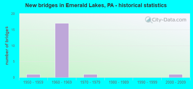
- New bridges - historical statistics
- 11950-1959
- 171960-1969
- 11970-1979
- 12000-2009

- Reconstructed bridges - Historical Statistics
- 51970-1979
- 11980-1989
- 01990-1999
- 12000-2009


- Bridge Condition - Deck
- 10.0%Good
- 70.0%Satisfactory
- 10.0%Fair
- 10.0%Poor

- Bridge Condition - Superstructure
- 40.0%Good
- 30.0%Satisfactory
- 20.0%Fair
- 10.0%Poor

- Bridge Condition - Substructure
- 20.0%Good
- 60.0%Satisfactory
- 20.0%Fair

- Bridge Condition - Channel
- 25.0%Very good
- 50.0%Good
- 25.0%Satisfactory
Find on map >> Show street view
Structure Number: 3534, Location: Bradys Run Park Bridge (Lat: 40.722111, Lng: -80.368806), Route carried "on" structure: Interstate 376, Year Built: 1971, Year Reconstructed: 2011, Status: Open, Structure Length: 41.45m (135.99ft), Average Daily Traffic: 11,829 (year 2021), Truck Traffic: 11%, Average Future Daily Traffic: 11,828 (year 2032), Design Load: HS 20, Features Intersected: SR 4012, BRADYS RUN PK.
Minimum Vertical Clearance: 30+ m (98+ ft), Kilometerpoint: 4.360, Lanes on structure: 2, Lanes under structure: 2, Base Highway Network: Yes, Owner: State Highway Agency, Approaching Roadway Width: 14.3m (46.9ft), Skew: 19 degrees, Material/Design: Steel continuous, Design/Construction: Girder and Floorbeam System, Number Of Spans In Main Unit: 7, Length of Maximum Span: 74.4m (244.1ft), Curb or Sidewalk Widths: Left: 0.2m (0.7ft), Right: 0.2m (0.7ft), Curb-To-Curb Width: 12.2m (40.0ft), Out-to-Out Width: 13.5m (44.3ft)
Condition: Deck: Satisfactory, Superstructure: Fair, Substructure: Satisfactory, Channel: Good, Operating Rating: 51.7 metric tons, Method Used To Determine Operating Rating: Load Factor (LF), Inventory Rating: 30.8 metric tons, Method Used To Determine Inventory Rating: Load Factor (LF), Structural Evaluation: Somewhat better than minimum adequacy, Deck Geometry: Better than present minimum criteria, Underclear: Superior to present desirable criteria, Waterway Adequacy: Superior to present desirable criteria, Approach Roadway Alignment: Equal to present desirable criteria, Length Of Structure Improvement: 41.50m (136.15ft), Designated Inspection Frequency: Every 24 months, Critical Feature Inspection Frequency: Every 24 months, Inspection Date: May 2020, Critical Feature Inspection Date: May 2020, Bridge Improvement Cost: $544,000, Roadway Improvement Cost: $1,603,000, Total Project Cost: $7,346,000, Deck Structure Type: Concrete Cast-file-Place, Wearing Surface/Protective System: Wearing Surface: Latex Concrete
Find on map >> Show street view
Structure Number: 26691, Location: I-80WB/I380SB TO I-80EB (Lat: 41.074408, Lng: -75.397153), Route carried "on" structure: Interstate 80, Year Built: 1964, Year Reconstructed: 1984, Status: Open, Structure Length: 1.52m (4.99ft), Average Daily Traffic: 20,743 (year 2021), Truck Traffic: 26%, Average Future Daily Traffic: 29,198 (year 2032), Design Load: HS 20+Mod, Features Intersected: I-380 SB
Minimum Vertical Clearance: 30+ m (98+ ft), Kilometerpoint: 16.546, Lanes on structure: 2, Lanes under structure: 2, Base Highway Network: Yes, Owner: State Highway Agency, Approaching Roadway Width: 12.5m (41.0ft), Skew: 2 degrees, Material/Design: Prestressed concrete, Design/Construction: Box Beam or Girders - Single/Spread, Number Of Spans In Main Unit: 1, Length of Maximum Span: 14.3m (46.9ft), Curb-To-Curb Width: 12.5m (41.0ft), Out-to-Out Width: 13.9m (45.6ft)
Condition: Deck: Satisfactory, Superstructure: Good, Substructure: Satisfactory, Operating Rating: 65.3 metric tons, Method Used To Determine Operating Rating: Load Factor (LF), Inventory Rating: 39.0 metric tons, Method Used To Determine Inventory Rating: Load Factor (LF), Structural Evaluation: Equal to present minimum criteria, Deck Geometry: Better than present minimum criteria, Underclear: Meets minimum limits, Approach Roadway Alignment: Equal to present desirable criteria, Length Of Structure Improvement: 2.20m (7.22ft), Designated Inspection Frequency: Every 24 months, Inspection Date: October 2021, Deck Structure Type: Concrete Cast-file-Place, Wearing Surface/Protective System: Wearing Surface: Monolithic Concrete, Deck Protection: Epoxy Coated Reinforcing
Find on map >> Show street view
Structure Number: 26694, Location: 8 MI.W. OF PA 33 (Lat: 41.062486, Lng: -75.372172), Route carried "on" structure: Interstate 80, Year Built: 1962, Status: Open, Structure Length: 0.70m (2.30ft), Average Daily Traffic: 20,897 (year 2021), Truck Traffic: 32%, Average Future Daily Traffic: 33,672 (year 2032), Design Load: HS 20+Mod, Features Intersected: DRY SAWMILL RUN
Minimum Vertical Clearance: 30+ m (98+ ft), Kilometerpoint: 18.720, Lanes on structure: 2, Base Highway Network: Yes, Owner: State Highway Agency, Approaching Roadway Width: 13.1m (43.0ft), Skew: 4 degrees, Material/Design: Concrete, Design/Construction: Culvert, Number Of Spans In Main Unit: 1, Length of Maximum Span: 7.0m (23.0ft)
Condition: Channel: Good, Culverts: Satisfactory, Inventory Rating: 90.7 metric tons, Method Used To Determine Inventory Rating: Field evaluation and documented engineering judgment, Structural Evaluation: Equal to present minimum criteria, Waterway Adequacy: Superior to present desirable criteria, Approach Roadway Alignment: Equal to present desirable criteria, Length Of Structure Improvement: 1.30m (4.27ft), Designated Inspection Frequency: Every 24 months, Inspection Date: June 2020
Find on map >> Show street view
Structure Number: 26826, Location: 0.9 MI.N.OF I-80 (Lat: 41.089925, Lng: -75.396081), Route carried "on" structure: Interstate 380, Year Built: 1964, Year Reconstructed: 1983, Status: Open, Structure Length: 1.16m (3.81ft), Average Daily Traffic: 14,003 (year 2021), Truck Traffic: 22%, Average Future Daily Traffic: 16,992 (year 2032), Design Load: HS 20+Mod, Features Intersected: SR 4004 (LR 45024)
Minimum Vertical Clearance: 30+ m (98+ ft), Kilometerpoint: 2.280, Lanes on structure: 2, Lanes under structure: 2, Base Highway Network: Yes, Owner: State Highway Agency, Approaching Roadway Width: 12.8m (42.0ft), Skew: 13 degrees, Material/Design: Prestressed concrete, Design/Construction: Box Beam or Girders - Single/Spread, Number Of Spans In Main Unit: 1, Length of Maximum Span: 11.0m (36.1ft), Curb-To-Curb Width: 12.2m (40.0ft), Out-to-Out Width: 13.3m (43.6ft)
Condition: Deck: Satisfactory, Superstructure: Good, Substructure: Fair, Operating Rating: 55.3 metric tons, Method Used To Determine Operating Rating: Load Factor (LF), Inventory Rating: 32.7 metric tons, Method Used To Determine Inventory Rating: Load Factor (LF), Structural Evaluation: Somewhat better than minimum adequacy, Deck Geometry: Better than present minimum criteria, Underclear: Meets minimum limits, Approach Roadway Alignment: Equal to present desirable criteria, Length Of Structure Improvement: 1.80m (5.91ft), Designated Inspection Frequency: Every 24 months, Inspection Date: July 2021, Deck Structure Type: Concrete Cast-file-Place, Wearing Surface/Protective System: Wearing Surface: Bituminous, Deck Protection: Epoxy Coated Reinforcing
Find on map >> Show street view
Structure Number: 26827, Location: 0.9 MI.N.OF I-80 (Lat: 41.089767, Lng: -75.395619), Route carried "on" structure: Interstate 380, Year Built: 1964, Year Reconstructed: 1983, Status: Open, Structure Length: 1.16m (3.81ft), Average Daily Traffic: 15,552 (year 2021), Truck Traffic: 18%, Average Future Daily Traffic: 17,499 (year 2032), Design Load: HS 20+Mod, Features Intersected: SR 4004 (LR 45024)
Minimum Vertical Clearance: 30+ m (98+ ft), Kilometerpoint: 1.720, Lanes on structure: 2, Lanes under structure: 2, Base Highway Network: Yes, Owner: State Highway Agency, Approaching Roadway Width: 12.8m (42.0ft), Skew: 13 degrees, Material/Design: Prestressed concrete, Design/Construction: Box Beam or Girders - Single/Spread, Number Of Spans In Main Unit: 1, Length of Maximum Span: 11.0m (36.1ft), Curb-To-Curb Width: 12.2m (40.0ft), Out-to-Out Width: 13.3m (43.6ft)
Condition: Deck: Satisfactory, Superstructure: Good, Substructure: Fair, Operating Rating: 55.3 metric tons, Method Used To Determine Operating Rating: Load Factor (LF), Inventory Rating: 32.7 metric tons, Method Used To Determine Inventory Rating: Load Factor (LF), Structural Evaluation: Somewhat better than minimum adequacy, Deck Geometry: Better than present minimum criteria, Underclear: High priority of corrective action, Approach Roadway Alignment: Equal to present desirable criteria, Length Of Structure Improvement: 1.80m (5.91ft), Designated Inspection Frequency: Every 24 months, Inspection Date: July 2021, Deck Structure Type: Concrete Cast-file-Place, Wearing Surface/Protective System: Wearing Surface: Bituminous, Deck Protection: Epoxy Coated Reinforcing
Find on map >> Show street view
Structure Number: 26911, Location: I-380 INTERCHANGE (Lat: 41.106053, Lng: -75.397928), Route carried "on" structure: State highway 940, Year Built: 1964, Year Reconstructed: 1985, Status: Open, Structure Length: 7.44m (24.41ft), Average Daily Traffic: 20,390 (year 2021), Truck Traffic: 7%, Average Future Daily Traffic: 26,202 (year 2032), Design Load: HS 20, Features Intersected: I-380(LR 1002)
Minimum Vertical Clearance: 30+ m (98+ ft), Kilometerpoint: 19.800, Lanes on structure: 4, Lanes under structure: 8, Owner: State Highway Agency, Approaching Roadway Width: 21.9m (71.9ft), Skew: 21 degrees, Material/Design: Prestressed concrete, Design/Construction: Box Beam or Girders - Single/Spread, Number Of Spans In Main Unit: 4, Length of Maximum Span: 23.8m (78.1ft), Curb-To-Curb Width: 18.6m (61.0ft), Out-to-Out Width: 20.0m (65.6ft)
Condition: Deck: Fair, Superstructure: Satisfactory, Substructure: Satisfactory, Operating Rating: 50.8 metric tons, Method Used To Determine Operating Rating: Load Factor (LF), Inventory Rating: 21.8 metric tons, Method Used To Determine Inventory Rating: Load Factor (LF), Structural Evaluation: Somewhat better than minimum adequacy, Deck Geometry: Equal to present minimum criteria, Underclear: Meets minimum limits, Approach Roadway Alignment: Equal to present desirable criteria, Length Of Structure Improvement: 8.40m (27.56ft), Designated Inspection Frequency: Every 24 months, Inspection Date: September 2020, Bridge Improvement Cost: $79,000, Roadway Improvement Cost: $233,000, Total Project Cost: $1,068,000, Deck Structure Type: Concrete Cast-file-Place, Wearing Surface/Protective System: Wearing Surface: Epoxy Overlay, Deck Protection: Epoxy Coated Reinforcing
Find on map >> Show street view
Structure Number: 27052, Location: OVER I-80 (Lat: 41.071539, Lng: -75.447275), Route carried "on" structure: State highway , Year Built: 1965, Status: Open, Structure Length: 6.34m (20.80ft), Average Daily Traffic: 3,111 (year 2022), Truck Traffic: 5%, Average Future Daily Traffic: 4,132 (year 2032), Design Load: HL 93, Features Intersected: SR 80(LR1009), Facility Carried by Structure: SR 4002 (LR 45040)
Minimum Vertical Clearance: 30+ m (98+ ft), Kilometerpoint: 8.813, Lanes on structure: 2, Lanes under structure: 8, Owner: State Highway Agency, Approaching Roadway Width: 6.1m (20.0ft), Skew: 1 degrees, Material/Design: Prestressed concrete, Design/Construction: Box Beam or Girders - Single/Spread, Number Of Spans In Main Unit: 4, Length of Maximum Span: 20.4m (66.9ft), Curb or Sidewalk Widths: Left: 0.5m (1.6ft), Right: 0.5m (1.6ft), Curb-To-Curb Width: 8.5m (27.9ft), Out-to-Out Width: 10.2m (33.5ft)
Condition: Deck: Satisfactory, Superstructure: Satisfactory, Substructure: Satisfactory, Operating Rating: 53.5 metric tons, Method Used To Determine Operating Rating: Load and Resistance Factor (LRFR), Inventory Rating: 14.5 metric tons, Method Used To Determine Inventory Rating: Load and Resistance Factor (LRFR), Structural Evaluation: Meets minimum limits, Deck Geometry: Meets minimum limits, Underclear: High priority of corrective action, Approach Roadway Alignment: Equal to present desirable criteria, Length Of Structure Improvement: 7.30m (23.95ft), Designated Inspection Frequency: Every 24 months, Inspection Date: December 2020, Bridge Improvement Cost: $30,000, Roadway Improvement Cost: $88,000, Total Project Cost: $403,000, Deck Structure Type: Concrete Cast-file-Place, Wearing Surface/Protective System: Wearing Surface: Latex Concrete
Find on map >> Show street view
Structure Number: 2711, Location: 0.5 M. N OF SR 4006 (Lat: 41.061739, Lng: -75.359842), Route carried "on" structure: City street 7209, Year Built: 1955, Status: Posted for load, Structure Length: 1.01m (3.31ft), Average Daily Traffic: 50 (year 1990), Average Future Daily Traffic: 100 (year 2030), Design Load: HS 20, Features Intersected: POCONO CREEK, Facility Carried by Structure: WILKE ROAD (T-539)
Minimum Vertical Clearance: 30+ m (98+ ft), Kilometerpoint: 0.000, Lanes on structure: 2, Owner: Town or Township Highway Agency, Approaching Roadway Width: 5.2m (17.1ft), Skew: 1 degrees, Material/Design: Prestressed concrete, Design/Construction: Box Beam or Girders - Multiple, Number Of Spans In Main Unit: 1, Length of Maximum Span: 9.4m (30.8ft), Curb or Sidewalk Widths: Left: 0.2m (0.7ft), Right: 0.2m (0.7ft), Curb-To-Curb Width: 5.1m (16.7ft), Out-to-Out Width: 5.6m (18.4ft)
Condition: Deck: Poor, Superstructure: Poor, Substructure: Good, Channel: Satisfactory, Operating Rating: 22.7 metric tons, Method Used To Determine Operating Rating: Load Factor (LF), Inventory Rating: 10.9 metric tons, Method Used To Determine Inventory Rating: Load Factor (LF), Structural Evaluation: Meets minimum limits, Deck Geometry: High priority of corrective action, Waterway Adequacy: Equal to present desirable criteria, Approach Roadway Alignment: Equal to present desirable criteria, Bridge Posting: Required (Relationship of Operating Rating to Maximum Legal Load: > 39.9% below), Length Of Structure Improvement: 1.00m (3.28ft), Designated Inspection Frequency: Every 24 months, Other Special Inspection Frequency: Every 12 months, Inspection Date: April 2020, Other Special Inspection Date: April 2021, Bridge Improvement Cost: $1,000, Roadway Improvement Cost: $6,000, Total Project Cost: $12,000, Deck Structure Type: Other, Wearing Surface/Protective System: Wearing Surface: Bituminous
Find on map >> Show street view
Structure Number: 2713, Location: I-80,I-380 INTERCHANGE (Lat: 41.070950, Lng: -75.394994), Route carried "on" structure: Ramp State highway , Year Built: 1964, Year Reconstructed: 1984, Status: Open, Structure Length: 3.99m (13.09ft), Average Daily Traffic: 2,305 (year 2021), Truck Traffic: 7%, Average Future Daily Traffic: 2,762 (year 2032), Design Load: HS 20, Features Intersected: I-380 SB, Facility Carried by Structure: SR8004(LR1002RAMP)
Minimum Vertical Clearance: 30+ m (98+ ft), Kilometerpoint: 0.000, Lanes on structure: 1, Lanes under structure: 2, Base Highway Network: Yes, Owner: State Highway Agency, Approaching Roadway Width: 9.1m (29.9ft), Skew: 1 degrees, Material/Design: Prestressed concrete, Design/Construction: Box Beam or Girders - Single/Spread, Number Of Spans In Main Unit: 3, Length of Maximum Span: 14.3m (46.9ft), Curb or Sidewalk Widths: Left: 0.2m (0.7ft), Right: 0.2m (0.7ft), Curb-To-Curb Width: 9.4m (30.8ft), Out-to-Out Width: 10.8m (35.4ft)
Condition: Deck: Satisfactory, Superstructure: Satisfactory, Substructure: Satisfactory, Operating Rating: 76.2 metric tons, Method Used To Determine Operating Rating: Load Factor (LF), Inventory Rating: 45.4 metric tons, Method Used To Determine Inventory Rating: Load Factor (LF), Structural Evaluation: Equal to present minimum criteria, Deck Geometry: Superior to present desirable criteria, Underclear: Meets minimum limits, Approach Roadway Alignment: Equal to present desirable criteria, Length Of Structure Improvement: 4.80m (15.75ft), Designated Inspection Frequency: Every 48 months, Inspection Date: November 2019, Bridge Improvement Cost: $36,000, Roadway Improvement Cost: $106,000, Total Project Cost: $485,000, Deck Structure Type: Concrete Cast-file-Place, Wearing Surface/Protective System: Wearing Surface: Monolithic Concrete, Deck Protection: Epoxy Coated Reinforcing
Find on map >> Show street view
Structure Number: 27131, Location: I-80 EB TO I-380 NB (Lat: 41.074114, Lng: -75.393972), Route carried "on" structure: Ramp State highway , Year Built: 1964, Year Reconstructed: 1984, Status: Open, Structure Length: 5.49m (18.01ft), Average Daily Traffic: 2,305 (year 2021), Truck Traffic: 7%, Average Future Daily Traffic: 2,762 (year 2032), Design Load: HS 20, Features Intersected: I-80 WB(LR 1002), Facility Carried by Structure: SR8004(LR1002RAMP)
Minimum Vertical Clearance: 30+ m (98+ ft), Kilometerpoint: 0.000, Lanes on structure: 1, Lanes under structure: 2, Base Highway Network: Yes, Owner: State Highway Agency, Approaching Roadway Width: 9.8m (32.2ft), Skew: 3 degrees, Material/Design: Prestressed concrete, Design/Construction: Box Beam or Girders - Single/Spread, Number Of Spans In Main Unit: 3, Length of Maximum Span: 22.6m (74.1ft), Curb-To-Curb Width: 9.4m (30.8ft), Out-to-Out Width: 10.8m (35.4ft)
Condition: Deck: Satisfactory, Superstructure: Fair, Substructure: Satisfactory, Operating Rating: 71.7 metric tons, Method Used To Determine Operating Rating: Load Factor (LF), Inventory Rating: 42.6 metric tons, Method Used To Determine Inventory Rating: Load Factor (LF), Structural Evaluation: Somewhat better than minimum adequacy, Deck Geometry: Superior to present desirable criteria, Underclear: Meets minimum limits, Approach Roadway Alignment: Equal to present desirable criteria, Length Of Structure Improvement: 6.40m (21.00ft), Designated Inspection Frequency: Every 24 months, Inspection Date: November 2019, Deck Structure Type: Concrete Cast-file-Place, Wearing Surface/Protective System: Wearing Surface: Monolithic Concrete, Deck Protection: Epoxy Coated Reinforcing
Find on map >> Show street view
Structure Number: 40773, Location: LONG POND RD EMERALD LAKE (Lat: 41.082328, Lng: -75.430292), Route carried "on" structure: State highway , Year Built: 2000, Status: Open, Structure Length: 1.95m (6.40ft), Average Daily Traffic: 3,111 (year 2022), Truck Traffic: 5%, Average Future Daily Traffic: 4,132 (year 2032), Design Load: HS 25 or greater, Features Intersected: EMERALD LAKE, Facility Carried by Structure: SR 4002(LR 45040)
Minimum Vertical Clearance: 30+ m (98+ ft), Kilometerpoint: 11.277, Lanes on structure: 2, Owner: State Highway Agency, Approaching Roadway Width: 9.1m (29.9ft), Material/Design: Prestressed concrete, Design/Construction: Box Beam or Girders - Multiple, Number Of Spans In Main Unit: 1, Length of Maximum Span: 19.2m (63.0ft), Curb or Sidewalk Widths: Left: 0.1m (0.3ft), Right: 0.1m (0.3ft), Curb-To-Curb Width: 10.2m (33.5ft), Out-to-Out Width: 11.1m (36.4ft)
Condition: Deck: Good, Superstructure: Good, Substructure: Good, Channel: Very good, Inventory Rating: 56.2 metric tons, Method Used To Determine Inventory Rating: Load Factor (LF), Structural Evaluation: Better than present minimum criteria, Deck Geometry: Meets minimum limits, Waterway Adequacy: Equal to present desirable criteria, Approach Roadway Alignment: Equal to present minimum criteria, Length Of Structure Improvement: 2.70m (8.86ft), Designated Inspection Frequency: Every 48 months, Inspection Date: April 2020, Deck Structure Type: Concrete Cast-file-Place, Wearing Surface/Protective System: Wearing Surface: Monolithic Concrete, Deck Protection: Epoxy Coated Reinforcing
Find on map >> Show street view
Structure Number: 26691, Location: I-80WB/I380SB TO I-80EB (Lat: 41.074408, Lng: -75.397153), Route carried "under" structure: Interstate 380, Year Built: 1964, Structure Length: 0. m, Average Daily Traffic: 14,003 (year 2021), Truck Traffic: 22%, Features Intersected: I-380 SB, Facility Carried by Structure: I-80 WB
Minimum Vertical Clearance: 5.12m (16.80ft), Kilometerpoint: 0.000, Lanes on structure: 2, Lanes under structure: 2, Material/Design: Prestressed concrete, Design/Construction: Box Beam or Girders - Single/Spread, Length of Maximum Span: 14.3m (46.9ft)
Find on map >> Show street view
Structure Number: 26826, Location: 0.9 MI.N.OF I-80 (Lat: 41.089925, Lng: -75.396081), Route carried "under" structure: State highway , Year Built: 1964, Structure Length: 0. m, Average Daily Traffic: 1,207 (year 2020), Truck Traffic: 5%, Features Intersected: SR 4004 (LR 45024), Facility Carried by Structure: I-380 SB(LR 1002)
Minimum Vertical Clearance: 4.94m (16.21ft), Kilometerpoint: 9.912, Lanes on structure: 2, Lanes under structure: 2, Material/Design: Prestressed concrete, Design/Construction: Box Beam or Girders - Single/Spread, Length of Maximum Span: 11.0m (36.1ft)
Find on map >> Show street view
Structure Number: 26827, Location: 0.9 MI.N.OF I-80 (Lat: 41.089767, Lng: -75.395619), Route carried "under" structure: State highway , Year Built: 1964, Structure Length: 0. m, Average Daily Traffic: 1,207 (year 2020), Truck Traffic: 5%, Features Intersected: SR 4004 (LR 45024), Facility Carried by Structure: I-380 NB (LR 1002)
Minimum Vertical Clearance: 4.66m (15.29ft), Kilometerpoint: 9.139, Lanes on structure: 2, Lanes under structure: 2, Material/Design: Prestressed concrete, Design/Construction: Box Beam or Girders - Single/Spread, Length of Maximum Span: 11.0m (36.1ft)
Find on map >> Show street view
Structure Number: 26911, Location: I-380 INTERCHANGE (Lat: 41.106053, Lng: -75.397928), Route carried "under" structure: Interstate 380, Year Built: 1964, Structure Length: 0. m, Average Daily Traffic: 12,229 (year 2021), Truck Traffic: 23%, Features Intersected: I-380(LR 1002), Facility Carried by Structure: PA 940(LR 169)
Minimum Vertical Clearance: 5.00m (16.40ft), Kilometerpoint: 4.142, Lanes on structure: 4, Lanes under structure: 4, Material/Design: Prestressed concrete, Design/Construction: Box Beam or Girders - Single/Spread, Length of Maximum Span: 23.8m (78.1ft)
Find on map >> Show street view
Structure Number: 26911, Location: I-380 INTERCHANGE (Lat: 41.106053, Lng: -75.397928), Route carried "under" structure: Interstate 380, Year Built: 1964, Structure Length: 0. m, Average Daily Traffic: 12,281 (year 2021), Truck Traffic: 22%, Features Intersected: I-380(LR 1002), Facility Carried by Structure: PA 940(LR 169)
Minimum Vertical Clearance: 5.03m (16.50ft), Kilometerpoint: 4.693, Lanes on structure: 4, Lanes under structure: 4, Material/Design: Prestressed concrete, Design/Construction: Box Beam or Girders - Single/Spread, Length of Maximum Span: 23.8m (78.1ft)
Find on map >> Show street view
Structure Number: 27052, Location: OVER I-80 (Lat: 41.071539, Lng: -75.447275), Route carried "under" structure: Interstate 80, Year Built: 1965, Structure Length: 0. m, Average Daily Traffic: 14,334 (year 2021), Truck Traffic: 22%, Features Intersected: SR 80(LR1009), Facility Carried by Structure: SR 4002 (LR 45040)
Minimum Vertical Clearance: 5.03m (16.50ft), Kilometerpoint: 11.724, Lanes on structure: 2, Lanes under structure: 4, Material/Design: Prestressed concrete, Design/Construction: Box Beam or Girders - Single/Spread, Length of Maximum Span: 20.4m (66.9ft)
Find on map >> Show street view
Structure Number: 27052, Location: OVER I-80 (Lat: 41.071539, Lng: -75.447275), Route carried "under" structure: Interstate 80, Year Built: 1965, Structure Length: 0. m, Average Daily Traffic: 14,052 (year 2021), Truck Traffic: 22%, Features Intersected: SR 80(LR1009), Facility Carried by Structure: SR 4002 (LR 45040)
Minimum Vertical Clearance: 4.94m (16.21ft), Kilometerpoint: 12.270, Lanes on structure: 2, Lanes under structure: 4, Material/Design: Prestressed concrete, Design/Construction: Box Beam or Girders - Single/Spread, Length of Maximum Span: 20.4m (66.9ft)
Find on map >> Show street view
Structure Number: 2713, Location: I-80,I-380 INTERCHANGE (Lat: 41.070950, Lng: -75.394994), Route carried "under" structure: Interstate 380, Year Built: 1964, Structure Length: 0. m, Average Daily Traffic: 14,003 (year 2021), Truck Traffic: 22%, Features Intersected: I-380 SB, Facility Carried by Structure: SR8004(LR1002RAMP)
Minimum Vertical Clearance: 5.24m (17.19ft), Kilometerpoint: 0.000, Lanes on structure: 1, Lanes under structure: 2, Material/Design: Prestressed concrete, Design/Construction: Box Beam or Girders - Single/Spread, Length of Maximum Span: 14.3m (46.9ft)
Find on map >> Show street view
Structure Number: 27131, Location: I-80 EB TO I-380 NB (Lat: 41.074114, Lng: -75.393972), Route carried "under" structure: Interstate 80, Year Built: 1964, Structure Length: 0. m, Average Daily Traffic: 20,743 (year 2021), Truck Traffic: 26%, Features Intersected: I-80 WB(LR 1002)
Minimum Vertical Clearance: 5.36m (17.59ft), Kilometerpoint: 16.546, Lanes on structure: 1, Lanes under structure: 2, Material/Design: Prestressed concrete, Design/Construction: Box Beam or Girders - Single/Spread, Length of Maximum Span: 22.6m (74.1ft)