Bridge Statistics for Elyria, Nebraska (NE)
Condition, Traffic, Stress, Structural Evaluation, Project Costs
- National Bridge Inventory (NBI) Statistics
- 13Number of bridges
- 92ft / 28.2mTotal length
- 9,945Total average daily traffic
- 937Total average daily truck traffic
- 11,957Total future (year 2033) average daily traffic
- National Bridge Inventory (NBI) Registered Bridges for Elyria
- No street view available for this location
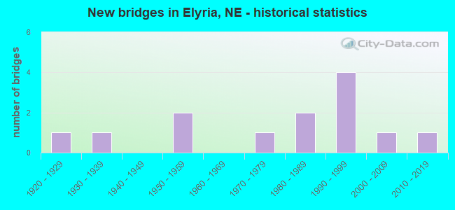
- New bridges - historical statistics
- 11920-1929
- 11930-1939
- 21950-1959
- 11970-1979
- 21980-1989
- 41990-1999
- 12000-2009
- 12010-2019

- Reconstructed bridges - Historical Statistics
- 11970-1979
- 11980-1989

- Bridge Condition - Deck
- 12.5%Excellent
- 25.0%Very good
- 37.5%Good
- 12.5%Satisfactory
- 12.5%Fair

- Bridge Condition - Superstructure
- 12.5%Excellent
- 12.5%Very good
- 62.5%Good
- 12.5%Satisfactory

- Bridge Condition - Substructure
- 12.5%Excellent
- 12.5%Very good
- 37.5%Good
- 12.5%Satisfactory
- 12.5%Fair
- 12.5%Poor

- Bridge Condition - Channel
- 30.8%Excellent
- 46.2%Very good
- 7.7%Good
- 7.7%Satisfactory
- 7.7%Fair

- Bridge Condition - Culverts
- 80.0%Very good
- 20.0%Good
Find on map >> Show street view
Structure Number: C00880182, Location: 5.2W 1N ORD (Lat: 41.625000, Lng: -99.040000), Route carried "on" structure: County highway 18, Year Built: 1986, Status: Open, Structure Length: 1.86m (6.10ft), Average Daily Traffic: 50 (year 2003), Truck Traffic: 15%, Average Future Daily Traffic: 85 (year 2033), Features Intersected: MIRDAN CANAL, Facility Carried by Structure: COUNTY HIGHWAY
Minimum Vertical Clearance: 30+ m (98+ ft), Kilometerpoint: 0.000, Lanes on structure: 2, Owner: County Highway Agency, Approaching Roadway Width: 8.5m (27.9ft), Material/Design: Prestressed concrete, Design/Construction: Stringer/Multi-beam, Number Of Spans In Main Unit: 1, Length of Maximum Span: 18.0m (59.1ft), Curb or Sidewalk Widths: Left: 0.5m (1.6ft), Right: 0.5m (1.6ft), Curb-To-Curb Width: 8.5m (27.9ft), Out-to-Out Width: 9.4m (30.8ft)
Condition: Deck: Very good, Superstructure: Good, Substructure: Good, Channel: Excellent, Operating Rating: 40.0 metric tons, Method Used To Determine Operating Rating: Load Factor (LF), Inventory Rating: 23.0 metric tons, Method Used To Determine Inventory Rating: Load Factor (LF), Structural Evaluation: Equal to present minimum criteria, Deck Geometry: Better than present minimum criteria, Waterway Adequacy: Superior to present desirable criteria, Approach Roadway Alignment: Equal to present desirable criteria, Designated Inspection Frequency: Every 24 months, Inspection Date: November 2021, Deck Structure Type: Concrete Cast-file-Place, Wearing Surface/Protective System: Wearing Surface: Monolithic Concrete
Find on map >> Show street view
Structure Number: C008801905P, Location: 4.5W 3N ORD (Lat: 41.658300, Lng: -99.030000), Route carried "on" structure: County highway P19, Year Built: 1920, Year Reconstructed: 1988, Status: Open, Structure Length: 1.16m (3.81ft), Average Daily Traffic: 65 (year 2003), Truck Traffic: 15%, Average Future Daily Traffic: 110 (year 2033), Features Intersected: TURTLE CREEK, Facility Carried by Structure: COUNTY HIGHWAY
Minimum Vertical Clearance: 30+ m (98+ ft), Kilometerpoint: 0.000, Lanes on structure: 2, Owner: County Highway Agency, Approaching Roadway Width: 8.5m (27.9ft), Material/Design: Steel, Design/Construction: Stringer/Multi-beam, Number Of Spans In Main Unit: 1, Length of Maximum Span: 11.0m (36.1ft), Curb-To-Curb Width: 7.3m (24.0ft), Out-to-Out Width: 7.5m (24.6ft)
Condition: Deck: Satisfactory, Superstructure: Good, Substructure: Fair, Channel: Fair, Operating Rating: 53.0 metric tons, Method Used To Determine Operating Rating: Load Factor (LF), Inventory Rating: 31.0 metric tons, Method Used To Determine Inventory Rating: Load Factor (LF), Structural Evaluation: Somewhat better than minimum adequacy, Deck Geometry: Equal to present minimum criteria, Waterway Adequacy: Superior to present desirable criteria, Approach Roadway Alignment: Equal to present desirable criteria, Designated Inspection Frequency: Every 24 months, Inspection Date: November 2021, Deck Structure Type: Concrete Cast-file-Place, Wearing Surface/Protective System: Wearing Surface: Monolithic Concrete
Find on map >> Show street view
Structure Number: C008801910P, Location: 4.5W 3.6N ORD (Lat: 41.666700, Lng: -99.030000), Route carried "on" structure: County highway P19, Year Built: 1970, Status: Posted for load, Structure Length: 1.22m (4.00ft), Average Daily Traffic: 40 (year 2003), Truck Traffic: 15%, Average Future Daily Traffic: 68 (year 2033), Features Intersected: N BR TURTLE CREEK, Facility Carried by Structure: COUNTY HIGHWAY
Minimum Vertical Clearance: 30+ m (98+ ft), Kilometerpoint: 0.000, Lanes on structure: 2, Owner: County Highway Agency, Approaching Roadway Width: 8.2m (26.9ft), Material/Design: Steel, Design/Construction: Stringer/Multi-beam, Number Of Spans In Main Unit: 1, Length of Maximum Span: 11.9m (39.0ft), Curb-To-Curb Width: 7.7m (25.3ft), Out-to-Out Width: 7.9m (25.9ft)
Condition: Deck: Fair, Superstructure: Good, Substructure: Good, Channel: Good, Operating Rating: 36.0 metric tons, Method Used To Determine Operating Rating: Load Factor (LF), Inventory Rating: 22.0 metric tons, Method Used To Determine Inventory Rating: Load Factor (LF), Structural Evaluation: Equal to present minimum criteria, Deck Geometry: Equal to present minimum criteria, Waterway Adequacy: Equal to present desirable criteria, Approach Roadway Alignment: Equal to present desirable criteria, Bridge Posting: Required (Relationship of Operating Rating to Maximum Legal Load: 0.1 - 9.9% below), Designated Inspection Frequency: Every 24 months, Inspection Date: November 2021, Deck Structure Type: Concrete Cast-file-Place, Wearing Surface/Protective System: Wearing Surface: Gravel
Find on map >> Show street view
Structure Number: C008810815P, Location: 1N .7W OF ELYRIA (Lat: 41.690000, Lng: -99.025300), Route carried "on" structure: County highway 7488, Year Built: 1950, Status: Open, Structure Length: 1.10m (3.61ft), Average Daily Traffic: 45 (year 1998), Average Future Daily Traffic: 76 (year 2033), Features Intersected: STREAM
Minimum Vertical Clearance: 30+ m (98+ ft), Kilometerpoint: 1.078, Lanes on structure: 2, Owner: County Highway Agency, Approaching Roadway Width: 6.7m (22.0ft), Material/Design: Steel, Design/Construction: Stringer/Multi-beam, Number Of Spans In Main Unit: 1, Length of Maximum Span: 10.7m (35.1ft), Curb or Sidewalk Widths: Left: 0.2m (0.7ft), Right: 0.2m (0.7ft), Curb-To-Curb Width: 6.1m (20.0ft), Out-to-Out Width: 6.5m (21.3ft)
Condition: Deck: Good, Superstructure: Good, Substructure: Satisfactory, Channel: Very good, Operating Rating: 42.0 metric tons, Method Used To Determine Operating Rating: Load Factor (LF), Inventory Rating: 25.0 metric tons, Method Used To Determine Inventory Rating: Load Factor (LF), Structural Evaluation: Equal to present minimum criteria, Deck Geometry: Somewhat better than minimum adequacy, Waterway Adequacy: Better than present minimum criteria, Approach Roadway Alignment: Equal to present minimum criteria, Designated Inspection Frequency: Every 24 months, Inspection Date: November 2021, Deck Structure Type: Concrete Cast-file-Place, Wearing Surface/Protective System: Wearing Surface: Monolithic Concrete
Find on map >> Show street view
Structure Number: C008811915P, Location: 4.5W 6.9N ORD (Lat: 41.721000, Lng: -99.030000), Route carried "on" structure: County highway 7483, Year Built: 2011, Status: Open, Structure Length: 2.32m (7.61ft), Average Daily Traffic: 50 (year 1998), Average Future Daily Traffic: 85 (year 2033), Design Load: HS 20, Features Intersected: BEAN CREEK, Facility Carried by Structure: FORT AVENUE
Minimum Vertical Clearance: 30+ m (98+ ft), Kilometerpoint: 5.060, Lanes on structure: 2, Owner: County Highway Agency, Approaching Roadway Width: 7.3m (24.0ft), Material/Design: Steel, Design/Construction: Stringer/Multi-beam, Number Of Spans In Main Unit: 3, Length of Maximum Span: 7.6m (24.9ft), Curb or Sidewalk Widths: Left: 0.1m (0.3ft), Right: 0.1m (0.3ft), Curb-To-Curb Width: 9.3m (30.5ft), Out-to-Out Width: 9.7m (31.8ft)
Condition: Deck: Excellent, Superstructure: Excellent, Substructure: Excellent, Channel: Excellent, Operating Rating: 42.0 metric tons, Method Used To Determine Operating Rating: Load Factor (LF), Inventory Rating: 33.0 metric tons, Method Used To Determine Inventory Rating: Load Factor (LF), Structural Evaluation: Superior to present desirable criteria, Deck Geometry: Better than present minimum criteria, Waterway Adequacy: Superior to present desirable criteria, Approach Roadway Alignment: Superior to present desirable criteria, Length Of Structure Improvement: 1.58m (5.18ft), Designated Inspection Frequency: Every 24 months, Inspection Date: June 2020, Deck Structure Type: Concrete Cast-file-Place, Wearing Surface/Protective System: Wearing Surface: Monolithic Concrete
Find on map >> Show street view
Structure Number: C008812105P, Location: WJCT N11/N70 6.2N 3.3W (Lat: 41.691800, Lng: -99.005800), Route carried "on" structure: County highway R88B, Year Built: 1980, Status: Open, Structure Length: 9.81m (32.19ft), Average Daily Traffic: 235 (year 2011), Average Future Daily Traffic: 265 (year 2033), Design Load: HS 20, Features Intersected: NORTH LOUP RIVER
Minimum Vertical Clearance: 30+ m (98+ ft), Kilometerpoint: 0.124, Lanes on structure: 2, Owner: County Highway Agency, Approaching Roadway Width: 9.1m (29.9ft), Skew: 2 degrees, Material/Design: Steel continuous, Design/Construction: Stringer/Multi-beam, Number Of Spans In Main Unit: 3, Length of Maximum Span: 37.8m (124.0ft), Curb-To-Curb Width: 8.6m (28.2ft), Out-to-Out Width: 9.2m (30.2ft)
Condition: Deck: Very good, Superstructure: Very good, Substructure: Very good, Channel: Excellent, Operating Rating: 49.0 metric tons, Method Used To Determine Operating Rating: Load Factor (LF), Inventory Rating: 29.0 metric tons, Method Used To Determine Inventory Rating: Load Factor (LF), Structural Evaluation: Better than present minimum criteria, Deck Geometry: Equal to present minimum criteria, Waterway Adequacy: Superior to present desirable criteria, Approach Roadway Alignment: Superior to present desirable criteria, Designated Inspection Frequency: Every 24 months, Inspection Date: November 2020, Deck Structure Type: Concrete Cast-file-Place, Wearing Surface/Protective System: Wearing Surface: Monolithic Concrete
Find on map >> Show street view
Structure Number: C00881272, Location: 3N 1W ORD (Lat: 41.658300, Lng: -98.963300), Route carried "on" structure: County highway 127, Year Built: 1950, Status: Posted for load, Structure Length: 1.92m (6.30ft), Average Daily Traffic: 30 (year 2003), Truck Traffic: 15%, Average Future Daily Traffic: 51 (year 2033), Features Intersected: TURTLE CREEK, Facility Carried by Structure: COUNTY RD 475 AVE
Minimum Vertical Clearance: 30+ m (98+ ft), Kilometerpoint: 0.000, Lanes on structure: 2, Owner: County Highway Agency, Approaching Roadway Width: 7.0m (23.0ft), Material/Design: Wood or Timber, Design/Construction: Stringer/Multi-beam, Number Of Spans In Main Unit: 4, Length of Maximum Span: 4.9m (16.1ft), Curb-To-Curb Width: 7.2m (23.6ft), Out-to-Out Width: 7.3m (24.0ft)
Condition: Deck: Good, Superstructure: Satisfactory, Substructure: Poor, Channel: Satisfactory, Operating Rating: 30.0 metric tons, Method Used To Determine Operating Rating: Allowable Stress (AS), Inventory Rating: 26.0 metric tons, Method Used To Determine Inventory Rating: Allowable Stress (AS), Structural Evaluation: Meets minimum limits, Deck Geometry: Somewhat better than minimum adequacy, Waterway Adequacy: Better than present minimum criteria, Approach Roadway Alignment: Equal to present desirable criteria, Bridge Posting: Required (Relationship of Operating Rating to Maximum Legal Load: 10.0 - 19.9% below), Length Of Structure Improvement: 1.92m (6.30ft), Designated Inspection Frequency: Every 24 months, Inspection Date: June 2020, Deck Structure Type: Concrete Cast-file-Place, Wearing Surface/Protective System: Wearing Surface: Monolithic Concrete
Find on map >> Show street view
Structure Number: C008820825P, Location: 2E OF ELYRIA (Lat: 41.684300, Lng: -98.959900), Route carried "on" structure: County highway 7483, Year Built: 1935, Year Reconstructed: 1970, Status: Open, Structure Length: 0.61m (2.00ft), Average Daily Traffic: 50 (year 1998), Average Future Daily Traffic: 85 (year 2033), Features Intersected: GRAVEL CREEK
Minimum Vertical Clearance: 30+ m (98+ ft), Kilometerpoint: 4.159, Lanes on structure: 2, Owner: County Highway Agency, Approaching Roadway Width: 6.7m (22.0ft), Material/Design: Steel, Design/Construction: Culvert, Number Of Spans In Main Unit: 3, Length of Maximum Span: 1.5m (4.9ft)
Condition: Channel: Very good, Culverts: Very good, Operating Rating: 42.0 metric tons, Method Used To Determine Operating Rating: Field evaluation and documented engineering judgment, Inventory Rating: 33.0 metric tons, Method Used To Determine Inventory Rating: Field evaluation and documented engineering judgment, Structural Evaluation: Equal to present desirable criteria, Waterway Adequacy: Better than present minimum criteria, Approach Roadway Alignment: Equal to present desirable criteria, Designated Inspection Frequency: Every 24 months, Inspection Date: November 2021
Find on map >> Show street view
Structure Number: S011 08103, Location: 5NW ORD (Lat: 41.658900, Lng: -98.983000), Route carried "on" structure: State highway 11, Year Built: 1996, Status: Open, Structure Length: 4.39m (14.40ft), Average Daily Traffic: 2,480 (year 2018), Truck Traffic: 9%, Average Future Daily Traffic: 2,852 (year 2038), Design Load: HS 25 or greater, Features Intersected: TURTLE CREEK
Minimum Vertical Clearance: 30+ m (98+ ft), Kilometerpoint: 13.040, Lanes on structure: 2, Base Highway Network: Yes, Owner: State Highway Agency, Approaching Roadway Width: 7.3m (24.0ft), Material/Design: Concrete continuous, Design/Construction: Slab, Number Of Spans In Main Unit: 3, Length of Maximum Span: 17.1m (56.1ft), Curb-To-Curb Width: 12.2m (40.0ft), Out-to-Out Width: 12.9m (42.3ft)
Condition: Deck: Good, Superstructure: Good, Substructure: Good, Channel: Very good, Operating Rating: 90.0 metric tons, Method Used To Determine Operating Rating: Load Factor (LF), Inventory Rating: 54.0 metric tons, Method Used To Determine Inventory Rating: Load Factor (LF), Structural Evaluation: Better than present minimum criteria, Deck Geometry: Equal to present minimum criteria, Waterway Adequacy: Equal to present desirable criteria, Approach Roadway Alignment: Equal to present desirable criteria, Designated Inspection Frequency: Every 24 months, Inspection Date: November 2020, Deck Structure Type: Concrete Cast-file-Place, Wearing Surface/Protective System: Wearing Surface: Monolithic Concrete, Deck Protection: Epoxy Coated Reinforcing
Find on map >> Show street view
Structure Number: S011 08353, Location: 8NW ORD (Lat: 41.687100, Lng: -99.013100), Route carried "on" structure: State highway 11, Year Built: 1996, Status: Open, Structure Length: 0.98m (3.22ft), Average Daily Traffic: 1,725 (year 2018), Truck Traffic: 10%, Average Future Daily Traffic: 2,070 (year 2038), Design Load: HS 20, Features Intersected: STREAM
Minimum Vertical Clearance: 30+ m (98+ ft), Kilometerpoint: 13.443, Lanes on structure: 2, Base Highway Network: Yes, Owner: State Highway Agency, Approaching Roadway Width: 7.3m (24.0ft), Material/Design: Concrete, Design/Construction: Culvert, Number Of Spans In Main Unit: 3, Length of Maximum Span: 3.0m (9.8ft)
Condition: Channel: Very good, Culverts: Very good, Operating Rating: 43.0 metric tons, Method Used To Determine Operating Rating: Field evaluation and documented engineering judgment, Inventory Rating: 33.0 metric tons, Method Used To Determine Inventory Rating: Field evaluation and documented engineering judgment, Structural Evaluation: Equal to present desirable criteria, Waterway Adequacy: Equal to present desirable criteria, Approach Roadway Alignment: Equal to present desirable criteria, Designated Inspection Frequency: Every 24 months, Inspection Date: November 2020
Find on map >> Show street view
Structure Number: S011 08448, Location: 9NW ORD (Lat: 41.696700, Lng: -99.026500), Route carried "on" structure: State highway 11, Year Built: 1996, Status: Open, Structure Length: 0.98m (3.22ft), Average Daily Traffic: 1,725 (year 2018), Truck Traffic: 10%, Average Future Daily Traffic: 2,070 (year 2038), Design Load: HS 20, Features Intersected: STREAM
Minimum Vertical Clearance: 30+ m (98+ ft), Kilometerpoint: 13.596, Lanes on structure: 2, Base Highway Network: Yes, Owner: State Highway Agency, Approaching Roadway Width: 7.3m (24.0ft), Material/Design: Concrete, Design/Construction: Culvert, Number Of Spans In Main Unit: 3, Length of Maximum Span: 3.0m (9.8ft)
Condition: Channel: Very good, Culverts: Very good, Operating Rating: 43.0 metric tons, Method Used To Determine Operating Rating: Field evaluation and documented engineering judgment, Inventory Rating: 33.0 metric tons, Method Used To Determine Inventory Rating: Field evaluation and documented engineering judgment, Structural Evaluation: Equal to present desirable criteria, Waterway Adequacy: Equal to present desirable criteria, Approach Roadway Alignment: Equal to present desirable criteria, Designated Inspection Frequency: Every 24 months, Inspection Date: November 2020
Find on map >> Show street view
Structure Number: S011 08472, Location: 9NW ORD (Lat: 41.699000, Lng: -99.029800), Route carried "on" structure: State highway 11, Year Built: 1996, Status: Open, Structure Length: 1.22m (4.00ft), Average Daily Traffic: 1,725 (year 2018), Truck Traffic: 10%, Average Future Daily Traffic: 2,070 (year 2038), Design Load: HS 20, Features Intersected: STREAM
Minimum Vertical Clearance: 30+ m (98+ ft), Kilometerpoint: 13.634, Lanes on structure: 2, Base Highway Network: Yes, Owner: State Highway Agency, Approaching Roadway Width: 7.3m (24.0ft), Skew: 1 degrees, Material/Design: Concrete, Design/Construction: Culvert, Number Of Spans In Main Unit: 3, Length of Maximum Span: 3.7m (12.1ft)
Condition: Channel: Very good, Culverts: Good, Operating Rating: 43.0 metric tons, Method Used To Determine Operating Rating: Field evaluation and documented engineering judgment, Inventory Rating: 33.0 metric tons, Method Used To Determine Inventory Rating: Field evaluation and documented engineering judgment, Structural Evaluation: Better than present minimum criteria, Waterway Adequacy: Equal to present desirable criteria, Approach Roadway Alignment: Equal to present desirable criteria, Designated Inspection Frequency: Every 24 months, Inspection Date: November 2020
Find on map >> Show street view
Structure Number: S011 08577, Location: 10NW ORD (Lat: 41.709400, Lng: -99.044400), Route carried "on" structure: State highway 11, Year Built: 2007, Status: Open, Structure Length: 0.67m (2.20ft), Average Daily Traffic: 1,725 (year 2018), Truck Traffic: 10%, Average Future Daily Traffic: 2,070 (year 2038), Design Load: HS 20, Features Intersected: STREAM
Minimum Vertical Clearance: 30+ m (98+ ft), Kilometerpoint: 13.803, Lanes on structure: 2, Base Highway Network: Yes, Owner: State Highway Agency, Approaching Roadway Width: 8.5m (27.9ft), Skew: 1 degrees, Material/Design: Concrete, Design/Construction: Culvert, Number Of Spans In Main Unit: 2, Length of Maximum Span: 3.0m (9.8ft)
Condition: Channel: Excellent, Culverts: Very good, Operating Rating: 43.0 metric tons, Method Used To Determine Operating Rating: Field evaluation and documented engineering judgment, Inventory Rating: 33.0 metric tons, Method Used To Determine Inventory Rating: Field evaluation and documented engineering judgment, Structural Evaluation: Equal to present desirable criteria, Waterway Adequacy: Superior to present desirable criteria, Approach Roadway Alignment: Equal to present desirable criteria, Designated Inspection Frequency: Every 24 months, Inspection Date: November 2020