Bridge Statistics for Elmwood, Louisiana (LA)
Condition, Traffic, Stress, Structural Evaluation, Project Costs
- National Bridge Inventory (NBI) Statistics
- 25Number of bridges
- 1,289ft / 393mTotal length
- 448,954Total average daily traffic
- 19,530Total average daily truck traffic
- National Bridge Inventory (NBI) Registered Bridges for Elmwood
- No street view available for this location
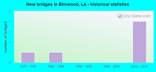
- New bridges - historical statistics
- 11970-1979
- 11980-1989
- 42010-2019


- Bridge Condition - Deck
- 20.0%Very good
- 60.0%Good
- 20.0%Satisfactory

- Bridge Condition - Superstructure
- 40.0%Very good
- 40.0%Good
- 20.0%Satisfactory

- Bridge Condition - Substructure
- 40.0%Very good
- 60.0%Good
Find on map >> Show street view
Structure Number: 22600000020459, Location: 1.5 MILES SOUTH OF US 61 (Lat: 29.968831, Lng: -90.192900), Route carried "on" structure: State highway 3139, Year Built: 1986, Status: Open, Structure Length: 0.76m (2.49ft), Average Daily Traffic: 33,214 (year 2016), Truck Traffic: 18%, Average Future Daily Traffic: 55,760 (year 2036), Design Load: HS 20, Features Intersected: DRAIN CANAL
Minimum Vertical Clearance: 30+ m (98+ ft), Kilometerpoint: 1.287, Lanes on structure: 6, Base Highway Network: Yes (Inventory Route: 430-01-1, Subroute: 10), Owner: State Highway Agency, Approaching Roadway Width: 11.6m (38.1ft), Skew: 30 degrees, Material/Design: Concrete, Design/Construction: Culvert, Number Of Spans In Main Unit: 3, Length of Maximum Span: 2.4m (7.9ft)
Condition: Channel: Good, Culverts: Good, Operating Rating: 97.2 metric tons, Method Used To Determine Operating Rating: Load and Resistance Factor Rating (LRFR) rating reported by rating factor(RF) method using HL-93 loadings, Inventory Rating: 74.5 metric tons, Method Used To Determine Inventory Rating: Load and Resistance Factor Rating (LRFR) rating reported by rating factor(RF) method using HL-93 loadings, Structural Evaluation: Better than present minimum criteria, Waterway Adequacy: Better than present minimum criteria, Approach Roadway Alignment: Equal to present desirable criteria, Designated Inspection Frequency: Every 24 months, Inspection Date: Febuary 2020
Find on map >> Show street view
Structure Number: 22600000020497, Location: 0.0 MI NORTH OF MISSISSIP (Lat: 29.945961, Lng: -90.170800), Route carried "on" structure: US 90, Year Built: 2013, Status: Open, Structure Length: 143.44m (470.60ft), Average Daily Traffic: 30,800 (year 2016), Truck Traffic: 10%, Average Future Daily Traffic: 61,506 (year 2036), Design Load: HS 20, Features Intersected: LA 48 AND LA 611-1
Minimum Vertical Clearance: 30+ m (98+ ft), Kilometerpoint: 2.445, Lanes on structure: 3, Lanes under structure: 10, Base Highway Network: Yes (Inventory Route: 6-01-1, Subroute: 10), Owner: State Highway Agency, Approaching Roadway Width: 13.7m (44.9ft), Skew: 30 degrees, Material/Design: Steel continuous, Design/Construction: Girder and Floorbeam System, Number Of Spans In Main Unit: 5, Number Of Approach Spans: 46, Length of Maximum Span: 73.2m (240.2ft), Curb-To-Curb Width: 13.7m (44.9ft), Out-to-Out Width: 14.6m (47.9ft)
Condition: Deck: Good, Superstructure: Good, Substructure: Good, Operating Rating: 40.5 metric tons, Method Used To Determine Operating Rating: Load and Resistance Factor Rating (LRFR) rating reported by rating factor(RF) method using HL-93 loadings, Inventory Rating: 29.2 metric tons, Method Used To Determine Inventory Rating: Load and Resistance Factor Rating (LRFR) rating reported by rating factor(RF) method using HL-93 loadings, Structural Evaluation: Better than present minimum criteria, Deck Geometry: Somewhat better than minimum adequacy, Underclear: Somewhat better than minimum adequacy, Approach Roadway Alignment: Equal to present desirable criteria, Designated Inspection Frequency: Every 24 months, Inspection Date: September 2021, Deck Structure Type: Concrete Cast-file-Place, Wearing Surface/Protective System: Wearing Surface: Monolithic Concrete
Find on map >> Show street view
Structure Number: 22600000020498, Location: 0.5 MI SOUTH WEST OF MISS (Lat: 29.956061, Lng: -90.182400), Route carried "on" structure: US 90, Year Built: 2013, Status: Open, Structure Length: 142.22m (466.60ft), Average Daily Traffic: 30,800 (year 2016), Truck Traffic: 10%, Average Future Daily Traffic: 61,506 (year 2036), Design Load: HS 20, Features Intersected: LA 48 AND 611-1
Minimum Vertical Clearance: 30+ m (98+ ft), Kilometerpoint: 0.000, Lanes on structure: 3, Lanes under structure: 10, Base Highway Network: Yes (Inventory Route: 6-01-2, Subroute: 10), Owner: State Highway Agency, Approaching Roadway Width: 10.4m (34.1ft), Skew: 30 degrees, Material/Design: Steel continuous, Design/Construction: Girder and Floorbeam System, Number Of Spans In Main Unit: 5, Number Of Approach Spans: 44, Length of Maximum Span: 73.2m (240.2ft), Curb-To-Curb Width: 10.4m (34.1ft), Out-to-Out Width: 11.0m (36.1ft)
Condition: Deck: Good, Superstructure: Good, Substructure: Good, Operating Rating: 40.2 metric tons, Method Used To Determine Operating Rating: Load and Resistance Factor Rating (LRFR) rating reported by rating factor(RF) method using HL-93 loadings, Inventory Rating: 30.8 metric tons, Method Used To Determine Inventory Rating: Load and Resistance Factor Rating (LRFR) rating reported by rating factor(RF) method using HL-93 loadings, Structural Evaluation: Better than present minimum criteria, Deck Geometry: High priority of replacement, Underclear: Meets minimum limits, Approach Roadway Alignment: Equal to present desirable criteria, Designated Inspection Frequency: Every 24 months, Inspection Date: September 2021, Deck Structure Type: Wood or Timber, Wearing Surface/Protective System: Wearing Surface: Monolithic Concrete
Find on map >> Show street view
Structure Number: 22600000020499, Location: 0.5 MI W OF MISSISSIPPI R (Lat: 29.951011, Lng: -90.176400), Route carried "on" structure: Ramp US 90, Year Built: 2013, Status: Open, Structure Length: 28.32m (92.91ft), Average Daily Traffic: 6,160 (year 2016), Truck Traffic: 10%, Average Future Daily Traffic: 10,251 (year 2036), Design Load: HS 20, Features Intersected: GROUND
Minimum Vertical Clearance: 30+ m (98+ ft), Kilometerpoint: 0.034, Lanes on structure: 2, Owner: State Highway Agency, Approaching Roadway Width: 10.4m (34.1ft), Skew: 30 degrees, Material/Design: Prestressed concrete continuous, Design/Construction: Stringer/Multi-beam, Number Of Spans In Main Unit: 8, Number Of Approach Spans: 15, Length of Maximum Span: 24.1m (79.1ft), Curb-To-Curb Width: 10.4m (34.1ft), Out-to-Out Width: 11.0m (36.1ft)
Condition: Deck: Very good, Superstructure: Very good, Substructure: Very good, Operating Rating: 53.5 metric tons, Method Used To Determine Operating Rating: Load and Resistance Factor Rating (LRFR) rating reported by rating factor(RF) method using HL-93 loadings, Inventory Rating: 38.2 metric tons, Method Used To Determine Inventory Rating: Load and Resistance Factor Rating (LRFR) rating reported by rating factor(RF) method using HL-93 loadings, Structural Evaluation: Equal to present desirable criteria, Deck Geometry: Better than present minimum criteria, Approach Roadway Alignment: Equal to present desirable criteria, Designated Inspection Frequency: Every 24 months, Inspection Date: September 2021, Deck Structure Type: Concrete Cast-file-Place, Wearing Surface/Protective System: Wearing Surface: Monolithic Concrete
Find on map >> Show street view
Structure Number: 22600000020501, Location: 0.5 MI SOUTHWEST OF MISSI (Lat: 29.952389, Lng: -90.178900), Route carried "on" structure: Ramp US 90, Year Built: 2013, Status: Open, Structure Length: 23.47m (77.00ft), Average Daily Traffic: 6,160 (year 2016), Truck Traffic: 10%, Average Future Daily Traffic: 10,251 (year 2036), Design Load: HS 20, Features Intersected: GROUND
Minimum Vertical Clearance: 30+ m (98+ ft), Kilometerpoint: 0.069, Lanes on structure: 2, Owner: State Highway Agency, Approaching Roadway Width: 9.8m (32.2ft), Skew: 30 degrees, Material/Design: Prestressed concrete continuous, Design/Construction: Stringer/Multi-beam, Number Of Spans In Main Unit: 6, Number Of Approach Spans: 13, Length of Maximum Span: 25.9m (85.0ft), Curb-To-Curb Width: 9.8m (32.2ft), Out-to-Out Width: 10.7m (35.1ft)
Condition: Deck: Good, Superstructure: Very good, Substructure: Very good, Operating Rating: 47.0 metric tons, Method Used To Determine Operating Rating: Load and Resistance Factor Rating (LRFR) rating reported by rating factor(RF) method using HL-93 loadings, Inventory Rating: 28.2 metric tons, Method Used To Determine Inventory Rating: Load and Resistance Factor Rating (LRFR) rating reported by rating factor(RF) method using HL-93 loadings, Structural Evaluation: Better than present minimum criteria, Deck Geometry: Equal to present minimum criteria, Approach Roadway Alignment: Equal to present desirable criteria, Designated Inspection Frequency: Every 24 months, Inspection Date: September 2021, Deck Structure Type: Concrete Cast-file-Place, Wearing Surface/Protective System: Wearing Surface: Monolithic Concrete
Find on map >> Show street view
Structure Number: 22608260300641, Location: .5 MI SOUTH OF US 61 (Lat: 29.969581, Lng: -90.181489), Route carried "on" structure: State highway 3152, Year Built: 1973, Status: Open, Structure Length: 55.17m (181.00ft), Average Daily Traffic: 61,600 (year 2016), Truck Traffic: 10%, Average Future Daily Traffic: 102,510 (year 2036), Design Load: HS 20, Features Intersected: HILTON DR & RR
Minimum Vertical Clearance: 4.65m (15.26ft), Kilometerpoint: 1.024, Lanes on structure: 6, Lanes under structure: 3, Base Highway Network: Yes (Inventory Route: 826-03-1, Subroute: 10), Owner: State Highway Agency, Approaching Roadway Width: 39.6m (129.9ft), Skew: 32 degrees, Material/Design: Prestressed concrete, Design/Construction: Stringer/Multi-beam, Number Of Spans In Main Unit: 22, Number Of Approach Spans: 10, Length of Maximum Span: 28.0m (91.9ft), Curb-To-Curb Width: 26.8m (87.9ft), Out-to-Out Width: 31.1m (102.0ft)
Condition: Deck: Satisfactory, Superstructure: Satisfactory, Substructure: Good, Operating Rating: 54.4 metric tons, Method Used To Determine Operating Rating: Load Factor (LF), Inventory Rating: 30.8 metric tons, Method Used To Determine Inventory Rating: Load Factor (LF), Structural Evaluation: Equal to present minimum criteria, Deck Geometry: Equal to present minimum criteria, Underclear: High priority of corrective action, Approach Roadway Alignment: Equal to present desirable criteria, Designated Inspection Frequency: Every 24 months, Inspection Date: August 2021, Deck Structure Type: Concrete Cast-file-Place
Find on map >> Show street view
Structure Number: 22600000020497, Location: 1.30 MI E OF LA 3154 (Lat: 29.953419, Lng: -90.178881), Route carried "under" structure: State highway 48, Structure Length: 0. m, Average Daily Traffic: 21,350 (year 2017), Features Intersected: LA 48 EB UNDER CLEARVIEW
Minimum Vertical Clearance: 6.01m (19.72ft), Kilometerpoint: 10.031, Lanes on structure: 2, Lanes under structure: 2, Length of Maximum Span: 0.0m
Find on map >> Show street view
Structure Number: 22600000020497, Location: 1.61 MI W OF LA 3046 (Lat: 29.953711, Lng: -90.178989), Route carried "under" structure: State highway 48, Structure Length: 0. m, Average Daily Traffic: 21,350 (year 2017), Features Intersected: LA 48 WB UNDER CLEARVIEW
Minimum Vertical Clearance: 5.79m (19.00ft), Kilometerpoint: 0.002, Lanes on structure: 2, Lanes under structure: 2, Length of Maximum Span: 0.0m
Find on map >> Show street view
Structure Number: 22600000020497, Location: 0.02 MI NE OF LA 48 WB (Lat: 29.953811, Lng: -90.179439), Route carried "under" structure: Ramp State highway 3152, Structure Length: 0. m, Average Daily Traffic: 6,160 (year 2016), Features Intersected: S CLEARVIEW PKWY SB EXIT
Minimum Vertical Clearance: 5.55m (18.21ft), Kilometerpoint: 0.114, Lanes on structure: 2, Lanes under structure: 1, Length of Maximum Span: 0.0m
Find on map >> Show street view
Structure Number: 22600000020498, Location: 1.25 MI E OF LA 3154 (Lat: 29.952911, Lng: -90.179350), Route carried "under" structure: State highway 48, Structure Length: 0. m, Average Daily Traffic: 21,350 (year 2017), Features Intersected: LA 48 EB UNDER CLEARVIEW
Minimum Vertical Clearance: 6.65m (21.82ft), Kilometerpoint: 9.960, Lanes on structure: 2, Lanes under structure: 2, Length of Maximum Span: 0.0m
Find on map >> Show street view
Structure Number: 22600000020498, Location: 1.63 MI W OF LA 3046 (Lat: 29.953211, Lng: -90.179461), Route carried "under" structure: State highway 48, Structure Length: 0. m, Average Daily Traffic: 21,350 (year 2017), Features Intersected: LA 48 WB UNDER CLEARVIEW
Minimum Vertical Clearance: 6.55m (21.49ft), Kilometerpoint: 0.072, Lanes on structure: 2, Lanes under structure: 2, Length of Maximum Span: 0.0m
Find on map >> Show street view
Structure Number: 22600000020498, Location: 0.04 MI NE OF LA 48 WB (Lat: 29.953450, Lng: -90.179969), Route carried "under" structure: Ramp State highway 3152, Structure Length: 0. m, Average Daily Traffic: 6,160 (year 2016), Features Intersected: CLEARVIEW (LA 3152) SB E
Minimum Vertical Clearance: 6.01m (19.72ft), Kilometerpoint: 0.014, Lanes on structure: 2, Lanes under structure: 1, Length of Maximum Span: 0.0m
Find on map >> Show street view
Structure Number: 22604300101147, Location: 1.10 MI N OF LA 48 (Lat: 29.966919, Lng: -90.184819), Route carried "under" structure: State highway 3152, Structure Length: 0. m, Average Daily Traffic: 30,800 (year 2016), Features Intersected: LA 3152 NB UNDER LA 3139
Minimum Vertical Clearance: 4.72m (15.49ft), Kilometerpoint: 0.591, Lanes on structure: 1, Lanes under structure: 3, Length of Maximum Span: 0.0m
Find on map >> Show street view
Structure Number: 22604300101147, Location: 0.75 MI S OF US 61 (Lat: 29.966989, Lng: -90.184969), Route carried "under" structure: State highway 3152, Structure Length: 0. m, Average Daily Traffic: 30,800 (year 2016), Features Intersected: LA 3152 SB UNDER LA 3139
Minimum Vertical Clearance: 4.79m (15.72ft), Kilometerpoint: 4.416, Lanes on structure: 1, Lanes under structure: 4, Length of Maximum Span: 0.0m
Find on map >> Show street view
Structure Number: 22604300101201, Location: LA 3139 @ LA 3152 (Lat: 29.968061, Lng: -90.183019), Route carried "under" structure: Ramp State highway 3139, Structure Length: 0. m, Average Daily Traffic: 3,321 (year 2017), Features Intersected: LA 3139 EB off-ramp to L
Minimum Vertical Clearance: 5.64m (18.50ft), Kilometerpoint: 0.586, Lanes on structure: 8, Lanes under structure: 1, Length of Maximum Span: 0.0m
Find on map >> Show street view
Structure Number: 22604300101201, Location: LA 3152 @ LA 3139 (Lat: 29.968431, Lng: -90.183761), Route carried "under" structure: Ramp State highway 3139, Structure Length: 0. m, Average Daily Traffic: 3,321 (year 2017), Features Intersected: LA 3152 SB off-ramp to L
Minimum Vertical Clearance: 4.79m (15.72ft), Kilometerpoint: 0.216, Lanes on structure: 8, Lanes under structure: 1, Length of Maximum Span: 0.0m
Find on map >> Show street view
Structure Number: 22604300101201, Location: LA 3139 @ LA 3152 (Lat: 29.968419, Lng: -90.183581), Route carried "under" structure: Ramp State highway 3139, Structure Length: 0. m, Average Daily Traffic: 3,321 (year 2017), Features Intersected: LA 3139 WB off-ramp to L
Minimum Vertical Clearance: 5.76m (18.90ft), Kilometerpoint: 0.678, Lanes on structure: 8, Lanes under structure: 1, Length of Maximum Span: 0.0m
Find on map >> Show street view
Structure Number: 22604300101201, Location: LA 3152 @ LA 3139 (Lat: 29.968400, Lng: -90.183200), Route carried "under" structure: State highway 3152, Structure Length: 0. m, Average Daily Traffic: 16,607 (year 2017), Features Intersected: LA 3152 SB under LA 3139
Minimum Vertical Clearance: 5.67m (18.60ft), Kilometerpoint: 4.184, Lanes on structure: 8, Lanes under structure: 3, Length of Maximum Span: 0.0m
Find on map >> Show street view
Structure Number: 22604300101201, Location: LA 3152 @ LA 3139 (Lat: 29.968081, Lng: -90.183389), Route carried "under" structure: State highway 3152, Structure Length: 0. m, Average Daily Traffic: 16,607 (year 2017), Features Intersected: LA 3152 NB under LA 3139
Minimum Vertical Clearance: 5.58m (18.31ft), Kilometerpoint: 0.781, Lanes on structure: 8, Lanes under structure: 3, Length of Maximum Span: 0.0m
Find on map >> Show street view
Structure Number: 22604300101201, Location: LA 3139 @ LA 3152 (Lat: 29.968050, Lng: -90.182839), Route carried "under" structure: Ramp State highway 3139, Structure Length: 0. m, Average Daily Traffic: 3,321 (year 2017), Features Intersected: LA 3152 NB off-ramp to L
Minimum Vertical Clearance: 4.76m (15.62ft), Kilometerpoint: 0.206, Lanes on structure: 8, Lanes under structure: 1, Length of Maximum Span: 0.0m
Find on map >> Show street view
Structure Number: 22604300101358, Location: LA 3139 @ LA 3152 (Lat: 29.969450, Lng: -90.181339), Route carried "under" structure: ServiceState highway 3139, Structure Length: 0. m, Average Daily Traffic: 3,321 (year 2017), Features Intersected: LA 3152 NB Service Rd. u
Minimum Vertical Clearance: 4.76m (15.62ft), Kilometerpoint: 0.074, Lanes on structure: 1, Lanes under structure: 1, Length of Maximum Span: 0.0m
Find on map >> Show street view
Structure Number: 22604300101358, Location: LA 3152 @ LA 3139 (Lat: 29.969469, Lng: -90.181550), Route carried "under" structure: State highway 3152, Structure Length: 0. m, Average Daily Traffic: 6,160 (year 2016), Features Intersected: LA 3152 NB under LA 3139
Minimum Vertical Clearance: 4.60m (15.09ft), Kilometerpoint: 0.438, Lanes on structure: 1, Lanes under structure: 3, Length of Maximum Span: 0.0m
Find on map >> Show street view
Structure Number: 22604300101358, Location: LA 3152 @ LA 3139 (Lat: 29.969550, Lng: -90.181750), Route carried "under" structure: State highway 3152, Structure Length: 0. m, Average Daily Traffic: 30,800 (year 2016), Features Intersected: LA 3152 SB under LA 3139
Minimum Vertical Clearance: 4.57m (14.99ft), Kilometerpoint: 3.994, Lanes on structure: 1, Lanes under structure: 3, Length of Maximum Span: 0.0m
Find on map >> Show street view
Structure Number: 22604300101416, Location: 0.01 MI NW OF LA 3152 (Lat: 29.970589, Lng: -90.180669), Route carried "under" structure: Ramp State highway 3152, Structure Length: 0. m, Average Daily Traffic: 3,321 (year 2017), Features Intersected: LA 3152 NB SERVICE RD UN
Minimum Vertical Clearance: 4.60m (15.09ft), Kilometerpoint: 0.256, Lanes on structure: 1, Lanes under structure: 1, Length of Maximum Span: 0.0m
Find on map >> Show street view
Structure Number: 22608260300641, Location: 0.21 MI NE OF LA 3139 WB (Lat: 29.970269, Lng: -90.180431), Route carried "under" structure: Ramp State highway 3152, Structure Length: 0. m, Average Daily Traffic: 30,800 (year 2017), Features Intersected: LA 3152 NB SERVICE RD UN
Minimum Vertical Clearance: 4.85m (15.91ft), Kilometerpoint: 0.212, Lanes on structure: 6, Lanes under structure: 1, Length of Maximum Span: 0.0m