Bridge Statistics for Ellenton, Florida (FL)
Condition, Traffic, Stress, Structural Evaluation, Project Costs
- National Bridge Inventory (NBI) Statistics
- 28Number of bridges
- 1,240ft / 378mTotal length
- $177,000Total costs
- 843,340Total average daily traffic
- 97,821Total average daily truck traffic
- National Bridge Inventory (NBI) Registered Bridges for Ellenton
- No street view available for this location
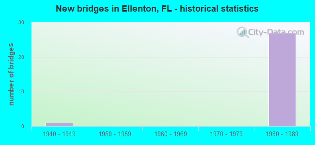
- New bridges - historical statistics
- 11940-1949
- 271980-1989

- Reconstructed bridges - Historical Statistics
- 11970-1979
- 01980-1989
- 21990-1999
- 12000-2009
- 12010-2019


- Bridge Condition - Deck
- 14.3%Very good
- 57.1%Good
- 28.6%Satisfactory

- Bridge Condition - Superstructure
- 64.3%Good
- 35.7%Satisfactory

- Bridge Condition - Substructure
- 14.3%Very good
- 85.7%Good

- Bridge Condition - Channel
- 12.5%Excellent
- 12.5%Very good
- 62.5%Good
- 12.5%Satisfactory
Find on map >> Show street view
Structure Number: 130015, Location: 1.8 MI E OF US-41/US-19 (Lat: 27.521778, Lng: -82.532028), Route carried "on" structure: US 301, Year Built: 1945, Year Reconstructed: 1979, Status: Open, Structure Length: 0.78m (2.56ft), Average Daily Traffic: 33,500 (year 2020), Truck Traffic: 8%, Average Future Daily Traffic: 58,122 (year 2042), Design Load: H 10, Features Intersected: MANAVISTA CREEK
Minimum Vertical Clearance: 30+ m (98+ ft), Kilometerpoint: 4.052, Lanes on structure: 4, Base Highway Network: Yes, Owner: State Highway Agency, Approaching Roadway Width: 16.6m (54.5ft), Skew: 29 degrees, Material/Design: Concrete, Design/Construction: Culvert, Number Of Spans In Main Unit: 2, Length of Maximum Span: 3.0m (9.8ft)
Condition: Channel: Good, Culverts: Good, Operating Rating: 53.4 metric tons, Method Used To Determine Operating Rating: Load Factor (LF), Inventory Rating: 32.1 metric tons, Method Used To Determine Inventory Rating: Load Factor (LF), Structural Evaluation: Better than present minimum criteria, Waterway Adequacy: Equal to present desirable criteria, Approach Roadway Alignment: Equal to present desirable criteria, Designated Inspection Frequency: Every 24 months, Inspection Date: October 2021
Find on map >> Show street view
Structure Number: 130063, Location: 2.0MI. S OF 97TH ST. EAST (Lat: 27.579822, Lng: -82.513367), Route carried "on" structure: County highway , Year Built: 1980, Status: Posted for load-capacity, Structure Length: 2.56m (8.40ft), Average Daily Traffic: 3,771 (year 2018), Truck Traffic: 7%, Average Future Daily Traffic: 6,543 (year 2040), Design Load: HS 20, Features Intersected: BUFFALO CANAL, Facility Carried by Structure: BUFFALO ROAD
Minimum Vertical Clearance: 30+ m (98+ ft), Kilometerpoint: 0.760, Lanes on structure: 2, Owner: County Highway Agency, Approaching Roadway Width: 7.9m (25.9ft), Material/Design: Concrete continuous, Design/Construction: Slab, Number Of Spans In Main Unit: 3, Length of Maximum Span: 8.5m (27.9ft), Curb or Sidewalk Widths: Left: 0.0m, Right: 1.5m (4.9ft), Curb-To-Curb Width: 7.9m (25.9ft), Out-to-Out Width: 10.5m (34.4ft)
Condition: Deck: Good, Superstructure: Good, Substructure: Good, Channel: Very good, Operating Rating: 58.3 metric tons, Method Used To Determine Operating Rating: Load Factor (LF), Inventory Rating: 34.9 metric tons, Method Used To Determine Inventory Rating: Load Factor (LF), Structural Evaluation: Better than present minimum criteria, Deck Geometry: High priority of corrective action, Waterway Adequacy: Better than present minimum criteria, Approach Roadway Alignment: Equal to present desirable criteria, Designated Inspection Frequency: Every 24 months, Inspection Date: March 2020, Deck Structure Type: Concrete Cast-file-Place
Find on map >> Show street view
Structure Number: 130075, Location: 2.0 MI NORTH OF US-301 (Lat: 27.556258, Lng: -82.512039), Route carried "on" structure: Interstate 75, Year Built: 1981, Year Reconstructed: 2004, Status: Open, Structure Length: 5.24m (17.19ft), Average Daily Traffic: 42,750 (year 2020), Truck Traffic: 12%, Average Future Daily Traffic: 74,171 (year 2042), Design Load: HS 20, Features Intersected: CSX R/R
Minimum Vertical Clearance: 30+ m (98+ ft), Kilometerpoint: 20.691, Lanes on structure: 3, Base Highway Network: Yes, Owner: State Highway Agency, Approaching Roadway Width: 17.4m (57.1ft), Skew: 1 degrees, Material/Design: Prestressed concrete, Design/Construction: Stringer/Multi-beam, Number Of Spans In Main Unit: 3, Length of Maximum Span: 24.1m (79.1ft), Curb-To-Curb Width: 17.0m (55.8ft), Out-to-Out Width: 17.9m (58.7ft)
Condition: Deck: Very good, Superstructure: Good, Substructure: Good, Operating Rating: 58.5 metric tons, Method Used To Determine Operating Rating: Load Factor (LF), Inventory Rating: 35.5 metric tons, Method Used To Determine Inventory Rating: Load Factor (LF), Structural Evaluation: Better than present minimum criteria, Deck Geometry: Equal to present minimum criteria, Underclear: Superior to present desirable criteria, Approach Roadway Alignment: Equal to present desirable criteria, Designated Inspection Frequency: Every 24 months, Inspection Date: November 2021, Deck Structure Type: Concrete Cast-file-Place
Find on map >> Show street view
Structure Number: 130076, Location: 2.0 MI NORTH OF US-301 (Lat: 27.556553, Lng: -82.511297), Route carried "on" structure: Interstate 75, Year Built: 1981, Year Reconstructed: 2004, Status: Open, Structure Length: 5.24m (17.19ft), Average Daily Traffic: 42,750 (year 2020), Truck Traffic: 12%, Average Future Daily Traffic: 74,171 (year 2042), Design Load: HS 20+Mod, Features Intersected: CSX RAILROAD
Minimum Vertical Clearance: 30+ m (98+ ft), Kilometerpoint: 20.711, Lanes on structure: 3, Base Highway Network: Yes (Inventory Route: 130750, Subroute: 40), Owner: State Highway Agency, Approaching Roadway Width: 17.4m (57.1ft), Skew: 1 degrees, Material/Design: Prestressed concrete, Design/Construction: Stringer/Multi-beam, Number Of Spans In Main Unit: 3, Length of Maximum Span: 24.7m (81.0ft), Curb-To-Curb Width: 17.0m (55.8ft), Out-to-Out Width: 17.9m (58.7ft)
Condition: Deck: Good, Superstructure: Good, Substructure: Good, Operating Rating: 56.1 metric tons, Method Used To Determine Operating Rating: Load Factor (LF), Inventory Rating: 34.0 metric tons, Method Used To Determine Inventory Rating: Load Factor (LF), Structural Evaluation: Better than present minimum criteria, Deck Geometry: Equal to present minimum criteria, Underclear: Superior to present desirable criteria, Approach Roadway Alignment: Equal to present desirable criteria, Designated Inspection Frequency: Every 24 months, Inspection Date: November 2021, Deck Structure Type: Concrete Cast-file-Place
Find on map >> Show street view
Structure Number: 130089, Location: 0.25 MI S OF I-275 (Lat: 27.574408, Lng: -82.514581), Route carried "on" structure: County highway , Year Built: 1980, Status: Open, Structure Length: 10.49m (34.42ft), Average Daily Traffic: 9,300 (year 2020), Truck Traffic: 6%, Average Future Daily Traffic: 16,136 (year 2042), Design Load: HS 20+Mod, Features Intersected: I-75, Facility Carried by Structure: ERIE ROAD
Minimum Vertical Clearance: 30+ m (98+ ft), Kilometerpoint: 2.781, Lanes on structure: 2, Lanes under structure: 9, Owner: State Highway Agency, Approaching Roadway Width: 10.9m (35.8ft), Skew: 2 degrees, Material/Design: Steel continuous, Design/Construction: Stringer/Multi-beam, Number Of Spans In Main Unit: 2, Length of Maximum Span: 52.4m (171.9ft), Curb-To-Curb Width: 12.2m (40.0ft), Out-to-Out Width: 13.1m (43.0ft)
Condition: Deck: Good, Superstructure: Good, Substructure: Good, Operating Rating: 87.4 metric tons, Method Used To Determine Operating Rating: Load Factor (LF), Inventory Rating: 52.3 metric tons, Method Used To Determine Inventory Rating: Load Factor (LF), Structural Evaluation: Better than present minimum criteria, Deck Geometry: Somewhat better than minimum adequacy, Underclear: Somewhat better than minimum adequacy, Approach Roadway Alignment: Equal to present desirable criteria, Designated Inspection Frequency: Every 24 months, Inspection Date: August 2021, Deck Structure Type: Concrete Precast Panels, Wearing Surface/Protective System: Wearing Surface: Integral Concrete
Find on map >> Show street view
Structure Number: 13009, Location: 3 MI NORTH OF US-301 (Lat: 27.583450, Lng: -82.514656), Route carried "on" structure: Interstate 275, Year Built: 1981, Year Reconstructed: 2009, Status: Open, Structure Length: 21.59m (70.83ft), Average Daily Traffic: 17,000 (year 2020), Truck Traffic: 7%, Average Future Daily Traffic: 29,495 (year 2042), Design Load: HL 93, Features Intersected: I-75
Minimum Vertical Clearance: 30+ m (98+ ft), Kilometerpoint: 0.896, Lanes on structure: 2, Lanes under structure: 6, Base Highway Network: Yes, Owner: State Highway Agency, Approaching Roadway Width: 12.3m (40.4ft), Material/Design: Steel continuous, Design/Construction: Stringer/Multi-beam, Number Of Spans In Main Unit: 4, Length of Maximum Span: 74.0m (242.8ft), Curb-To-Curb Width: 12.3m (40.4ft), Out-to-Out Width: 13.1m (43.0ft)
Condition: Deck: Good, Superstructure: Good, Substructure: Good, Operating Rating: 49.9 metric tons, Method Used To Determine Operating Rating: Load and Resistance Factor (LRFR), Inventory Rating: 38.1 metric tons, Method Used To Determine Inventory Rating: Load and Resistance Factor (LRFR), Structural Evaluation: Better than present minimum criteria, Deck Geometry: Better than present minimum criteria, Underclear: Equal to present minimum criteria, Approach Roadway Alignment: Equal to present desirable criteria, Designated Inspection Frequency: Every 24 months, Inspection Date: August 2021, Deck Structure Type: Concrete Cast-file-Place
Find on map >> Show street view
Structure Number: 130103, Location: 3.5 MI NORTH OF SR-64 (Lat: 27.525294, Lng: -82.506558), Route carried "on" structure: Interstate 75, Year Built: 1980, Status: Open, Structure Length: 116.58m (382.48ft), Average Daily Traffic: 52,000 (year 2020), Truck Traffic: 14%, Average Future Daily Traffic: 90,220 (year 2042), Design Load: HS 20, Features Intersected: US-301/MANATEE RIVER
Minimum Vertical Clearance: 30+ m (98+ ft), Kilometerpoint: 16.599, Lanes on structure: 3, Lanes under structure: 11, Base Highway Network: Yes, Owner: State Highway Agency, Approaching Roadway Width: 17.0m (55.8ft), Navigation Control: Yes ( Vertical Clearance: 12.4m (40.7ft), Horizontal Clearance: 22.0m (72.2ft)), Material/Design: Prestressed concrete, Design/Construction: Stringer/Multi-beam, Number Of Spans In Main Unit: 41, Length of Maximum Span: 33.5m (109.9ft), Curb-To-Curb Width: 17.0m (55.8ft), Out-to-Out Width: 17.8m (58.4ft)
Condition: Deck: Satisfactory, Superstructure: Satisfactory, Substructure: Good, Channel: Excellent, Operating Rating: 65.3 metric tons, Method Used To Determine Operating Rating: Load Factor (LF), Inventory Rating: 39.0 metric tons, Method Used To Determine Inventory Rating: Load Factor (LF), Structural Evaluation: Equal to present minimum criteria, Deck Geometry: Equal to present minimum criteria, Underclear: Better than present minimum criteria, Waterway Adequacy: Equal to present desirable criteria, Approach Roadway Alignment: Equal to present desirable criteria, Designated Inspection Frequency: Every 24 months, Underwater Inspection Frequency: Every 24 months, Inspection Date: November 2021, Underwater Inspection Date: October 2021, Deck Structure Type: Concrete Cast-file-Place
Find on map >> Show street view
Structure Number: 130104, Location: 3.5 MI NORTH OF SR-64 (Lat: 27.525408, Lng: -82.506175), Route carried "on" structure: Interstate 75, Year Built: 1980, Status: Open, Structure Length: 116.58m (382.48ft), Average Daily Traffic: 52,000 (year 2020), Truck Traffic: 14%, Average Future Daily Traffic: 90,220 (year 2042), Design Load: HS 20, Features Intersected: US-301/ MANATEE RIVER
Minimum Vertical Clearance: 30+ m (98+ ft), Kilometerpoint: 16.599, Lanes on structure: 3, Lanes under structure: 11, Base Highway Network: Yes, Owner: State Highway Agency, Approaching Roadway Width: 17.0m (55.8ft), Navigation Control: Yes ( Vertical Clearance: 12.2m (40.0ft), Horizontal Clearance: 23.2m (76.1ft)), Material/Design: Prestressed concrete, Design/Construction: Stringer/Multi-beam, Number Of Spans In Main Unit: 41, Length of Maximum Span: 33.5m (109.9ft), Curb-To-Curb Width: 17.0m (55.8ft), Out-to-Out Width: 17.8m (58.4ft)
Condition: Deck: Satisfactory, Superstructure: Satisfactory, Substructure: Good, Channel: Good, Operating Rating: 65.3 metric tons, Method Used To Determine Operating Rating: Load Factor (LF), Inventory Rating: 39.0 metric tons, Method Used To Determine Inventory Rating: Load Factor (LF), Structural Evaluation: Equal to present minimum criteria, Deck Geometry: Equal to present minimum criteria, Underclear: Better than present minimum criteria, Waterway Adequacy: Equal to present desirable criteria, Approach Roadway Alignment: Equal to present desirable criteria, Designated Inspection Frequency: Every 24 months, Underwater Inspection Frequency: Every 24 months, Inspection Date: November 2021, Underwater Inspection Date: October 2021, Deck Structure Type: Concrete Cast-file-Place
Find on map >> Show street view
Structure Number: 130107, Location: 2.0 MI S OF I-275 (Lat: 27.546861, Lng: -82.510894), Route carried "on" structure: County highway , Year Built: 1980, Status: Open, Structure Length: 8.66m (28.41ft), Average Daily Traffic: 7,000 (year 2020), Truck Traffic: 4%, Average Future Daily Traffic: 12,145 (year 2042), Design Load: HS 20, Features Intersected: I-75 (SR-93), Facility Carried by Structure: MENDOZA RD (37TH)
Minimum Vertical Clearance: 30+ m (98+ ft), Kilometerpoint: 1.674, Lanes on structure: 2, Lanes under structure: 6, Owner: State Highway Agency, Approaching Roadway Width: 12.1m (39.7ft), Material/Design: Prestressed concrete, Design/Construction: Stringer/Multi-beam, Number Of Spans In Main Unit: 4, Length of Maximum Span: 34.1m (111.9ft), Curb-To-Curb Width: 12.1m (39.7ft), Out-to-Out Width: 13.3m (43.6ft)
Condition: Deck: Good, Superstructure: Good, Substructure: Very good, Operating Rating: 52.6 metric tons, Method Used To Determine Operating Rating: Allowable Stress (AS), Inventory Rating: 43.5 metric tons, Method Used To Determine Inventory Rating: Allowable Stress (AS), Structural Evaluation: Better than present minimum criteria, Deck Geometry: Somewhat better than minimum adequacy, Underclear: Somewhat better than minimum adequacy, Approach Roadway Alignment: Equal to present desirable criteria, Designated Inspection Frequency: Every 24 months, Inspection Date: August 2021, Deck Structure Type: Concrete Precast Panels
Find on map >> Show street view
Structure Number: 130108, Location: 800FT. SOUTH OF I-275 (Lat: 27.580025, Lng: -82.514936), Route carried "on" structure: Interstate 75, Year Built: 1981, Status: Open, Structure Length: 3.35m (10.99ft), Average Daily Traffic: 42,750 (year 2020), Truck Traffic: 12%, Average Future Daily Traffic: 74,171 (year 2042), Design Load: HS 20+Mod, Features Intersected: BUFFALO CANAL
Minimum Vertical Clearance: 30+ m (98+ ft), Kilometerpoint: 23.352, Lanes on structure: 5, Base Highway Network: Yes, Owner: State Highway Agency, Approaching Roadway Width: 25.2m (82.7ft), Skew: 1 degrees, Material/Design: Concrete continuous, Design/Construction: Slab, Number Of Spans In Main Unit: 4, Length of Maximum Span: 9.3m (30.5ft), Curb-To-Curb Width: 25.2m (82.7ft), Out-to-Out Width: 26.2m (86.0ft)
Condition: Deck: Satisfactory, Superstructure: Satisfactory, Substructure: Good, Channel: Good, Operating Rating: 60.2 metric tons, Method Used To Determine Operating Rating: Load Factor (LF), Inventory Rating: 36.0 metric tons, Method Used To Determine Inventory Rating: Load Factor (LF), Structural Evaluation: Equal to present minimum criteria, Deck Geometry: Better than present minimum criteria, Waterway Adequacy: Equal to present desirable criteria, Approach Roadway Alignment: Equal to present desirable criteria, Designated Inspection Frequency: Every 24 months, Inspection Date: April 2021, Deck Structure Type: Concrete Cast-file-Place
Find on map >> Show street view
Structure Number: 130109, Location: 800FT. SOUTH OF I-275 (Lat: 27.579908, Lng: -82.514456), Route carried "on" structure: Interstate 75, Year Built: 1981, Status: Open, Structure Length: 3.35m (10.99ft), Average Daily Traffic: 42,750 (year 2020), Truck Traffic: 12%, Average Future Daily Traffic: 74,171 (year 2042), Design Load: HS 20+Mod, Features Intersected: BUFFALO CANAL
Minimum Vertical Clearance: 30+ m (98+ ft), Kilometerpoint: 23.342, Lanes on structure: 3, Base Highway Network: Yes, Owner: State Highway Agency, Approaching Roadway Width: 17.0m (55.8ft), Skew: 1 degrees, Material/Design: Concrete continuous, Design/Construction: Slab, Number Of Spans In Main Unit: 4, Length of Maximum Span: 9.1m (29.9ft), Curb-To-Curb Width: 17.0m (55.8ft), Out-to-Out Width: 17.9m (58.7ft)
Condition: Deck: Satisfactory, Superstructure: Satisfactory, Substructure: Good, Channel: Good, Operating Rating: 62.5 metric tons, Method Used To Determine Operating Rating: Load Factor (LF), Inventory Rating: 37.4 metric tons, Method Used To Determine Inventory Rating: Load Factor (LF), Structural Evaluation: Equal to present minimum criteria, Deck Geometry: Equal to present minimum criteria, Waterway Adequacy: Equal to present desirable criteria, Approach Roadway Alignment: Equal to present desirable criteria, Designated Inspection Frequency: Every 24 months, Inspection Date: April 2021, Deck Structure Type: Concrete Cast-file-Place
Find on map >> Show street view
Structure Number: 13011, Location: 800FT. SOUTH OF I-275 (Lat: 27.579861, Lng: -82.513917), Route carried "on" structure: Ramp Interstate 275, Year Built: 1981, Status: Open, Structure Length: 3.90m (12.80ft), Average Daily Traffic: 17,000 (year 2020), Truck Traffic: 7%, Average Future Daily Traffic: 29,495 (year 2042), Design Load: HS 20+Mod, Features Intersected: BUFFALO CANAL
Minimum Vertical Clearance: 30+ m (98+ ft), Kilometerpoint: 0.612, Lanes on structure: 2, Owner: State Highway Agency, Approaching Roadway Width: 12.1m (39.7ft), Material/Design: Prestressed concrete, Design/Construction: Stringer/Multi-beam, Number Of Spans In Main Unit: 2, Length of Maximum Span: 20.4m (66.9ft), Curb-To-Curb Width: 12.1m (39.7ft), Out-to-Out Width: 12.9m (42.3ft)
Condition: Deck: Good, Superstructure: Good, Substructure: Good, Channel: Good, Operating Rating: 48.6 metric tons, Method Used To Determine Operating Rating: Load and Resistance Factor (LRFR), Inventory Rating: 37.9 metric tons, Method Used To Determine Inventory Rating: Load and Resistance Factor (LRFR), Structural Evaluation: Better than present minimum criteria, Deck Geometry: Superior to present desirable criteria, Waterway Adequacy: Equal to present desirable criteria, Approach Roadway Alignment: Equal to present desirable criteria, Designated Inspection Frequency: Every 24 months, Inspection Date: April 2021, Deck Structure Type: Concrete Precast Panels
Find on map >> Show street view
Structure Number: 130112, Location: 0.6 MI EAST OF US-41 (Lat: 27.585383, Lng: -82.515619), Route carried "on" structure: Ramp Interstate 275, Year Built: 1981, Year Reconstructed: 2019, Status: Open, Structure Length: 68.55m (224.90ft), Average Daily Traffic: 9,100 (year 2020), Truck Traffic: 7%, Average Future Daily Traffic: 15,788 (year 2042), Design Load: HS 20+Mod, Features Intersected: I-75 AND I-275 RAMPS
Minimum Vertical Clearance: 30+ m (98+ ft), Kilometerpoint: 0.587, Lanes on structure: 1, Lanes under structure: 10, Owner: State Highway Agency, Approaching Roadway Width: 10.9m (35.8ft), Skew: 9 degrees, Material/Design: Steel continuous, Design/Construction: Stringer/Multi-beam, Number Of Spans In Main Unit: 6, Number Of Approach Spans: 13, Length of Maximum Span: 76.5m (251.0ft), Curb-To-Curb Width: 10.9m (35.8ft), Out-to-Out Width: 11.7m (38.4ft)
Condition: Deck: Very good, Superstructure: Good, Substructure: Good, Operating Rating: 37.6 metric tons, Method Used To Determine Operating Rating: Load and Resistance Factor (LRFR), Inventory Rating: 33.9 metric tons, Method Used To Determine Inventory Rating: Load and Resistance Factor (LRFR), Structural Evaluation: Better than present minimum criteria, Deck Geometry: Superior to present desirable criteria, Underclear: Meets minimum limits, Approach Roadway Alignment: Equal to present desirable criteria, Length Of Structure Improvement: 68.60m (225.07ft), Designated Inspection Frequency: Every 24 months, Inspection Date: November 2021, Bridge Improvement Cost: $92,000, Roadway Improvement Cost: $5,000, Total Project Cost: $97,000, Deck Structure Type: Concrete Precast Panels
Find on map >> Show street view
Structure Number: 130122, Location: 1.0MI EAST OF US-41 (Lat: 27.585689, Lng: -82.527336), Route carried "on" structure: County highway 683, Year Built: 1983, Status: Open, Structure Length: 8.87m (29.10ft), Average Daily Traffic: 7,000 (year 2020), Truck Traffic: 8%, Average Future Daily Traffic: 12,145 (year 2042), Design Load: HS 20+Mod, Features Intersected: I-275/SR-93
Minimum Vertical Clearance: 30+ m (98+ ft), Kilometerpoint: 7.010, Lanes on structure: 2, Lanes under structure: 5, Owner: State Highway Agency, Approaching Roadway Width: 12.3m (40.4ft), Material/Design: Steel continuous, Design/Construction: Stringer/Multi-beam, Number Of Spans In Main Unit: 2, Length of Maximum Span: 46.0m (150.9ft), Curb-To-Curb Width: 12.3m (40.4ft), Out-to-Out Width: 13.0m (42.7ft)
Condition: Deck: Good, Superstructure: Satisfactory, Substructure: Good, Operating Rating: 60.8 metric tons, Method Used To Determine Operating Rating: Load Factor (LF), Inventory Rating: 36.3 metric tons, Method Used To Determine Inventory Rating: Load Factor (LF), Structural Evaluation: Equal to present minimum criteria, Deck Geometry: Somewhat better than minimum adequacy, Underclear: Somewhat better than minimum adequacy, Approach Roadway Alignment: Equal to present desirable criteria, Length Of Structure Improvement: 8.90m (29.20ft), Designated Inspection Frequency: Every 24 months, Inspection Date: August 2020, Bridge Improvement Cost: $75,000, Roadway Improvement Cost: $5,000, Total Project Cost: $80,000, Deck Structure Type: Concrete Cast-file-Place
Find on map >> Show street view
Structure Number: 130131, Location: 1.4MI S/O MOCCASIN WALLOW (Lat: 27.580769, Lng: -82.527375), Route carried "on" structure: County highway 683, Year Built: 1984, Status: Open, Structure Length: 2.74m (8.99ft), Average Daily Traffic: 11,587 (year 2018), Truck Traffic: 6%, Average Future Daily Traffic: 20,103 (year 2040), Design Load: HS 20, Features Intersected: BUFFALO CANAL
Minimum Vertical Clearance: 30+ m (98+ ft), Kilometerpoint: 6.500, Lanes on structure: 2, Owner: County Highway Agency, Approaching Roadway Width: 12.3m (40.4ft), Skew: 1 degrees, Material/Design: Prestressed concrete, Design/Construction: Slab, Number Of Spans In Main Unit: 3, Length of Maximum Span: 9.1m (29.9ft), Curb-To-Curb Width: 12.3m (40.4ft), Out-to-Out Width: 13.2m (43.3ft)
Condition: Deck: Good, Superstructure: Good, Substructure: Very good, Channel: Satisfactory, Operating Rating: 63.5 metric tons, Method Used To Determine Operating Rating: Allowable Stress (AS), Inventory Rating: 49.9 metric tons, Method Used To Determine Inventory Rating: Allowable Stress (AS), Structural Evaluation: Better than present minimum criteria, Deck Geometry: Somewhat better than minimum adequacy, Waterway Adequacy: Equal to present desirable criteria, Approach Roadway Alignment: Equal to present desirable criteria, Designated Inspection Frequency: Every 24 months, Inspection Date: March 2020, Deck Structure Type: Concrete Cast-file-Place, Wearing Surface/Protective System: Wearing Surface: Bituminous
Find on map >> Show street view
Structure Number: 130089, Location: 0.25 MI S OF I-275 (Lat: 27.574408, Lng: -82.514581), Route carried "under" structure: Interstate 75, Year Built: 1980, Structure Length: 0. m, Average Daily Traffic: 85,500 (year 2020), Truck Traffic: 12%, Features Intersected: I-75, Facility Carried by Structure: ERIE ROAD
Minimum Vertical Clearance: 4.88m (16.01ft), Kilometerpoint: 22.735, Lanes on structure: 2, Lanes under structure: 9, Material/Design: Steel continuous, Design/Construction: Stringer/Multi-beam, Length of Maximum Span: 52.4m (171.9ft)
Find on map >> Show street view
Structure Number: 13009, Location: 3 MI NORTH OF US-301 (Lat: 27.583450, Lng: -82.514656), Route carried "under" structure: Interstate 75, Year Built: 1981, Structure Length: 0. m, Average Daily Traffic: 58,000 (year 2020), Truck Traffic: 18%, Features Intersected: I-75
Minimum Vertical Clearance: 5.09m (16.70ft), Kilometerpoint: 23.749, Lanes on structure: 2, Lanes under structure: 6, Material/Design: Steel continuous, Design/Construction: Stringer/Multi-beam, Length of Maximum Span: 74.0m (242.8ft)
Find on map >> Show street view
Structure Number: 130103, Location: 3.5 MI NORTH OF SR-64 (Lat: 27.525294, Lng: -82.506558), Route carried "under" structure: Other road , Year Built: 1980, Structure Length: 0. m, Average Daily Traffic: 101 (year 2021), Truck Traffic: 1%, Features Intersected: US-301/MANATEE RIVER, Facility Carried by Structure: I-75 SB (SR-93)
Minimum Vertical Clearance: 5.06m (16.60ft), Kilometerpoint: 0.000, Lanes on structure: 3, Lanes under structure: 2, Material/Design: Prestressed concrete, Design/Construction: Stringer/Multi-beam, Length of Maximum Span: 33.5m (109.9ft)
Find on map >> Show street view
Structure Number: 130103, Location: 3.5 MI NORTH OF SR-64 (Lat: 27.525294, Lng: -82.506558), Route carried "under" structure: City street , Year Built: 1980, Structure Length: 0. m, Average Daily Traffic: 1,440 (year 2021), Truck Traffic: 2%, Features Intersected: US-301/MANATEE RIVER, Facility Carried by Structure: I-75 SB (SR-93)
Minimum Vertical Clearance: 5.73m (18.80ft), Kilometerpoint: 0.000, Lanes on structure: 3, Lanes under structure: 2, Material/Design: Prestressed concrete, Design/Construction: Stringer/Multi-beam, Length of Maximum Span: 33.5m (109.9ft)
Find on map >> Show street view
Structure Number: 130103, Location: 3.5 MI NORTH OF SR-64 (Lat: 27.525294, Lng: -82.506558), Route carried "under" structure: US 301, Year Built: 1980, Structure Length: 0. m, Average Daily Traffic: 37,000 (year 2020), Truck Traffic: 8%, Features Intersected: US-301/MANATEE RIVER, Facility Carried by Structure: I-75 SB (SR-93)
Minimum Vertical Clearance: 4.88m (16.01ft), Kilometerpoint: 6.759, Lanes on structure: 3, Lanes under structure: 7, Material/Design: Prestressed concrete, Design/Construction: Stringer/Multi-beam, Length of Maximum Span: 33.5m (109.9ft)
Find on map >> Show street view
Structure Number: 130104, Location: 3.5 MI NORTH OF SR-64 (Lat: 27.525408, Lng: -82.506175), Route carried "under" structure: Other road , Year Built: 1980, Structure Length: 0. m, Average Daily Traffic: 101 (year 2021), Truck Traffic: 1%, Features Intersected: US-301/ MANATEE RIVER, Facility Carried by Structure: I-75 NB (SR-93)
Minimum Vertical Clearance: 5.09m (16.70ft), Kilometerpoint: 0.000, Lanes on structure: 3, Lanes under structure: 2, Material/Design: Prestressed concrete, Design/Construction: Stringer/Multi-beam, Length of Maximum Span: 33.5m (109.9ft)
Find on map >> Show street view
Structure Number: 130104, Location: 3.5 MI NORTH OF SR-64 (Lat: 27.525408, Lng: -82.506175), Route carried "under" structure: City street , Year Built: 1980, Structure Length: 0. m, Average Daily Traffic: 1,440 (year 2021), Truck Traffic: 2%, Features Intersected: US-301/ MANATEE RIVER, Facility Carried by Structure: I-75 NB (SR-93)
Minimum Vertical Clearance: 5.73m (18.80ft), Kilometerpoint: 0.000, Lanes on structure: 3, Lanes under structure: 2, Material/Design: Prestressed concrete, Design/Construction: Stringer/Multi-beam, Length of Maximum Span: 33.5m (109.9ft)
Find on map >> Show street view
Structure Number: 130104, Location: 3.5 MI NORTH OF SR-64 (Lat: 27.525408, Lng: -82.506175), Route carried "under" structure: US 301, Year Built: 1980, Structure Length: 0. m, Average Daily Traffic: 37,000 (year 2020), Truck Traffic: 8%, Features Intersected: US-301/ MANATEE RIVER, Facility Carried by Structure: I-75 NB (SR-93)
Minimum Vertical Clearance: 5.00m (16.40ft), Kilometerpoint: 6.799, Lanes on structure: 3, Lanes under structure: 7, Material/Design: Prestressed concrete, Design/Construction: Stringer/Multi-beam, Length of Maximum Span: 33.5m (109.9ft)
Find on map >> Show street view
Structure Number: 130107, Location: 2.0 MI S OF I-275 (Lat: 27.546861, Lng: -82.510894), Route carried "under" structure: Interstate 75, Year Built: 1980, Structure Length: 0. m, Average Daily Traffic: 85,500 (year 2020), Truck Traffic: 12%, Features Intersected: I-75 (SR-93), Facility Carried by Structure: MENDOZA RD (37TH)
Minimum Vertical Clearance: 5.00m (16.40ft), Kilometerpoint: 19.657, Lanes on structure: 2, Lanes under structure: 6, Material/Design: Prestressed concrete, Design/Construction: Stringer/Multi-beam, Length of Maximum Span: 34.1m (111.9ft)
Find on map >> Show street view
Structure Number: 130112, Location: 0.6 MI EAST OF US-41 (Lat: 27.585383, Lng: -82.515619), Route carried "under" structure: Ramp Interstate 275, Year Built: 1981, Structure Length: 0. m, Average Daily Traffic: 18,000 (year 2020), Truck Traffic: 7%, Features Intersected: I-75 AND I-275 RAMPS
Minimum Vertical Clearance: 10.97m (35.99ft), Kilometerpoint: 0.694, Lanes on structure: 1, Lanes under structure: 2, Material/Design: Steel continuous, Design/Construction: Stringer/Multi-beam, Length of Maximum Span: 76.5m (251.0ft)
Find on map >> Show street view
Structure Number: 130112, Location: 0.6 MI EAST OF US-41 (Lat: 27.585383, Lng: -82.515619), Route carried "under" structure: Interstate 75, Year Built: 1981, Structure Length: 0. m, Average Daily Traffic: 58,000 (year 2020), Truck Traffic: 18%, Features Intersected: I-75 AND I-275 RAMPS
Minimum Vertical Clearance: 7.25m (23.79ft), Kilometerpoint: 24.032, Lanes on structure: 1, Lanes under structure: 6, Material/Design: Steel continuous, Design/Construction: Stringer/Multi-beam, Length of Maximum Span: 76.5m (251.0ft)
Find on map >> Show street view
Structure Number: 130112, Location: 0.6 MI EAST OF US-41 (Lat: 27.585383, Lng: -82.515619), Route carried "under" structure: Ramp Interstate 275, Year Built: 1981, Structure Length: 0. m, Average Daily Traffic: 17,000 (year 2020), Truck Traffic: 7%, Features Intersected: I-75 AND I-275 RAMPS
Minimum Vertical Clearance: 4.97m (16.31ft), Kilometerpoint: 1.281, Lanes on structure: 1, Lanes under structure: 2, Material/Design: Steel continuous, Design/Construction: Stringer/Multi-beam, Length of Maximum Span: 76.5m (251.0ft)
Find on map >> Show street view
Structure Number: 130122, Location: 1.0MI EAST OF US-41 (Lat: 27.585689, Lng: -82.527336), Route carried "under" structure: Interstate 275, Year Built: 1983, Structure Length: 0. m, Average Daily Traffic: 54,000 (year 2020), Truck Traffic: 9%, Features Intersected: I-275/SR-93, Facility Carried by Structure: CR-683
Minimum Vertical Clearance: 4.91m (16.11ft), Kilometerpoint: 2.382, Lanes on structure: 2, Lanes under structure: 5, Material/Design: Steel continuous, Design/Construction: Stringer/Multi-beam, Length of Maximum Span: 46.0m (150.9ft)