Bridge Statistics for Elkview, West Virginia (WV)
Condition, Traffic, Stress, Structural Evaluation, Project Costs
- National Bridge Inventory (NBI) Statistics
- 31Number of bridges
- 374ft / 114mTotal length
- $8,450,000Total costs
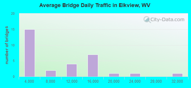
- 233,211Total average daily traffic
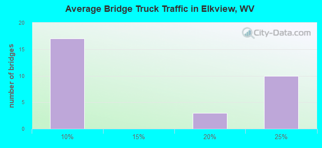
- 40,742Total average daily truck traffic
- National Bridge Inventory (NBI) Registered Bridges for Elkview
- No street view available for this location
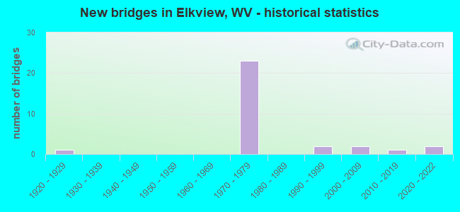
- New bridges - historical statistics
- 11920-1929
- 231970-1979
- 21990-1999
- 22000-2009
- 12010-2019
- 22020-2022
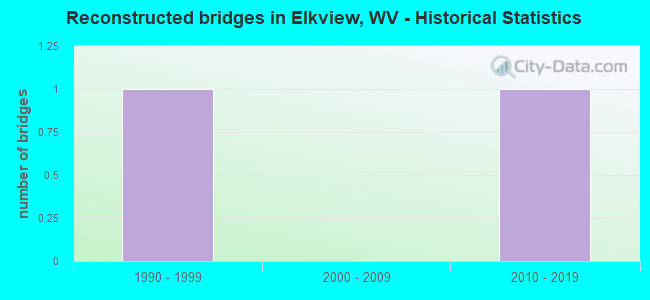
- Reconstructed bridges - Historical Statistics
- 11990-1999
- 02000-2009
- 12010-2019
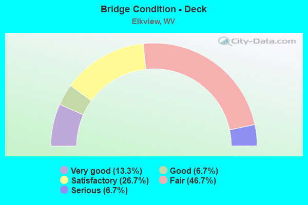
- Bridge Condition - Deck
- 13.3%Very good
- 6.7%Good
- 26.7%Satisfactory
- 46.7%Fair
- 6.7%Serious
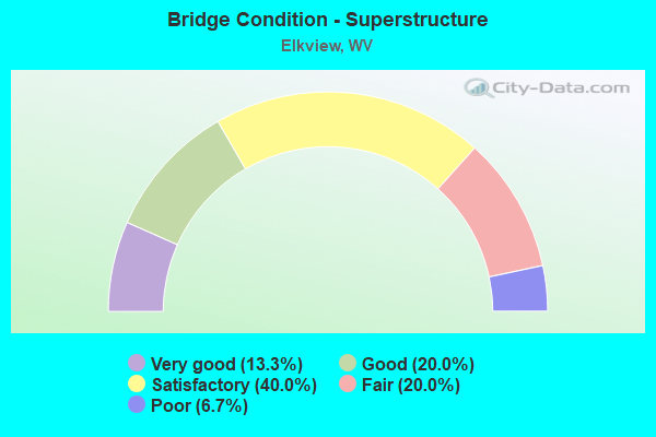
- Bridge Condition - Superstructure
- 13.3%Very good
- 20.0%Good
- 40.0%Satisfactory
- 20.0%Fair
- 6.7%Poor
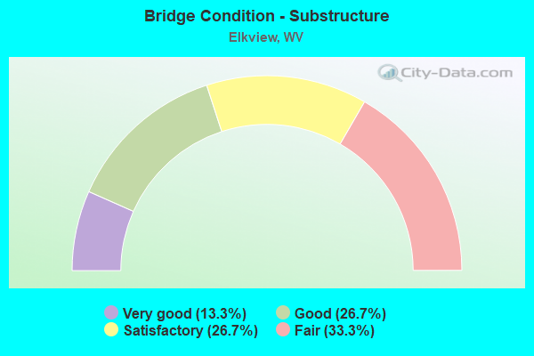
- Bridge Condition - Substructure
- 13.3%Very good
- 26.7%Good
- 26.7%Satisfactory
- 33.3%Fair
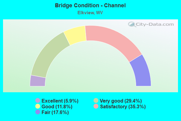
- Bridge Condition - Channel
- 5.9%Excellent
- 29.4%Very good
- 11.8%Good
- 35.3%Satisfactory
- 17.6%Fair
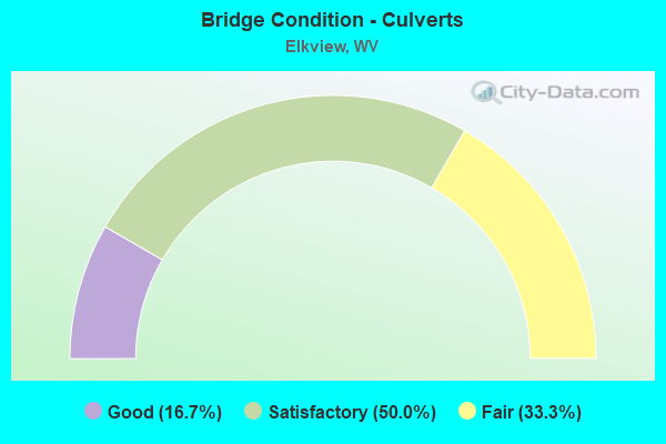
- Bridge Condition - Culverts
- 16.7%Good
- 50.0%Satisfactory
- 33.3%Fair
Find on map >> Show street view
Structure Number: 20A094, Location: 0.05 MI N OF CR 43 (Lat: 38.462861, Lng: -81.500119), Route carried "on" structure: County highway 39, Year Built: 1928, Year Reconstructed: 1997, Status: Posted for load, Structure Length: 3.80m (12.47ft), Average Daily Traffic: 950 (year 2020), Truck Traffic: 5%, Average Future Daily Traffic: 1,159 (year 2040), Features Intersected: LITTLE SANDY CREEK
Minimum Vertical Clearance: 4.75m (15.58ft), Kilometerpoint: 0.080, Lanes on structure: 2, Owner: State Highway Agency, Approaching Roadway Width: 4.9m (16.1ft), Material/Design: Steel, Design/Construction: Truss - Thru, Number Of Spans In Main Unit: 1, Length of Maximum Span: 36.6m (120.1ft), Curb-To-Curb Width: 4.9m (16.1ft), Out-to-Out Width: 5.2m (17.1ft)
Condition: Deck: Serious, Superstructure: Poor, Substructure: Fair, Channel: Fair, Operating Rating: 28.1 metric tons, Method Used To Determine Operating Rating: Load Factor (LF), Inventory Rating: 16.3 metric tons, Method Used To Determine Inventory Rating: Load Factor (LF), Structural Evaluation: Meets minimum limits, Deck Geometry: High priority of replacement, Waterway Adequacy: Equal to present minimum criteria, Approach Roadway Alignment: Equal to present minimum criteria, Bridge Posting: Required (Relationship of Operating Rating to Maximum Legal Load: > 39.9% below), Length Of Structure Improvement: 3.96m (12.99ft), Designated Inspection Frequency: Every 24 months, Critical Feature Inspection Frequency: Every 12 months, Inspection Date: May 2021, Critical Feature Inspection Date: May 2021, Bridge Improvement Cost: $1,000,000, Roadway Improvement Cost: $200,000, Total Project Cost: $1,200,000 ( Estimate for 2021), Deck Structure Type: Concrete Cast-file-Place, Wearing Surface/Protective System: Wearing Surface: Bituminous
Find on map >> Show street view
Structure Number: 20A107, Location: 1.39 MI N OF CR 45/2 (Lat: 38.447569, Lng: -81.507019), Route carried "on" structure: County highway 4500, Year Built: 1993, Status: Open, Structure Length: 3.69m (12.11ft), Average Daily Traffic: 700 (year 2019), Truck Traffic: 5%, Average Future Daily Traffic: 854 (year 2039), Design Load: HS 25 or greater, Features Intersected: LITTLE SANDY CK, Facility Carried by Structure: CR 45
Minimum Vertical Clearance: 30+ m (98+ ft), Kilometerpoint: 8.369, Lanes on structure: 2, Owner: State Highway Agency, Approaching Roadway Width: 4.6m (15.1ft), Material/Design: Prestressed concrete, Design/Construction: Box Beam or Girders - Multiple, Number Of Spans In Main Unit: 1, Number Of Approach Spans: 1, Length of Maximum Span: 19.5m (64.0ft), Curb-To-Curb Width: 7.0m (23.0ft), Out-to-Out Width: 7.4m (24.3ft)
Condition: Deck: Satisfactory, Superstructure: Satisfactory, Substructure: Very good, Channel: Satisfactory, Operating Rating: 88.9 metric tons, Method Used To Determine Operating Rating: Load Factor (LF), Inventory Rating: 60.8 metric tons, Method Used To Determine Inventory Rating: Load Factor (LF), Structural Evaluation: Equal to present minimum criteria, Deck Geometry: Meets minimum limits, Waterway Adequacy: Equal to present desirable criteria, Approach Roadway Alignment: Somewhat better than minimum adequacy, Designated Inspection Frequency: Every 24 months, Inspection Date: September 2020, Deck Structure Type: Other, Wearing Surface/Protective System: Wearing Surface: Bituminous, Deck Protection: Epoxy Coated Reinforcing
Find on map >> Show street view
Structure Number: 20A137, Location: 0.02 MI N OF CR 52 (Lat: 38.449200, Lng: -81.455931), Route carried "on" structure: County highway 5700, Year Built: 1993, Status: Open, Structure Length: 12.07m (39.60ft), Average Daily Traffic: 2,100 (year 2018), Truck Traffic: 6%, Average Future Daily Traffic: 2,562 (year 2039), Design Load: HS 25 or greater, Features Intersected: ELK RIVER, Facility Carried by Structure: CR 57
Minimum Vertical Clearance: 30+ m (98+ ft), Kilometerpoint: 38.898, Lanes on structure: 2, Owner: State Highway Agency, Approaching Roadway Width: 7.9m (25.9ft), Material/Design: Steel continuous, Design/Construction: Stringer/Multi-beam, Number Of Spans In Main Unit: 2, Number Of Approach Spans: 2, Length of Maximum Span: 34.4m (112.9ft), Curb or Sidewalk Widths: Left: 1.5m (4.9ft), Right: 0.0m, Curb-To-Curb Width: 8.5m (27.9ft), Out-to-Out Width: 10.1m (33.1ft)
Condition: Deck: Satisfactory, Superstructure: Good, Substructure: Good, Channel: Very good, Operating Rating: 59.0 metric tons, Method Used To Determine Operating Rating: Load Factor (LF), Inventory Rating: 35.4 metric tons, Method Used To Determine Inventory Rating: Load Factor (LF), Structural Evaluation: Better than present minimum criteria, Deck Geometry: Meets minimum limits, Waterway Adequacy: Superior to present desirable criteria, Approach Roadway Alignment: Equal to present desirable criteria, Designated Inspection Frequency: Every 24 months, Underwater Inspection Frequency: Every 60 months, Inspection Date: October 2020, Underwater Inspection Date: November 2018, Deck Structure Type: Concrete Cast-file-Place, Wearing Surface/Protective System: Wearing Surface: Monolithic Concrete, Deck Protection: Epoxy Coated Reinforcing
Find on map >> Show street view
Structure Number: 20A327, Location: 0.62 MI N OF CR 43/15 (Lat: 38.456069, Lng: -81.495131), Route carried "on" structure: County highway 43, Year Built: 1975, Status: Open, Structure Length: 6.90m (22.64ft), Average Daily Traffic: 6,000 (year 2020), Truck Traffic: 5%, Average Future Daily Traffic: 7,860 (year 2040), Design Load: HS 20+Mod, Features Intersected: I-79 NB & SB
Minimum Vertical Clearance: 30+ m (98+ ft), Kilometerpoint: 2.108, Lanes on structure: 3, Lanes under structure: 4, Owner: State Highway Agency, Approaching Roadway Width: 19.2m (63.0ft), Skew: 2 degrees, Material/Design: Steel continuous, Design/Construction: Stringer/Multi-beam, Number Of Spans In Main Unit: 2, Length of Maximum Span: 33.5m (109.9ft), Curb-To-Curb Width: 18.5m (60.7ft), Out-to-Out Width: 19.7m (64.6ft)
Condition: Deck: Fair, Superstructure: Satisfactory, Substructure: Satisfactory, Operating Rating: 78.0 metric tons, Method Used To Determine Operating Rating: Load Factor (LF), Inventory Rating: 49.9 metric tons, Method Used To Determine Inventory Rating: Load Factor (LF), Structural Evaluation: Equal to present minimum criteria, Deck Geometry: Superior to present desirable criteria, Underclear: Better than present minimum criteria, Approach Roadway Alignment: Equal to present desirable criteria, Length Of Structure Improvement: 6.90m (22.64ft), Designated Inspection Frequency: Every 24 months, Inspection Date: October 2021, Bridge Improvement Cost: $250,000, Roadway Improvement Cost: $50,000, Total Project Cost: $300,000 ( Estimate for 2019), Deck Structure Type: Concrete Cast-file-Place, Wearing Surface/Protective System: Wearing Surface: Latex Concrete
Find on map >> Show street view
Structure Number: 20A332, Location: 2.52 MI E OF CR 43 (Lat: 38.479150, Lng: -81.465639), Route carried "on" structure: County highway 5300, Year Built: 1976, Status: Open, Structure Length: 11.93m (39.14ft), Average Daily Traffic: 600 (year 2018), Truck Traffic: 5%, Average Future Daily Traffic: 732 (year 2039), Design Load: HS 20, Features Intersected: I-79 NB & SB, Facility Carried by Structure: CR 53
Minimum Vertical Clearance: 30+ m (98+ ft), Kilometerpoint: 4.056, Lanes on structure: 2, Lanes under structure: 4, Owner: State Highway Agency, Approaching Roadway Width: 8.8m (28.9ft), Skew: 3 degrees, Material/Design: Steel continuous, Design/Construction: Stringer/Multi-beam, Number Of Spans In Main Unit: 2, Number Of Approach Spans: 3, Length of Maximum Span: 29.3m (96.1ft), Curb-To-Curb Width: 13.0m (42.7ft), Out-to-Out Width: 14.2m (46.6ft)
Condition: Deck: Fair, Superstructure: Satisfactory, Substructure: Fair, Channel: Good, Operating Rating: 59.9 metric tons, Method Used To Determine Operating Rating: Load Factor (LF), Inventory Rating: 35.4 metric tons, Method Used To Determine Inventory Rating: Load Factor (LF), Structural Evaluation: Somewhat better than minimum adequacy, Deck Geometry: Superior to present desirable criteria, Underclear: Somewhat better than minimum adequacy, Waterway Adequacy: Superior to present desirable criteria, Approach Roadway Alignment: Equal to present minimum criteria, Length Of Structure Improvement: 11.92m (39.11ft), Designated Inspection Frequency: Every 24 months, Inspection Date: November 2020, Bridge Improvement Cost: $1,000,000, Roadway Improvement Cost: $100,000, Total Project Cost: $1,100,000 ( Estimate for 2021), Deck Structure Type: Concrete Cast-file-Place, Wearing Surface/Protective System: Wearing Surface: Integral Concrete, Deck Protection: Epoxy Coated Reinforcing
Find on map >> Show street view
Structure Number: 20A504, Location: 1.20 MI S OF CR 43 (Lat: 38.448881, Lng: -81.513511), Route carried "on" structure: Interstate 79, Year Built: 1975, Status: Open, Structure Length: 12.80m (41.99ft), Average Daily Traffic: 9,450 (year 2019), Truck Traffic: 21%, Average Future Daily Traffic: 13,325 (year 2039), Design Load: HS 20+Mod, Features Intersected: CR 45 & LITTLE SANDY CK
Minimum Vertical Clearance: 30+ m (98+ ft), Kilometerpoint: 13.647, Lanes on structure: 2, Lanes under structure: 2, Base Highway Network: Yes, Owner: State Highway Agency, Approaching Roadway Width: 11.6m (38.1ft), Material/Design: Steel continuous, Design/Construction: Stringer/Multi-beam, Number Of Spans In Main Unit: 2, Number Of Approach Spans: 2, Length of Maximum Span: 35.1m (115.2ft), Curb-To-Curb Width: 12.3m (40.4ft), Out-to-Out Width: 13.6m (44.6ft)
Condition: Deck: Fair, Superstructure: Satisfactory, Substructure: Satisfactory, Channel: Good, Operating Rating: 71.7 metric tons, Method Used To Determine Operating Rating: Load Factor (LF), Inventory Rating: 42.6 metric tons, Method Used To Determine Inventory Rating: Load Factor (LF), Structural Evaluation: Equal to present minimum criteria, Deck Geometry: Better than present minimum criteria, Underclear: Equal to present minimum criteria, Waterway Adequacy: Superior to present desirable criteria, Approach Roadway Alignment: Equal to present desirable criteria, Length Of Structure Improvement: 12.80m (41.99ft), Designated Inspection Frequency: Every 24 months, Inspection Date: April 2021, Bridge Improvement Cost: $1,250,000, Roadway Improvement Cost: $100,000, Total Project Cost: $1,350,000 ( Estimate for 2021), Deck Structure Type: Concrete Cast-file-Place, Wearing Surface/Protective System: Wearing Surface: Monolithic Concrete
Find on map >> Show street view
Structure Number: 20A505, Location: 1.20 MI S OF CR 43 (Lat: 38.449061, Lng: -81.513581), Route carried "on" structure: Interstate 79, Year Built: 1975, Status: Open, Structure Length: 12.80m (41.99ft), Average Daily Traffic: 10,783 (year 2017), Truck Traffic: 21%, Average Future Daily Traffic: 15,203 (year 2037), Design Load: HS 20+Mod, Features Intersected: CR 45 & LITTLE SANDY CK
Minimum Vertical Clearance: 30+ m (98+ ft), Kilometerpoint: 13.647, Lanes on structure: 2, Lanes under structure: 2, Base Highway Network: Yes, Owner: State Highway Agency, Approaching Roadway Width: 12.8m (42.0ft), Material/Design: Steel continuous, Design/Construction: Stringer/Multi-beam, Number Of Spans In Main Unit: 2, Number Of Approach Spans: 2, Length of Maximum Span: 35.1m (115.2ft), Curb-To-Curb Width: 12.3m (40.4ft), Out-to-Out Width: 13.6m (44.6ft)
Condition: Deck: Fair, Superstructure: Fair, Substructure: Fair, Channel: Excellent, Operating Rating: 68.0 metric tons, Method Used To Determine Operating Rating: Load Factor (LF), Inventory Rating: 40.8 metric tons, Method Used To Determine Inventory Rating: Load Factor (LF), Structural Evaluation: Somewhat better than minimum adequacy, Deck Geometry: Better than present minimum criteria, Underclear: Meets minimum limits, Waterway Adequacy: Superior to present desirable criteria, Approach Roadway Alignment: Equal to present desirable criteria, Length Of Structure Improvement: 12.80m (41.99ft), Designated Inspection Frequency: Every 24 months, Inspection Date: April 2021, Bridge Improvement Cost: $1,000,000, Roadway Improvement Cost: $100,000, Total Project Cost: $1,100,000 ( Estimate for 2021), Deck Structure Type: Concrete Cast-file-Place, Wearing Surface/Protective System: Wearing Surface: Monolithic Concrete
Find on map >> Show street view
Structure Number: 20A506, Location: 0.48 MI S OF CR 43 (Lat: 38.454650, Lng: -81.503039), Route carried "on" structure: Interstate 79, Year Built: 1975, Status: Open, Structure Length: 9.86m (32.35ft), Average Daily Traffic: 15,300 (year 2020), Truck Traffic: 21%, Average Future Daily Traffic: 21,573 (year 2040), Design Load: HS 20+Mod, Features Intersected: CR 45
Minimum Vertical Clearance: 30+ m (98+ ft), Kilometerpoint: 14.806, Lanes on structure: 2, Lanes under structure: 2, Base Highway Network: Yes, Owner: State Highway Agency, Approaching Roadway Width: 11.3m (37.1ft), Skew: 9 degrees, Material/Design: Steel continuous, Design/Construction: Stringer/Multi-beam, Number Of Spans In Main Unit: 1, Number Of Approach Spans: 2, Length of Maximum Span: 38.7m (127.0ft), Curb-To-Curb Width: 12.3m (40.4ft), Out-to-Out Width: 13.6m (44.6ft)
Condition: Deck: Fair, Superstructure: Good, Substructure: Fair, Channel: Satisfactory, Operating Rating: 73.5 metric tons, Method Used To Determine Operating Rating: Load Factor (LF), Inventory Rating: 43.5 metric tons, Method Used To Determine Inventory Rating: Load Factor (LF), Structural Evaluation: Somewhat better than minimum adequacy, Deck Geometry: Better than present minimum criteria, Underclear: Better than present minimum criteria, Waterway Adequacy: Superior to present desirable criteria, Approach Roadway Alignment: Equal to present desirable criteria, Length Of Structure Improvement: 9.86m (32.35ft), Designated Inspection Frequency: Every 24 months, Inspection Date: May 2021, Bridge Improvement Cost: $525,000, Roadway Improvement Cost: $100,000, Total Project Cost: $625,000 ( Estimate for 2021), Deck Structure Type: Concrete Cast-file-Place, Wearing Surface/Protective System: Wearing Surface: Integral Concrete
Find on map >> Show street view
Structure Number: 20A507, Location: 0.48 MI S OF CR 43 SLS (Lat: 38.454881, Lng: -81.503000), Route carried "on" structure: Interstate 79, Year Built: 1975, Status: Open, Structure Length: 9.84m (32.28ft), Average Daily Traffic: 10,783 (year 2017), Truck Traffic: 21%, Average Future Daily Traffic: 15,204 (year 2037), Design Load: HS 20+Mod, Features Intersected: CR 45
Minimum Vertical Clearance: 30+ m (98+ ft), Kilometerpoint: 14.806, Lanes on structure: 2, Lanes under structure: 2, Base Highway Network: Yes, Owner: State Highway Agency, Approaching Roadway Width: 12.5m (41.0ft), Skew: 9 degrees, Material/Design: Steel continuous, Design/Construction: Stringer/Multi-beam, Number Of Spans In Main Unit: 1, Number Of Approach Spans: 2, Length of Maximum Span: 38.7m (127.0ft), Curb-To-Curb Width: 12.3m (40.4ft), Out-to-Out Width: 13.6m (44.6ft)
Condition: Deck: Satisfactory, Superstructure: Satisfactory, Substructure: Satisfactory, Channel: Satisfactory, Operating Rating: 64.4 metric tons, Method Used To Determine Operating Rating: Load Factor (LF), Inventory Rating: 39.0 metric tons, Method Used To Determine Inventory Rating: Load Factor (LF), Structural Evaluation: Equal to present minimum criteria, Deck Geometry: Better than present minimum criteria, Underclear: Meets minimum limits, Waterway Adequacy: Superior to present desirable criteria, Approach Roadway Alignment: Equal to present desirable criteria, Length Of Structure Improvement: 9.86m (32.35ft), Designated Inspection Frequency: Every 24 months, Inspection Date: May 2021, Bridge Improvement Cost: $550,000, Roadway Improvement Cost: $100,000, Total Project Cost: $650,000 ( Estimate for 2021), Deck Structure Type: Concrete Cast-file-Place, Wearing Surface/Protective System: Wearing Surface: Integral Concrete
Find on map >> Show street view
Structure Number: 20A508, Location: 0.96 MI N OF CR 43 (Lat: 38.466419, Lng: -81.482769), Route carried "on" structure: Interstate 79, Year Built: 1976, Status: Open, Structure Length: 5.56m (18.24ft), Average Daily Traffic: 28,800 (year 2019), Truck Traffic: 21%, Average Future Daily Traffic: 40,608 (year 2039), Design Load: HS 20+Mod, Features Intersected: CR 53
Minimum Vertical Clearance: 30+ m (98+ ft), Kilometerpoint: 17.123, Lanes on structure: 2, Lanes under structure: 2, Base Highway Network: Yes, Owner: State Highway Agency, Approaching Roadway Width: 11.6m (38.1ft), Skew: 3 degrees, Material/Design: Prestressed concrete continuous, Design/Construction: Stringer/Multi-beam, Number Of Spans In Main Unit: 1, Number Of Approach Spans: 2, Length of Maximum Span: 21.3m (69.9ft), Curb-To-Curb Width: 12.3m (40.4ft), Out-to-Out Width: 13.6m (44.6ft)
Condition: Deck: Fair, Superstructure: Fair, Substructure: Fair, Operating Rating: 55.3 metric tons, Method Used To Determine Operating Rating: Load Factor (LF), Inventory Rating: 32.7 metric tons, Method Used To Determine Inventory Rating: Load Factor (LF), Structural Evaluation: Somewhat better than minimum adequacy, Deck Geometry: Better than present minimum criteria, Underclear: Better than present minimum criteria, Approach Roadway Alignment: Equal to present desirable criteria, Length Of Structure Improvement: 5.56m (18.24ft), Designated Inspection Frequency: Every 24 months, Inspection Date: April 2021, Bridge Improvement Cost: $400,000, Roadway Improvement Cost: $100,000, Total Project Cost: $500,000 ( Estimate for 2021), Deck Structure Type: Concrete Cast-file-Place, Wearing Surface/Protective System: Wearing Surface: Monolithic Concrete, Deck Protection: Epoxy Coated Reinforcing
Find on map >> Show street view
Structure Number: 20A509, Location: 0.96 MI N OF CR 43 (Lat: 38.466531, Lng: -81.483050), Route carried "on" structure: Interstate 79, Year Built: 1976, Status: Open, Structure Length: 5.62m (18.44ft), Average Daily Traffic: 7,850 (year 2019), Truck Traffic: 21%, Average Future Daily Traffic: 11,069 (year 2039), Design Load: HS 20+Mod, Features Intersected: CR 53
Minimum Vertical Clearance: 30+ m (98+ ft), Kilometerpoint: 17.123, Lanes on structure: 2, Lanes under structure: 2, Base Highway Network: Yes, Owner: State Highway Agency, Approaching Roadway Width: 11.6m (38.1ft), Skew: 3 degrees, Material/Design: Prestressed concrete continuous, Design/Construction: Stringer/Multi-beam, Number Of Spans In Main Unit: 1, Number Of Approach Spans: 2, Length of Maximum Span: 21.3m (69.9ft), Curb-To-Curb Width: 12.3m (40.4ft), Out-to-Out Width: 13.6m (44.6ft)
Condition: Deck: Fair, Superstructure: Fair, Substructure: Satisfactory, Operating Rating: 55.3 metric tons, Method Used To Determine Operating Rating: Load Factor (LF), Inventory Rating: 32.7 metric tons, Method Used To Determine Inventory Rating: Load Factor (LF), Structural Evaluation: Somewhat better than minimum adequacy, Deck Geometry: Better than present minimum criteria, Underclear: Better than present minimum criteria, Approach Roadway Alignment: Equal to present desirable criteria, Length Of Structure Improvement: 5.62m (18.44ft), Designated Inspection Frequency: Every 24 months, Inspection Date: April 2021, Bridge Improvement Cost: $1,000,000, Roadway Improvement Cost: $100,000, Total Project Cost: $1,100,000 ( Estimate for 2021), Deck Structure Type: Concrete Cast-file-Place, Wearing Surface/Protective System: Wearing Surface: Monolithic Concrete, Deck Protection: Epoxy Coated Reinforcing
Find on map >> Show street view
Structure Number: 20A565, Location: 4.53 MI N OF CR 43 (Lat: 38.486411, Lng: -81.428819), Route carried "on" structure: Interstate 7900, Year Built: 1976, Status: Open, Structure Length: 0.62m (2.03ft), Average Daily Traffic: 13,400 (year 2018), Truck Traffic: 21%, Average Future Daily Traffic: 16,348 (year 2038), Design Load: HS 20+Mod, Features Intersected: ACCESS ROAD "E", Facility Carried by Structure: I-79
Minimum Vertical Clearance: 30+ m (98+ ft), Kilometerpoint: 22.869, Lanes on structure: 4, Lanes under structure: 2, Base Highway Network: Yes, Owner: State Highway Agency, Approaching Roadway Width: 23.8m (78.1ft), Skew: 20 degrees, Material/Design: Steel, Design/Construction: Culvert, Number Of Spans In Main Unit: 1, Length of Maximum Span: 6.2m (20.3ft)
Condition: Culverts: Fair, Operating Rating: 71.7 metric tons, Method Used To Determine Operating Rating: Field evaluation and documented engineering judgment, Inventory Rating: 32.7 metric tons, Method Used To Determine Inventory Rating: Field evaluation and documented engineering judgment, Structural Evaluation: Somewhat better than minimum adequacy, Underclear: High priority of corrective action, Approach Roadway Alignment: Equal to present desirable criteria, Length Of Structure Improvement: 0.62m (2.03ft), Designated Inspection Frequency: Every 24 months, Inspection Date: December 2020, Bridge Improvement Cost: $100,000, Roadway Improvement Cost: $25,000, Total Project Cost: $125,000 ( Estimate for 2021)
Find on map >> Show street view
Structure Number: 20A669, Location: 2.77 MI N OF CR 43 (Lat: 38.483711, Lng: -81.459200), Route carried "on" structure: Interstate 79, Year Built: 1976, Status: Open, Structure Length: 2.18m (7.15ft), Average Daily Traffic: 15,700 (year 2019), Truck Traffic: 21%, Average Future Daily Traffic: 22,137 (year 2039), Features Intersected: WILLS CREEK
Minimum Vertical Clearance: 30+ m (98+ ft), Kilometerpoint: 20.036, Lanes on structure: 4, Base Highway Network: Yes, Owner: State Highway Agency, Approaching Roadway Width: 22.6m (74.1ft), Skew: 25 degrees, Material/Design: Steel continuous, Design/Construction: Culvert, Number Of Spans In Main Unit: 3, Length of Maximum Span: 5.9m (19.4ft)
Condition: Channel: Satisfactory, Culverts: Satisfactory, Operating Rating: 63.5 metric tons, Method Used To Determine Operating Rating: Field evaluation and documented engineering judgment, Inventory Rating: 29.0 metric tons, Method Used To Determine Inventory Rating: Field evaluation and documented engineering judgment, Structural Evaluation: Equal to present minimum criteria, Waterway Adequacy: Superior to present desirable criteria, Approach Roadway Alignment: Equal to present desirable criteria, Length Of Structure Improvement: 2.18m (7.15ft), Designated Inspection Frequency: Every 24 months, Inspection Date: May 2021, Bridge Improvement Cost: $150,000, Total Project Cost: $150,000 ( Estimate for 2021)
Find on map >> Show street view
Structure Number: 20A709, Location: 0.34 MI N OF CR 43 (Lat: 38.461100, Lng: -81.489661), Route carried "on" structure: Interstate 79, Year Built: 1976, Year Reconstructed: 2019, Status: Open, Structure Length: 0.99m (3.25ft), Average Daily Traffic: 13,400 (year 2018), Truck Traffic: 21%, Average Future Daily Traffic: 18,894 (year 2038), Features Intersected: WILLS CREEK
Minimum Vertical Clearance: 30+ m (98+ ft), Kilometerpoint: 16.415, Lanes on structure: 4, Base Highway Network: Yes, Owner: State Highway Agency, Approaching Roadway Width: 22.6m (74.1ft), Skew: 3 degrees, Design/Construction: Culvert, Number Of Spans In Main Unit: 2, Length of Maximum Span: 3.8m (12.5ft)
Condition: Channel: Satisfactory, Culverts: Good, Operating Rating: 71.7 metric tons, Method Used To Determine Operating Rating: Field evaluation and documented engineering judgment, Inventory Rating: 32.7 metric tons, Method Used To Determine Inventory Rating: Field evaluation and documented engineering judgment, Structural Evaluation: Better than present minimum criteria, Waterway Adequacy: Equal to present minimum criteria, Approach Roadway Alignment: Equal to present desirable criteria, Designated Inspection Frequency: Every 24 months, Inspection Date: March 2021
Find on map >> Show street view
Structure Number: 20A71, Location: 3.62 MI N OF CR 43 (Lat: 38.483781, Lng: -81.444461), Route carried "on" structure: Interstate 79, Year Built: 1976, Status: Open, Structure Length: 1.03m (3.38ft), Average Daily Traffic: 15,700 (year 2019), Truck Traffic: 21%, Average Future Daily Traffic: 22,137 (year 2039), Features Intersected: WILLS CREEK
Minimum Vertical Clearance: 30+ m (98+ ft), Kilometerpoint: 21.404, Lanes on structure: 4, Base Highway Network: Yes, Owner: State Highway Agency, Approaching Roadway Width: 22.6m (74.1ft), Skew: 24 degrees, Material/Design: Steel, Design/Construction: Culvert, Number Of Spans In Main Unit: 2, Length of Maximum Span: 4.3m (14.1ft)
Condition: Channel: Fair, Culverts: Fair, Operating Rating: 63.5 metric tons, Method Used To Determine Operating Rating: Field evaluation and documented engineering judgment, Inventory Rating: 29.0 metric tons, Method Used To Determine Inventory Rating: Field evaluation and documented engineering judgment, Structural Evaluation: Somewhat better than minimum adequacy, Waterway Adequacy: Superior to present desirable criteria, Approach Roadway Alignment: Equal to present desirable criteria, Length Of Structure Improvement: 1.03m (3.38ft), Designated Inspection Frequency: Every 24 months, Inspection Date: March 2021, Bridge Improvement Cost: $100,000, Roadway Improvement Cost: $25,000, Total Project Cost: $125,000 ( Estimate for 2021)
Find on map >> Show street view
Structure Number: 20A732, Location: 1.40 MI N OF US 119 (Lat: 38.456561, Lng: -81.496081), Route carried "on" structure: County highway 4300, Year Built: 1972, Status: Open, Structure Length: 0.84m (2.76ft), Average Daily Traffic: 10,200 (year 2018), Truck Traffic: 5%, Average Future Daily Traffic: 12,444 (year 2038), Features Intersected: WILLS CREEK, Facility Carried by Structure: CR 43
Minimum Vertical Clearance: 30+ m (98+ ft), Kilometerpoint: 2.253, Lanes on structure: 2, Owner: State Highway Agency, Approaching Roadway Width: 12.5m (41.0ft), Material/Design: Steel continuous, Design/Construction: Culvert, Number Of Spans In Main Unit: 2, Length of Maximum Span: 3.5m (11.5ft)
Condition: Channel: Satisfactory, Culverts: Satisfactory, Operating Rating: 63.5 metric tons, Method Used To Determine Operating Rating: Field evaluation and documented engineering judgment, Inventory Rating: 29.0 metric tons, Method Used To Determine Inventory Rating: Field evaluation and documented engineering judgment, Structural Evaluation: Equal to present minimum criteria, Waterway Adequacy: Superior to present desirable criteria, Approach Roadway Alignment: Equal to present desirable criteria, Designated Inspection Frequency: Every 24 months, Inspection Date: January 2021
Find on map >> Show street view
Structure Number: 20A749, Location: 3.61 MI N OF CR 43 (Lat: 38.484689, Lng: -81.438169), Route carried "on" structure: Interstate 79, Year Built: 1970, Status: Open, Structure Length: 0.92m (3.02ft), Average Daily Traffic: 12,700 (year 2020), Truck Traffic: 17%, Average Future Daily Traffic: 19,812 (year 2040), Design Load: HS 20, Features Intersected: FORK OF WILLS CREEK
Minimum Vertical Clearance: 30+ m (98+ ft), Kilometerpoint: 21.903, Lanes on structure: 4, Base Highway Network: Yes, Owner: State Highway Agency, Approaching Roadway Width: 23.8m (78.1ft), Skew: 5 degrees, Material/Design: Steel continuous, Design/Construction: Culvert, Number Of Spans In Main Unit: 2, Length of Maximum Span: 3.8m (12.5ft)
Condition: Channel: Fair, Culverts: Satisfactory, Operating Rating: 63.5 metric tons, Method Used To Determine Operating Rating: Field evaluation and documented engineering judgment, Inventory Rating: 29.0 metric tons, Method Used To Determine Inventory Rating: Field evaluation and documented engineering judgment, Structural Evaluation: Equal to present minimum criteria, Waterway Adequacy: Superior to present desirable criteria, Approach Roadway Alignment: Equal to present desirable criteria, Length Of Structure Improvement: 0.92m (3.02ft), Designated Inspection Frequency: Every 24 months, Inspection Date: September 2021, Bridge Improvement Cost: $100,000, Roadway Improvement Cost: $25,000, Total Project Cost: $125,000 ( Estimate for 2019)
Find on map >> Show street view
Structure Number: 20A784, Location: 0.01 MILE EAST OF CR 43 (Lat: 38.492300, Lng: -81.485089), Route carried "on" structure: County highway 4314, Year Built: 2002, Status: Open, Structure Length: 2.98m (9.78ft), Average Daily Traffic: 53 (year 2018), Truck Traffic: 5%, Average Future Daily Traffic: 65 (year 2038), Design Load: HS 25 or greater, Features Intersected: LITTLE SANDY CREEK, Facility Carried by Structure: COUNTY ROUTE 43/14
Minimum Vertical Clearance: 30+ m (98+ ft), Kilometerpoint: 0.016, Lanes on structure: 1, Owner: State Highway Agency, Approaching Roadway Width: 4.9m (16.1ft), Material/Design: Prestressed concrete, Design/Construction: Box Beam or Girders - Multiple, Number Of Spans In Main Unit: 1, Length of Maximum Span: 28.7m (94.2ft), Curb or Sidewalk Widths: Left: 0.2m (0.7ft), Right: 0.2m (0.7ft), Curb-To-Curb Width: 4.1m (13.5ft), Out-to-Out Width: 4.6m (15.1ft)
Condition: Deck: Satisfactory, Superstructure: Satisfactory, Substructure: Good, Channel: Very good, Operating Rating: 88.9 metric tons, Method Used To Determine Operating Rating: Load Factor (LF), Inventory Rating: 68.9 metric tons, Method Used To Determine Inventory Rating: Load Factor (LF), Structural Evaluation: Equal to present minimum criteria, Deck Geometry: Somewhat better than minimum adequacy, Waterway Adequacy: Better than present minimum criteria, Approach Roadway Alignment: Equal to present desirable criteria, Designated Inspection Frequency: Every 24 months, Inspection Date: November 2020, Deck Structure Type: Other, Wearing Surface/Protective System: Wearing Surface: Monolithic Concrete, Deck Protection: Epoxy Coated Reinforcing
Find on map >> Show street view
Structure Number: 20A797, Location: 0.02 MI SO OF CR 43/12 (Lat: 38.477861, Lng: -81.501439), Route carried "on" structure: County highway 43, Year Built: 2001, Status: Open, Structure Length: 4.36m (14.30ft), Average Daily Traffic: 2,100 (year 2018), Truck Traffic: 8%, Average Future Daily Traffic: 2,562 (year 2038), Design Load: HL 93, Features Intersected: LITTLE SANDY CREEK
Minimum Vertical Clearance: 30+ m (98+ ft), Kilometerpoint: 4.844, Lanes on structure: 2, Owner: State Highway Agency, Approaching Roadway Width: 7.3m (24.0ft), Skew: 3 degrees, Material/Design: Prestressed concrete, Design/Construction: Stringer/Multi-beam, Number Of Spans In Main Unit: 1, Length of Maximum Span: 42.7m (140.1ft), Curb-To-Curb Width: 9.1m (29.9ft), Out-to-Out Width: 9.9m (32.5ft)
Condition: Deck: Good, Superstructure: Good, Substructure: Good, Channel: Very good, Operating Rating: 54.4 metric tons, Method Used To Determine Operating Rating: Load and Resistance Factor (LRFR), Inventory Rating: 41.7 metric tons, Method Used To Determine Inventory Rating: Load and Resistance Factor (LRFR), Structural Evaluation: Better than present minimum criteria, Deck Geometry: Meets minimum limits, Waterway Adequacy: Equal to present desirable criteria, Approach Roadway Alignment: Equal to present minimum criteria, Designated Inspection Frequency: Every 24 months, Inspection Date: January 2020, Deck Structure Type: Concrete Cast-file-Place, Wearing Surface/Protective System: Wearing Surface: Monolithic Concrete, Deck Protection: Epoxy Coated Reinforcing
Find on map >> Show street view
Structure Number: 20A838, Location: 0.02 MILE SOUTH CR 39 (Lat: 38.464119, Lng: -81.506961), Route carried "on" structure: Other road 955, Year Built: 2010, Status: Open, Structure Length: 1.57m (5.15ft), Average Daily Traffic: 20 (year 2018), Truck Traffic: 5%, Average Future Daily Traffic: 24 (year 2038), Design Load: HS 25 or greater, Features Intersected: AARONS FORK
Minimum Vertical Clearance: 30+ m (98+ ft), Kilometerpoint: 0.032, Lanes on structure: 1, Owner: State Highway Agency, Approaching Roadway Width: 3.7m (12.1ft), Material/Design: Prestressed concrete, Design/Construction: Box Beam or Girders - Multiple, Number Of Spans In Main Unit: 1, Length of Maximum Span: 14.6m (47.9ft), Curb or Sidewalk Widths: Left: 0.2m (0.7ft), Right: 0.2m (0.7ft), Curb-To-Curb Width: 4.1m (13.5ft), Out-to-Out Width: 4.6m (15.1ft)
Condition: Deck: Very good, Superstructure: Very good, Substructure: Good, Channel: Very good, Operating Rating: 76.2 metric tons, Method Used To Determine Operating Rating: Load Factor (LF), Inventory Rating: 45.4 metric tons, Method Used To Determine Inventory Rating: Load Factor (LF), Structural Evaluation: Better than present minimum criteria, Deck Geometry: Somewhat better than minimum adequacy, Waterway Adequacy: Somewhat better than minimum adequacy, Approach Roadway Alignment: Equal to present minimum criteria, Designated Inspection Frequency: Every 48 months, Inspection Date: July 2020, Deck Structure Type: Other, Wearing Surface/Protective System: Wearing Surface: Monolithic Concrete, Deck Protection: Epoxy Coated Reinforcing
Find on map >> Show street view
Structure Number: 20A95, Location: 0.07 MI S OF CR 57 (Lat: 38.447681, Lng: -81.456169), Route carried "on" structure: County highway 52, Year Built: 2020, Status: Open, Structure Length: 3.41m (11.19ft), Average Daily Traffic: 650 (year 2020), Truck Traffic: 5%, Average Future Daily Traffic: 852 (year 2040), Design Load: HL 93, Features Intersected: BLUE CREEK
Minimum Vertical Clearance: 30+ m (98+ ft), Kilometerpoint: 5.842, Lanes on structure: 2, Owner: State Highway Agency, Approaching Roadway Width: 5.2m (17.1ft), Skew: 1 degrees, Material/Design: Steel, Design/Construction: Stringer/Multi-beam, Number Of Spans In Main Unit: 1, Length of Maximum Span: 33.5m (109.9ft), Curb-To-Curb Width: 6.6m (21.7ft), Out-to-Out Width: 7.5m (24.6ft)
Condition: Deck: Very good, Superstructure: Very good, Substructure: Very good, Channel: Very good, Operating Rating: 49.9 metric tons, Method Used To Determine Operating Rating: Load and Resistance Factor (LRFR), Inventory Rating: 38.1 metric tons, Method Used To Determine Inventory Rating: Load and Resistance Factor (LRFR), Structural Evaluation: Equal to present desirable criteria, Deck Geometry: High priority of corrective action, Waterway Adequacy: Equal to present desirable criteria, Approach Roadway Alignment: Equal to present minimum criteria, Designated Inspection Frequency: Every 24 months, Inspection Date: May 2021, Deck Structure Type: Concrete Cast-file-Place, Wearing Surface/Protective System: Wearing Surface: Monolithic Concrete, Deck Protection: Epoxy Coated Reinforcing
Find on map >> Show street view
Structure Number: 18A263, Location: 0.15 MI S OF US 33 (Lat: 38.491000, Lng: -81.436000), Route carried "under" structure: County highway 509, Year Built: 2020, Structure Length: 0. m, Average Daily Traffic: 12,850 (year 2018), Truck Traffic: 6%, Features Intersected: C.R. 5/9, Mill Creek, Facility Carried by Structure: I-77 SBL
Minimum Vertical Clearance: 4.83m (15.85ft), Kilometerpoint: 221.671, Lanes on structure: 3, Lanes under structure: 2, Length of Maximum Span: 25.1m (82.3ft)
Find on map >> Show street view
Structure Number: 20A327, Location: 0.62 MI N OF CR 43/15 (Lat: 38.456069, Lng: -81.495131), Route carried "under" structure: Interstate 7900, Year Built: 1975, Structure Length: 0. m, Average Daily Traffic: 18,600 (year 2018), Truck Traffic: 17%, Features Intersected: I-79 NB & SB, Facility Carried by Structure: CR 43
Minimum Vertical Clearance: 5.18m (16.99ft), Kilometerpoint: 15.578, Lanes on structure: 3, Lanes under structure: 4, Length of Maximum Span: 33.5m (109.9ft)
Find on map >> Show street view
Structure Number: 20A332, Location: 2.52 MI E OF CR 43 (Lat: 38.479150, Lng: -81.465639), Route carried "under" structure: Interstate 7900, Year Built: 1976, Structure Length: 0. m, Average Daily Traffic: 20,000 (year 0010), Truck Traffic: 17%, Features Intersected: I-79 NB & SB, Facility Carried by Structure: CR 53
Minimum Vertical Clearance: 4.88m (16.01ft), Kilometerpoint: 19.280, Lanes on structure: 2, Lanes under structure: 4, Length of Maximum Span: 29.3m (96.1ft)
Find on map >> Show street view
Structure Number: 20A504, Location: 1.20 MI S OF CR 43 (Lat: 38.448881, Lng: -81.513511), Route carried "under" structure: County highway 4500, Year Built: 1975, Structure Length: 0. m, Average Daily Traffic: 587 (year 0017), Truck Traffic: 8%, Features Intersected: CR 45 & LITTLE SANDY CK, Facility Carried by Structure: I-79 NB
Minimum Vertical Clearance: 17.32m (56.82ft), Kilometerpoint: 6.904, Lanes on structure: 2, Lanes under structure: 2, Length of Maximum Span: 35.1m (115.2ft)
Find on map >> Show street view
Structure Number: 20A505, Location: 1.20 MI S OF CR 43 (Lat: 38.449061, Lng: -81.513581), Route carried "under" structure: County highway 4500, Year Built: 1975, Structure Length: 0. m, Average Daily Traffic: 587 (year 0017), Truck Traffic: 8%, Features Intersected: CR 45 & LITTLE SANDY CK, Facility Carried by Structure: I-79 SB
Minimum Vertical Clearance: 17.32m (56.82ft), Kilometerpoint: 6.904, Lanes on structure: 2, Lanes under structure: 2, Length of Maximum Span: 35.1m (115.2ft)
Find on map >> Show street view
Structure Number: 20A506, Location: 0.48 MI S OF CR 43 (Lat: 38.454650, Lng: -81.503039), Route carried "under" structure: County highway 4500, Year Built: 1975, Structure Length: 0. m, Average Daily Traffic: 885 (year 0017), Truck Traffic: 8%, Features Intersected: CR 45, Facility Carried by Structure: I-79 NB
Minimum Vertical Clearance: 5.11m (16.77ft), Kilometerpoint: 9.302, Lanes on structure: 2, Lanes under structure: 2, Length of Maximum Span: 38.7m (127.0ft)
Find on map >> Show street view
Structure Number: 20A507, Location: 0.48 MI S OF CR 43 SLS (Lat: 38.454881, Lng: -81.503000), Route carried "under" structure: County highway 4500, Year Built: 1975, Structure Length: 0. m, Average Daily Traffic: 885 (year 0017), Truck Traffic: 8%, Features Intersected: CR 45, Facility Carried by Structure: I-79 SBL
Minimum Vertical Clearance: 5.11m (16.77ft), Kilometerpoint: 9.302, Lanes on structure: 2, Lanes under structure: 2, Length of Maximum Span: 38.7m (127.0ft)
Find on map >> Show street view
Structure Number: 20A508, Location: 0.96 MI N OF CR 43 (Lat: 38.466419, Lng: -81.482769), Route carried "under" structure: County highway 5300, Year Built: 1976, Structure Length: 0. m, Average Daily Traffic: 784 (year 0017), Truck Traffic: 8%, Features Intersected: CR 53, Facility Carried by Structure: I-79 NB
Minimum Vertical Clearance: 5.05m (16.57ft), Kilometerpoint: 4.056, Lanes on structure: 2, Lanes under structure: 2, Length of Maximum Span: 21.3m (69.9ft)
Find on map >> Show street view
Structure Number: 20A509, Location: 0.96 MI N OF CR 43 (Lat: 38.466531, Lng: -81.483050), Route carried "under" structure: County highway 5300, Year Built: 1976, Structure Length: 0. m, Average Daily Traffic: 784 (year 0017), Truck Traffic: 8%, Features Intersected: CR 53, Facility Carried by Structure: I-79 SB
Minimum Vertical Clearance: 5.05m (16.57ft), Kilometerpoint: 4.056, Lanes on structure: 2, Lanes under structure: 2, Length of Maximum Span: 21.3m (69.9ft)
Find on map >> Show street view
Structure Number: 20A565, Location: 4.53 MI N OF CR 43 (Lat: 38.486000, Lng: -81.429000), Route carried "under" structure: ServiceOther road , Year Built: 1976, Structure Length: 0. m, Average Daily Traffic: 10 (year 0007), Features Intersected: ACCESS ROAD "E", Facility Carried by Structure: I-79
Minimum Vertical Clearance: 2.97m (9.74ft), Kilometerpoint: 0.000, Lanes on structure: 4, Lanes under structure: 2, Length of Maximum Span: 6.2m (20.3ft)