Bridge Statistics for Elkton, Michigan (MI)
Condition, Traffic, Stress, Structural Evaluation, Project Costs
- National Bridge Inventory (NBI) Statistics
- 22Number of bridges
- 154ft / 47.4mTotal length
- $1,171,000Total costs
- 96,238Total average daily traffic
- 6,254Total average daily truck traffic
- 104,396Total future (year 2018) average daily traffic
- National Bridge Inventory (NBI) Registered Bridges for Elkton
- No street view available for this location
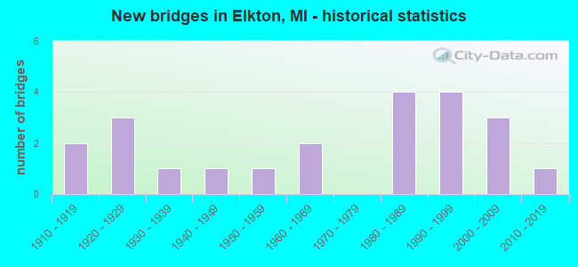
- New bridges - historical statistics
- 21910-1919
- 31920-1929
- 11930-1939
- 11940-1949
- 11950-1959
- 21960-1969
- 41980-1989
- 41990-1999
- 32000-2009
- 12010-2019

- Reconstructed bridges - Historical Statistics
- 11950-1959
- 11960-1969
- 21970-1979
- 01980-1989
- 21990-1999
- 12000-2009


- Bridge Condition - Deck
- 5.0%Very good
- 60.0%Good
- 10.0%Satisfactory
- 15.0%Fair
- 10.0%Poor

- Bridge Condition - Superstructure
- 5.0%Excellent
- 10.0%Very good
- 45.0%Good
- 10.0%Satisfactory
- 20.0%Fair
- 10.0%Poor

- Bridge Condition - Substructure
- 10.0%Very good
- 50.0%Good
- 15.0%Satisfactory
- 25.0%Fair

- Bridge Condition - Channel
- 14.3%Very good
- 33.3%Good
- 28.6%Satisfactory
- 14.3%Fair
- 4.8%Poor
- 4.8%Serious

- Bridge Condition - Culverts
- 50.0%Very good
- 50.0%Satisfactory
Find on map >> Show street view
Structure Number: 1362, Location: 7 MI N OF TEKONSHA (Lat: 42.188522, Lng: -85.006450), Route carried "on" structure: County highway , Year Built: 1918, Status: Posted for load, Structure Length: 0.73m (2.40ft), Average Daily Traffic: 61 (year 1994), Truck Traffic: 5%, Average Future Daily Traffic: 114 (year 2024), Design Load: H 10, Features Intersected: NOTTAWA CREEK, Facility Carried by Structure: H DRIVE SOUTH
Minimum Vertical Clearance: 30.48m (100.00ft), Kilometerpoint: 0.801, Lanes on structure: 2, Owner: County Highway Agency, Approaching Roadway Width: 5.5m (18.0ft), Material/Design: Steel, Design/Construction: Stringer/Multi-beam, Number Of Spans In Main Unit: 1, Length of Maximum Span: 7.3m (24.0ft), Curb-To-Curb Width: 4.9m (16.1ft), Out-to-Out Width: 5.3m (17.4ft)
Condition: Deck: Poor, Superstructure: Poor, Substructure: Fair, Channel: Satisfactory, Operating Rating: 27.9 metric tons, Method Used To Determine Operating Rating: Load Factor (LF) rating reported by rating factor (RF) method using MS18 loading, Inventory Rating: 16.8 metric tons, Method Used To Determine Inventory Rating: Load Factor (LF) rating reported by rating factor (RF) method using MS18 loading, Structural Evaluation: Meets minimum limits, Deck Geometry: High priority of corrective action, Waterway Adequacy: Equal to present desirable criteria, Approach Roadway Alignment: High priority of corrective action, Bridge Posting: Required (Relationship of Operating Rating to Maximum Legal Load: 30.0 - 39.9% below), Length Of Structure Improvement: 1.28m (4.20ft), Designated Inspection Frequency: Every 12 months, Inspection Date: September 2021, Bridge Improvement Cost: $117,000, Roadway Improvement Cost: $120,000, Total Project Cost: $237,000, Deck Structure Type: Concrete Cast-file-Place, Wearing Surface/Protective System: Wearing Surface: Monolithic Concrete
Find on map >> Show street view
Structure Number: 2529, Location: E OF MILLER RD & R06 (Lat: 42.964700, Lng: -83.795742), Route carried "on" structure: Interstate 69, Year Built: 1968, Year Reconstructed: 1998, Status: Open, Structure Length: 6.18m (20.28ft), Average Daily Traffic: 19,829 (year 2007), Truck Traffic: 14%, Average Future Daily Traffic: 24,684 (year 2018), Design Load: HS 20, Features Intersected: GTW RR
Minimum Vertical Clearance: 30.48m (100.00ft), Kilometerpoint: 10.892, Lanes on structure: 2, Base Highway Network: Yes (Inventory Route: 149, Subroute: 6), Owner: State Highway Agency, Approaching Roadway Width: 12.8m (42.0ft), Skew: 4 degrees, Material/Design: Steel, Design/Construction: Stringer/Multi-beam, Number Of Spans In Main Unit: 3, Length of Maximum Span: 21.6m (70.9ft), Curb-To-Curb Width: 11.7m (38.4ft), Out-to-Out Width: 12.9m (42.3ft)
Condition: Deck: Satisfactory, Superstructure: Fair, Substructure: Good, Operating Rating: 64.2 metric tons, Method Used To Determine Operating Rating: Load Factor (LF) rating reported by rating factor (RF) method using MS18 loading, Inventory Rating: 38.6 metric tons, Method Used To Determine Inventory Rating: Load Factor (LF) rating reported by rating factor (RF) method using MS18 loading, Structural Evaluation: Somewhat better than minimum adequacy, Deck Geometry: Equal to present minimum criteria, Approach Roadway Alignment: Equal to present desirable criteria, Designated Inspection Frequency: Every 24 months, Inspection Date: August 2020, Deck Structure Type: Concrete Cast-file-Place, Wearing Surface/Protective System: Wearing Surface: Epoxy Overlay, Deck Protection: Epoxy Coated Reinforcing
Find on map >> Show street view
Structure Number: 3455, Location: 0.5 MI E OF ELKTON (Lat: 43.818203, Lng: -83.168775), Route carried "on" structure: State highway 142, Year Built: 1946, Year Reconstructed: 2000, Status: Open, Structure Length: 1.32m (4.33ft), Average Daily Traffic: 5,274 (year 2007), Truck Traffic: 3%, Average Future Daily Traffic: 5,509 (year 2018), Design Load: HS 25 or greater, Features Intersected: PINNEBOG RIVER
Minimum Vertical Clearance: 30.48m (100.00ft), Kilometerpoint: 18.412, Lanes on structure: 2, Base Highway Network: Yes (Inventory Route: 103, Subroute: 8), Owner: State Highway Agency, Approaching Roadway Width: 6.7m (22.0ft), Skew: 1 degrees, Material/Design: Prestressed concrete, Design/Construction: Stringer/Multi-beam, Number Of Spans In Main Unit: 1, Length of Maximum Span: 12.6m (41.3ft), Curb-To-Curb Width: 13.1m (43.0ft), Out-to-Out Width: 14.2m (46.6ft)
Condition: Deck: Good, Superstructure: Very good, Substructure: Good, Channel: Fair, Operating Rating: 64.8 metric tons, Method Used To Determine Operating Rating: Load Factor (LF) rating reported by rating factor (RF) method using MS18 loading, Inventory Rating: 38.6 metric tons, Method Used To Determine Inventory Rating: Load Factor (LF) rating reported by rating factor (RF) method using MS18 loading, Structural Evaluation: Better than present minimum criteria, Deck Geometry: Somewhat better than minimum adequacy, Waterway Adequacy: Equal to present desirable criteria, Approach Roadway Alignment: Equal to present desirable criteria, Designated Inspection Frequency: Every 24 months, Inspection Date: September 2021, Deck Structure Type: Concrete Cast-file-Place, Wearing Surface/Protective System: Wearing Surface: Monolithic Concrete, Deck Protection: Epoxy Coated Reinforcing
Find on map >> Show street view
Structure Number: 3459, Location: 2.3 MI E OF ELKTON (Lat: 43.819675, Lng: -83.133689), Route carried "on" structure: State highway 142, Year Built: 2012, Status: Open, Structure Length: 1.44m (4.72ft), Average Daily Traffic: 5,200 (year 2012), Truck Traffic: 1%, Average Future Daily Traffic: 5,800 (year 2032), Design Load: Greater than HL93, Features Intersected: NETTLE RUN
Minimum Vertical Clearance: 30.48m (100.00ft), Kilometerpoint: 21.268, Lanes on structure: 2, Base Highway Network: Yes (Inventory Route: 103, Subroute: 8), Owner: State Highway Agency, Approaching Roadway Width: 13.4m (44.0ft), Skew: 2 degrees, Material/Design: Concrete, Design/Construction: Culvert, Number Of Spans In Main Unit: 1, Length of Maximum Span: 13.8m (45.3ft), Curb-To-Curb Width: 13.4m (44.0ft), Out-to-Out Width: 25.8m (84.6ft)
Condition: Channel: Good, Culverts: Very good, Operating Rating: 97.2 metric tons, Method Used To Determine Operating Rating: Load and Resistance Factor Rating (LRFR) rating reported by rating factor(RF) method using HL-93 loadings, Inventory Rating: 79.4 metric tons, Method Used To Determine Inventory Rating: Load and Resistance Factor Rating (LRFR) rating reported by rating factor(RF) method using HL-93 loadings, Structural Evaluation: Equal to present desirable criteria, Deck Geometry: Equal to present minimum criteria, Waterway Adequacy: Equal to present minimum criteria, Approach Roadway Alignment: Equal to present minimum criteria, Designated Inspection Frequency: Every 24 months, Inspection Date: July 2020, Deck Structure Type: Concrete Precast Panels, Wearing Surface/Protective System: Wearing Surface: Bituminous
Find on map >> Show street view
Structure Number: 3543, Location: SEC. 9-10 OLIVER TWP. (Lat: 43.826347, Lng: -83.181086), Route carried "on" structure: County highway 3235, Year Built: 1988, Status: Open, Structure Length: 1.70m (5.58ft), Average Daily Traffic: 1,860 (year 2009), Truck Traffic: 3%, Average Future Daily Traffic: 3,360 (year 2029), Design Load: HS 20, Features Intersected: ELKTON DRAIN, Facility Carried by Structure: ELKTON ROAD
Minimum Vertical Clearance: 30.48m (100.00ft), Kilometerpoint: 16.986, Lanes on structure: 2, Owner: County Highway Agency, Approaching Roadway Width: 9.8m (32.2ft), Material/Design: Prestressed concrete, Design/Construction: Tee Beam, Number Of Spans In Main Unit: 2, Length of Maximum Span: 8.2m (26.9ft), Curb-To-Curb Width: 8.9m (29.2ft), Out-to-Out Width: 9.8m (32.2ft)
Condition: Deck: Good, Superstructure: Fair, Substructure: Satisfactory, Channel: Good, Operating Rating: 81.7 metric tons, Method Used To Determine Operating Rating: Load Factor (LF), Inventory Rating: 48.9 metric tons, Method Used To Determine Inventory Rating: Load Factor (LF), Structural Evaluation: Somewhat better than minimum adequacy, Deck Geometry: Somewhat better than minimum adequacy, Waterway Adequacy: Equal to present desirable criteria, Approach Roadway Alignment: Equal to present minimum criteria, Designated Inspection Frequency: Every 24 months, Inspection Date: September 2021, Deck Structure Type: Concrete Precast Panels, Wearing Surface/Protective System: Wearing Surface: Bituminous
Find on map >> Show street view
Structure Number: 358, Location: SEC. 26-35 CHANDLER TWP. (Lat: 43.862461, Lng: -83.148722), Route carried "on" structure: ServiceCounty highway , Year Built: 1910, Year Reconstructed: 1963, Status: Posted for load, Structure Length: 1.37m (4.49ft), Average Daily Traffic: 65 (year 2009), Average Future Daily Traffic: 120 (year 2029), Design Load: H 15, Features Intersected: PINNEBOG RIVER, Facility Carried by Structure: CAMPBELL ROAD
Minimum Vertical Clearance: 30.48m (100.00ft), Kilometerpoint: 14.182, Lanes on structure: 2, Owner: County Highway Agency, Approaching Roadway Width: 7.3m (24.0ft), Material/Design: Steel, Design/Construction: Stringer/Multi-beam, Number Of Spans In Main Unit: 1, Length of Maximum Span: 13.4m (44.0ft), Curb-To-Curb Width: 6.2m (20.3ft), Out-to-Out Width: 6.6m (21.7ft)
Condition: Deck: Fair, Superstructure: Good, Substructure: Satisfactory, Channel: Satisfactory, Operating Rating: 33.0 metric tons, Method Used To Determine Operating Rating: Load Factor (LF) rating reported by rating factor (RF) method using MS18 loading, Inventory Rating: 19.8 metric tons, Method Used To Determine Inventory Rating: Load Factor (LF) rating reported by rating factor (RF) method using MS18 loading, Structural Evaluation: Somewhat better than minimum adequacy, Deck Geometry: Somewhat better than minimum adequacy, Waterway Adequacy: Equal to present desirable criteria, Approach Roadway Alignment: Equal to present minimum criteria, Bridge Posting: Required (Relationship of Operating Rating to Maximum Legal Load: > 39.9% below), Designated Inspection Frequency: Every 24 months, Inspection Date: September 2021, Deck Structure Type: Concrete Cast-file-Place, Wearing Surface/Protective System: Wearing Surface: Monolithic Concrete
Find on map >> Show street view
Structure Number: 3581, Location: SEC. 23-26 CHANDLER TWP. (Lat: 43.876717, Lng: -83.153253), Route carried "on" structure: ServiceCounty highway , Year Built: 1920, Year Reconstructed: 1969, Status: Open, Structure Length: 1.46m (4.79ft), Average Daily Traffic: 50 (year 2009), Truck Traffic: 3%, Average Future Daily Traffic: 90 (year 2029), Design Load: H 20, Features Intersected: PINNEBOG RIVER, Facility Carried by Structure: CROWN ROAD
Minimum Vertical Clearance: 30.48m (100.00ft), Kilometerpoint: 13.550, Lanes on structure: 2, Owner: County Highway Agency, Approaching Roadway Width: 10.4m (34.1ft), Material/Design: Steel, Design/Construction: Stringer/Multi-beam, Number Of Spans In Main Unit: 1, Length of Maximum Span: 14.0m (45.9ft), Curb-To-Curb Width: 7.3m (24.0ft), Out-to-Out Width: 7.3m (24.0ft)
Condition: Deck: Good, Superstructure: Good, Substructure: Fair, Channel: Good, Inventory Rating: 61.5 metric tons, Method Used To Determine Inventory Rating: Load Factor (LF), Structural Evaluation: Somewhat better than minimum adequacy, Deck Geometry: Equal to present minimum criteria, Waterway Adequacy: Equal to present desirable criteria, Approach Roadway Alignment: Equal to present minimum criteria, Designated Inspection Frequency: Every 24 months, Inspection Date: September 2021, Deck Structure Type: Concrete Cast-file-Place, Wearing Surface/Protective System: Wearing Surface: Monolithic Concrete
Find on map >> Show street view
Structure Number: 3585, Location: SEC. 30 COLFAX TWP. (Lat: 43.784306, Lng: -83.116714), Route carried "on" structure: ServiceCounty highway , Year Built: 2001, Status: Open, Structure Length: 2.17m (7.12ft), Average Daily Traffic: 100 (year 2009), Truck Traffic: 1%, Average Future Daily Traffic: 180 (year 2029), Design Load: HS 20, Features Intersected: PINNEBOG RIVER, Facility Carried by Structure: GLASSBURNER ROAD
Minimum Vertical Clearance: 30.48m (100.00ft), Kilometerpoint: 0.309, Lanes on structure: 2, Owner: County Highway Agency, Approaching Roadway Width: 9.1m (29.9ft), Material/Design: Prestressed concrete, Design/Construction: Box Beam or Girders - Multiple, Number Of Spans In Main Unit: 1, Length of Maximum Span: 21.7m (71.2ft), Curb-To-Curb Width: 9.0m (29.5ft), Out-to-Out Width: 9.5m (31.2ft)
Condition: Deck: Satisfactory, Superstructure: Satisfactory, Substructure: Good, Channel: Fair, Operating Rating: 43.7 metric tons, Method Used To Determine Operating Rating: Load and Resistance Factor Rating (LRFR) rating reported by rating factor(RF) method using HL-93 loadings, Inventory Rating: 22.0 metric tons, Method Used To Determine Inventory Rating: Load and Resistance Factor Rating (LRFR) rating reported by rating factor(RF) method using HL-93 loadings, Structural Evaluation: Equal to present minimum criteria, Waterway Adequacy: Superior to present desirable criteria, Approach Roadway Alignment: Equal to present minimum criteria, Designated Inspection Frequency: Every 24 months, Inspection Date: September 2021, Wearing Surface/Protective System: Wearing Surface: Bituminous, Membrane: Built-up
Find on map >> Show street view
Structure Number: 3586, Location: SEC. 30 COLFAX TWP (Lat: 43.786119, Lng: -83.120544), Route carried "on" structure: ServiceCounty highway , Year Built: 1929, Status: Posted for load, Structure Length: 1.28m (4.20ft), Average Daily Traffic: 150 (year 2009), Truck Traffic: 2%, Average Future Daily Traffic: 270 (year 2029), Design Load: H 15, Features Intersected: PINNEBOG RIVER, Facility Carried by Structure: GRASSMERE ROAD
Minimum Vertical Clearance: 30.48m (100.00ft), Kilometerpoint: 12.293, Lanes on structure: 2, Owner: County Highway Agency, Approaching Roadway Width: 11.0m (36.1ft), Skew: 3 degrees, Material/Design: Steel, Design/Construction: Stringer/Multi-beam, Number Of Spans In Main Unit: 1, Length of Maximum Span: 11.5m (37.7ft), Curb-To-Curb Width: 9.2m (30.2ft), Out-to-Out Width: 11.1m (36.4ft)
Condition: Deck: Fair, Superstructure: Fair, Substructure: Fair, Channel: Good, Operating Rating: 39.5 metric tons, Method Used To Determine Operating Rating: Load Factor (LF) rating reported by rating factor (RF) method using MS18 loading, Inventory Rating: 23.7 metric tons, Method Used To Determine Inventory Rating: Load Factor (LF) rating reported by rating factor (RF) method using MS18 loading, Structural Evaluation: Somewhat better than minimum adequacy, Deck Geometry: Equal to present minimum criteria, Waterway Adequacy: Equal to present desirable criteria, Approach Roadway Alignment: Better than present minimum criteria, Bridge Posting: Required (Relationship of Operating Rating to Maximum Legal Load: 20.0 - 29.9% below), Length Of Structure Improvement: 1.95m (6.40ft), Designated Inspection Frequency: Every 24 months, Inspection Date: September 2021, Bridge Improvement Cost: $225,000, Roadway Improvement Cost: $80,000, Total Project Cost: $335,000, Deck Structure Type: Concrete Cast-file-Place, Wearing Surface/Protective System: Wearing Surface: Monolithic Concrete
Find on map >> Show street view
Structure Number: 3631, Location: SEC. 14-23 OLIVER TWP. (Lat: 43.804236, Lng: -83.160833), Route carried "on" structure: ServiceCounty highway , Year Built: 1925, Year Reconstructed: 1979, Status: Open, Structure Length: 1.40m (4.59ft), Average Daily Traffic: 100 (year 2009), Truck Traffic: 1%, Average Future Daily Traffic: 180 (year 2029), Design Load: HS 20, Features Intersected: PINNEBOG RIVER, Facility Carried by Structure: GEIGER ROAD
Minimum Vertical Clearance: 30.48m (100.00ft), Kilometerpoint: 21.551, Lanes on structure: 2, Owner: County Highway Agency, Approaching Roadway Width: 9.1m (29.9ft), Material/Design: Prestressed concrete, Design/Construction: Tee Beam, Number Of Spans In Main Unit: 1, Length of Maximum Span: 8.8m (28.9ft), Curb-To-Curb Width: 8.5m (27.9ft), Out-to-Out Width: 9.1m (29.9ft)
Condition: Deck: Fair, Superstructure: Satisfactory, Substructure: Fair, Channel: Serious, Operating Rating: 96.2 metric tons, Method Used To Determine Operating Rating: Load Factor (LF), Inventory Rating: 57.7 metric tons, Method Used To Determine Inventory Rating: Load Factor (LF), Structural Evaluation: Somewhat better than minimum adequacy, Deck Geometry: Better than present minimum criteria, Waterway Adequacy: Equal to present desirable criteria, Approach Roadway Alignment: Equal to present minimum criteria, Designated Inspection Frequency: Every 24 months, Inspection Date: September 2021, Deck Structure Type: Concrete Precast Panels, Wearing Surface/Protective System: Wearing Surface: Bituminous
Find on map >> Show street view
Structure Number: 3632, Location: SEC. 15 OLIVER TWP. (Lat: 43.811392, Lng: -83.165350), Route carried "on" structure: ServiceCounty highway , Year Built: 1958, Year Reconstructed: 1978, Status: Posted for load, Structure Length: 1.30m (4.27ft), Average Daily Traffic: 50 (year 2007), Average Future Daily Traffic: 90 (year 2027), Design Load: H 20, Features Intersected: PINNEBOG RIVER, Facility Carried by Structure: EBY ROAD
Minimum Vertical Clearance: 30.48m (100.00ft), Kilometerpoint: 1.242, Lanes on structure: 2, Owner: County Highway Agency, Approaching Roadway Width: 9.8m (32.2ft), Material/Design: Steel, Design/Construction: Stringer/Multi-beam, Number Of Spans In Main Unit: 1, Length of Maximum Span: 13.0m (42.7ft), Curb-To-Curb Width: 8.5m (27.9ft), Out-to-Out Width: 8.5m (27.9ft)
Condition: Deck: Good, Superstructure: Good, Substructure: Good, Channel: Good, Operating Rating: 38.2 metric tons, Method Used To Determine Operating Rating: Load Factor (LF) rating reported by rating factor (RF) method using MS18 loading, Inventory Rating: 23.0 metric tons, Method Used To Determine Inventory Rating: Load Factor (LF) rating reported by rating factor (RF) method using MS18 loading, Structural Evaluation: Equal to present minimum criteria, Deck Geometry: Better than present minimum criteria, Waterway Adequacy: Better than present minimum criteria, Approach Roadway Alignment: Better than present minimum criteria, Bridge Posting: Required (Relationship of Operating Rating to Maximum Legal Load: 10.0 - 19.9% below), Designated Inspection Frequency: Every 24 months, Inspection Date: September 2021, Deck Structure Type: Concrete Cast-file-Place, Wearing Surface/Protective System: Wearing Surface: Monolithic Concrete
Find on map >> Show street view
Structure Number: 3633, Location: SEC. 3-10 OLIVER TWP. (Lat: 43.832925, Lng: -83.173828), Route carried "on" structure: ServiceCounty highway , Year Built: 1988, Status: Open, Structure Length: 1.67m (5.48ft), Average Daily Traffic: 435 (year 2009), Truck Traffic: 1%, Average Future Daily Traffic: 785 (year 2029), Design Load: HS 20, Features Intersected: PINNEBOG RIVER, Facility Carried by Structure: RICHARDSON ROAD
Minimum Vertical Clearance: 30.48m (100.00ft), Kilometerpoint: 16.458, Lanes on structure: 2, Owner: County Highway Agency, Approaching Roadway Width: 9.1m (29.9ft), Skew: 1 degrees, Material/Design: Prestressed concrete, Design/Construction: Tee Beam, Number Of Spans In Main Unit: 2, Length of Maximum Span: 8.0m (26.2ft), Curb-To-Curb Width: 8.9m (29.2ft), Out-to-Out Width: 9.8m (32.2ft)
Condition: Deck: Good, Superstructure: Good, Substructure: Good, Channel: Poor, Operating Rating: 44.7 metric tons, Method Used To Determine Operating Rating: Load and Resistance Factor Rating (LRFR) rating reported by rating factor(RF) method using HL-93 loadings, Inventory Rating: 34.3 metric tons, Method Used To Determine Inventory Rating: Load and Resistance Factor Rating (LRFR) rating reported by rating factor(RF) method using HL-93 loadings, Structural Evaluation: Better than present minimum criteria, Deck Geometry: Somewhat better than minimum adequacy, Waterway Adequacy: Equal to present desirable criteria, Approach Roadway Alignment: Equal to present desirable criteria, Designated Inspection Frequency: Every 24 months, Inspection Date: September 2021, Deck Structure Type: Concrete Precast Panels, Wearing Surface/Protective System: Wearing Surface: Bituminous
Find on map >> Show street view
Structure Number: 3634, Location: SEC. 10 OLIVER TWP. (Lat: 43.822764, Lng: -83.171042), Route carried "on" structure: ServiceCounty highway , Year Built: 1992, Status: Open, Structure Length: 2.01m (6.59ft), Average Daily Traffic: 100 (year 2009), Truck Traffic: 1%, Average Future Daily Traffic: 180 (year 2029), Design Load: HS 20, Features Intersected: PINNEBOG RIVER, Facility Carried by Structure: EWALD ROAD
Minimum Vertical Clearance: 30.48m (100.00ft), Kilometerpoint: 0.483, Lanes on structure: 2, Owner: County Highway Agency, Approaching Roadway Width: 9.1m (29.9ft), Skew: 1 degrees, Material/Design: Prestressed concrete, Design/Construction: Box Beam or Girders - Multiple, Number Of Spans In Main Unit: 2, Length of Maximum Span: 9.6m (31.5ft), Curb-To-Curb Width: 9.6m (31.5ft), Out-to-Out Width: 10.5m (34.4ft)
Condition: Deck: Good, Superstructure: Fair, Substructure: Good, Channel: Satisfactory, Operating Rating: 38.6 metric tons, Method Used To Determine Operating Rating: Load and Resistance Factor Rating (LRFR) rating reported by rating factor(RF) method using HL-93 loadings, Inventory Rating: 29.8 metric tons, Method Used To Determine Inventory Rating: Load and Resistance Factor Rating (LRFR) rating reported by rating factor(RF) method using HL-93 loadings, Structural Evaluation: Somewhat better than minimum adequacy, Deck Geometry: Better than present minimum criteria, Waterway Adequacy: Better than present minimum criteria, Approach Roadway Alignment: Equal to present minimum criteria, Designated Inspection Frequency: Every 24 months, Inspection Date: September 2021, Deck Structure Type: Concrete Precast Panels, Wearing Surface/Protective System: Wearing Surface: Bituminous, Membrane: Preformed Fabric
Find on map >> Show street view
Structure Number: 3635, Location: SEC. 23-24 OLIVER TWP. (Lat: 43.792603, Lng: -83.140775), Route carried "on" structure: ServiceCounty highway , Year Built: 1985, Status: Open, Structure Length: 0.97m (3.18ft), Average Daily Traffic: 75 (year 2009), Truck Traffic: 1%, Average Future Daily Traffic: 135 (year 2029), Design Load: HS 20, Features Intersected: PINNEBOG RIVER, Facility Carried by Structure: MOORE ROAD
Minimum Vertical Clearance: 30.48m (100.00ft), Kilometerpoint: 13.096, Lanes on structure: 2, Owner: County Highway Agency, Approaching Roadway Width: 8.5m (27.9ft), Material/Design: Prestressed concrete, Design/Construction: Tee Beam, Number Of Spans In Main Unit: 1, Length of Maximum Span: 8.8m (28.9ft), Curb-To-Curb Width: 9.0m (29.5ft), Out-to-Out Width: 9.9m (32.5ft)
Condition: Deck: Good, Superstructure: Good, Substructure: Good, Channel: Fair, Operating Rating: 75.6 metric tons, Method Used To Determine Operating Rating: Load Factor (LF), Inventory Rating: 45.3 metric tons, Method Used To Determine Inventory Rating: Load Factor (LF), Structural Evaluation: Better than present minimum criteria, Deck Geometry: Better than present minimum criteria, Waterway Adequacy: Equal to present desirable criteria, Approach Roadway Alignment: Better than present minimum criteria, Designated Inspection Frequency: Every 24 months, Inspection Date: September 2021, Deck Structure Type: Concrete Precast Panels, Wearing Surface/Protective System: Wearing Surface: Bituminous, Membrane: Preformed Fabric, Deck Protection: Epoxy Coated Reinforcing
Find on map >> Show street view
Structure Number: 4503, Location: 1 M S 3.7 M W OF WATERLOO (Lat: 42.336922, Lng: -84.209767), Route carried "on" structure: County highway , Year Built: 1986, Status: Open, Structure Length: 1.03m (3.38ft), Average Daily Traffic: 850 (year 2000), Average Future Daily Traffic: 1,000 (year 2020), Design Load: HS 20, Features Intersected: PORTAGE RIVER S BRANCH, Facility Carried by Structure: MT. HOPE ROAD
Minimum Vertical Clearance: 30.48m (100.00ft), Kilometerpoint: 16.137, Lanes on structure: 2, Owner: County Highway Agency, Approaching Roadway Width: 7.9m (25.9ft), Material/Design: Prestressed concrete, Design/Construction: Box Beam or Girders - Multiple, Number Of Spans In Main Unit: 1, Length of Maximum Span: 10.3m (33.8ft), Curb-To-Curb Width: 10.4m (34.1ft), Out-to-Out Width: 11.4m (37.4ft)
Condition: Deck: Good, Superstructure: Good, Substructure: Good, Channel: Satisfactory, Operating Rating: 55.4 metric tons, Method Used To Determine Operating Rating: Load Factor (LF) rating reported by rating factor (RF) method using MS18 loading, Inventory Rating: 33.4 metric tons, Method Used To Determine Inventory Rating: Load Factor (LF) rating reported by rating factor (RF) method using MS18 loading, Structural Evaluation: Better than present minimum criteria, Deck Geometry: Equal to present minimum criteria, Waterway Adequacy: Equal to present desirable criteria, Approach Roadway Alignment: Equal to present desirable criteria, Designated Inspection Frequency: Every 24 months, Inspection Date: October 2020, Deck Structure Type: Concrete Cast-file-Place, Wearing Surface/Protective System: Wearing Surface: Bituminous, Membrane: Preformed Fabric, Deck Protection: Epoxy Coated Reinforcing
Find on map >> Show street view
Structure Number: 4504, Location: 3.5 MI W .8 MI N WATERLOO (Lat: 42.365706, Lng: -84.210064), Route carried "on" structure: County highway , Year Built: 2007, Status: Open, Structure Length: 1.52m (4.99ft), Average Daily Traffic: 900 (year 2006), Truck Traffic: 3%, Average Future Daily Traffic: 1,100 (year 2026), Design Load: HS 20, Features Intersected: PORTAGE RIVER N BRANCH, Facility Carried by Structure: MT HOPE ROAD
Minimum Vertical Clearance: 30.48m (100.00ft), Kilometerpoint: 19.334, Lanes on structure: 2, Owner: County Highway Agency, Approaching Roadway Width: 8.5m (27.9ft), Skew: 3 degrees, Material/Design: Prestressed concrete, Design/Construction: Box Beam or Girders - Multiple, Number Of Spans In Main Unit: 1, Length of Maximum Span: 14.8m (48.6ft), Curb-To-Curb Width: 8.8m (28.9ft), Out-to-Out Width: 9.5m (31.2ft)
Condition: Deck: Good, Superstructure: Good, Substructure: Good, Channel: Satisfactory, Operating Rating: 84.0 metric tons, Method Used To Determine Operating Rating: Load Factor (LF), Inventory Rating: 50.3 metric tons, Method Used To Determine Inventory Rating: Load Factor (LF), Structural Evaluation: Better than present minimum criteria, Deck Geometry: Somewhat better than minimum adequacy, Waterway Adequacy: Superior to present desirable criteria, Approach Roadway Alignment: Equal to present desirable criteria, Designated Inspection Frequency: Every 24 months, Inspection Date: October 2020, Deck Structure Type: Concrete Cast-file-Place, Wearing Surface/Protective System: Wearing Surface: Integral Concrete, Deck Protection: Epoxy Coated Reinforcing
Find on map >> Show street view
Structure Number: 5376, Location: SEC. 25-36 MARATHON TWP. (Lat: 43.159783, Lng: -83.350925), Route carried "on" structure: County highway 4464, Year Built: 1996, Status: Open, Structure Length: 4.11m (13.48ft), Average Daily Traffic: 1,870 (year 2008), Average Future Daily Traffic: 2,282 (year 2028), Design Load: HS 20, Features Intersected: SOUTH BR. FLINT RIVER, Facility Carried by Structure: COLUMBIAVILLE ROAD
Minimum Vertical Clearance: 30.48m (100.00ft), Kilometerpoint: 4.482, Lanes on structure: 2, Owner: County Highway Agency, Approaching Roadway Width: 9.1m (29.9ft), Skew: 3 degrees, Material/Design: Prestressed concrete, Design/Construction: Tee Beam, Number Of Spans In Main Unit: 3, Length of Maximum Span: 13.7m (44.9ft), Curb-To-Curb Width: 12.2m (40.0ft), Out-to-Out Width: 13.2m (43.3ft)
Condition: Deck: Good, Superstructure: Good, Substructure: Good, Channel: Good, Operating Rating: 54.8 metric tons, Method Used To Determine Operating Rating: Load Factor (LF) rating reported by rating factor (RF) method using MS18 loading, Inventory Rating: 32.7 metric tons, Method Used To Determine Inventory Rating: Load Factor (LF) rating reported by rating factor (RF) method using MS18 loading, Structural Evaluation: Better than present minimum criteria, Deck Geometry: Better than present minimum criteria, Waterway Adequacy: Equal to present desirable criteria, Approach Roadway Alignment: Equal to present desirable criteria, Designated Inspection Frequency: Every 24 months, Inspection Date: July 2021, Deck Structure Type: Concrete Cast-file-Place, Wearing Surface/Protective System: Wearing Surface: Bituminous, Membrane: Preformed Fabric, Deck Protection: Epoxy Coated Reinforcing
Find on map >> Show street view
Structure Number: 5609, Location: 0.1 MI W OF CARSON HWY (Lat: 41.941500, Lng: -84.025131), Route carried "on" structure: County highway , Year Built: 1994, Status: Open, Structure Length: 1.05m (3.44ft), Average Daily Traffic: 675 (year 2013), Truck Traffic: 2%, Average Future Daily Traffic: 800 (year 2031), Design Load: HS 20, Features Intersected: BEAVER CREEK, Facility Carried by Structure: MOORE RD
Minimum Vertical Clearance: 30.48m (100.00ft), Kilometerpoint: 4.944, Lanes on structure: 2, Owner: County Highway Agency, Approaching Roadway Width: 9.1m (29.9ft), Material/Design: Concrete, Design/Construction: Arch - Deck, Number Of Spans In Main Unit: 1, Length of Maximum Span: 9.8m (32.2ft), Curb-To-Curb Width: 9.1m (29.9ft), Out-to-Out Width: 9.7m (31.8ft)
Condition: Deck: Good, Superstructure: Very good, Substructure: Very good, Channel: Good, Operating Rating: 54.5 metric tons, Method Used To Determine Operating Rating: Field evaluation and documented engineering judgment, Inventory Rating: 32.7 metric tons, Method Used To Determine Inventory Rating: Field evaluation and documented engineering judgment, Structural Evaluation: Equal to present desirable criteria, Deck Geometry: Equal to present minimum criteria, Waterway Adequacy: Superior to present desirable criteria, Approach Roadway Alignment: Equal to present desirable criteria, Designated Inspection Frequency: Every 24 months, Inspection Date: June 2021, Wearing Surface/Protective System: Wearing Surface: Monolithic Concrete, Deck Protection: Epoxy Coated Reinforcing
Find on map >> Show street view
Structure Number: 5696, Location: 0.1 MI S OF SUTTON RD (Lat: 41.950578, Lng: -83.780522), Route carried "on" structure: County highway , Year Built: 2003, Status: Open, Structure Length: 1.57m (5.15ft), Average Daily Traffic: 49 (year 2011), Truck Traffic: 1%, Average Future Daily Traffic: 150 (year 2031), Design Load: HS 25 or greater, Features Intersected: SCHENK BEN KELLY DRAIN, Facility Carried by Structure: BUCHOLTZ HWY
Minimum Vertical Clearance: 30.48m (100.00ft), Kilometerpoint: 6.856, Lanes on structure: 2, Owner: County Highway Agency, Approaching Roadway Width: 10.4m (34.1ft), Material/Design: Prestressed concrete, Design/Construction: Box Beam or Girders - Multiple, Number Of Spans In Main Unit: 1, Length of Maximum Span: 13.5m (44.3ft), Curb-To-Curb Width: 8.8m (28.9ft), Out-to-Out Width: 9.5m (31.2ft)
Condition: Deck: Very good, Superstructure: Excellent, Substructure: Very good, Channel: Very good, Operating Rating: 70.1 metric tons, Method Used To Determine Operating Rating: Load Factor (LF), Inventory Rating: 42.0 metric tons, Method Used To Determine Inventory Rating: Load Factor (LF), Structural Evaluation: Equal to present desirable criteria, Waterway Adequacy: Superior to present desirable criteria, Approach Roadway Alignment: Superior to present desirable criteria, Designated Inspection Frequency: Every 24 months, Inspection Date: Febuary 2021, Deck Structure Type: Concrete Cast-file-Place, Wearing Surface/Protective System: Wearing Surface: Monolithic Concrete
Find on map >> Show street view
Structure Number: 5823, Location: SEC 30 TYRONE TWP (Lat: 42.707625, Lng: -83.784022), Route carried "on" structure: County highway , Year Built: 1939, Status: Posted for load, Structure Length: 1.22m (4.00ft), Average Daily Traffic: 8,772 (year 2010), Truck Traffic: 2%, Average Future Daily Traffic: 8,900 (year 2022), Design Load: HS 20+Mod, Features Intersected: ORE CREEK, Facility Carried by Structure: FAUSSETT ROAD
Minimum Vertical Clearance: 30.48m (100.00ft), Kilometerpoint: 12.975, Lanes on structure: 2, Owner: County Highway Agency, Approaching Roadway Width: 9.1m (29.9ft), Material/Design: Steel, Design/Construction: Stringer/Multi-beam, Number Of Spans In Main Unit: 1, Length of Maximum Span: 11.8m (38.7ft), Curb-To-Curb Width: 8.8m (28.9ft), Out-to-Out Width: 10.4m (34.1ft)
Condition: Deck: Poor, Superstructure: Poor, Substructure: Satisfactory, Channel: Very good, Operating Rating: 32.7 metric tons, Method Used To Determine Operating Rating: Load Factor (LF) rating reported by rating factor (RF) method using MS18 loading, Inventory Rating: 19.4 metric tons, Method Used To Determine Inventory Rating: Load Factor (LF) rating reported by rating factor (RF) method using MS18 loading, Structural Evaluation: Meets minimum limits, Deck Geometry: High priority of replacement, Waterway Adequacy: Equal to present desirable criteria, Approach Roadway Alignment: Equal to present desirable criteria, Bridge Posting: Required (Relationship of Operating Rating to Maximum Legal Load: 30.0 - 39.9% below), Length Of Structure Improvement: 1.22m (4.00ft), Designated Inspection Frequency: Every 24 months, Inspection Date: November 2020, Bridge Improvement Cost: $386,000, Roadway Improvement Cost: $213,000, Total Project Cost: $599,000, Deck Structure Type: Concrete Cast-file-Place, Wearing Surface/Protective System: Wearing Surface: Monolithic Concrete
Find on map >> Show street view
Structure Number: 6141, Location: 0.2 MI E OF MT CLEMENS (Lat: 42.590761, Lng: -82.857475), Route carried "on" structure: Interstate 94, Year Built: 1963, Year Reconstructed: 1998, Status: Open, Structure Length: 10.91m (35.79ft), Average Daily Traffic: 49,601 (year 2007), Truck Traffic: 6%, Average Future Daily Traffic: 48,486 (year 2018), Design Load: HS 20+Mod, Features Intersected: CLINTON RIVER, N&S RDS
Minimum Vertical Clearance: 30.48m (100.00ft), Kilometerpoint: 18.687, Lanes on structure: 4, Lanes under structure: 4, Base Highway Network: Yes (Inventory Route: 79, Subroute: 2), Owner: State Highway Agency, Approaching Roadway Width: 18.2m (59.7ft), Navigation Control: Yes ( Vertical Clearance: 0.3m (1.0ft), Horizontal Clearance: 17.0m (55.8ft)), Material/Design: Steel, Design/Construction: Stringer/Multi-beam, Number Of Spans In Main Unit: 6, Length of Maximum Span: 18.4m (60.4ft), Curb-To-Curb Width: 17.3m (56.8ft), Out-to-Out Width: 18.3m (60.0ft)
Condition: Deck: Good, Superstructure: Good, Substructure: Fair, Channel: Very good, Operating Rating: 68.4 metric tons, Method Used To Determine Operating Rating: Load Factor (LF) rating reported by rating factor (RF) method using MS18 loading, Inventory Rating: 40.8 metric tons, Method Used To Determine Inventory Rating: Load Factor (LF) rating reported by rating factor (RF) method using MS18 loading, Structural Evaluation: Somewhat better than minimum adequacy, Deck Geometry: Meets minimum limits, Underclear: Meets minimum limits, Waterway Adequacy: Better than present minimum criteria, Approach Roadway Alignment: Better than present minimum criteria, Designated Inspection Frequency: Every 24 months, Underwater Inspection Frequency: Every 60 months, Inspection Date: June 2021, Underwater Inspection Date: April 2020, Deck Structure Type: Concrete Cast-file-Place, Wearing Surface/Protective System: Wearing Surface: Latex Concrete
Find on map >> Show street view
Structure Number: 939, Location: 0.2 MI N OF LUNNEY (Lat: 43.445044, Lng: -84.249753), Route carried "on" structure: ServiceCounty highway , Year Built: 1992, Status: Open, Structure Length: 1.03m (3.38ft), Average Daily Traffic: 172 (year 2008), Truck Traffic: 5%, Average Future Daily Traffic: 181 (year 2018), Features Intersected: WHITMORE DRAIN, Facility Carried by Structure: BRENNAN ROAD
Minimum Vertical Clearance: 30.48m (100.00ft), Kilometerpoint: 5.887, Lanes on structure: 2, Owner: County Highway Agency, Approaching Roadway Width: 6.7m (22.0ft), Skew: 4 degrees, Material/Design: Concrete, Design/Construction: Culvert, Number Of Spans In Main Unit: 1, Length of Maximum Span: 6.7m (22.0ft), Curb-To-Curb Width: 9.1m (29.9ft), Out-to-Out Width: 10.0m (32.8ft)
Condition: Channel: Satisfactory, Culverts: Satisfactory, Operating Rating: 77.4 metric tons, Method Used To Determine Operating Rating: Load Factor (LF) rating reported by rating factor (RF) method using MS18 loading, Inventory Rating: 46.3 metric tons, Method Used To Determine Inventory Rating: Load Factor (LF) rating reported by rating factor (RF) method using MS18 loading, Structural Evaluation: Equal to present minimum criteria, Waterway Adequacy: Better than present minimum criteria, Approach Roadway Alignment: Equal to present desirable criteria, Designated Inspection Frequency: Every 24 months, Inspection Date: September 2020, Deck Structure Type: Concrete Precast Panels, Wearing Surface/Protective System: Wearing Surface: Gravel, Membrane: Built-up, Deck Protection: Epoxy Coated Reinforcing