Bridge Statistics for Elko, Nevada (NV)
Condition, Traffic, Stress, Structural Evaluation, Project Costs
- National Bridge Inventory (NBI) Statistics
- 44Number of bridges
- 466ft / 142mTotal length
- $8,977,000Total costs
- 278,429Total average daily traffic
- 46,883Total average daily truck traffic
- National Bridge Inventory (NBI) Registered Bridges for Elko
- No street view available for this location
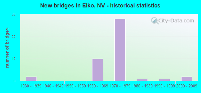
- New bridges - historical statistics
- 21930-1939
- 101960-1969
- 281970-1979
- 11980-1989
- 11990-1999
- 22000-2009
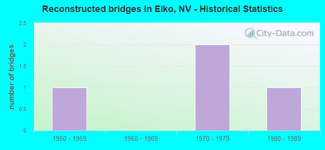
- Reconstructed bridges - Historical Statistics
- 11950-1959
- 01960-1969
- 21970-1979
- 11980-1989
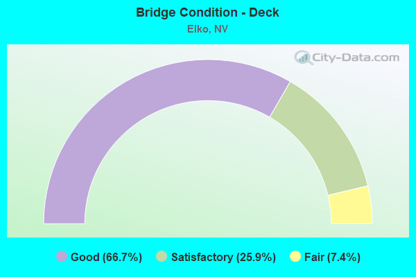
- Bridge Condition - Deck
- 66.7%Good
- 25.9%Satisfactory
- 7.4%Fair
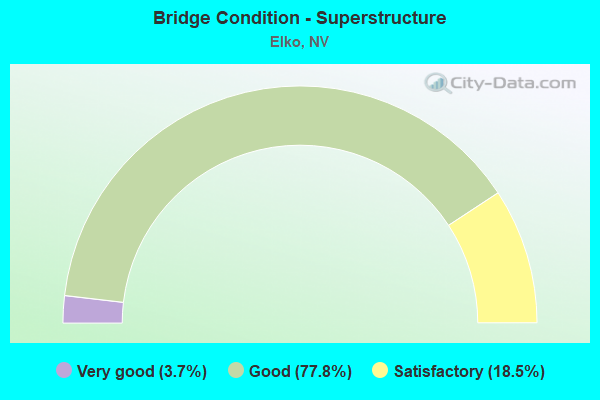
- Bridge Condition - Superstructure
- 3.7%Very good
- 77.8%Good
- 18.5%Satisfactory
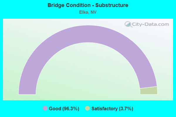
- Bridge Condition - Substructure
- 96.3%Good
- 3.7%Satisfactory
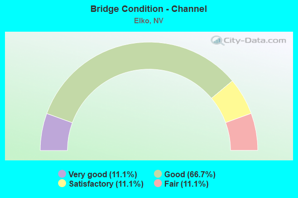
- Bridge Condition - Channel
- 11.1%Very good
- 66.7%Good
- 11.1%Satisfactory
- 11.1%Fair
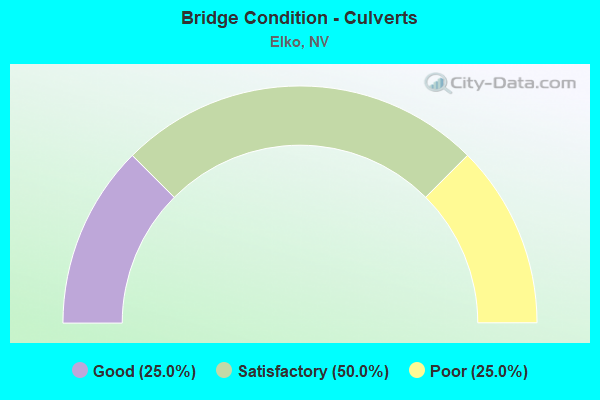
- Bridge Condition - Culverts
- 25.0%Good
- 50.0%Satisfactory
- 25.0%Poor
Find on map >> Show street view
Structure Number: B 48E, Location: EAST OF ELKO (Lat: 40.949514, Lng: -115.603125), Route carried "on" structure: Interstate 80, Year Built: 1930, Year Reconstructed: 1962, Status: Open, Structure Length: 1.03m (3.38ft), Average Daily Traffic: 9,300 (year 2017), Truck Traffic: 20%, Average Future Daily Traffic: 10,276 (year 2040), Design Load: HS 20, Features Intersected: CREEK
Minimum Vertical Clearance: 30+ m (98+ ft), Kilometerpoint: 506.287, Lanes on structure: 2, Base Highway Network: Yes, Owner: State Highway Agency, Approaching Roadway Width: 11.6m (38.1ft), Material/Design: Concrete, Design/Construction: Culvert, Number Of Spans In Main Unit: 3, Length of Maximum Span: 3.0m (9.8ft)
Condition: Channel: Fair, Culverts: Satisfactory, Operating Rating: 49.9 metric tons, Method Used To Determine Operating Rating: Load Factor (LF), Inventory Rating: 30.0 metric tons, Method Used To Determine Inventory Rating: Load Factor (LF), Structural Evaluation: Equal to present minimum criteria, Waterway Adequacy: Better than present minimum criteria, Approach Roadway Alignment: Equal to present desirable criteria, Designated Inspection Frequency: Every 24 months, Inspection Date: August 2020
Find on map >> Show street view
Structure Number: B 356, Location: SOUTH OF ELKO (Lat: 40.622742, Lng: -115.726975), Route carried "on" structure: County highway , Year Built: 2002, Status: Open, Structure Length: 3.04m (9.97ft), Average Daily Traffic: 125 (year 2017), Truck Traffic: 3%, Average Future Daily Traffic: 138 (year 2040), Design Load: HS 20+Mod, Features Intersected: S FORK HUMBOLDT RVR, Facility Carried by Structure: LWR S FORK RD
Minimum Vertical Clearance: 30+ m (98+ ft), Kilometerpoint: 0.000, Lanes on structure: 2, Owner: County Highway Agency, Approaching Roadway Width: 6.8m (22.3ft), Skew: 3 degrees, Material/Design: Steel, Design/Construction: Stringer/Multi-beam, Number Of Spans In Main Unit: 1, Length of Maximum Span: 30.0m (98.4ft), Curb-To-Curb Width: 6.7m (22.0ft), Out-to-Out Width: 7.6m (24.9ft)
Condition: Deck: Good, Superstructure: Very good, Substructure: Good, Channel: Good, Operating Rating: 81.3 metric tons, Method Used To Determine Operating Rating: Load Factor (LF), Inventory Rating: 48.6 metric tons, Method Used To Determine Inventory Rating: Load Factor (LF), Structural Evaluation: Better than present minimum criteria, Deck Geometry: Meets minimum limits, Waterway Adequacy: Equal to present desirable criteria, Approach Roadway Alignment: Equal to present desirable criteria, Length Of Structure Improvement: 4.00m (13.12ft), Designated Inspection Frequency: Every 24 months, Inspection Date: July 2020, Bridge Improvement Cost: $321,000, Roadway Improvement Cost: $32,000, Total Project Cost: $482,000, Deck Structure Type: Concrete Cast-file-Place, Wearing Surface/Protective System: Wearing Surface: Monolithic Concrete
Find on map >> Show street view
Structure Number: B 39, Location: NORTH OF ELKO (Lat: 41.479706, Lng: -115.814194), Route carried "on" structure: State highway 225, Year Built: 1939, Status: Open, Structure Length: 0.67m (2.20ft), Average Daily Traffic: 750 (year 2017), Truck Traffic: 16%, Average Future Daily Traffic: 1,000 (year 2040), Design Load: HS 20, Features Intersected: HUMBOLDT RVR
Minimum Vertical Clearance: 30+ m (98+ ft), Kilometerpoint: 81.101, Lanes on structure: 2, Base Highway Network: Yes, Owner: State Highway Agency, Approaching Roadway Width: 8.5m (27.9ft), Material/Design: Concrete, Design/Construction: Culvert, Number Of Spans In Main Unit: 2, Length of Maximum Span: 3.0m (9.8ft)
Condition: Channel: Good, Culverts: Good, Operating Rating: 49.9 metric tons, Method Used To Determine Operating Rating: Load Factor (LF), Inventory Rating: 30.0 metric tons, Method Used To Determine Inventory Rating: Load Factor (LF), Structural Evaluation: Better than present minimum criteria, Waterway Adequacy: Equal to present minimum criteria, Approach Roadway Alignment: Better than present minimum criteria, Designated Inspection Frequency: Every 24 months, Inspection Date: August 2020
Find on map >> Show street view
Structure Number: B 792, Location: NEAR ELKO (Lat: 40.871300, Lng: -115.726653), Route carried "on" structure: Interstate 80, Year Built: 1968, Status: Open, Structure Length: 0.82m (2.69ft), Average Daily Traffic: 9,500 (year 2017), Truck Traffic: 31%, Average Future Daily Traffic: 13,000 (year 2040), Design Load: HS 20+Mod, Features Intersected: DRY WASH
Minimum Vertical Clearance: 30+ m (98+ ft), Kilometerpoint: 491.973, Lanes on structure: 4, Base Highway Network: Yes, Owner: State Highway Agency, Approaching Roadway Width: 23.6m (77.4ft), Skew: 10 degrees, Material/Design: Concrete, Design/Construction: Culvert, Number Of Spans In Main Unit: 2, Length of Maximum Span: 3.7m (12.1ft)
Condition: Channel: Satisfactory, Culverts: Satisfactory, Inventory Rating: 69.2 metric tons, Method Used To Determine Inventory Rating: Load Factor (LF), Structural Evaluation: Equal to present minimum criteria, Waterway Adequacy: Better than present minimum criteria, Approach Roadway Alignment: Equal to present desirable criteria, Designated Inspection Frequency: Every 48 months, Inspection Date: July 2020
Find on map >> Show street view
Structure Number: B1111W, Location: WEST OF ELKO (Lat: 40.720306, Lng: -116.011125), Route carried "on" structure: Interstate 80, Year Built: 1971, Year Reconstructed: 1980, Status: Open, Structure Length: 11.28m (37.01ft), Average Daily Traffic: 5,850 (year 2017), Truck Traffic: 31%, Average Future Daily Traffic: 6,464 (year 2040), Design Load: HS 20+Mod, Features Intersected: HUMBOLDT RVR
Minimum Vertical Clearance: 30+ m (98+ ft), Kilometerpoint: 460.684, Lanes on structure: 2, Base Highway Network: Yes, Owner: State Highway Agency, Approaching Roadway Width: 10.1m (33.1ft), Skew: 10 degrees, Material/Design: Steel continuous, Design/Construction: Stringer/Multi-beam, Number Of Spans In Main Unit: 3, Length of Maximum Span: 46.3m (151.9ft), Curb or Sidewalk Widths: Left: 0.9m (3.0ft), Right: 0.0m, Curb-To-Curb Width: 9.1m (29.9ft), Out-to-Out Width: 11.2m (36.7ft)
Condition: Deck: Satisfactory, Superstructure: Good, Substructure: Good, Channel: Very good, Operating Rating: 65.6 metric tons, Method Used To Determine Operating Rating: Load Factor (LF), Inventory Rating: 39.2 metric tons, Method Used To Determine Inventory Rating: Load Factor (LF), Structural Evaluation: Better than present minimum criteria, Deck Geometry: Meets minimum limits, Waterway Adequacy: Superior to present desirable criteria, Approach Roadway Alignment: Equal to present desirable criteria, Designated Inspection Frequency: Every 24 months, Inspection Date: August 2021, Deck Structure Type: Concrete Cast-file-Place, Wearing Surface/Protective System: Wearing Surface: Monolithic Concrete, Membrane: Preformed Fabric
Find on map >> Show street view
Structure Number: B1526, Location: ELKO (Lat: 40.833981, Lng: -115.750461), Route carried "on" structure: City street 542, Year Built: 1979, Status: Open, Structure Length: 8.93m (29.30ft), Average Daily Traffic: 15,000 (year 2017), Truck Traffic: 4%, Average Future Daily Traffic: 19,000 (year 2040), Design Load: HS 20+Mod, Features Intersected: HUMBOLDT RVR, Facility Carried by Structure: 12th ST
Minimum Vertical Clearance: 30+ m (98+ ft), Kilometerpoint: 0.000, Lanes on structure: 3, Owner: City or Municipal Highway Agency, Approaching Roadway Width: 14.6m (47.9ft), Skew: 9 degrees, Material/Design: Prestressed concrete continuous, Design/Construction: Box Beam or Girders - Multiple, Number Of Spans In Main Unit: 3, Length of Maximum Span: 33.5m (109.9ft), Curb or Sidewalk Widths: Left: 0.0m, Right: 1.5m (4.9ft), Curb-To-Curb Width: 14.6m (47.9ft), Out-to-Out Width: 17.4m (57.1ft)
Condition: Deck: Good, Superstructure: Good, Substructure: Good, Channel: Good, Operating Rating: 39.5 metric tons, Method Used To Determine Operating Rating: Load Factor (LF), Inventory Rating: 23.8 metric tons, Method Used To Determine Inventory Rating: Load Factor (LF), Structural Evaluation: Somewhat better than minimum adequacy, Deck Geometry: Somewhat better than minimum adequacy, Waterway Adequacy: Equal to present desirable criteria, Approach Roadway Alignment: Equal to present minimum criteria, Designated Inspection Frequency: Every 24 months, Inspection Date: July 2020, Deck Structure Type: Concrete Cast-file-Place, Wearing Surface/Protective System: Wearing Surface: Bituminous
Find on map >> Show street view
Structure Number: G1414, Location: ELKO (Lat: 40.829433, Lng: -115.758272), Route carried "on" structure: City street 537, Year Built: 1980, Status: Open, Structure Length: 13.47m (44.19ft), Average Daily Traffic: 12,000 (year 2017), Truck Traffic: 4%, Average Future Daily Traffic: 13,259 (year 2040), Design Load: HS 20+Mod, Features Intersected: WATER ST SP&UPRR&HMBLT R, Facility Carried by Structure: SR 227/LAMOILLE RD
Minimum Vertical Clearance: 30+ m (98+ ft), Kilometerpoint: 0.621, Lanes on structure: 3, Lanes under structure: 2, Owner: State Highway Agency, Approaching Roadway Width: 15.8m (51.8ft), Material/Design: Prestressed concrete continuous, Design/Construction: Box Beam or Girders - Multiple, Number Of Spans In Main Unit: 4, Length of Maximum Span: 35.1m (115.2ft), Curb or Sidewalk Widths: Left: 1.5m (4.9ft), Right: 1.5m (4.9ft), Curb-To-Curb Width: 15.8m (51.8ft), Out-to-Out Width: 19.5m (64.0ft)
Condition: Deck: Good, Superstructure: Good, Substructure: Good, Channel: Good, Inventory Rating: 58.8 metric tons, Method Used To Determine Inventory Rating: Load Factor (LF), Structural Evaluation: Better than present minimum criteria, Deck Geometry: Better than present minimum criteria, Underclear: Somewhat better than minimum adequacy, Waterway Adequacy: Superior to present desirable criteria, Approach Roadway Alignment: Equal to present desirable criteria, Length Of Structure Improvement: 14.28m (46.85ft), Designated Inspection Frequency: Every 24 months, Inspection Date: August 2020, Bridge Improvement Cost: $2,283,000, Roadway Improvement Cost: $228,000, Total Project Cost: $3,425,000, Deck Structure Type: Concrete Cast-file-Place, Wearing Surface/Protective System: Wearing Surface: Bituminous
Find on map >> Show street view
Structure Number: G1527, Location: ELKO (Lat: 40.836028, Lng: -115.756056), Route carried "on" structure: City street 542, Year Built: 1979, Status: Open, Structure Length: 5.91m (19.39ft), Average Daily Traffic: 12,300 (year 2017), Truck Traffic: 4%, Average Future Daily Traffic: 13,590 (year 2040), Design Load: HS 20+Mod, Features Intersected: WATER ST, SPRR, UPRR, Facility Carried by Structure: 12TH ST
Minimum Vertical Clearance: 30+ m (98+ ft), Kilometerpoint: 0.000, Lanes on structure: 3, Lanes under structure: 2, Owner: City or Municipal Highway Agency, Approaching Roadway Width: 14.6m (47.9ft), Material/Design: Concrete continuous, Design/Construction: Box Beam or Girders - Multiple, Number Of Spans In Main Unit: 4, Length of Maximum Span: 17.9m (58.7ft), Curb or Sidewalk Widths: Left: 1.2m (3.9ft), Right: 0.0m, Curb-To-Curb Width: 14.6m (47.9ft), Out-to-Out Width: 17.4m (57.1ft)
Condition: Deck: Satisfactory, Superstructure: Good, Substructure: Good, Operating Rating: 76.4 metric tons, Method Used To Determine Operating Rating: Load Factor (LF), Inventory Rating: 45.7 metric tons, Method Used To Determine Inventory Rating: Load Factor (LF), Structural Evaluation: Better than present minimum criteria, Deck Geometry: Somewhat better than minimum adequacy, Underclear: Somewhat better than minimum adequacy, Approach Roadway Alignment: Equal to present desirable criteria, Designated Inspection Frequency: Every 48 months, Inspection Date: August 2020, Deck Structure Type: Concrete Cast-file-Place, Wearing Surface/Protective System: Wearing Surface: Epoxy Overlay, Deck Protection: Epoxy Coated Reinforcing
Find on map >> Show street view
Structure Number: G1902, Location: ELKO (Lat: 40.823472, Lng: -115.768472), Route carried "on" structure: City street 549, Year Built: 1990, Status: Open, Structure Length: 13.41m (44.00ft), Average Daily Traffic: 4,600 (year 2017), Truck Traffic: 4%, Average Future Daily Traffic: 5,083 (year 2040), Design Load: HS 20+Mod, Features Intersected: HUMBOLDT RIVER & UPRR
Minimum Vertical Clearance: 30+ m (98+ ft), Kilometerpoint: 0.000, Lanes on structure: 4, Owner: City or Municipal Highway Agency, Approaching Roadway Width: 15.8m (51.8ft), Skew: 2 degrees, Material/Design: Steel continuous, Design/Construction: Box Beam or Girders - Multiple, Number Of Spans In Main Unit: 3, Length of Maximum Span: 51.8m (169.9ft), Curb or Sidewalk Widths: Left: 1.5m (4.9ft), Right: 0.0m, Curb-To-Curb Width: 15.8m (51.8ft), Out-to-Out Width: 18.6m (61.0ft)
Condition: Deck: Satisfactory, Superstructure: Good, Substructure: Satisfactory, Channel: Good, Operating Rating: 41.7 metric tons, Method Used To Determine Operating Rating: Load Factor (LF), Inventory Rating: 25.1 metric tons, Method Used To Determine Inventory Rating: Load Factor (LF), Structural Evaluation: Equal to present minimum criteria, Deck Geometry: Meets minimum limits, Underclear: Somewhat better than minimum adequacy, Waterway Adequacy: Superior to present desirable criteria, Approach Roadway Alignment: Equal to present desirable criteria, Designated Inspection Frequency: Every 24 months, Inspection Date: August 2020, Deck Structure Type: Concrete Cast-file-Place, Wearing Surface/Protective System: Wearing Surface: Epoxy Overlay, Deck Protection: Epoxy Coated Reinforcing
Find on map >> Show street view
Structure Number: H 902E, Location: EAST OF ELKO (Lat: 40.879397, Lng: -115.717972), Route carried "on" structure: Interstate 80, Year Built: 1968, Status: Open, Structure Length: 2.83m (9.28ft), Average Daily Traffic: 4,750 (year 2017), Truck Traffic: 35%, Average Future Daily Traffic: 5,248 (year 2040), Design Load: HS 20+Mod, Features Intersected: NYTC ROAD
Minimum Vertical Clearance: 30+ m (98+ ft), Kilometerpoint: 492.968, Lanes on structure: 2, Lanes under structure: 2, Base Highway Network: Yes, Owner: State Highway Agency, Approaching Roadway Width: 12.8m (42.0ft), Material/Design: Concrete continuous, Design/Construction: Slab, Number Of Spans In Main Unit: 3, Length of Maximum Span: 10.7m (35.1ft), Curb-To-Curb Width: 12.8m (42.0ft), Out-to-Out Width: 14.0m (45.9ft)
Condition: Deck: Good, Superstructure: Good, Substructure: Good, Operating Rating: 78.6 metric tons, Method Used To Determine Operating Rating: Load Factor (LF), Inventory Rating: 47.0 metric tons, Method Used To Determine Inventory Rating: Load Factor (LF), Structural Evaluation: Better than present minimum criteria, Deck Geometry: Equal to present desirable criteria, Underclear: Meets minimum limits, Approach Roadway Alignment: Equal to present desirable criteria, Designated Inspection Frequency: Every 24 months, Inspection Date: July 2020, Deck Structure Type: Concrete Cast-file-Place, Wearing Surface/Protective System: Wearing Surface: Epoxy Overlay
Find on map >> Show street view
Structure Number: H 902W, Location: EAST OF ELKO (Lat: 40.879575, Lng: -115.718261), Route carried "on" structure: Interstate 80, Year Built: 1968, Status: Open, Structure Length: 2.83m (9.28ft), Average Daily Traffic: 4,750 (year 2017), Truck Traffic: 35%, Average Future Daily Traffic: 5,248 (year 2040), Design Load: HS 20+Mod, Features Intersected: CROSS ROAD
Minimum Vertical Clearance: 30+ m (98+ ft), Kilometerpoint: 492.968, Lanes on structure: 2, Lanes under structure: 2, Base Highway Network: Yes, Owner: State Highway Agency, Approaching Roadway Width: 12.8m (42.0ft), Material/Design: Concrete continuous, Design/Construction: Slab, Number Of Spans In Main Unit: 3, Length of Maximum Span: 10.7m (35.1ft), Curb-To-Curb Width: 12.8m (42.0ft), Out-to-Out Width: 14.0m (45.9ft)
Condition: Deck: Satisfactory, Superstructure: Satisfactory, Substructure: Good, Operating Rating: 78.6 metric tons, Method Used To Determine Operating Rating: Load Factor (LF), Inventory Rating: 47.0 metric tons, Method Used To Determine Inventory Rating: Load Factor (LF), Structural Evaluation: Equal to present minimum criteria, Deck Geometry: Equal to present desirable criteria, Underclear: Meets minimum limits, Approach Roadway Alignment: Equal to present desirable criteria, Designated Inspection Frequency: Every 24 months, Inspection Date: July 2020, Deck Structure Type: Concrete Cast-file-Place, Wearing Surface/Protective System: Wearing Surface: Epoxy Overlay
Find on map >> Show street view
Structure Number: H 903E, Location: ELKO (Lat: 40.841044, Lng: -115.775367), Route carried "on" structure: Interstate 80, Year Built: 1976, Status: Open, Structure Length: 3.87m (12.70ft), Average Daily Traffic: 3,600 (year 2017), Truck Traffic: 31%, Average Future Daily Traffic: 3,978 (year 2040), Design Load: HS 20+Mod, Features Intersected: FIFTH ST
Minimum Vertical Clearance: 30+ m (98+ ft), Kilometerpoint: 486.365, Lanes on structure: 2, Lanes under structure: 3, Base Highway Network: Yes, Owner: State Highway Agency, Approaching Roadway Width: 12.8m (42.0ft), Material/Design: Prestressed concrete, Design/Construction: Box Beam or Girders - Multiple, Number Of Spans In Main Unit: 1, Length of Maximum Span: 38.1m (125.0ft), Curb-To-Curb Width: 12.8m (42.0ft), Out-to-Out Width: 13.9m (45.6ft)
Condition: Deck: Good, Superstructure: Good, Substructure: Good, Operating Rating: 88.4 metric tons, Method Used To Determine Operating Rating: Load Factor (LF), Inventory Rating: 35.9 metric tons, Method Used To Determine Inventory Rating: Load Factor (LF), Structural Evaluation: Better than present minimum criteria, Deck Geometry: Equal to present desirable criteria, Underclear: Better than present minimum criteria, Approach Roadway Alignment: Equal to present desirable criteria, Designated Inspection Frequency: Every 24 months, Inspection Date: July 2020, Deck Structure Type: Concrete Cast-file-Place, Wearing Surface/Protective System: Wearing Surface: Bituminous
Find on map >> Show street view
Structure Number: H 903W, Location: ELKO (Lat: 40.841247, Lng: -115.775650), Route carried "on" structure: Interstate 80, Year Built: 1976, Status: Open, Structure Length: 3.87m (12.70ft), Average Daily Traffic: 3,600 (year 2017), Truck Traffic: 31%, Average Future Daily Traffic: 3,978 (year 2040), Design Load: HS 20+Mod, Features Intersected: FIFTH ST
Minimum Vertical Clearance: 30+ m (98+ ft), Kilometerpoint: 486.365, Lanes on structure: 2, Lanes under structure: 3, Base Highway Network: Yes, Owner: State Highway Agency, Approaching Roadway Width: 12.8m (42.0ft), Material/Design: Prestressed concrete, Design/Construction: Box Beam or Girders - Multiple, Number Of Spans In Main Unit: 1, Length of Maximum Span: 38.1m (125.0ft), Curb-To-Curb Width: 12.8m (42.0ft), Out-to-Out Width: 13.9m (45.6ft)
Condition: Deck: Good, Superstructure: Good, Substructure: Good, Operating Rating: 88.4 metric tons, Method Used To Determine Operating Rating: Load Factor (LF), Inventory Rating: 35.9 metric tons, Method Used To Determine Inventory Rating: Load Factor (LF), Structural Evaluation: Better than present minimum criteria, Deck Geometry: Equal to present desirable criteria, Underclear: Better than present minimum criteria, Approach Roadway Alignment: Equal to present desirable criteria, Designated Inspection Frequency: Every 24 months, Inspection Date: July 2020, Deck Structure Type: Concrete Cast-file-Place, Wearing Surface/Protective System: Wearing Surface: Bituminous
Find on map >> Show street view
Structure Number: H 905E, Location: ELKO (Lat: 40.846667, Lng: -115.761603), Route carried "on" structure: Interstate 80, Year Built: 1976, Status: Open, Structure Length: 4.08m (13.39ft), Average Daily Traffic: 6,500 (year 2017), Truck Traffic: 40%, Average Future Daily Traffic: 7,182 (year 2040), Design Load: HS 20+Mod, Features Intersected: GOLF COURSE RD
Minimum Vertical Clearance: 30+ m (98+ ft), Kilometerpoint: 487.707, Lanes on structure: 2, Lanes under structure: 2, Base Highway Network: Yes, Owner: State Highway Agency, Approaching Roadway Width: 11.6m (38.1ft), Skew: 1 degrees, Material/Design: Prestressed concrete, Design/Construction: Box Beam or Girders - Multiple, Number Of Spans In Main Unit: 1, Length of Maximum Span: 40.2m (131.9ft), Curb-To-Curb Width: 12.8m (42.0ft), Out-to-Out Width: 13.7m (44.9ft)
Condition: Deck: Good, Superstructure: Good, Substructure: Good, Operating Rating: 82.9 metric tons, Method Used To Determine Operating Rating: Load Factor (LF), Inventory Rating: 49.6 metric tons, Method Used To Determine Inventory Rating: Load Factor (LF), Structural Evaluation: Better than present minimum criteria, Deck Geometry: Equal to present desirable criteria, Underclear: Superior to present desirable criteria, Approach Roadway Alignment: Equal to present desirable criteria, Designated Inspection Frequency: Every 24 months, Inspection Date: July 2020, Deck Structure Type: Concrete Cast-file-Place, Wearing Surface/Protective System: Wearing Surface: Bituminous
Find on map >> Show street view
Structure Number: H 905W, Location: ELKO (Lat: 40.846867, Lng: -115.761742), Route carried "on" structure: Interstate 80, Year Built: 1976, Status: Open, Structure Length: 4.08m (13.39ft), Average Daily Traffic: 6,500 (year 2017), Truck Traffic: 40%, Average Future Daily Traffic: 7,182 (year 2040), Design Load: HS 20+Mod, Features Intersected: GOLF COURSE RD
Minimum Vertical Clearance: 30+ m (98+ ft), Kilometerpoint: 487.707, Lanes on structure: 2, Lanes under structure: 2, Base Highway Network: Yes, Owner: State Highway Agency, Approaching Roadway Width: 11.6m (38.1ft), Skew: 1 degrees, Material/Design: Prestressed concrete, Design/Construction: Box Beam or Girders - Multiple, Number Of Spans In Main Unit: 1, Length of Maximum Span: 40.2m (131.9ft), Curb-To-Curb Width: 12.8m (42.0ft), Out-to-Out Width: 13.7m (44.9ft)
Condition: Deck: Good, Superstructure: Good, Substructure: Good, Operating Rating: 82.9 metric tons, Method Used To Determine Operating Rating: Load Factor (LF), Inventory Rating: 49.6 metric tons, Method Used To Determine Inventory Rating: Load Factor (LF), Structural Evaluation: Better than present minimum criteria, Deck Geometry: Equal to present desirable criteria, Underclear: Superior to present desirable criteria, Approach Roadway Alignment: Equal to present desirable criteria, Designated Inspection Frequency: Every 24 months, Inspection Date: July 2020, Deck Structure Type: Concrete Cast-file-Place, Wearing Surface/Protective System: Wearing Surface: Bituminous
Find on map >> Show street view
Structure Number: H 912W, Location: EAST OF ELKO (Lat: 41.086181, Lng: -115.240867), Route carried "on" structure: Interstate 80, Year Built: 1965, Status: Open, Structure Length: 2.87m (9.42ft), Average Daily Traffic: 3,700 (year 2017), Truck Traffic: 40%, Average Future Daily Traffic: 4,088 (year 2040), Design Load: HS 20+Mod, Features Intersected: DEETH ONEIL RD MP337
Minimum Vertical Clearance: 30+ m (98+ ft), Kilometerpoint: 542.492, Lanes on structure: 2, Lanes under structure: 2, Base Highway Network: Yes, Owner: State Highway Agency, Approaching Roadway Width: 11.6m (38.1ft), Skew: 2 degrees, Material/Design: Concrete continuous, Design/Construction: Slab, Number Of Spans In Main Unit: 3, Length of Maximum Span: 10.7m (35.1ft), Curb-To-Curb Width: 12.2m (40.0ft), Out-to-Out Width: 12.8m (42.0ft)
Condition: Deck: Satisfactory, Superstructure: Satisfactory, Substructure: Good, Operating Rating: 81.9 metric tons, Method Used To Determine Operating Rating: Load Factor (LF), Inventory Rating: 49.3 metric tons, Method Used To Determine Inventory Rating: Load Factor (LF), Structural Evaluation: Equal to present minimum criteria, Deck Geometry: Better than present minimum criteria, Underclear: Meets minimum limits, Approach Roadway Alignment: Equal to present desirable criteria, Designated Inspection Frequency: Every 24 months, Inspection Date: August 2020, Deck Structure Type: Concrete Cast-file-Place, Wearing Surface/Protective System: Wearing Surface: Bituminous, Membrane: Other
Find on map >> Show street view
Structure Number: H 918E, Location: WEST OF ELKO (Lat: 40.815800, Lng: -115.817833), Route carried "on" structure: Interstate 80, Year Built: 1976, Status: Open, Structure Length: 3.54m (11.61ft), Average Daily Traffic: 5,000 (year 2017), Truck Traffic: 31%, Average Future Daily Traffic: 5,524 (year 2040), Design Load: HS 20+Mod, Features Intersected: CROSS ROAD
Minimum Vertical Clearance: 30+ m (98+ ft), Kilometerpoint: 481.453, Lanes on structure: 2, Lanes under structure: 2, Base Highway Network: Yes, Owner: State Highway Agency, Approaching Roadway Width: 11.6m (38.1ft), Skew: 2 degrees, Material/Design: Concrete continuous, Design/Construction: Box Beam or Girders - Multiple, Number Of Spans In Main Unit: 3, Length of Maximum Span: 17.8m (58.4ft), Curb-To-Curb Width: 12.8m (42.0ft), Out-to-Out Width: 13.9m (45.6ft)
Condition: Deck: Fair, Superstructure: Good, Substructure: Good, Operating Rating: 85.5 metric tons, Method Used To Determine Operating Rating: Load Factor (LF), Inventory Rating: 57.1 metric tons, Method Used To Determine Inventory Rating: Load Factor (LF), Structural Evaluation: Better than present minimum criteria, Deck Geometry: Equal to present desirable criteria, Underclear: Superior to present desirable criteria, Approach Roadway Alignment: Equal to present desirable criteria, Designated Inspection Frequency: Every 24 months, Inspection Date: July 2020, Deck Structure Type: Concrete Cast-file-Place, Wearing Surface/Protective System: Wearing Surface: Monolithic Concrete
Find on map >> Show street view
Structure Number: H 918W, Location: WEST OF ELKO (Lat: 40.816106, Lng: -115.818025), Route carried "on" structure: Interstate 80, Year Built: 1976, Status: Open, Structure Length: 3.63m (11.91ft), Average Daily Traffic: 5,000 (year 2017), Truck Traffic: 31%, Average Future Daily Traffic: 5,524 (year 2040), Design Load: HS 20+Mod, Features Intersected: CROSS ROAD
Minimum Vertical Clearance: 30+ m (98+ ft), Kilometerpoint: 481.453, Lanes on structure: 2, Lanes under structure: 2, Base Highway Network: Yes, Owner: State Highway Agency, Approaching Roadway Width: 11.6m (38.1ft), Skew: 2 degrees, Material/Design: Concrete continuous, Design/Construction: Box Beam or Girders - Multiple, Number Of Spans In Main Unit: 3, Length of Maximum Span: 17.8m (58.4ft), Curb-To-Curb Width: 12.8m (42.0ft), Out-to-Out Width: 13.9m (45.6ft)
Condition: Deck: Fair, Superstructure: Good, Substructure: Good, Operating Rating: 85.5 metric tons, Method Used To Determine Operating Rating: Load Factor (LF), Inventory Rating: 57.1 metric tons, Method Used To Determine Inventory Rating: Load Factor (LF), Structural Evaluation: Better than present minimum criteria, Deck Geometry: Equal to present desirable criteria, Underclear: Superior to present desirable criteria, Approach Roadway Alignment: Equal to present desirable criteria, Designated Inspection Frequency: Every 24 months, Inspection Date: July 2020, Deck Structure Type: Concrete Cast-file-Place, Wearing Surface/Protective System: Wearing Surface: Monolithic Concrete
Find on map >> Show street view
Structure Number: H1242E, Location: EAST OF ELKO (Lat: 40.864639, Lng: -115.733672), Route carried "on" structure: Interstate 80, Year Built: 1968, Status: Open, Structure Length: 2.83m (9.28ft), Average Daily Traffic: 4,450 (year 2017), Truck Traffic: 35%, Average Future Daily Traffic: 7,610 (year 2040), Design Load: HS 20+Mod, Features Intersected: KITTRIDGE CYN RD
Minimum Vertical Clearance: 30+ m (98+ ft), Kilometerpoint: 490.861, Lanes on structure: 2, Lanes under structure: 2, Base Highway Network: Yes, Owner: State Highway Agency, Approaching Roadway Width: 12.6m (41.3ft), Material/Design: Concrete continuous, Design/Construction: Slab, Number Of Spans In Main Unit: 3, Length of Maximum Span: 10.7m (35.1ft), Curb-To-Curb Width: 12.8m (42.0ft), Out-to-Out Width: 13.4m (44.0ft)
Condition: Deck: Good, Superstructure: Good, Substructure: Good, Operating Rating: 45.4 metric tons, Method Used To Determine Operating Rating: Load Factor (LF), Inventory Rating: 27.4 metric tons, Method Used To Determine Inventory Rating: Load Factor (LF), Structural Evaluation: Equal to present minimum criteria, Deck Geometry: Equal to present desirable criteria, Underclear: High priority of corrective action, Approach Roadway Alignment: Equal to present desirable criteria, Designated Inspection Frequency: Every 24 months, Inspection Date: July 2020, Deck Structure Type: Concrete Cast-file-Place, Wearing Surface/Protective System: Wearing Surface: Epoxy Overlay
Find on map >> Show street view
Structure Number: H1242W, Location: EAST OF ELKO (Lat: 40.864850, Lng: -115.733994), Route carried "on" structure: Interstate 80, Year Built: 1968, Status: Open, Structure Length: 2.83m (9.28ft), Average Daily Traffic: 4,450 (year 2017), Truck Traffic: 35%, Average Future Daily Traffic: 7,610 (year 2040), Design Load: HS 20+Mod, Features Intersected: KITTRIDGE CYN RD
Minimum Vertical Clearance: 30+ m (98+ ft), Kilometerpoint: 490.861, Lanes on structure: 2, Lanes under structure: 2, Base Highway Network: Yes, Owner: State Highway Agency, Approaching Roadway Width: 12.8m (42.0ft), Material/Design: Concrete continuous, Design/Construction: Slab, Number Of Spans In Main Unit: 3, Length of Maximum Span: 10.7m (35.1ft), Curb-To-Curb Width: 12.8m (42.0ft), Out-to-Out Width: 13.4m (44.0ft)
Condition: Deck: Satisfactory, Superstructure: Satisfactory, Substructure: Good, Operating Rating: 45.4 metric tons, Method Used To Determine Operating Rating: Load Factor (LF), Inventory Rating: 27.4 metric tons, Method Used To Determine Inventory Rating: Load Factor (LF), Structural Evaluation: Equal to present minimum criteria, Deck Geometry: Equal to present desirable criteria, Underclear: High priority of corrective action, Approach Roadway Alignment: Equal to present desirable criteria, Designated Inspection Frequency: Every 24 months, Inspection Date: July 2020, Deck Structure Type: Concrete Cast-file-Place, Wearing Surface/Protective System: Wearing Surface: Epoxy Overlay
Find on map >> Show street view
Structure Number: H1485E, Location: ELKO (Lat: 40.843972, Lng: -115.770850), Route carried "on" structure: Interstate 80, Year Built: 1976, Status: Open, Structure Length: 3.87m (12.70ft), Average Daily Traffic: 6,500 (year 2017), Truck Traffic: 40%, Average Future Daily Traffic: 7,182 (year 2040), Design Load: HS 20+Mod, Features Intersected: COLLEGE PW
Minimum Vertical Clearance: 30+ m (98+ ft), Kilometerpoint: 486.841, Lanes on structure: 2, Lanes under structure: 2, Base Highway Network: Yes, Owner: State Highway Agency, Approaching Roadway Width: 11.6m (38.1ft), Skew: 1 degrees, Material/Design: Prestressed concrete, Design/Construction: Box Beam or Girders - Multiple, Number Of Spans In Main Unit: 1, Length of Maximum Span: 38.1m (125.0ft), Curb-To-Curb Width: 12.8m (42.0ft), Out-to-Out Width: 13.7m (44.9ft)
Condition: Deck: Good, Superstructure: Good, Substructure: Good, Inventory Rating: 60.7 metric tons, Method Used To Determine Inventory Rating: Load Factor (LF), Structural Evaluation: Better than present minimum criteria, Deck Geometry: Equal to present desirable criteria, Underclear: Better than present minimum criteria, Approach Roadway Alignment: Equal to present desirable criteria, Designated Inspection Frequency: Every 24 months, Inspection Date: July 2020, Deck Structure Type: Concrete Cast-file-Place, Wearing Surface/Protective System: Wearing Surface: Bituminous
Find on map >> Show street view
Structure Number: H1485W, Location: ELKO (Lat: 40.844197, Lng: -115.771028), Route carried "on" structure: Interstate 80, Year Built: 1976, Status: Open, Structure Length: 3.87m (12.70ft), Average Daily Traffic: 6,500 (year 2017), Truck Traffic: 40%, Average Future Daily Traffic: 7,182 (year 2040), Design Load: HS 20+Mod, Features Intersected: COLLEGE PW
Minimum Vertical Clearance: 30+ m (98+ ft), Kilometerpoint: 486.841, Lanes on structure: 2, Lanes under structure: 2, Base Highway Network: Yes, Owner: State Highway Agency, Approaching Roadway Width: 11.6m (38.1ft), Skew: 1 degrees, Material/Design: Prestressed concrete, Design/Construction: Box Beam or Girders - Multiple, Number Of Spans In Main Unit: 1, Length of Maximum Span: 38.1m (125.0ft), Curb-To-Curb Width: 12.8m (42.0ft), Out-to-Out Width: 13.7m (44.9ft)
Condition: Deck: Good, Superstructure: Good, Substructure: Good, Inventory Rating: 60.7 metric tons, Method Used To Determine Inventory Rating: Load Factor (LF), Structural Evaluation: Better than present minimum criteria, Deck Geometry: Equal to present desirable criteria, Underclear: Better than present minimum criteria, Approach Roadway Alignment: Equal to present desirable criteria, Designated Inspection Frequency: Every 24 months, Inspection Date: July 2020, Deck Structure Type: Concrete Cast-file-Place, Wearing Surface/Protective System: Wearing Surface: Bituminous
Find on map >> Show street view
Structure Number: I 827E, Location: EAST OF ELKO (Lat: 40.933589, Lng: -115.665658), Route carried "on" structure: Interstate 80, Year Built: 1964, Year Reconstructed: 1979, Status: Open, Structure Length: 2.87m (9.42ft), Average Daily Traffic: 4,650 (year 2017), Truck Traffic: 36%, Average Future Daily Traffic: 5,138 (year 2040), Design Load: HS 20+Mod, Features Intersected: CROSS ROAD
Minimum Vertical Clearance: 30+ m (98+ ft), Kilometerpoint: 500.569, Lanes on structure: 2, Lanes under structure: 2, Base Highway Network: Yes, Owner: State Highway Agency, Approaching Roadway Width: 11.6m (38.1ft), Material/Design: Concrete continuous, Design/Construction: Slab, Number Of Spans In Main Unit: 3, Length of Maximum Span: 10.7m (35.1ft), Curb-To-Curb Width: 11.6m (38.1ft), Out-to-Out Width: 13.1m (43.0ft)
Condition: Deck: Good, Superstructure: Good, Substructure: Good, Operating Rating: 80.0 metric tons, Method Used To Determine Operating Rating: Load Factor (LF), Inventory Rating: 48.0 metric tons, Method Used To Determine Inventory Rating: Load Factor (LF), Structural Evaluation: Better than present minimum criteria, Deck Geometry: Equal to present minimum criteria, Underclear: Meets minimum limits, Approach Roadway Alignment: Equal to present desirable criteria, Designated Inspection Frequency: Every 24 months, Inspection Date: August 2020, Deck Structure Type: Concrete Cast-file-Place, Wearing Surface/Protective System: Wearing Surface: Bituminous
Find on map >> Show street view
Structure Number: I 827W, Location: EAST OF ELKO (Lat: 40.933831, Lng: -115.665931), Route carried "on" structure: Interstate 80, Year Built: 1964, Year Reconstructed: 1979, Status: Open, Structure Length: 2.87m (9.42ft), Average Daily Traffic: 4,650 (year 2017), Truck Traffic: 36%, Average Future Daily Traffic: 5,138 (year 2040), Design Load: HS 20+Mod, Features Intersected: CROSS ROAD
Minimum Vertical Clearance: 30+ m (98+ ft), Kilometerpoint: 500.569, Lanes on structure: 2, Lanes under structure: 2, Base Highway Network: Yes, Owner: State Highway Agency, Approaching Roadway Width: 11.6m (38.1ft), Material/Design: Concrete continuous, Design/Construction: Slab, Number Of Spans In Main Unit: 3, Length of Maximum Span: 10.7m (35.1ft), Curb-To-Curb Width: 11.6m (38.1ft), Out-to-Out Width: 13.1m (43.0ft)
Condition: Deck: Satisfactory, Superstructure: Satisfactory, Substructure: Good, Operating Rating: 80.0 metric tons, Method Used To Determine Operating Rating: Load Factor (LF), Inventory Rating: 48.0 metric tons, Method Used To Determine Inventory Rating: Load Factor (LF), Structural Evaluation: Equal to present minimum criteria, Deck Geometry: Equal to present minimum criteria, Underclear: Meets minimum limits, Approach Roadway Alignment: Equal to present desirable criteria, Designated Inspection Frequency: Every 24 months, Inspection Date: August 2020, Deck Structure Type: Concrete Cast-file-Place, Wearing Surface/Protective System: Wearing Surface: Bituminous
Find on map >> Show street view
Structure Number: I 899, Location: WEST OF ELKO (Lat: 40.766558, Lng: -115.920386), Route carried "on" structure: ServiceOther road , Year Built: 1970, Status: Open, Structure Length: 7.41m (24.31ft), Average Daily Traffic: 200 (year 2017), Truck Traffic: 3%, Average Future Daily Traffic: 300 (year 2040), Design Load: HS 20+Mod, Features Intersected: I 80, Facility Carried by Structure: COUNTY ROAD
Minimum Vertical Clearance: 30+ m (98+ ft), Kilometerpoint: 0.000, Lanes on structure: 2, Lanes under structure: 4, Owner: State Highway Agency, Approaching Roadway Width: 8.7m (28.5ft), Material/Design: Concrete continuous, Design/Construction: Box Beam or Girders - Multiple, Number Of Spans In Main Unit: 4, Length of Maximum Span: 27.7m (90.9ft), Curb-To-Curb Width: 8.7m (28.5ft), Out-to-Out Width: 9.4m (30.8ft)
Condition: Deck: Good, Superstructure: Satisfactory, Substructure: Good, Operating Rating: 69.8 metric tons, Method Used To Determine Operating Rating: Load Factor (LF), Inventory Rating: 41.7 metric tons, Method Used To Determine Inventory Rating: Load Factor (LF), Structural Evaluation: Equal to present minimum criteria, Deck Geometry: Equal to present minimum criteria, Underclear: Somewhat better than minimum adequacy, Approach Roadway Alignment: Equal to present desirable criteria, Designated Inspection Frequency: Every 48 months, Inspection Date: July 2020, Bridge Improvement Cost: $678,000, Roadway Improvement Cost: $68,000, Total Project Cost: $1,017,000, Deck Structure Type: Concrete Cast-file-Place, Wearing Surface/Protective System: Wearing Surface: Bituminous
Find on map >> Show street view
Structure Number: I 900E, Location: WEST OF ELKO (Lat: 40.809022, Lng: -115.824142), Route carried "on" structure: Interstate 80, Year Built: 1976, Status: Open, Structure Length: 4.21m (13.81ft), Average Daily Traffic: 5,000 (year 2017), Truck Traffic: 31%, Average Future Daily Traffic: 5,524 (year 2040), Design Load: HS 20+Mod, Features Intersected: SR535 IDAHO ST
Minimum Vertical Clearance: 30+ m (98+ ft), Kilometerpoint: 480.790, Lanes on structure: 2, Lanes under structure: 2, Base Highway Network: Yes, Owner: State Highway Agency, Approaching Roadway Width: 12.0m (39.4ft), Skew: 2 degrees, Material/Design: Prestressed concrete, Design/Construction: Box Beam or Girders - Multiple, Number Of Spans In Main Unit: 1, Length of Maximum Span: 41.5m (136.2ft), Curb-To-Curb Width: 12.8m (42.0ft), Out-to-Out Width: 13.9m (45.6ft)
Condition: Deck: Good, Superstructure: Good, Substructure: Good, Inventory Rating: 72.1 metric tons, Method Used To Determine Inventory Rating: Load Factor (LF), Structural Evaluation: Better than present minimum criteria, Deck Geometry: Equal to present desirable criteria, Underclear: Meets minimum limits, Approach Roadway Alignment: Equal to present desirable criteria, Designated Inspection Frequency: Every 24 months, Inspection Date: July 2020, Deck Structure Type: Concrete Cast-file-Place, Wearing Surface/Protective System: Wearing Surface: Bituminous
Find on map >> Show street view
Structure Number: I 900W, Location: WEST OF ELKO (Lat: 40.809117, Lng: -115.824561), Route carried "on" structure: Interstate 80, Year Built: 1976, Status: Open, Structure Length: 4.21m (13.81ft), Average Daily Traffic: 5,000 (year 2017), Truck Traffic: 31%, Average Future Daily Traffic: 5,524 (year 2040), Design Load: HS 20+Mod, Features Intersected: SR535 IDAHO ST
Minimum Vertical Clearance: 30+ m (98+ ft), Kilometerpoint: 480.790, Lanes on structure: 2, Lanes under structure: 2, Base Highway Network: Yes, Owner: State Highway Agency, Approaching Roadway Width: 12.8m (42.0ft), Skew: 2 degrees, Material/Design: Prestressed concrete, Design/Construction: Box Beam or Girders - Multiple, Number Of Spans In Main Unit: 1, Length of Maximum Span: 41.5m (136.2ft), Curb-To-Curb Width: 12.8m (42.0ft), Out-to-Out Width: 13.9m (45.6ft)
Condition: Deck: Good, Superstructure: Good, Substructure: Good, Inventory Rating: 72.1 metric tons, Method Used To Determine Inventory Rating: Load Factor (LF), Structural Evaluation: Better than present minimum criteria, Deck Geometry: Equal to present desirable criteria, Underclear: Meets minimum limits, Approach Roadway Alignment: Equal to present desirable criteria, Designated Inspection Frequency: Every 24 months, Inspection Date: July 2020, Deck Structure Type: Concrete Cast-file-Place, Wearing Surface/Protective System: Wearing Surface: Bituminous
Find on map >> Show street view
Structure Number: I 901, Location: ELKO (Lat: 40.835942, Lng: -115.788772), Route carried "on" structure: State highway 225, Year Built: 1976, Status: Open, Structure Length: 9.05m (29.69ft), Average Daily Traffic: 23,700 (year 2017), Truck Traffic: 5%, Average Future Daily Traffic: 38,000 (year 2040), Design Load: HS 20+Mod, Features Intersected: I 80
Minimum Vertical Clearance: 30+ m (98+ ft), Kilometerpoint: 1.558, Lanes on structure: 4, Lanes under structure: 4, Owner: State Highway Agency, Approaching Roadway Width: 21.9m (71.9ft), Skew: 21 degrees, Material/Design: Prestressed concrete continuous, Design/Construction: Box Beam or Girders - Multiple, Number Of Spans In Main Unit: 2, Length of Maximum Span: 46.3m (151.9ft), Curb or Sidewalk Widths: Left: 0.0m, Right: 1.5m (4.9ft), Curb-To-Curb Width: 21.9m (71.9ft), Out-to-Out Width: 24.8m (81.4ft)
Condition: Deck: Good, Superstructure: Good, Substructure: Good, Operating Rating: 60.4 metric tons, Method Used To Determine Operating Rating: Load Factor (LF), Inventory Rating: 36.2 metric tons, Method Used To Determine Inventory Rating: Load Factor (LF), Structural Evaluation: Better than present minimum criteria, Deck Geometry: Superior to present desirable criteria, Underclear: Equal to present minimum criteria, Approach Roadway Alignment: Equal to present desirable criteria, Length Of Structure Improvement: 10.02m (32.87ft), Designated Inspection Frequency: Every 24 months, Inspection Date: August 2020, Bridge Improvement Cost: $2,037,000, Roadway Improvement Cost: $204,000, Total Project Cost: $3,056,000, Deck Structure Type: Concrete Cast-file-Place, Wearing Surface/Protective System: Wearing Surface: Monolithic Concrete, Membrane: Preformed Fabric
Find on map >> Show street view
Structure Number: I 906E, Location: EAST OF ELKO (Lat: 40.852414, Lng: -115.747161), Route carried "on" structure: Interstate 80, Year Built: 1977, Status: Open, Structure Length: 4.44m (14.57ft), Average Daily Traffic: 6,000 (year 2017), Truck Traffic: 40%, Average Future Daily Traffic: 6,629 (year 2040), Design Load: HS 20+Mod, Features Intersected: SR535 IDAHO ST
Minimum Vertical Clearance: 30+ m (98+ ft), Kilometerpoint: 488.579, Lanes on structure: 2, Lanes under structure: 4, Base Highway Network: Yes, Owner: State Highway Agency, Approaching Roadway Width: 12.0m (39.4ft), Material/Design: Prestressed concrete, Design/Construction: Box Beam or Girders - Multiple, Number Of Spans In Main Unit: 1, Length of Maximum Span: 43.8m (143.7ft), Curb-To-Curb Width: 12.8m (42.0ft), Out-to-Out Width: 13.9m (45.6ft)
Condition: Deck: Good, Superstructure: Good, Substructure: Good, Inventory Rating: 71.8 metric tons, Method Used To Determine Inventory Rating: Load Factor (LF), Structural Evaluation: Better than present minimum criteria, Deck Geometry: Equal to present desirable criteria, Underclear: Meets minimum limits, Approach Roadway Alignment: Equal to present desirable criteria, Length Of Structure Improvement: 4.06m (13.32ft), Designated Inspection Frequency: Every 24 months, Inspection Date: July 2020, Bridge Improvement Cost: $463,000, Roadway Improvement Cost: $46,000, Total Project Cost: $695,000, Deck Structure Type: Concrete Cast-file-Place, Wearing Surface/Protective System: Wearing Surface: Bituminous
Find on map >> Show street view
Structure Number: I 907E, Location: EAST OF ELKO (Lat: 41.030169, Lng: -115.382408), Route carried "on" structure: Interstate 80, Year Built: 1963, Status: Open, Structure Length: 2.87m (9.42ft), Average Daily Traffic: 3,800 (year 2017), Truck Traffic: 35%, Average Future Daily Traffic: 4,199 (year 2040), Design Load: HS 20+Mod, Features Intersected: CROSS ROAD
Minimum Vertical Clearance: 30+ m (98+ ft), Kilometerpoint: 528.856, Lanes on structure: 2, Lanes under structure: 2, Base Highway Network: Yes, Owner: State Highway Agency, Approaching Roadway Width: 11.6m (38.1ft), Material/Design: Concrete continuous, Design/Construction: Slab, Number Of Spans In Main Unit: 3, Length of Maximum Span: 10.7m (35.1ft), Curb or Sidewalk Widths: Left: 0.5m (1.6ft), Right: 0.5m (1.6ft), Curb-To-Curb Width: 11.6m (38.1ft), Out-to-Out Width: 13.1m (43.0ft)
Condition: Deck: Good, Superstructure: Good, Substructure: Good, Operating Rating: 42.4 metric tons, Method Used To Determine Operating Rating: Load Factor (LF), Inventory Rating: 25.4 metric tons, Method Used To Determine Inventory Rating: Load Factor (LF), Structural Evaluation: Equal to present minimum criteria, Deck Geometry: Equal to present minimum criteria, Underclear: High priority of corrective action, Approach Roadway Alignment: Equal to present desirable criteria, Designated Inspection Frequency: Every 24 months, Inspection Date: August 2020, Deck Structure Type: Concrete Cast-file-Place, Wearing Surface/Protective System: Wearing Surface: Bituminous
Find on map >> Show street view
Structure Number: M1472B, Location: ELKO (Lat: 40.852456, Lng: -115.743903), Route carried "on" structure: State highway , Year Built: 1974, Status: Open, Structure Length: 0.73m (2.40ft), Average Daily Traffic: 6,700 (year 2017), Truck Traffic: 3%, Average Future Daily Traffic: 11,000 (year 2040), Design Load: HS 20+Mod, Features Intersected: DRY WASH, Facility Carried by Structure: IDAHO ST
Minimum Vertical Clearance: 30+ m (98+ ft), Kilometerpoint: 0.000, Lanes on structure: 5, Base Highway Network: Yes, Owner: City or Municipal Highway Agency, Approaching Roadway Width: 19.6m (64.3ft), Material/Design: Steel, Design/Construction: Culvert, Number Of Spans In Main Unit: 5, Length of Maximum Span: 1.2m (3.9ft)
Condition: Channel: Good, Culverts: Poor, Operating Rating: 43.1 metric tons, Method Used To Determine Operating Rating: Load Factor (LF), Inventory Rating: 25.4 metric tons, Method Used To Determine Inventory Rating: Load Factor (LF), Structural Evaluation: Meets minimum limits, Waterway Adequacy: Equal to present desirable criteria, Approach Roadway Alignment: Equal to present desirable criteria, Length Of Structure Improvement: 1.37m (4.49ft), Designated Inspection Frequency: Every 24 months, Other Special Inspection Frequency: Every 24 months, Inspection Date: July 2020, Other Special Inspection Date: August 2021, Bridge Improvement Cost: $201,000, Roadway Improvement Cost: $20,000, Total Project Cost: $302,000
Find on map >> Show street view
Structure Number: H 903E, Location: ELKO (Lat: 40.841044, Lng: -115.775367), Route carried "under" structure: City street , Year Built: 1976, Structure Length: 0. m, Average Daily Traffic: 4,800 (year 2009), Truck Traffic: 3%, Features Intersected: FIFTH ST, Facility Carried by Structure: I 80
Minimum Vertical Clearance: 5.03m (16.50ft), Kilometerpoint: 486.365, Lanes on structure: 2, Lanes under structure: 3, Material/Design: Prestressed concrete, Design/Construction: Box Beam or Girders - Multiple, Length of Maximum Span: 38.1m (125.0ft)
Find on map >> Show street view
Structure Number: H 903W, Location: ELKO (Lat: 40.841247, Lng: -115.775650), Route carried "under" structure: City street , Year Built: 1976, Structure Length: 0. m, Average Daily Traffic: 4,800 (year 2009), Truck Traffic: 3%, Features Intersected: FIFTH ST, Facility Carried by Structure: I 80
Minimum Vertical Clearance: 5.03m (16.50ft), Kilometerpoint: 486.365, Lanes on structure: 2, Lanes under structure: 3, Material/Design: Prestressed concrete, Design/Construction: Box Beam or Girders - Multiple, Length of Maximum Span: 38.1m (125.0ft)
Find on map >> Show street view
Structure Number: H 905E, Location: ELKO (Lat: 40.846667, Lng: -115.761603), Route carried "under" structure: City street , Year Built: 1976, Structure Length: 0. m, Average Daily Traffic: 3,800 (year 2009), Truck Traffic: 3%, Features Intersected: GOLF COURSE RD, Facility Carried by Structure: I 80
Minimum Vertical Clearance: 5.15m (16.90ft), Kilometerpoint: 487.707, Lanes on structure: 2, Lanes under structure: 2, Material/Design: Prestressed concrete, Design/Construction: Box Beam or Girders - Multiple, Length of Maximum Span: 40.2m (131.9ft)
Find on map >> Show street view
Structure Number: H 905W, Location: ELKO (Lat: 40.846867, Lng: -115.761742), Route carried "under" structure: City street , Year Built: 1976, Structure Length: 0. m, Average Daily Traffic: 3,800 (year 2009), Truck Traffic: 3%, Features Intersected: GOLF COURSE RD, Facility Carried by Structure: I 80
Minimum Vertical Clearance: 5.15m (16.90ft), Kilometerpoint: 487.707, Lanes on structure: 2, Lanes under structure: 2, Material/Design: Prestressed concrete, Design/Construction: Box Beam or Girders - Multiple, Length of Maximum Span: 40.2m (131.9ft)
Find on map >> Show street view
Structure Number: H1485E, Location: ELKO (Lat: 40.843972, Lng: -115.770850), Route carried "under" structure: City street , Year Built: 1976, Structure Length: 0. m, Average Daily Traffic: 4,450 (year 2009), Truck Traffic: 3%, Features Intersected: COLLEGE PW, Facility Carried by Structure: I 80E
Minimum Vertical Clearance: 5.15m (16.90ft), Kilometerpoint: 486.841, Lanes on structure: 2, Lanes under structure: 2, Material/Design: Prestressed concrete, Design/Construction: Box Beam or Girders - Multiple, Length of Maximum Span: 38.1m (125.0ft)
Find on map >> Show street view
Structure Number: H1485W, Location: ELKO (Lat: 40.844197, Lng: -115.771028), Route carried "under" structure: City street , Year Built: 1976, Structure Length: 0. m, Average Daily Traffic: 4,450 (year 2009), Truck Traffic: 3%, Features Intersected: COLLEGE PW, Facility Carried by Structure: I 80W
Minimum Vertical Clearance: 5.15m (16.90ft), Kilometerpoint: 486.841, Lanes on structure: 2, Lanes under structure: 2, Material/Design: Prestressed concrete, Design/Construction: Box Beam or Girders - Multiple, Length of Maximum Span: 38.1m (125.0ft)
Find on map >> Show street view
Structure Number: H2754, Location: ELKO (Lat: 40.829539, Lng: -115.785456), Route carried "under" structure: City street , Year Built: 2000, Structure Length: 0. m, Average Daily Traffic: 825 (year 2017), Truck Traffic: 1%, Features Intersected: TERMINAL ACCESS ROAD, Facility Carried by Structure: RUNWAY & TAXIWAY
Minimum Vertical Clearance: 5.27m (17.29ft), Kilometerpoint: 0.000, Lanes on structure: 2, Lanes under structure: 2, Material/Design: Steel, Design/Construction: Stringer/Multi-beam, Length of Maximum Span: 10.7m (35.1ft)
Find on map >> Show street view
Structure Number: I 899, Location: WEST OF ELKO (Lat: 40.766558, Lng: -115.920386), Route carried "under" structure: Interstate 80, Year Built: 1970, Structure Length: 0. m, Average Daily Traffic: 10,040 (year 2009), Truck Traffic: 4%, Features Intersected: I 80, Facility Carried by Structure: COUNTY ROAD
Minimum Vertical Clearance: 5.09m (16.70ft), Kilometerpoint: 0.000, Lanes on structure: 2, Lanes under structure: 4, Material/Design: Concrete continuous, Design/Construction: Box Beam or Girders - Multiple, Length of Maximum Span: 27.7m (90.9ft)
Find on map >> Show street view
Structure Number: I 900E, Location: WEST OF ELKO (Lat: 40.809022, Lng: -115.824142), Route carried "under" structure: State highway 535, Year Built: 1976, Structure Length: 0. m, Average Daily Traffic: 2,750 (year 2009), Truck Traffic: 3%, Features Intersected: SR535 IDAHO ST, Facility Carried by Structure: I 80E
Minimum Vertical Clearance: 5.15m (16.90ft), Kilometerpoint: 480.790, Lanes on structure: 2, Lanes under structure: 2, Material/Design: Prestressed concrete, Design/Construction: Box Beam or Girders - Multiple, Length of Maximum Span: 41.5m (136.2ft)
Find on map >> Show street view
Structure Number: I 900W, Location: WEST OF ELKO (Lat: 40.809117, Lng: -115.824561), Route carried "under" structure: State highway 535, Year Built: 1976, Structure Length: 0. m, Average Daily Traffic: 2,750 (year 2009), Truck Traffic: 3%, Features Intersected: SR535 IDAHO ST, Facility Carried by Structure: I 80W
Minimum Vertical Clearance: 5.15m (16.90ft), Kilometerpoint: 480.790, Lanes on structure: 2, Lanes under structure: 2, Material/Design: Prestressed concrete, Design/Construction: Box Beam or Girders - Multiple, Length of Maximum Span: 41.5m (136.2ft)
Find on map >> Show street view
Structure Number: I 901, Location: ELKO (Lat: 40.835942, Lng: -115.788772), Route carried "under" structure: Interstate 80, Year Built: 1976, Structure Length: 0. m, Average Daily Traffic: 5,110 (year 2009), Truck Traffic: 4%, Features Intersected: I 80, Facility Carried by Structure: SR225 MTN CITY HW
Minimum Vertical Clearance: 5.06m (16.60ft), Kilometerpoint: 1.558, Lanes on structure: 4, Lanes under structure: 4, Material/Design: Prestressed concrete continuous, Design/Construction: Box Beam or Girders - Multiple, Length of Maximum Span: 46.3m (151.9ft)
Find on map >> Show street view
Structure Number: I 906E, Location: EAST OF ELKO (Lat: 40.852414, Lng: -115.747161), Route carried "under" structure: State highway 535, Year Built: 1977, Structure Length: 0. m, Average Daily Traffic: 10,700 (year 2009), Truck Traffic: 3%, Features Intersected: SR535 IDAHO ST, Facility Carried by Structure: I 80E
Minimum Vertical Clearance: 5.15m (16.90ft), Kilometerpoint: 488.579, Lanes on structure: 2, Lanes under structure: 4, Material/Design: Prestressed concrete, Design/Construction: Box Beam or Girders - Multiple, Length of Maximum Span: 43.8m (143.7ft)
Find on map >> Show street view
Structure Number: I 907E, Location: EAST OF ELKO (Lat: 41.030169, Lng: -115.382408), Route carried "under" structure: Interstate 80, Year Built: 1963, Structure Length: 0. m, Average Daily Traffic: 25,729 (year 2009), Truck Traffic: 5%, Features Intersected: CROSS ROAD
Minimum Vertical Clearance: 6.61m (21.69ft), Kilometerpoint: 528.856, Lanes on structure: 2, Lanes under structure: 2, Material/Design: Concrete continuous, Design/Construction: Slab, Length of Maximum Span: 10.7m (35.1ft)