Bridge Statistics for Elkhorn, Nebraska (NE)
Condition, Traffic, Stress, Structural Evaluation, Project Costs
- National Bridge Inventory (NBI) Statistics
- 12Number of bridges
- 125ft / 38.4mTotal length
- 185,170Total average daily traffic
- 8,144Total average daily truck traffic
- National Bridge Inventory (NBI) Registered Bridges for Elkhorn
- No street view available for this location
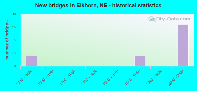
- New bridges - historical statistics
- 21930-1939
- 21980-1989
- 82000-2009
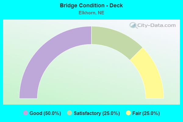
- Bridge Condition - Deck
- 50.0%Good
- 25.0%Satisfactory
- 25.0%Fair
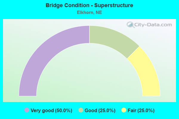
- Bridge Condition - Superstructure
- 50.0%Very good
- 25.0%Good
- 25.0%Fair
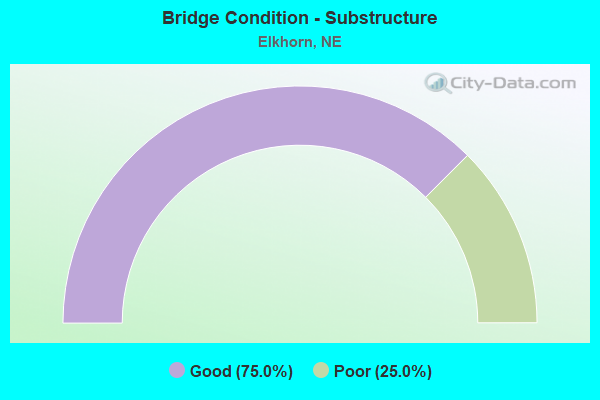
- Bridge Condition - Substructure
- 75.0%Good
- 25.0%Poor
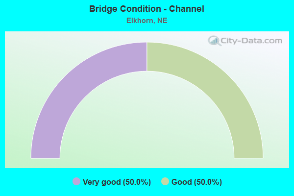
- Bridge Condition - Channel
- 50.0%Very good
- 50.0%Good
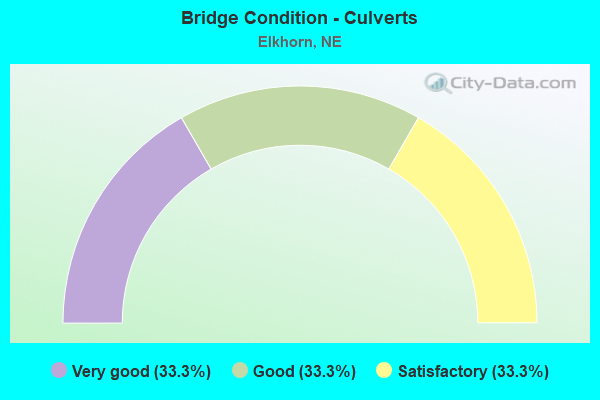
- Bridge Condition - Culverts
- 33.3%Very good
- 33.3%Good
- 33.3%Satisfactory
Find on map >> Show street view
Structure Number: S006 35693L, Location: US6/L28B/N31 INTCHG (Lat: 41.262900, Lng: -96.234400), Route carried "on" structure: US 6, Year Built: 2002, Status: Open, Structure Length: 6.34m (20.80ft), Average Daily Traffic: 27,910 (year 2018), Truck Traffic: 5%, Average Future Daily Traffic: 55,820 (year 2038), Features Intersected: N31
Minimum Vertical Clearance: 30+ m (98+ ft), Kilometerpoint: 57.442, Lanes on structure: 2, Lanes under structure: 2, Base Highway Network: Yes, Owner: State Highway Agency, Approaching Roadway Width: 16.5m (54.1ft), Material/Design: Prestressed concrete, Design/Construction: Stringer/Multi-beam, Number Of Spans In Main Unit: 1, Length of Maximum Span: 63.1m (207.0ft), Curb-To-Curb Width: 16.9m (55.4ft), Out-to-Out Width: 17.7m (58.1ft)
Condition: Deck: Good, Superstructure: Very good, Substructure: Good, Operating Rating: 90.0 metric tons, Method Used To Determine Operating Rating: Load Factor (LF), Inventory Rating: 45.0 metric tons, Method Used To Determine Inventory Rating: Load Factor (LF), Structural Evaluation: Better than present minimum criteria, Deck Geometry: Superior to present desirable criteria, Underclear: Better than present minimum criteria, Approach Roadway Alignment: Equal to present desirable criteria, Designated Inspection Frequency: Every 24 months, Inspection Date: March 2022, Deck Structure Type: Concrete Cast-file-Place, Wearing Surface/Protective System: Wearing Surface: Monolithic Concrete, Deck Protection: Epoxy Coated Reinforcing
Find on map >> Show street view
Structure Number: S006 35693R, Location: US6/L28B/N31 INTRCHG (Lat: 41.262700, Lng: -96.234400), Route carried "on" structure: US 6, Year Built: 2002, Status: Open, Structure Length: 6.34m (20.80ft), Average Daily Traffic: 27,910 (year 2018), Truck Traffic: 5%, Average Future Daily Traffic: 55,820 (year 2038), Features Intersected: N31
Minimum Vertical Clearance: 30+ m (98+ ft), Kilometerpoint: 57.442, Lanes on structure: 2, Lanes under structure: 2, Base Highway Network: Yes, Owner: State Highway Agency, Approaching Roadway Width: 16.5m (54.1ft), Material/Design: Prestressed concrete, Design/Construction: Stringer/Multi-beam, Number Of Spans In Main Unit: 1, Length of Maximum Span: 63.1m (207.0ft), Curb-To-Curb Width: 16.9m (55.4ft), Out-to-Out Width: 17.7m (58.1ft)
Condition: Deck: Good, Superstructure: Very good, Substructure: Good, Operating Rating: 90.0 metric tons, Method Used To Determine Operating Rating: Load Factor (LF), Inventory Rating: 45.0 metric tons, Method Used To Determine Inventory Rating: Load Factor (LF), Structural Evaluation: Better than present minimum criteria, Deck Geometry: Superior to present desirable criteria, Underclear: Better than present minimum criteria, Approach Roadway Alignment: Equal to present desirable criteria, Designated Inspection Frequency: Every 24 months, Inspection Date: March 2022, Deck Structure Type: Concrete Cast-file-Place, Wearing Surface/Protective System: Wearing Surface: Monolithic Concrete, Deck Protection: Other
Find on map >> Show street view
Structure Number: S006 35728, Location: .35E JCT US6/N31 (Lat: 41.262800, Lng: -96.227600), Route carried "on" structure: US 6, Year Built: 2002, Status: Open, Structure Length: 0.61m (2.00ft), Average Daily Traffic: 47,940 (year 2018), Truck Traffic: 5%, Average Future Daily Traffic: 95,880 (year 2038), Features Intersected: STREAM
Minimum Vertical Clearance: 30+ m (98+ ft), Kilometerpoint: 57.498, Lanes on structure: 4, Base Highway Network: Yes, Owner: State Highway Agency, Approaching Roadway Width: 16.5m (54.1ft), Material/Design: Concrete, Design/Construction: Culvert, Number Of Spans In Main Unit: 2, Length of Maximum Span: 3.0m (9.8ft)
Condition: Channel: Very good, Culverts: Very good, Operating Rating: 43.0 metric tons, Method Used To Determine Operating Rating: Field evaluation and documented engineering judgment, Inventory Rating: 33.0 metric tons, Method Used To Determine Inventory Rating: Field evaluation and documented engineering judgment, Structural Evaluation: Equal to present desirable criteria, Waterway Adequacy: Equal to present desirable criteria, Approach Roadway Alignment: Equal to present desirable criteria, Designated Inspection Frequency: Every 24 months, Inspection Date: March 2022
Find on map >> Show street view
Structure Number: S031 00616, Location: 8S GRETNA (Lat: 41.023300, Lng: -96.257300), Route carried "on" structure: State highway 31, Year Built: 1984, Status: Open, Structure Length: 1.46m (4.79ft), Average Daily Traffic: 1,625 (year 2018), Truck Traffic: 10%, Average Future Daily Traffic: 2,600 (year 2038), Features Intersected: STREAM
Minimum Vertical Clearance: 30+ m (98+ ft), Kilometerpoint: 0.991, Lanes on structure: 2, Owner: State Highway Agency, Approaching Roadway Width: 7.3m (24.0ft), Skew: 3 degrees, Material/Design: Concrete, Design/Construction: Culvert, Number Of Spans In Main Unit: 4, Length of Maximum Span: 3.0m (9.8ft)
Condition: Channel: Very good, Culverts: Good, Operating Rating: 43.0 metric tons, Method Used To Determine Operating Rating: Field evaluation and documented engineering judgment, Inventory Rating: 33.0 metric tons, Method Used To Determine Inventory Rating: Field evaluation and documented engineering judgment, Structural Evaluation: Better than present minimum criteria, Waterway Adequacy: Better than present minimum criteria, Approach Roadway Alignment: Equal to present desirable criteria, Designated Inspection Frequency: Every 24 months, Inspection Date: January 2022
Find on map >> Show street view
Structure Number: S031 0244, Location: IN ELKHORN (Lat: 41.281200, Lng: -96.234500), Route carried "on" structure: State highway 31, Year Built: 1938, Year Reconstructed: 1977, Status: Open, Structure Length: 15.70m (51.51ft), Average Daily Traffic: 11,100 (year 2018), Truck Traffic: 4%, Average Future Daily Traffic: 18,315 (year 2038), Features Intersected: PARK/PAPIO/UP 816-853-S
Minimum Vertical Clearance: 30+ m (98+ ft), Kilometerpoint: 3.927, Lanes on structure: 2, Lanes under structure: 2, Base Highway Network: Yes, Owner: State Highway Agency, Approaching Roadway Width: 13.4m (44.0ft), Skew: 1 degrees, Material/Design: Steel, Design/Construction: Stringer/Multi-beam, Number Of Spans In Main Unit: 10, Length of Maximum Span: 23.2m (76.1ft), Curb or Sidewalk Widths: Left: 1.9m (6.2ft), Right: 0.2m (0.7ft), Curb-To-Curb Width: 13.4m (44.0ft), Out-to-Out Width: 15.7m (51.5ft)
Condition: Deck: Fair, Superstructure: Fair, Substructure: Poor, Channel: Good, Operating Rating: 44.0 metric tons, Method Used To Determine Operating Rating: Load Factor (LF), Inventory Rating: 26.0 metric tons, Method Used To Determine Inventory Rating: Load Factor (LF), Structural Evaluation: Meets minimum limits, Deck Geometry: Equal to present minimum criteria, Underclear: Somewhat better than minimum adequacy, Waterway Adequacy: Equal to present desirable criteria, Approach Roadway Alignment: Equal to present desirable criteria, Designated Inspection Frequency: Every 24 months, Inspection Date: March 2020, Deck Structure Type: Concrete Cast-file-Place, Wearing Surface/Protective System: Wearing Surface: Monolithic Concrete, Deck Protection: Epoxy Coated Reinforcing
Find on map >> Show street view
Structure Number: S064 06169, Location: 1W ELKHORN (Lat: 41.292400, Lng: -96.252200), Route carried "on" structure: State highway 64, Year Built: 1981, Status: Open, Structure Length: 1.34m (4.40ft), Average Daily Traffic: 5,055 (year 2018), Truck Traffic: 7%, Average Future Daily Traffic: 9,099 (year 2038), Features Intersected: W BR PAPILLION CREEK
Minimum Vertical Clearance: 30+ m (98+ ft), Kilometerpoint: 9.928, Lanes on structure: 4, Base Highway Network: Yes, Owner: State Highway Agency, Approaching Roadway Width: 21.3m (69.9ft), Skew: 4 degrees, Material/Design: Concrete, Design/Construction: Culvert, Number Of Spans In Main Unit: 4, Length of Maximum Span: 2.4m (7.9ft)
Condition: Channel: Good, Culverts: Satisfactory, Operating Rating: 33.0 metric tons, Method Used To Determine Operating Rating: Field evaluation and documented engineering judgment, Inventory Rating: 22.0 metric tons, Method Used To Determine Inventory Rating: Field evaluation and documented engineering judgment, Structural Evaluation: Somewhat better than minimum adequacy, Waterway Adequacy: Equal to present desirable criteria, Approach Roadway Alignment: Equal to present desirable criteria, Designated Inspection Frequency: Every 24 months, Inspection Date: March 2020
Find on map >> Show street view
Structure Number: SL28B00216, Location: IN ELKORN (Lat: 41.263700, Lng: -96.254400), Route carried "on" structure: City street 5169, Year Built: 2002, Status: Open, Structure Length: 6.58m (21.59ft), Average Daily Traffic: 900 (year 2002), Average Future Daily Traffic: 990 (year 2033), Features Intersected: SL28B/W DODGE RD, Facility Carried by Structure: SKYLINE DRIVE
Minimum Vertical Clearance: 30+ m (98+ ft), Kilometerpoint: 16.410, Lanes on structure: 2, Lanes under structure: 5, Owner: State Highway Agency, Approaching Roadway Width: 11.6m (38.1ft), Skew: 2 degrees, Material/Design: Steel continuous, Design/Construction: Stringer/Multi-beam, Number Of Spans In Main Unit: 2, Length of Maximum Span: 38.1m (125.0ft), Curb or Sidewalk Widths: Left: 0.0m, Right: 3.0m (9.8ft), Curb-To-Curb Width: 11.6m (38.1ft), Out-to-Out Width: 15.7m (51.5ft)
Condition: Deck: Satisfactory, Superstructure: Good, Substructure: Good, Operating Rating: 60.0 metric tons, Method Used To Determine Operating Rating: Load Factor (LF), Inventory Rating: 35.0 metric tons, Method Used To Determine Inventory Rating: Load Factor (LF), Structural Evaluation: Better than present minimum criteria, Deck Geometry: Better than present minimum criteria, Underclear: Superior to present desirable criteria, Approach Roadway Alignment: Equal to present desirable criteria, Designated Inspection Frequency: Every 24 months, Inspection Date: March 2022, Deck Structure Type: Concrete Cast-file-Place, Wearing Surface/Protective System: Wearing Surface: Integral Concrete, Deck Protection: Epoxy Coated Reinforcing
Find on map >> Show street view
Structure Number: S006 35693L, Location: US6/L28B/N31 INTCHG (Lat: 41.262900, Lng: -96.234400), Route carried "under" structure: State highway 31, Year Built: 2002, Structure Length: 0. m, Average Daily Traffic: 24,990 (year 2012), Truck Traffic: 4%, Features Intersected: N31, Facility Carried by Structure: US6 WB
Minimum Vertical Clearance: 5.23m (17.16ft), Kilometerpoint: 3.719, Lanes on structure: 2, Lanes under structure: 2, Material/Design: Prestressed concrete, Design/Construction: Stringer/Multi-beam, Length of Maximum Span: 63.1m (207.0ft)
Find on map >> Show street view
Structure Number: S006 35693R, Location: US6/L28B/N31 INTRCHG (Lat: 41.262700, Lng: -96.234400), Route carried "under" structure: State highway 31, Year Built: 2002, Structure Length: 0. m, Average Daily Traffic: 24,990 (year 2012), Truck Traffic: 4%, Features Intersected: N31, Facility Carried by Structure: US6 EB
Minimum Vertical Clearance: 5.23m (17.16ft), Kilometerpoint: 3.719, Lanes on structure: 2, Lanes under structure: 2, Material/Design: Prestressed concrete, Design/Construction: Stringer/Multi-beam, Length of Maximum Span: 63.1m (207.0ft)
Find on map >> Show street view
Structure Number: S031 0244, Location: IN ELKHORN (Lat: 41.281200, Lng: -96.234500), Route carried "under" structure: City street L16, Year Built: 1938, Structure Length: 0. m, Average Daily Traffic: 930 (year 1998), Features Intersected: PARK/PAPIO/UP 816-853-S, Facility Carried by Structure: N31
Minimum Vertical Clearance: 6.80m (22.31ft), Kilometerpoint: 0.000, Lanes on structure: 2, Lanes under structure: 2, Material/Design: Steel, Design/Construction: Stringer/Multi-beam, Length of Maximum Span: 23.2m (76.1ft)
Find on map >> Show street view
Structure Number: SL28B00216, Location: IN ELKORN (Lat: 41.263700, Lng: -96.254400), Route carried "under" structure: State highway L28B, Year Built: 2002, Structure Length: 0. m, Average Daily Traffic: 5,910 (year 2002), Features Intersected: SL28B/W DODGE RD, Facility Carried by Structure: SKYLINE DRIVE
Minimum Vertical Clearance: 5.33m (17.49ft), Kilometerpoint: 0.348, Lanes on structure: 5, Lanes under structure: 5, Material/Design: Steel continuous, Design/Construction: Stringer/Multi-beam, Length of Maximum Span: 38.1m (125.0ft)
Find on map >> Show street view
Structure Number: SL28B00216, Location: IN ELKORN (Lat: 41.263700, Lng: -96.254400), Route carried "under" structure: Ramp State highway 5169, Year Built: 2002, Structure Length: 0. m, Average Daily Traffic: 5,910 (year 2002), Features Intersected: SL28B/W DODGE RD, Facility Carried by Structure: SKYLINE DRIVE
Minimum Vertical Clearance: 5.33m (17.49ft), Kilometerpoint: 16.407, Lanes on structure: 5, Lanes under structure: 5, Material/Design: Steel continuous, Design/Construction: Stringer/Multi-beam, Length of Maximum Span: 38.1m (125.0ft)