Bridge Statistics for Elizabethtown, Illinois (IL)
Condition, Traffic, Stress, Structural Evaluation, Project Costs
- National Bridge Inventory (NBI) Statistics
- 14Number of bridges
- 112ft / 34.0mTotal length
- 6,575Total average daily traffic
- 1,272Total average daily truck traffic
- 9,525Total future (year 2032) average daily traffic
- National Bridge Inventory (NBI) Registered Bridges for Elizabethtown
- No street view available for this location
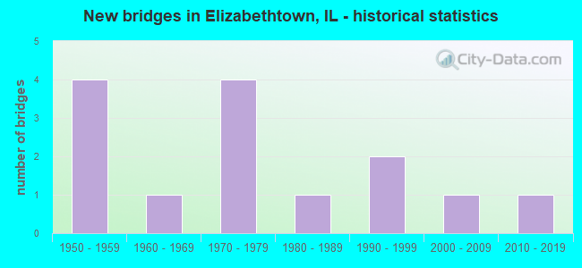
- New bridges - historical statistics
- 41950-1959
- 11960-1969
- 41970-1979
- 11980-1989
- 21990-1999
- 12000-2009
- 12010-2019


- Bridge Condition - Deck
- 25.0%Very good
- 50.0%Good
- 25.0%Poor

- Bridge Condition - Superstructure
- 25.0%Very good
- 50.0%Good
- 12.5%Satisfactory
- 12.5%Fair

- Bridge Condition - Substructure
- 37.5%Very good
- 25.0%Good
- 25.0%Satisfactory
- 12.5%Fair

- Bridge Condition - Channel
- 21.4%Very good
- 35.7%Good
- 14.3%Satisfactory
- 21.4%Fair
- 7.1%Serious

- Bridge Condition - Culverts
- 16.7%Very good
- 50.0%Good
- 33.3%Satisfactory
Find on map >> Show street view
Structure Number: 350011, Location: 1 MI E ELIZABETHTOWN (Lat: 37.465467, Lng: -88.291869), Route carried "on" structure: State highway 146, Year Built: 1953, Status: Open, Structure Length: 3.94m (12.93ft), Average Daily Traffic: 1,500 (year 2021), Truck Traffic: 32%, Average Future Daily Traffic: 1,800 (year 2032), Design Load: HS 20, Features Intersected: HOSICK CREEK
Minimum Vertical Clearance: 30+ m (98+ ft), Kilometerpoint: 137.627, Lanes on structure: 2, Base Highway Network: Yes, Owner: State Highway Agency, Approaching Roadway Width: 12.8m (42.0ft), Material/Design: Steel continuous, Design/Construction: Stringer/Multi-beam, Number Of Spans In Main Unit: 3, Length of Maximum Span: 14.9m (48.9ft), Curb or Sidewalk Widths: Left: 0.5m (1.6ft), Right: 0.5m (1.6ft), Curb-To-Curb Width: 8.5m (27.9ft), Out-to-Out Width: 10.3m (33.8ft)
Condition: Deck: Poor, Superstructure: Satisfactory, Substructure: Satisfactory, Channel: Satisfactory, Operating Rating: 61.2 metric tons, Method Used To Determine Operating Rating: Load Factor (LF) rating reported by rating factor (RF) method using MS18 loading, Inventory Rating: 36.6 metric tons, Method Used To Determine Inventory Rating: Load Factor (LF) rating reported by rating factor (RF) method using MS18 loading, Structural Evaluation: Equal to present minimum criteria, Deck Geometry: Somewhat better than minimum adequacy, Waterway Adequacy: Better than present minimum criteria, Approach Roadway Alignment: Equal to present desirable criteria, Designated Inspection Frequency: Every 24 months, Inspection Date: Febuary 2022, Deck Structure Type: Concrete Cast-file-Place, Wearing Surface/Protective System: Wearing Surface: Other
Find on map >> Show street view
Structure Number: 350014, Location: WEST CORP E'TOWN (Lat: 37.444722, Lng: -88.318242), Route carried "on" structure: State highway 146, Year Built: 2004, Status: Open, Structure Length: 11.58m (37.99ft), Average Daily Traffic: 2,100 (year 2021), Truck Traffic: 7%, Average Future Daily Traffic: 2,850 (year 2032), Design Load: HS 20, Features Intersected: BIG CREEK
Minimum Vertical Clearance: 30+ m (98+ ft), Kilometerpoint: 133.862, Lanes on structure: 2, Base Highway Network: Yes, Owner: State Highway Agency, Approaching Roadway Width: 7.3m (24.0ft), Material/Design: Steel continuous, Design/Construction: Stringer/Multi-beam, Number Of Spans In Main Unit: 3, Length of Maximum Span: 44.5m (146.0ft), Curb-To-Curb Width: 11.0m (36.1ft), Out-to-Out Width: 11.9m (39.0ft)
Condition: Deck: Very good, Superstructure: Very good, Substructure: Very good, Channel: Very good, Operating Rating: 67.1 metric tons, Method Used To Determine Operating Rating: Load Factor (LF) rating reported by rating factor (RF) method using MS18 loading, Inventory Rating: 40.5 metric tons, Method Used To Determine Inventory Rating: Load Factor (LF) rating reported by rating factor (RF) method using MS18 loading, Structural Evaluation: Equal to present desirable criteria, Deck Geometry: Somewhat better than minimum adequacy, Waterway Adequacy: Superior to present desirable criteria, Approach Roadway Alignment: Equal to present desirable criteria, Designated Inspection Frequency: Every 24 months, Inspection Date: March 2021, Deck Structure Type: Concrete Cast-file-Place, Wearing Surface/Protective System: Deck Protection: Epoxy Coated Reinforcing
Find on map >> Show street view
Structure Number: 352002, Location: 1.7M N OF E-TOWN (Lat: 37.474428, Lng: -88.280914), Route carried "on" structure: State highway 146, Year Built: 1954, Status: Open, Structure Length: 0.66m (2.17ft), Average Daily Traffic: 1,500 (year 2021), Truck Traffic: 32%, Average Future Daily Traffic: 1,800 (year 2032), Design Load: HS 20, Features Intersected: STREAM
Minimum Vertical Clearance: 30+ m (98+ ft), Kilometerpoint: 139.044, Lanes on structure: 2, Base Highway Network: Yes, Owner: State Highway Agency, Approaching Roadway Width: 7.3m (24.0ft), Skew: 3 degrees, Material/Design: Concrete continuous, Design/Construction: Culvert, Number Of Spans In Main Unit: 2, Length of Maximum Span: 3.4m (11.2ft)
Condition: Channel: Satisfactory, Culverts: Good, Operating Rating: 89.1 metric tons, Method Used To Determine Operating Rating: Load Factor (LF) rating reported by rating factor (RF) method using MS18 loading, Inventory Rating: 82.0 metric tons, Method Used To Determine Inventory Rating: Load Factor (LF) rating reported by rating factor (RF) method using MS18 loading, Structural Evaluation: Better than present minimum criteria, Waterway Adequacy: Equal to present minimum criteria, Approach Roadway Alignment: Equal to present desirable criteria, Designated Inspection Frequency: Every 24 months, Inspection Date: January 2021
Find on map >> Show street view
Structure Number: 353024, Location: 1.5 MI NE E'TOWN (Lat: 37.466508, Lng: -88.279825), Route carried "on" structure: County highway , Year Built: 1978, Status: Open, Structure Length: 0.67m (2.20ft), Average Daily Traffic: 125 (year 2018), Truck Traffic: 8%, Average Future Daily Traffic: 225 (year 2032), Design Load: HS 20, Features Intersected: BRANCH HOSICK CK, Facility Carried by Structure: TR 101
Minimum Vertical Clearance: 30+ m (98+ ft), Kilometerpoint: 0.917, Lanes on structure: 2, Owner: Town or Township Highway Agency, Approaching Roadway Width: 8.5m (27.9ft), Material/Design: Concrete, Design/Construction: Culvert, Number Of Spans In Main Unit: 2, Length of Maximum Span: 3.0m (9.8ft), Curb-To-Curb Width: 7.3m (24.0ft), Out-to-Out Width: 8.7m (28.5ft)
Condition: Channel: Good, Culverts: Satisfactory, Operating Rating: 44.4 metric tons, Method Used To Determine Operating Rating: Assigned rating based on Load Factor Design (LFD) reported by rating factor (RF) using MS18 loading, Inventory Rating: 32.4 metric tons, Method Used To Determine Inventory Rating: Assigned rating based on Load Factor Design (LFD) reported by rating factor (RF) using MS18 loading, Structural Evaluation: Equal to present minimum criteria, Deck Geometry: Somewhat better than minimum adequacy, Waterway Adequacy: Equal to present desirable criteria, Approach Roadway Alignment: Superior to present desirable criteria, Designated Inspection Frequency: Every 24 months, Inspection Date: October 2021
Find on map >> Show street view
Structure Number: 353025, Location: 4.50 MI E ST RTE 34 (Lat: 37.496686, Lng: -88.332036), Route carried "on" structure: County highway , Year Built: 1979, Status: Open, Structure Length: 1.86m (6.10ft), Average Daily Traffic: 125 (year 2018), Truck Traffic: 9%, Average Future Daily Traffic: 125 (year 2032), Design Load: HS 20, Features Intersected: GOOSE CREEK, Facility Carried by Structure: CH 12
Minimum Vertical Clearance: 30+ m (98+ ft), Kilometerpoint: 12.955, Lanes on structure: 2, Owner: County Highway Agency, Approaching Roadway Width: 8.5m (27.9ft), Skew: 1 degrees, Material/Design: Concrete, Design/Construction: Channel Beam, Number Of Spans In Main Unit: 3, Length of Maximum Span: 6.1m (20.0ft), Curb-To-Curb Width: 8.0m (26.2ft), Out-to-Out Width: 8.0m (26.2ft)
Condition: Deck: Good, Superstructure: Good, Substructure: Good, Channel: Fair, Operating Rating: 44.4 metric tons, Method Used To Determine Operating Rating: Assigned rating based on Load Factor Design (LFD) reported by rating factor (RF) using MS18 loading, Inventory Rating: 32.4 metric tons, Method Used To Determine Inventory Rating: Assigned rating based on Load Factor Design (LFD) reported by rating factor (RF) using MS18 loading, Structural Evaluation: Better than present minimum criteria, Deck Geometry: Somewhat better than minimum adequacy, Waterway Adequacy: Equal to present desirable criteria, Approach Roadway Alignment: Equal to present desirable criteria, Designated Inspection Frequency: Every 48 months, Inspection Date: September 2021, Deck Structure Type: Concrete Precast Panels, Wearing Surface/Protective System: Wearing Surface: Gravel
Find on map >> Show street view
Structure Number: 353038, Location: 3.75 MI N OF E.TOWN (Lat: 37.510189, Lng: -88.287500), Route carried "on" structure: County highway , Year Built: 1986, Status: Open, Structure Length: 1.40m (4.59ft), Average Daily Traffic: 50 (year 2018), Truck Traffic: 20%, Average Future Daily Traffic: 125 (year 2032), Design Load: HS 20, Features Intersected: TRIB TO HOGTHIEF CR, Facility Carried by Structure: TR 5A
Minimum Vertical Clearance: 30+ m (98+ ft), Kilometerpoint: 14.162, Lanes on structure: 2, Owner: Town or Township Highway Agency, Approaching Roadway Width: 6.1m (20.0ft), Material/Design: Prestressed concrete, Design/Construction: Box Beam or Girders - Multiple, Number Of Spans In Main Unit: 1, Length of Maximum Span: 13.4m (44.0ft), Curb-To-Curb Width: 7.4m (24.3ft), Out-to-Out Width: 7.4m (24.3ft)
Condition: Deck: Good, Superstructure: Good, Substructure: Very good, Channel: Good, Operating Rating: 44.4 metric tons, Method Used To Determine Operating Rating: Assigned rating based on Load Factor Design (LFD) reported by rating factor (RF) using MS18 loading, Inventory Rating: 32.4 metric tons, Method Used To Determine Inventory Rating: Assigned rating based on Load Factor Design (LFD) reported by rating factor (RF) using MS18 loading, Structural Evaluation: Better than present minimum criteria, Deck Geometry: Equal to present minimum criteria, Waterway Adequacy: Equal to present desirable criteria, Approach Roadway Alignment: Better than present minimum criteria, Designated Inspection Frequency: Every 48 months, Inspection Date: October 2021, Deck Structure Type: Concrete Precast Panels, Wearing Surface/Protective System: Wearing Surface: Gravel
Find on map >> Show street view
Structure Number: 353039, Location: 3 MI N ELIZABETHTOWN (Lat: 37.497411, Lng: -88.315131), Route carried "on" structure: County highway , Year Built: 1991, Status: Open, Structure Length: 3.09m (10.14ft), Average Daily Traffic: 75 (year 2018), Truck Traffic: 43%, Average Future Daily Traffic: 50 (year 2032), Design Load: HS 20, Features Intersected: HOGTHIEF CREEK, Facility Carried by Structure: TR 52A
Minimum Vertical Clearance: 30+ m (98+ ft), Kilometerpoint: 0.257, Lanes on structure: 2, Owner: Town or Township Highway Agency, Approaching Roadway Width: 4.9m (16.1ft), Skew: 3 degrees, Material/Design: Wood or Timber, Design/Construction: Stringer/Multi-beam, Number Of Spans In Main Unit: 3, Length of Maximum Span: 12.1m (39.7ft), Curb-To-Curb Width: 7.3m (24.0ft), Out-to-Out Width: 7.9m (25.9ft)
Condition: Deck: Good, Superstructure: Good, Substructure: Satisfactory, Channel: Very good, Operating Rating: 44.4 metric tons, Method Used To Determine Operating Rating: Assigned rating based on Load Factor Design (LFD) reported by rating factor (RF) using MS18 loading, Inventory Rating: 32.4 metric tons, Method Used To Determine Inventory Rating: Assigned rating based on Load Factor Design (LFD) reported by rating factor (RF) using MS18 loading, Structural Evaluation: Equal to present minimum criteria, Deck Geometry: Equal to present minimum criteria, Waterway Adequacy: Equal to present desirable criteria, Approach Roadway Alignment: Equal to present minimum criteria, Designated Inspection Frequency: Every 24 months, Inspection Date: October 2021, Deck Structure Type: Wood or Timber, Wearing Surface/Protective System: Wearing Surface: Gravel
Find on map >> Show street view
Structure Number: 35304, Location: 3.5M N ELIZABETHTOWN (Lat: 37.503117, Lng: -88.299381), Route carried "on" structure: County highway , Year Built: 1991, Status: Open, Structure Length: 2.96m (9.71ft), Average Daily Traffic: 150 (year 2018), Truck Traffic: 13%, Average Future Daily Traffic: 500 (year 2032), Design Load: HS 20, Features Intersected: HOGTHIEF CREEK, Facility Carried by Structure: FAS 1934
Minimum Vertical Clearance: 30+ m (98+ ft), Kilometerpoint: 0.097, Lanes on structure: 2, Owner: County Highway Agency, Approaching Roadway Width: 8.5m (27.9ft), Skew: 4 degrees, Material/Design: Prestressed concrete, Design/Construction: Box Beam or Girders - Multiple, Number Of Spans In Main Unit: 1, Number Of Approach Spans: 1, Length of Maximum Span: 18.0m (59.1ft), Curb-To-Curb Width: 9.2m (30.2ft), Out-to-Out Width: 9.2m (30.2ft)
Condition: Deck: Good, Superstructure: Good, Substructure: Good, Channel: Good, Operating Rating: 44.4 metric tons, Method Used To Determine Operating Rating: Assigned rating based on Load Factor Design (LFD) reported by rating factor (RF) using MS18 loading, Inventory Rating: 32.4 metric tons, Method Used To Determine Inventory Rating: Assigned rating based on Load Factor Design (LFD) reported by rating factor (RF) using MS18 loading, Structural Evaluation: Better than present minimum criteria, Deck Geometry: Equal to present minimum criteria, Waterway Adequacy: Equal to present minimum criteria, Approach Roadway Alignment: Better than present minimum criteria, Designated Inspection Frequency: Every 48 months, Inspection Date: September 2021, Deck Structure Type: Concrete Precast Panels, Wearing Surface/Protective System: Wearing Surface: Bituminous
Find on map >> Show street view
Structure Number: 353057, Location: 1 MI NE OF E'TOWN (Lat: 37.467028, Lng: -88.294983), Route carried "on" structure: County highway , Year Built: 2019, Status: Open, Structure Length: 2.19m (7.19ft), Average Daily Traffic: 150 (year 2018), Truck Traffic: 16%, Average Future Daily Traffic: 300 (year 2032), Design Load: HS 25 or greater, Features Intersected: HOSICK CREEK, Facility Carried by Structure: BASSET SCHOOL RD
Minimum Vertical Clearance: 30+ m (98+ ft), Kilometerpoint: 0.274, Lanes on structure: 2, Owner: Town or Township Highway Agency, Approaching Roadway Width: 5.5m (18.0ft), Skew: 2 degrees, Material/Design: Prestressed concrete, Design/Construction: Stringer/Multi-beam, Number Of Spans In Main Unit: 1, Length of Maximum Span: 21.1m (69.2ft), Curb-To-Curb Width: 7.3m (24.0ft), Out-to-Out Width: 7.3m (24.0ft)
Condition: Deck: Very good, Superstructure: Very good, Substructure: Very good, Channel: Very good, Operating Rating: 63.2 metric tons, Method Used To Determine Operating Rating: Load and Resistance Factor Rating (LRFR) rating reported by rating factor(RF) method using HL-93 loadings, Inventory Rating: 48.6 metric tons, Method Used To Determine Inventory Rating: Load and Resistance Factor Rating (LRFR) rating reported by rating factor(RF) method using HL-93 loadings, Structural Evaluation: Equal to present desirable criteria, Deck Geometry: Somewhat better than minimum adequacy, Waterway Adequacy: Equal to present desirable criteria, Approach Roadway Alignment: Equal to present desirable criteria, Designated Inspection Frequency: Every 48 months, Inspection Date: April 2021, Deck Structure Type: Concrete Precast Panels
Find on map >> Show street view
Structure Number: 355003, Location: 2.3 MI N OF HWY 146 (Lat: 37.484114, Lng: -88.344694), Route carried "on" structure: County highway , Year Built: 1974, Status: Open, Structure Length: 0.73m (2.40ft), Average Daily Traffic: 200 (year 2021), Truck Traffic: 5%, Average Future Daily Traffic: 300 (year 2032), Design Load: HS 15, Features Intersected: BR OF BIG CREEK, Facility Carried by Structure: FAS 2934
Minimum Vertical Clearance: 30+ m (98+ ft), Kilometerpoint: 15.047, Lanes on structure: 2, Owner: County Highway Agency, Approaching Roadway Width: 9.1m (29.9ft), Material/Design: Concrete, Design/Construction: Culvert, Number Of Spans In Main Unit: 2, Length of Maximum Span: 3.4m (11.2ft)
Condition: Channel: Good, Culverts: Good, Operating Rating: 40.5 metric tons, Method Used To Determine Operating Rating: Field evaluation and documented engineering judgment, Inventory Rating: 24.3 metric tons, Method Used To Determine Inventory Rating: Field evaluation and documented engineering judgment, Structural Evaluation: Equal to present minimum criteria, Waterway Adequacy: Equal to present desirable criteria, Approach Roadway Alignment: Equal to present desirable criteria, Designated Inspection Frequency: Every 48 months, Inspection Date: October 2019
Find on map >> Show street view
Structure Number: 355004, Location: 2.5 MI N OF HWY 146 (Lat: 37.486442, Lng: -88.342511), Route carried "on" structure: County highway , Year Built: 1974, Status: Open, Structure Length: 0.98m (3.22ft), Average Daily Traffic: 200 (year 2021), Truck Traffic: 5%, Average Future Daily Traffic: 300 (year 2032), Design Load: HS 15, Features Intersected: BR OF BIG CREEK, Facility Carried by Structure: FAS 2934
Minimum Vertical Clearance: 30+ m (98+ ft), Kilometerpoint: 14.709, Lanes on structure: 2, Owner: County Highway Agency, Approaching Roadway Width: 9.1m (29.9ft), Material/Design: Concrete, Design/Construction: Culvert, Number Of Spans In Main Unit: 3, Length of Maximum Span: 3.0m (9.8ft)
Condition: Channel: Good, Culverts: Very good, Operating Rating: 40.5 metric tons, Method Used To Determine Operating Rating: Field evaluation and documented engineering judgment, Inventory Rating: 24.3 metric tons, Method Used To Determine Inventory Rating: Field evaluation and documented engineering judgment, Structural Evaluation: Equal to present minimum criteria, Waterway Adequacy: Superior to present desirable criteria, Approach Roadway Alignment: Equal to present desirable criteria, Designated Inspection Frequency: Every 48 months, Inspection Date: October 2019
Find on map >> Show street view
Structure Number: 355005, Location: 3 MI NORTHE'TOWN (Lat: 37.499350, Lng: -88.294744), Route carried "on" structure: County highway , Year Built: 1955, Status: Open, Structure Length: 0.82m (2.69ft), Average Daily Traffic: 150 (year 2018), Truck Traffic: 13%, Average Future Daily Traffic: 500 (year 2032), Design Load: H 15, Features Intersected: STREAM, Facility Carried by Structure: FAS 1934
Minimum Vertical Clearance: 30+ m (98+ ft), Kilometerpoint: 0.724, Lanes on structure: 2, Owner: County Highway Agency, Approaching Roadway Width: 9.1m (29.9ft), Skew: 3 degrees, Material/Design: Concrete, Design/Construction: Culvert, Number Of Spans In Main Unit: 2, Length of Maximum Span: 3.7m (12.1ft)
Condition: Channel: Fair, Culverts: Satisfactory, Operating Rating: 40.5 metric tons, Method Used To Determine Operating Rating: Field evaluation and documented engineering judgment, Inventory Rating: 24.3 metric tons, Method Used To Determine Inventory Rating: Field evaluation and documented engineering judgment, Structural Evaluation: Equal to present minimum criteria, Waterway Adequacy: Better than present minimum criteria, Approach Roadway Alignment: Equal to present desirable criteria, Designated Inspection Frequency: Every 24 months, Inspection Date: October 2021
Find on map >> Show street view
Structure Number: 355006, Location: 1.5 MI NORTH E'TOWN (Lat: 37.477781, Lng: -88.299694), Route carried "on" structure: County highway , Year Built: 1955, Status: Open, Structure Length: 0.66m (2.17ft), Average Daily Traffic: 150 (year 2018), Truck Traffic: 13%, Average Future Daily Traffic: 500 (year 2032), Design Load: H 15, Features Intersected: HOSICK CK, Facility Carried by Structure: FAS 1934
Minimum Vertical Clearance: 30+ m (98+ ft), Kilometerpoint: 3.460, Lanes on structure: 2, Owner: County Highway Agency, Approaching Roadway Width: 9.1m (29.9ft), Material/Design: Concrete, Design/Construction: Culvert, Number Of Spans In Main Unit: 2, Length of Maximum Span: 3.0m (9.8ft)
Condition: Channel: Fair, Culverts: Good, Operating Rating: 40.5 metric tons, Method Used To Determine Operating Rating: Field evaluation and documented engineering judgment, Inventory Rating: 24.3 metric tons, Method Used To Determine Inventory Rating: Field evaluation and documented engineering judgment, Structural Evaluation: Equal to present minimum criteria, Waterway Adequacy: Equal to present desirable criteria, Approach Roadway Alignment: Equal to present desirable criteria, Designated Inspection Frequency: Every 24 months, Inspection Date: October 2021
Find on map >> Show street view
Structure Number: 90801000001005, Location: 3.5 M N E'TOWN (Lat: 37.498122, Lng: -88.327692), Route carried "on" structure: Federal lands road 141, Year Built: 1968, Year Reconstructed: 1, Status: Open, Structure Length: 2.44m (8.01ft), Average Daily Traffic: 100 (year 1993), Truck Traffic: 1%, Average Future Daily Traffic: 150 (year 2042), Features Intersected: BIG CREEK
Minimum Vertical Clearance: 30+ m (98+ ft), Kilometerpoint: 6.080, Lanes on structure: 2, Owner: U.S. Forest Service, Approaching Roadway Width: 7.3m (24.0ft), Material/Design: Steel, Design/Construction: Stringer/Multi-beam, Number Of Spans In Main Unit: 1, Length of Maximum Span: 24.1m (79.1ft), Curb or Sidewalk Widths: Left: 0.3m (1.0ft), Right: 0.3m (1.0ft), Curb-To-Curb Width: 7.3m (24.0ft), Out-to-Out Width: 7.9m (25.9ft)
Condition: Deck: Poor, Superstructure: Fair, Substructure: Fair, Channel: Serious, Operating Rating: 48.6 metric tons, Method Used To Determine Operating Rating: Load and Resistance Factor Rating (LRFR) rating reported by rating factor(RF) method using HL-93 loadings, Inventory Rating: 35.6 metric tons, Method Used To Determine Inventory Rating: Load and Resistance Factor Rating (LRFR) rating reported by rating factor(RF) method using HL-93 loadings, Structural Evaluation: Somewhat better than minimum adequacy, Deck Geometry: Equal to present minimum criteria, Waterway Adequacy: Equal to present desirable criteria, Approach Roadway Alignment: Equal to present minimum criteria, Designated Inspection Frequency: Every 24 months, Inspection Date: April 2021, Deck Structure Type: Wood or Timber, Wearing Surface/Protective System: Wearing Surface: Bituminous