Bridge Statistics for Elizabeth, Pennsylvania (PA)
Condition, Traffic, Stress, Structural Evaluation, Project Costs
- National Bridge Inventory (NBI) Statistics
- 10Number of bridges
- 259ft / 79.4mTotal length
- $9,953,000Total costs
- 126,296Total average daily traffic
- 10,892Total average daily truck traffic
- National Bridge Inventory (NBI) Registered Bridges for Elizabeth
- No street view available for this location
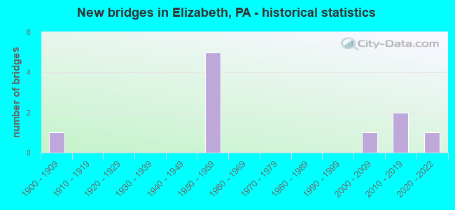
- New bridges - historical statistics
- 11900-1909
- 51950-1959
- 12000-2009
- 22010-2019
- 12020-2022

- Reconstructed bridges - Historical Statistics
- 21980-1989
- 01990-1999
- 02000-2009
- 02010-2019
- 12020-2022


- Bridge Condition - Superstructure
- 33.3%Very good
- 33.3%Satisfactory
- 33.3%Fair

- Bridge Condition - Substructure
- 66.7%Good
- 16.7%Satisfactory
- 16.7%Poor

- Bridge Condition - Channel
- 33.3%Very good
- 33.3%Satisfactory
- 16.7%Fair
- 16.7%Poor
Find on map >> Show street view
Structure Number: 712, Location: Elizabeth Bridge (Lat: 40.271928, Lng: -79.884897), Route carried "on" structure: State highway 51, Year Built: 1951, Year Reconstructed: 2020, Status: Open, Structure Length: 45.78m (150.20ft), Average Daily Traffic: 24,747 (year 2022), Truck Traffic: 7%, Average Future Daily Traffic: 33,630 (year 2032), Design Load: HS 20, Features Intersected: SR837 2001 CSX NS MON RI, Facility Carried by Structure: Elizabeth Bridge
Minimum Vertical Clearance: 6.00m (19.69ft), Kilometerpoint: 8.673, Lanes on structure: 4, Lanes under structure: 8, Base Highway Network: Yes, Owner: State Highway Agency, Approaching Roadway Width: 16.2m (53.1ft), Skew: 30 degrees, Navigation Control: Yes ( Vertical Clearance: 538.0m (1,765.1ft), Horizontal Clearance: 484.3m (1,588.9ft)), Material/Design: Steel continuous, Design/Construction: Truss - Thru, Number Of Spans In Main Unit: 3, Number Of Approach Spans: 13, Length of Maximum Span: 137.2m (450.1ft), Curb or Sidewalk Widths: Left: 2.2m (7.2ft), Right: 0.0m, Curb-To-Curb Width: 16.3m (53.5ft), Out-to-Out Width: 17.4m (57.1ft)
Condition: Deck: Good, Superstructure: Fair, Substructure: Satisfactory, Channel: Fair, Operating Rating: 71.7 metric tons, Method Used To Determine Operating Rating: Load Factor (LF), Inventory Rating: 41.7 metric tons, Method Used To Determine Inventory Rating: Load Factor (LF), Structural Evaluation: Somewhat better than minimum adequacy, Deck Geometry: Meets minimum limits, Underclear: High priority of corrective action, Waterway Adequacy: Superior to present desirable criteria, Approach Roadway Alignment: Somewhat better than minimum adequacy, Length Of Structure Improvement: 69.00m (226.38ft), Designated Inspection Frequency: Every 24 months, Critical Feature Inspection Frequency: Every 12 months, Underwater Inspection Frequency: Every 60 months, Inspection Date: April 2021, Critical Feature Inspection Date: April 2021, Underwater Inspection Date: August 2019, Bridge Improvement Cost: $725,000, Roadway Improvement Cost: $2,135,000, Total Project Cost: $9,788,000, Deck Structure Type: Closed Grating, Wearing Surface/Protective System: Wearing Surface: Monolithic Concrete
Find on map >> Show street view
Structure Number: 1484, Location: NEAR LOVEDALE RD (Lat: 40.279625, Lng: -79.874517), Route carried "on" structure: State highway , Year Built: 1905, Status: Open, Structure Length: 1.52m (4.99ft), Average Daily Traffic: 5,506 (year 2022), Truck Traffic: 5%, Average Future Daily Traffic: 8,382 (year 2032), Design Load: HS 20, Features Intersected: WYLIE RUN, Facility Carried by Structure: GLASSPORT ROAD
Minimum Vertical Clearance: 30+ m (98+ ft), Kilometerpoint: 15.994, Lanes on structure: 2, Owner: State Highway Agency, Approaching Roadway Width: 7.9m (25.9ft), Material/Design: Masonry, Design/Construction: Arch - Deck, Number Of Spans In Main Unit: 1, Length of Maximum Span: 8.5m (27.9ft), Curb-To-Curb Width: 6.4m (21.0ft), Out-to-Out Width: 7.3m (24.0ft)
Condition: Superstructure: Fair, Substructure: Poor, Channel: Poor, Operating Rating: 49.0 metric tons, Method Used To Determine Operating Rating: Field evaluation and documented engineering judgment, Inventory Rating: 32.7 metric tons, Method Used To Determine Inventory Rating: Field evaluation and documented engineering judgment, Structural Evaluation: Meets minimum limits, Deck Geometry: High priority of replacement, Waterway Adequacy: Equal to present desirable criteria, Approach Roadway Alignment: Better than present minimum criteria, Length Of Structure Improvement: 2.20m (7.22ft), Designated Inspection Frequency: Every 24 months, Other Special Inspection Frequency: Every 12 months, Inspection Date: March 2021, Other Special Inspection Date: March 2021, Bridge Improvement Cost: $12,000, Roadway Improvement Cost: $36,000, Total Project Cost: $165,000, Deck Structure Type: Concrete Cast-file-Place, Wearing Surface/Protective System: Wearing Surface: Bituminous
Find on map >> Show street view
Structure Number: 45328, Location: Elizabeth Bridge (Lat: 40.272917, Lng: -79.890611), Route carried "on" structure: State highway 51, Year Built: 1951, Year Reconstructed: 1985, Status: Open, Structure Length: 14.87m (48.79ft), Average Daily Traffic: 12,636 (year 2022), Truck Traffic: 8%, Average Future Daily Traffic: 17,171 (year 2032), Design Load: HS 20, Features Intersected: SR 837, NSRR, Local Rd.
Minimum Vertical Clearance: 30+ m (98+ ft), Kilometerpoint: 8.673, Lanes on structure: 2, Lanes under structure: 4, Base Highway Network: Yes, Owner: State Highway Agency, Approaching Roadway Width: 8.5m (27.9ft), Skew: 19 degrees, Material/Design: Steel, Design/Construction: Stringer/Multi-beam, Number Of Spans In Main Unit: 7, Number Of Approach Spans: 1, Length of Maximum Span: 23.5m (77.1ft), Curb or Sidewalk Widths: Left: 0.2m (0.7ft), Right: 0.2m (0.7ft), Curb-To-Curb Width: 8.5m (27.9ft), Out-to-Out Width: 9.6m (31.5ft)
Condition: Deck: Good, Superstructure: Satisfactory, Substructure: Good, Operating Rating: 89.8 metric tons, Method Used To Determine Operating Rating: Load Factor (LF), Inventory Rating: 53.5 metric tons, Method Used To Determine Inventory Rating: Load Factor (LF), Structural Evaluation: Equal to present minimum criteria, Deck Geometry: High priority of corrective action, Underclear: Equal to present minimum criteria, Approach Roadway Alignment: Equal to present minimum criteria, Designated Inspection Frequency: Every 24 months, Inspection Date: April 2021, Deck Structure Type: Concrete Cast-file-Place, Wearing Surface/Protective System: Wearing Surface: Latex Concrete, Deck Protection: Epoxy Coated Reinforcing
Find on map >> Show street view
Structure Number: 45329, Location: Elizabeth Bridge (Lat: 40.272778, Lng: -79.885556), Route carried "on" structure: State highway 51, Year Built: 1951, Year Reconstructed: 1985, Status: Open, Structure Length: 13.47m (44.19ft), Average Daily Traffic: 12,111 (year 2022), Truck Traffic: 6%, Average Future Daily Traffic: 16,459 (year 2032), Design Load: HS 20, Features Intersected: NSSR, Local Rd.
Minimum Vertical Clearance: 30+ m (98+ ft), Kilometerpoint: 8.673, Lanes on structure: 2, Lanes under structure: 2, Base Highway Network: Yes, Owner: State Highway Agency, Approaching Roadway Width: 8.5m (27.9ft), Skew: 10 degrees, Material/Design: Steel, Design/Construction: Stringer/Multi-beam, Number Of Spans In Main Unit: 8, Length of Maximum Span: 20.7m (67.9ft), Curb or Sidewalk Widths: Left: 2.7m (8.9ft), Right: 0.2m (0.7ft), Curb-To-Curb Width: 8.5m (27.9ft), Out-to-Out Width: 9.8m (32.2ft)
Condition: Deck: Good, Superstructure: Satisfactory, Substructure: Good, Operating Rating: 97.1 metric tons, Method Used To Determine Operating Rating: Load Factor (LF), Inventory Rating: 58.1 metric tons, Method Used To Determine Inventory Rating: Load Factor (LF), Structural Evaluation: Equal to present minimum criteria, Deck Geometry: High priority of corrective action, Underclear: High priority of corrective action, Approach Roadway Alignment: Somewhat better than minimum adequacy, Designated Inspection Frequency: Every 24 months, Inspection Date: April 2021, Deck Structure Type: Concrete Cast-file-Place, Wearing Surface/Protective System: Wearing Surface: Latex Concrete
Find on map >> Show street view
Structure Number: 45723, Location: 750' NW WEIGEL HILL RD (Lat: 40.264328, Lng: -79.878464), Route carried "on" structure: State highway 51, Year Built: 2009, Status: Open, Structure Length: 1.10m (3.61ft), Average Daily Traffic: 26,308 (year 2022), Truck Traffic: 14%, Average Future Daily Traffic: 24,510 (year 2032), Design Load: HS 20, Features Intersected: FALLEN TIMBER RUN
Minimum Vertical Clearance: 30+ m (98+ ft), Kilometerpoint: 7.501, Lanes on structure: 2, Base Highway Network: Yes, Owner: State Highway Agency, Approaching Roadway Width: 19.5m (64.0ft), Skew: 34 degrees, Material/Design: Prestressed concrete, Design/Construction: Box Beam or Girders - Single/Spread, Number Of Spans In Main Unit: 1, Length of Maximum Span: 10.4m (34.1ft), Curb-To-Curb Width: 19.5m (64.0ft), Out-to-Out Width: 21.1m (69.2ft)
Condition: Deck: Good, Superstructure: Very good, Substructure: Good, Channel: Satisfactory, Operating Rating: 75.3 metric tons, Method Used To Determine Operating Rating: Load Factor (LF), Inventory Rating: 37.2 metric tons, Method Used To Determine Inventory Rating: Load Factor (LF), Structural Evaluation: Better than present minimum criteria, Deck Geometry: Superior to present desirable criteria, Waterway Adequacy: Equal to present minimum criteria, Approach Roadway Alignment: Equal to present desirable criteria, Designated Inspection Frequency: Every 24 months, Inspection Date: December 2019, Deck Structure Type: Concrete Cast-file-Place, Wearing Surface/Protective System: Wearing Surface: Latex Concrete, Deck Protection: Epoxy Coated Reinforcing
Find on map >> Show street view
Structure Number: 46046, Location: ELIZABETH (Lat: 40.279314, Lng: -79.852136), Route carried "on" structure: State highway , Year Built: 2010, Status: Open, Structure Length: 0.94m (3.08ft), Average Daily Traffic: 6,943 (year 2022), Truck Traffic: 3%, Average Future Daily Traffic: 8,997 (year 2032), Design Load: HL 93, Features Intersected: OVER BRANCH OF WYLIE RUN, Facility Carried by Structure: LOVEDALE ROAD
Minimum Vertical Clearance: 30+ m (98+ ft), Kilometerpoint: 1.986, Lanes on structure: 2, Owner: State Highway Agency, Approaching Roadway Width: 9.1m (29.9ft), Skew: 4 degrees, Material/Design: Steel, Design/Construction: Stringer/Multi-beam, Number Of Spans In Main Unit: 1, Length of Maximum Span: 9.1m (29.9ft), Curb-To-Curb Width: 9.1m (29.9ft), Out-to-Out Width: 10.1m (33.1ft)
Condition: Deck: Good, Superstructure: Very good, Substructure: Good, Channel: Very good, Inventory Rating: 85.3 metric tons, Method Used To Determine Inventory Rating: Load Factor (LF), Structural Evaluation: Better than present minimum criteria, Deck Geometry: High priority of corrective action, Waterway Adequacy: Superior to present desirable criteria, Approach Roadway Alignment: Somewhat better than minimum adequacy, Designated Inspection Frequency: Every 24 months, Inspection Date: January 2020, Deck Structure Type: Concrete Cast-file-Place, Wearing Surface/Protective System: Wearing Surface: Monolithic Concrete, Deck Protection: Epoxy Coated Reinforcing
Find on map >> Show street view
Structure Number: 54105, Location: @ INTER.W/WEIGLE HILL RD. (Lat: 40.262642, Lng: -79.878217), Route carried "on" structure: State highway 51, Year Built: 2018, Status: Open, Structure Length: 0.98m (3.22ft), Average Daily Traffic: 18,052 (year 2022), Truck Traffic: 5%, Average Future Daily Traffic: 25,458 (year 2039), Design Load: HL 93, Features Intersected: FALLEN TIMBER RUN
Minimum Vertical Clearance: 30+ m (98+ ft), Kilometerpoint: 6.650, Lanes on structure: 5, Base Highway Network: Yes, Owner: State Highway Agency, Maintenance Responsibility: Private, Approaching Roadway Width: 21.9m (71.9ft), Skew: 24 degrees, Material/Design: Concrete, Design/Construction: Culvert, Number Of Spans In Main Unit: 1, Length of Maximum Span: 8.8m (28.9ft), Curb-To-Curb Width: 21.9m (71.9ft), Out-to-Out Width: 29.3m (96.1ft)
Condition: Channel: Satisfactory, Culverts: Very good, Operating Rating: 71.6 metric tons, Method Used To Determine Operating Rating: Assigned ratings based on Load and Resistance Factor Design (LRFD) reported by rating factor (RF) using HL93 loadings, Inventory Rating: 45.0 metric tons, Method Used To Determine Inventory Rating: Assigned ratings based on Load and Resistance Factor Design (LRFD) reported by rating factor (RF) using HL93 loadings, Structural Evaluation: Equal to present desirable criteria, Deck Geometry: Somewhat better than minimum adequacy, Waterway Adequacy: Superior to present desirable criteria, Approach Roadway Alignment: Equal to present desirable criteria, Designated Inspection Frequency: Every 24 months, Inspection Date: November 2021, Wearing Surface/Protective System: Wearing Surface: Bituminous, Membrane: Preformed Fabric
Find on map >> Show street view
Structure Number: 54484, Location: 500' East of SR 51 (Lat: 40.274400, Lng: -79.883917), Route carried "on" structure: State highway , Year Built: 2020, Status: Open, Structure Length: 0.76m (2.49ft), Average Daily Traffic: 9,990 (year 2021), Truck Traffic: 9%, Average Future Daily Traffic: 15,819 (year 2032), Design Load: HL 93, Features Intersected: Fallen Timber Run, Facility Carried by Structure: Center Ave.
Minimum Vertical Clearance: 30+ m (98+ ft), Kilometerpoint: 14.954, Lanes on structure: 2, Owner: State Highway Agency, Approaching Roadway Width: 7.3m (24.0ft), Skew: 9 degrees, Material/Design: Concrete, Design/Construction: Culvert, Number Of Spans In Main Unit: 1, Length of Maximum Span: 7.0m (23.0ft), Curb-To-Curb Width: 7.9m (25.9ft), Out-to-Out Width: 8.8m (28.9ft)
Condition: Channel: Very good, Culverts: Very good, Operating Rating: 47.6 metric tons, Method Used To Determine Operating Rating: Assigned ratings based on Load and Resistance Factor Design (LRFD) reported by rating factor (RF) using HL93 loadings, Inventory Rating: 36.6 metric tons, Method Used To Determine Inventory Rating: Assigned ratings based on Load and Resistance Factor Design (LRFD) reported by rating factor (RF) using HL93 loadings, Structural Evaluation: Equal to present desirable criteria, Deck Geometry: High priority of replacement, Waterway Adequacy: Superior to present desirable criteria, Approach Roadway Alignment: Equal to present desirable criteria, Designated Inspection Frequency: Every 24 months, Inspection Date: October 2020
Find on map >> Show street view
Structure Number: 712, Location: Elizabeth Bridge (Lat: 40.271928, Lng: -79.884897), Route carried "under" structure: State highway , Year Built: 1951, Structure Length: 0. m, Average Daily Traffic: 2,132 (year 2020), Truck Traffic: 13%, Features Intersected: SR837 2001 CSX NS MON RI, Facility Carried by Structure: Elizabeth Bridge
Minimum Vertical Clearance: 30+ m (98+ ft), Kilometerpoint: 14.666, Lanes on structure: 4, Lanes under structure: 2, Material/Design: Steel continuous, Design/Construction: Truss - Thru, Length of Maximum Span: 137.2m (450.1ft)
Find on map >> Show street view
Structure Number: 45328, Location: Elizabeth Bridge (Lat: 40.272917, Lng: -79.890611), Route carried "under" structure: State highway 837, Year Built: 1951, Structure Length: 0. m, Average Daily Traffic: 7,871 (year 2022), Truck Traffic: 15%, Features Intersected: SR 837, NSRR, Local Rd., Facility Carried by Structure: SR 51 North Bound
Minimum Vertical Clearance: 4.54m (14.90ft), Kilometerpoint: 3.463, Lanes on structure: 2, Lanes under structure: 2, Material/Design: Steel, Design/Construction: Stringer/Multi-beam, Length of Maximum Span: 23.5m (77.1ft)