Bridge Statistics for Elgin, Texas (TX)
Condition, Traffic, Stress, Structural Evaluation, Project Costs
- National Bridge Inventory (NBI) Statistics
- 35Number of bridges
- 203ft / 62.1mTotal length
- $536,000Total costs
- 218,422Total average daily traffic
- 21,782Total average daily truck traffic
- National Bridge Inventory (NBI) Registered Bridges for Elgin
- No street view available for this location
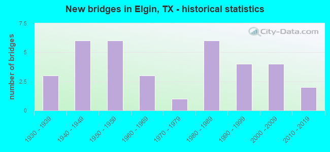
- New bridges - historical statistics
- 31930-1939
- 61940-1949
- 61950-1959
- 31960-1969
- 11970-1979
- 61980-1989
- 41990-1999
- 42000-2009
- 22010-2019
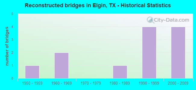
- Reconstructed bridges - Historical Statistics
- 11950-1959
- 21960-1969
- 01970-1979
- 11980-1989
- 41990-1999
- 42000-2009
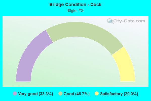
- Bridge Condition - Deck
- 33.3%Very good
- 46.7%Good
- 20.0%Satisfactory
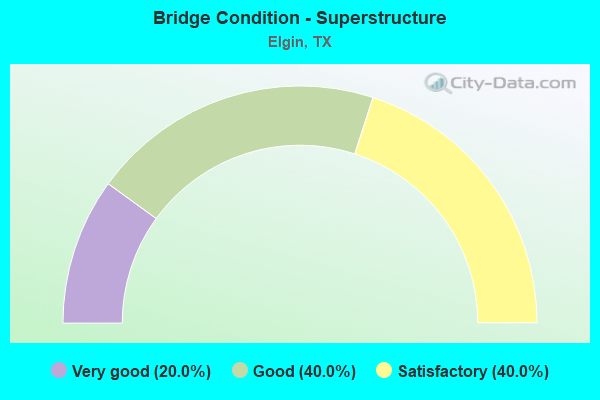
- Bridge Condition - Superstructure
- 20.0%Very good
- 40.0%Good
- 40.0%Satisfactory
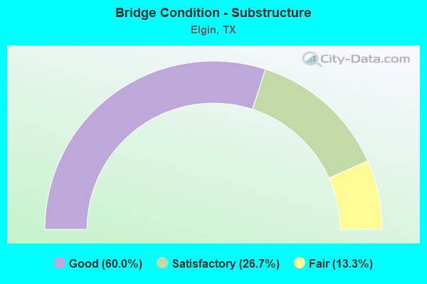
- Bridge Condition - Substructure
- 60.0%Good
- 26.7%Satisfactory
- 13.3%Fair
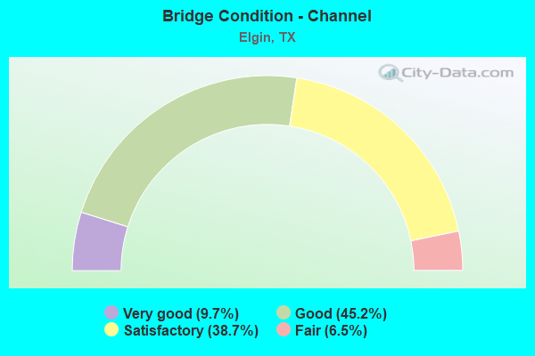
- Bridge Condition - Channel
- 9.7%Very good
- 45.2%Good
- 38.7%Satisfactory
- 6.5%Fair
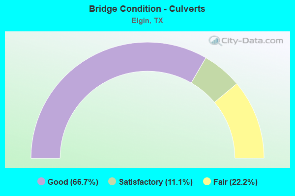
- Bridge Condition - Culverts
- 66.7%Good
- 11.1%Satisfactory
- 22.2%Fair
Find on map >> Show street view
Structure Number: 140110011404062, Location: 4.9 MI W OF FM 969 (Lat: 30.341425, Lng: -97.376978), Route carried "on" structure: US 290, Year Built: 1940, Year Reconstructed: 1969, Status: Open, Structure Length: 0.88m (2.89ft), Average Daily Traffic: 26,617 (year 2020), Truck Traffic: 14%, Average Future Daily Traffic: 34,390 (year 2033), Design Load: H 15, Features Intersected: SHARP CREEK
Minimum Vertical Clearance: 30+ m (98+ ft), Kilometerpoint: 3.640, Lanes on structure: 5, Owner: State Highway Agency, Approaching Roadway Width: 30.5m (100.1ft), Skew: 4 degrees, Material/Design: Concrete, Design/Construction: Culvert, Number Of Spans In Main Unit: 3, Length of Maximum Span: 1.8m (5.9ft)
Condition: Channel: Good, Culverts: Good, Operating Rating: 39.9 metric tons, Method Used To Determine Operating Rating: Load Factor (LF), Inventory Rating: 23.6 metric tons, Method Used To Determine Inventory Rating: Load Factor (LF), Structural Evaluation: Somewhat better than minimum adequacy, Waterway Adequacy: Equal to present minimum criteria, Approach Roadway Alignment: Equal to present desirable criteria, Designated Inspection Frequency: Every 24 months, Inspection Date: March 2021
Find on map >> Show street view
Structure Number: 140110011404067, Location: 1.0 MI W OF FM 1704 (Lat: 30.345156, Lng: -97.380614), Route carried "on" structure: US 290, Year Built: 1941, Year Reconstructed: 1969, Status: Open, Structure Length: 10.97m (35.99ft), Average Daily Traffic: 28,878 (year 2020), Truck Traffic: 14%, Average Future Daily Traffic: 37,300 (year 2033), Design Load: H 15, Features Intersected: UPRR & CENTRAL AVE
Minimum Vertical Clearance: 30+ m (98+ ft), Kilometerpoint: 3.011, Lanes on structure: 5, Lanes under structure: 2, Owner: State Highway Agency, Approaching Roadway Width: 29.3m (96.1ft), Skew: 9 degrees, Material/Design: Steel, Design/Construction: Stringer/Multi-beam, Number Of Spans In Main Unit: 6, Length of Maximum Span: 18.3m (60.0ft), Curb-To-Curb Width: 30.4m (99.7ft), Out-to-Out Width: 31.1m (102.0ft)
Condition: Deck: Satisfactory, Superstructure: Satisfactory, Substructure: Satisfactory, Operating Rating: 47.2 metric tons, Method Used To Determine Operating Rating: Load Factor (LF), Inventory Rating: 26.3 metric tons, Method Used To Determine Inventory Rating: Load Factor (LF), Structural Evaluation: Equal to present minimum criteria, Deck Geometry: Superior to present desirable criteria, Underclear: Somewhat better than minimum adequacy, Approach Roadway Alignment: Equal to present desirable criteria, Length Of Structure Improvement: 10.97m (35.99ft), Designated Inspection Frequency: Every 24 months, Inspection Date: March 2021, Deck Structure Type: Concrete Cast-file-Place
Find on map >> Show street view
Structure Number: 140110011404069, Location: 0.1 MI E OF SH 95 (Lat: 30.334069, Lng: -97.358206), Route carried "on" structure: US 290, Year Built: 1941, Year Reconstructed: 2006, Status: Open, Structure Length: 1.19m (3.90ft), Average Daily Traffic: 18,019 (year 2020), Truck Traffic: 12%, Average Future Daily Traffic: 21,440 (year 2033), Design Load: H 15, Features Intersected: OAK CREEK
Minimum Vertical Clearance: 30+ m (98+ ft), Kilometerpoint: 5.536, Lanes on structure: 5, Owner: State Highway Agency, Approaching Roadway Width: 24.4m (80.1ft), Skew: 10 degrees, Material/Design: Concrete, Design/Construction: Culvert, Number Of Spans In Main Unit: 4, Length of Maximum Span: 2.4m (7.9ft)
Condition: Channel: Good, Culverts: Good, Operating Rating: 39.9 metric tons, Method Used To Determine Operating Rating: Load Factor (LF), Inventory Rating: 23.6 metric tons, Method Used To Determine Inventory Rating: Load Factor (LF), Structural Evaluation: Somewhat better than minimum adequacy, Waterway Adequacy: Superior to present desirable criteria, Approach Roadway Alignment: Equal to present desirable criteria, Length Of Structure Improvement: 1.04m (3.41ft), Designated Inspection Frequency: Every 24 months, Inspection Date: March 2021, Bridge Improvement Cost: $3,000, Roadway Improvement Cost: $1,000, Total Project Cost: $4,000
Find on map >> Show street view
Structure Number: 14011001140413, Location: 0.2 MI E OF LP 109 (Lat: 30.336319, Lng: -97.366958), Route carried "on" structure: State highway 1704, Year Built: 1986, Status: Open, Structure Length: 3.90m (12.80ft), Average Daily Traffic: 3,120 (year 2013), Truck Traffic: 11%, Average Future Daily Traffic: 4,370 (year 2033), Design Load: HS 20, Features Intersected: US 290
Minimum Vertical Clearance: 30+ m (98+ ft), Kilometerpoint: 0.536, Lanes on structure: 2, Lanes under structure: 4, Owner: State Highway Agency, Approaching Roadway Width: 8.5m (27.9ft), Material/Design: Prestressed concrete, Design/Construction: Stringer/Multi-beam, Number Of Spans In Main Unit: 1, Number Of Approach Spans: 1, Length of Maximum Span: 28.7m (94.2ft), Curb-To-Curb Width: 12.1m (39.7ft), Out-to-Out Width: 12.8m (42.0ft)
Condition: Deck: Good, Superstructure: Good, Substructure: Good, Operating Rating: 68.0 metric tons, Method Used To Determine Operating Rating: Load Factor (LF), Inventory Rating: 40.8 metric tons, Method Used To Determine Inventory Rating: Load Factor (LF), Structural Evaluation: Better than present minimum criteria, Deck Geometry: Somewhat better than minimum adequacy, Underclear: Equal to present minimum criteria, Approach Roadway Alignment: Equal to present desirable criteria, Designated Inspection Frequency: Every 24 months, Inspection Date: March 2021, Deck Structure Type: Concrete Precast Panels, Wearing Surface/Protective System: Wearing Surface: Monolithic Concrete
Find on map >> Show street view
Structure Number: 140110011404142, Location: 1.0 MI W OF SH 95 (Lat: 30.351967, Lng: -97.402722), Route carried "on" structure: US 290, Year Built: 1994, Status: Open, Structure Length: 3.05m (10.01ft), Average Daily Traffic: 13,705 (year 2020), Truck Traffic: 7%, Average Future Daily Traffic: 17,100 (year 2033), Design Load: HS 20, Features Intersected: ELM CREEK
Minimum Vertical Clearance: 30+ m (98+ ft), Kilometerpoint: 0.637, Lanes on structure: 2, Owner: State Highway Agency, Approaching Roadway Width: 11.6m (38.1ft), Skew: 3 degrees, Material/Design: Prestressed concrete, Design/Construction: Stringer/Multi-beam, Number Of Spans In Main Unit: 2, Length of Maximum Span: 15.2m (49.9ft), Curb-To-Curb Width: 11.3m (37.1ft), Out-to-Out Width: 12.2m (40.0ft)
Condition: Deck: Good, Superstructure: Very good, Substructure: Good, Channel: Good, Operating Rating: 58.0 metric tons, Method Used To Determine Operating Rating: Load Factor (LF), Inventory Rating: 35.4 metric tons, Method Used To Determine Inventory Rating: Load Factor (LF), Structural Evaluation: Better than present minimum criteria, Deck Geometry: Equal to present minimum criteria, Waterway Adequacy: Superior to present desirable criteria, Approach Roadway Alignment: Equal to present desirable criteria, Designated Inspection Frequency: Every 24 months, Inspection Date: March 2021, Deck Structure Type: Concrete Precast Panels, Wearing Surface/Protective System: Wearing Surface: Bituminous
Find on map >> Show street view
Structure Number: 140110032103019, Location: 0.05 MI SE OF SH 95 (Lat: 30.356283, Lng: -97.382692), Route carried "on" structure: State highway 1100, Year Built: 1997, Status: Open, Structure Length: 1.13m (3.71ft), Average Daily Traffic: 3,346 (year 2020), Truck Traffic: 10%, Average Future Daily Traffic: 4,670 (year 2033), Features Intersected: DRAW
Minimum Vertical Clearance: 30+ m (98+ ft), Kilometerpoint: 6.566, Lanes on structure: 2, Owner: State Highway Agency, Approaching Roadway Width: 12.2m (40.0ft), Skew: 4 degrees, Material/Design: Concrete, Design/Construction: Culvert, Number Of Spans In Main Unit: 3, Length of Maximum Span: 2.4m (7.9ft), Curb-To-Curb Width: 12.2m (40.0ft), Out-to-Out Width: 17.8m (58.4ft)
Condition: Channel: Good, Culverts: Good, Operating Rating: 32.7 metric tons, Method Used To Determine Operating Rating: Field evaluation and documented engineering judgment, Inventory Rating: 24.5 metric tons, Method Used To Determine Inventory Rating: Field evaluation and documented engineering judgment, Structural Evaluation: Equal to present minimum criteria, Deck Geometry: Equal to present minimum criteria, Waterway Adequacy: Better than present minimum criteria, Approach Roadway Alignment: Equal to present desirable criteria, Designated Inspection Frequency: Every 24 months, Inspection Date: March 2021, Deck Structure Type: Concrete Cast-file-Place, Wearing Surface/Protective System: Wearing Surface: Bituminous
Find on map >> Show street view
Structure Number: 140110032201001, Location: 0.5 MI S OF US 290 (Lat: 30.326731, Lng: -97.360450), Route carried "on" structure: State highway 95, Year Built: 1938, Year Reconstructed: 2003, Status: Open, Structure Length: 1.04m (3.41ft), Average Daily Traffic: 9,277 (year 2020), Truck Traffic: 8%, Average Future Daily Traffic: 13,790 (year 2033), Design Load: H 15, Features Intersected: DRAW
Minimum Vertical Clearance: 30+ m (98+ ft), Kilometerpoint: 0.798, Lanes on structure: 2, Owner: State Highway Agency, Approaching Roadway Width: 14.6m (47.9ft), Material/Design: Concrete, Design/Construction: Culvert, Number Of Spans In Main Unit: 6, Length of Maximum Span: 1.5m (4.9ft)
Condition: Channel: Very good, Culverts: Satisfactory, Operating Rating: 39.9 metric tons, Method Used To Determine Operating Rating: Load Factor (LF), Inventory Rating: 23.6 metric tons, Method Used To Determine Inventory Rating: Load Factor (LF), Structural Evaluation: Somewhat better than minimum adequacy, Waterway Adequacy: Equal to present minimum criteria, Approach Roadway Alignment: Equal to present desirable criteria, Designated Inspection Frequency: Every 24 months, Inspection Date: March 2021
Find on map >> Show street view
Structure Number: 140110032201002, Location: 0.9 MI S OF US 290 (Lat: 30.321939, Lng: -97.357911), Route carried "on" structure: State highway 95, Year Built: 1938, Year Reconstructed: 2003, Status: Open, Structure Length: 0.82m (2.69ft), Average Daily Traffic: 10,317 (year 2020), Truck Traffic: 4%, Average Future Daily Traffic: 12,250 (year 2033), Design Load: H 15, Features Intersected: DRAW
Minimum Vertical Clearance: 30+ m (98+ ft), Kilometerpoint: 1.506, Lanes on structure: 2, Owner: State Highway Agency, Approaching Roadway Width: 14.6m (47.9ft), Material/Design: Concrete, Design/Construction: Culvert, Number Of Spans In Main Unit: 4, Length of Maximum Span: 1.8m (5.9ft)
Condition: Channel: Good, Culverts: Good, Operating Rating: 39.9 metric tons, Method Used To Determine Operating Rating: Load Factor (LF), Inventory Rating: 23.6 metric tons, Method Used To Determine Inventory Rating: Load Factor (LF), Structural Evaluation: Somewhat better than minimum adequacy, Waterway Adequacy: Equal to present minimum criteria, Approach Roadway Alignment: Equal to present desirable criteria, Designated Inspection Frequency: Every 24 months, Inspection Date: March 2021
Find on map >> Show street view
Structure Number: 140110123402002, Location: 1.0 MI W OF SH 95 (Lat: 30.362486, Lng: -97.398261), Route carried "on" structure: State highway 1100, Year Built: 1955, Year Reconstructed: 2013, Status: Open, Structure Length: 1.07m (3.51ft), Average Daily Traffic: 3,368 (year 2020), Truck Traffic: 23%, Average Future Daily Traffic: 6,950 (year 2033), Design Load: HS 20, Features Intersected: ELM CREEK
Minimum Vertical Clearance: 30+ m (98+ ft), Kilometerpoint: 0.439, Lanes on structure: 2, Owner: State Highway Agency, Approaching Roadway Width: 6.7m (22.0ft), Material/Design: Concrete, Design/Construction: Culvert, Number Of Spans In Main Unit: 4, Length of Maximum Span: 2.4m (7.9ft), Curb-To-Curb Width: 9.6m (31.5ft), Out-to-Out Width: 12.5m (41.0ft)
Condition: Channel: Satisfactory, Culverts: Good, Operating Rating: 39.9 metric tons, Method Used To Determine Operating Rating: Load Factor (LF), Inventory Rating: 23.6 metric tons, Method Used To Determine Inventory Rating: Load Factor (LF), Structural Evaluation: Equal to present minimum criteria, Deck Geometry: Meets minimum limits, Waterway Adequacy: Better than present minimum criteria, Approach Roadway Alignment: Equal to present desirable criteria, Length Of Structure Improvement: 1.07m (3.51ft), Designated Inspection Frequency: Every 24 months, Inspection Date: March 2021, Bridge Improvement Cost: $2,000, Roadway Improvement Cost: $1,000, Total Project Cost: $3,000, Deck Structure Type: Concrete Cast-file-Place, Wearing Surface/Protective System: Wearing Surface: Bituminous
Find on map >> Show street view
Structure Number: 140110153301001, Location: 1.8 MI S OF LP 109 (Lat: 30.316567, Lng: -97.378506), Route carried "on" structure: State highway 1704, Year Built: 1952, Year Reconstructed: 2013, Status: Open, Structure Length: 0.98m (3.22ft), Average Daily Traffic: 4,777 (year 2020), Truck Traffic: 11%, Average Future Daily Traffic: 4,180 (year 2033), Features Intersected: LITTLE SANDY CREEK
Minimum Vertical Clearance: 30+ m (98+ ft), Kilometerpoint: 3.024, Lanes on structure: 2, Owner: State Highway Agency, Approaching Roadway Width: 9.1m (29.9ft), Material/Design: Concrete, Design/Construction: Culvert, Number Of Spans In Main Unit: 3, Length of Maximum Span: 3.0m (9.8ft), Curb-To-Curb Width: 8.9m (29.2ft), Out-to-Out Width: 9.5m (31.2ft)
Condition: Channel: Good, Culverts: Good, Operating Rating: 39.9 metric tons, Method Used To Determine Operating Rating: Load Factor (LF), Inventory Rating: 23.6 metric tons, Method Used To Determine Inventory Rating: Load Factor (LF), Structural Evaluation: Equal to present minimum criteria, Deck Geometry: Meets minimum limits, Waterway Adequacy: Equal to present minimum criteria, Approach Roadway Alignment: Equal to present desirable criteria, Length Of Structure Improvement: 0.98m (3.22ft), Designated Inspection Frequency: Every 24 months, Inspection Date: March 2021, Bridge Improvement Cost: $2,000, Roadway Improvement Cost: $1,000, Total Project Cost: $3,000, Deck Structure Type: Concrete Cast-file-Place, Wearing Surface/Protective System: Wearing Surface: Bituminous
Find on map >> Show street view
Structure Number: 140110153301002, Location: 3.2 MI S OF LP 109 (Lat: 30.299167, Lng: -97.389564), Route carried "on" structure: State highway 1704, Year Built: 1952, Year Reconstructed: 2013, Status: Open, Structure Length: 0.67m (2.20ft), Average Daily Traffic: 4,777 (year 2020), Truck Traffic: 11%, Average Future Daily Traffic: 4,180 (year 2033), Features Intersected: DRAW
Minimum Vertical Clearance: 30+ m (98+ ft), Kilometerpoint: 5.248, Lanes on structure: 2, Owner: State Highway Agency, Approaching Roadway Width: 9.1m (29.9ft), Material/Design: Concrete, Design/Construction: Culvert, Number Of Spans In Main Unit: 2, Length of Maximum Span: 3.0m (9.8ft), Curb-To-Curb Width: 8.6m (28.2ft), Out-to-Out Width: 9.3m (30.5ft)
Condition: Channel: Good, Culverts: Good, Operating Rating: 39.9 metric tons, Method Used To Determine Operating Rating: Load Factor (LF), Inventory Rating: 23.6 metric tons, Method Used To Determine Inventory Rating: Load Factor (LF), Structural Evaluation: Equal to present minimum criteria, Deck Geometry: Meets minimum limits, Waterway Adequacy: Equal to present desirable criteria, Approach Roadway Alignment: Equal to present desirable criteria, Length Of Structure Improvement: 0.67m (2.20ft), Designated Inspection Frequency: Every 24 months, Inspection Date: March 2021, Bridge Improvement Cost: $1,000, Total Project Cost: $1,000, Deck Structure Type: Concrete Cast-file-Place, Wearing Surface/Protective System: Wearing Surface: Bituminous
Find on map >> Show street view
Structure Number: 140110311501001, Location: 1.2 MI E OF LP 109 (Lat: 30.356944, Lng: -97.352128), Route carried "on" structure: State highway 3000, Year Built: 1967, Status: Open, Structure Length: 0.91m (2.99ft), Average Daily Traffic: 2,236 (year 2020), Truck Traffic: 11%, Average Future Daily Traffic: 2,850 (year 2033), Design Load: HS 20, Features Intersected: BURLSON CREEK
Minimum Vertical Clearance: 30+ m (98+ ft), Kilometerpoint: 3.616, Lanes on structure: 2, Owner: State Highway Agency, Approaching Roadway Width: 7.3m (24.0ft), Skew: 3 degrees, Material/Design: Concrete, Design/Construction: Culvert, Number Of Spans In Main Unit: 3, Length of Maximum Span: 2.4m (7.9ft), Curb-To-Curb Width: 9.8m (32.2ft), Out-to-Out Width: 10.2m (33.5ft)
Condition: Channel: Satisfactory, Culverts: Fair, Operating Rating: 39.9 metric tons, Method Used To Determine Operating Rating: Load Factor (LF), Inventory Rating: 23.6 metric tons, Method Used To Determine Inventory Rating: Load Factor (LF), Structural Evaluation: Somewhat better than minimum adequacy, Deck Geometry: Meets minimum limits, Waterway Adequacy: Equal to present desirable criteria, Approach Roadway Alignment: Equal to present desirable criteria, Designated Inspection Frequency: Every 24 months, Inspection Date: March 2021, Deck Structure Type: Concrete Cast-file-Place, Wearing Surface/Protective System: Wearing Surface: Bituminous
Find on map >> Show street view
Structure Number: 140110311501002, Location: 3.1 MI E OF LP 109 (Lat: 30.362514, Lng: -97.323414), Route carried "on" structure: State highway 3000, Year Built: 1967, Status: Open, Structure Length: 2.87m (9.42ft), Average Daily Traffic: 727 (year 2020), Truck Traffic: 11%, Average Future Daily Traffic: 860 (year 2033), Design Load: H 20, Features Intersected: LITTLE SANDY CREEK
Minimum Vertical Clearance: 30+ m (98+ ft), Kilometerpoint: 6.645, Lanes on structure: 2, Owner: State Highway Agency, Approaching Roadway Width: 6.7m (22.0ft), Skew: 1 degrees, Material/Design: Concrete, Design/Construction: Stringer/Multi-beam, Number Of Spans In Main Unit: 3, Length of Maximum Span: 9.4m (30.8ft), Curb-To-Curb Width: 7.9m (25.9ft), Out-to-Out Width: 8.6m (28.2ft)
Condition: Deck: Good, Superstructure: Good, Substructure: Good, Channel: Good, Operating Rating: 61.7 metric tons, Method Used To Determine Operating Rating: Load Factor (LF), Inventory Rating: 37.2 metric tons, Method Used To Determine Inventory Rating: Load Factor (LF), Structural Evaluation: Better than present minimum criteria, Deck Geometry: Somewhat better than minimum adequacy, Waterway Adequacy: Equal to present minimum criteria, Approach Roadway Alignment: Equal to present desirable criteria, Designated Inspection Frequency: Every 24 months, Inspection Date: March 2021, Deck Structure Type: Concrete Cast-file-Place, Wearing Surface/Protective System: Wearing Surface: Bituminous
Find on map >> Show street view
Structure Number: 140110AA0052001, Location: 0.6 MI E OF FM 1704 (Lat: 30.301933, Lng: -97.377719), Route carried "on" structure: County highway 52, Year Built: 1987, Year Reconstructed: 1997, Status: Open, Structure Length: 0.94m (3.08ft), Average Daily Traffic: 177 (year 2010), Average Future Daily Traffic: 250 (year 2027), Features Intersected: LITTLE SANDY CREEK, Facility Carried by Structure: BEAVER RD
Minimum Vertical Clearance: 30+ m (98+ ft), Kilometerpoint: 0.966, Lanes on structure: 2, Owner: County Highway Agency, Approaching Roadway Width: 6.1m (20.0ft), Material/Design: Steel, Design/Construction: Stringer/Multi-beam, Number Of Spans In Main Unit: 1, Length of Maximum Span: 8.8m (28.9ft), Curb-To-Curb Width: 6.9m (22.6ft), Out-to-Out Width: 7.3m (24.0ft)
Condition: Deck: Very good, Superstructure: Satisfactory, Substructure: Satisfactory, Channel: Satisfactory, Operating Rating: 43.5 metric tons, Method Used To Determine Operating Rating: Allowable Stress (AS), Inventory Rating: 32.7 metric tons, Method Used To Determine Inventory Rating: Allowable Stress (AS), Structural Evaluation: Equal to present minimum criteria, Deck Geometry: Meets minimum limits, Waterway Adequacy: Meets minimum limits, Approach Roadway Alignment: Equal to present desirable criteria, Designated Inspection Frequency: Every 24 months, Inspection Date: November 2021, Deck Structure Type: Concrete Cast-file-Place, Wearing Surface/Protective System: Wearing Surface: Bituminous
Find on map >> Show street view
Structure Number: 140110AA0054001, Location: 0.85 MI SE OF FM 1704 (Lat: 30.286933, Lng: -97.380839), Route carried "on" structure: County highway 54, Year Built: 2009, Status: Open, Structure Length: 0.67m (2.20ft), Average Daily Traffic: 191 (year 2010), Average Future Daily Traffic: 250 (year 2027), Features Intersected: LITTLE SANDY CREEK, Facility Carried by Structure: ARBUCKLE RD
Minimum Vertical Clearance: 30+ m (98+ ft), Kilometerpoint: 1.368, Lanes on structure: 2, Owner: County Highway Agency, Approaching Roadway Width: 4.9m (16.1ft), Skew: 2 degrees, Material/Design: Concrete, Design/Construction: Culvert, Number Of Spans In Main Unit: 2, Length of Maximum Span: 3.0m (9.8ft), Curb-To-Curb Width: 6.9m (22.6ft), Out-to-Out Width: 7.3m (24.0ft)
Condition: Channel: Satisfactory, Culverts: Good, Operating Rating: 32.7 metric tons, Method Used To Determine Operating Rating: Field evaluation and documented engineering judgment, Inventory Rating: 24.5 metric tons, Method Used To Determine Inventory Rating: Field evaluation and documented engineering judgment, Structural Evaluation: Equal to present minimum criteria, Deck Geometry: Meets minimum limits, Waterway Adequacy: Better than present minimum criteria, Approach Roadway Alignment: Equal to present minimum criteria, Designated Inspection Frequency: Every 24 months, Inspection Date: November 2021, Deck Structure Type: Concrete Cast-file-Place, Wearing Surface/Protective System: Wearing Surface: Bituminous
Find on map >> Show street view
Structure Number: 140110AA0075001, Location: 0.2 MI SE OF LITTIG RD (Lat: 30.326125, Lng: -97.417356), Route carried "on" structure: County highway 75, Year Built: 2007, Status: Open, Structure Length: 0.76m (2.49ft), Average Daily Traffic: 536 (year 2020), Average Future Daily Traffic: 1,076 (year 2027), Features Intersected: WILBARGER CREEK TRIB, Facility Carried by Structure: MONKEY RD
Minimum Vertical Clearance: 30+ m (98+ ft), Kilometerpoint: 3.219, Lanes on structure: 2, Owner: County Highway Agency, Approaching Roadway Width: 5.2m (17.1ft), Skew: 1 degrees, Material/Design: Concrete, Design/Construction: Slab, Number Of Spans In Main Unit: 1, Length of Maximum Span: 7.0m (23.0ft), Curb-To-Curb Width: 6.9m (22.6ft), Out-to-Out Width: 7.3m (24.0ft)
Condition: Deck: Good, Superstructure: Good, Substructure: Good, Channel: Satisfactory, Operating Rating: 32.7 metric tons, Method Used To Determine Operating Rating: Field evaluation and documented engineering judgment, Inventory Rating: 24.5 metric tons, Method Used To Determine Inventory Rating: Field evaluation and documented engineering judgment, Structural Evaluation: Equal to present minimum criteria, Deck Geometry: Meets minimum limits, Waterway Adequacy: Better than present minimum criteria, Approach Roadway Alignment: Equal to present minimum criteria, Designated Inspection Frequency: Every 24 months, Inspection Date: November 2021, Deck Structure Type: Concrete Cast-file-Place, Wearing Surface/Protective System: Wearing Surface: Bituminous
Find on map >> Show street view
Structure Number: 140110AA0083001, Location: 0.9 MI NE OF LP 109 (Lat: 30.361611, Lng: -97.363578), Route carried "on" structure: County highway 83, Year Built: 1976, Year Reconstructed: 1997, Status: Open, Structure Length: 1.25m (4.10ft), Average Daily Traffic: 490 (year 2010), Truck Traffic: 1%, Average Future Daily Traffic: 676 (year 2027), Features Intersected: DRAW, Facility Carried by Structure: RED TOWN RD
Minimum Vertical Clearance: 30+ m (98+ ft), Kilometerpoint: 1.448, Lanes on structure: 2, Owner: County Highway Agency, Approaching Roadway Width: 6.1m (20.0ft), Material/Design: Steel continuous, Design/Construction: Stringer/Multi-beam, Number Of Spans In Main Unit: 2, Length of Maximum Span: 6.1m (20.0ft), Curb-To-Curb Width: 7.4m (24.3ft), Out-to-Out Width: 7.5m (24.6ft)
Condition: Deck: Good, Superstructure: Satisfactory, Substructure: Satisfactory, Channel: Satisfactory, Operating Rating: 32.7 metric tons, Method Used To Determine Operating Rating: Field evaluation and documented engineering judgment, Inventory Rating: 24.5 metric tons, Method Used To Determine Inventory Rating: Field evaluation and documented engineering judgment, Structural Evaluation: Equal to present minimum criteria, Deck Geometry: Meets minimum limits, Waterway Adequacy: Better than present minimum criteria, Approach Roadway Alignment: Equal to present desirable criteria, Designated Inspection Frequency: Every 24 months, Inspection Date: November 2021, Deck Structure Type: Concrete Cast-file-Place, Wearing Surface/Protective System: Wearing Surface: Bituminous
Find on map >> Show street view
Structure Number: 140110AA0083003, Location: 1.8 MI N OF ROEMER RD (Lat: 30.396453, Lng: -97.331461), Route carried "on" structure: County highway 83, Year Built: 1997, Status: Open, Structure Length: 2.13m (6.99ft), Average Daily Traffic: 490 (year 2010), Average Future Daily Traffic: 596 (year 2027), Features Intersected: LITTLE SANDY CREEK TRIB, Facility Carried by Structure: RED TOWN RD
Minimum Vertical Clearance: 30+ m (98+ ft), Kilometerpoint: 7.081, Lanes on structure: 2, Owner: County Highway Agency, Approaching Roadway Width: 5.5m (18.0ft), Material/Design: Concrete, Design/Construction: Stringer/Multi-beam, Number Of Spans In Main Unit: 2, Length of Maximum Span: 12.2m (40.0ft), Curb-To-Curb Width: 7.2m (23.6ft), Out-to-Out Width: 7.8m (25.6ft)
Condition: Deck: Good, Superstructure: Good, Substructure: Good, Channel: Satisfactory, Operating Rating: 32.7 metric tons, Method Used To Determine Operating Rating: Field evaluation and documented engineering judgment, Inventory Rating: 24.5 metric tons, Method Used To Determine Inventory Rating: Field evaluation and documented engineering judgment, Structural Evaluation: Equal to present minimum criteria, Deck Geometry: Meets minimum limits, Waterway Adequacy: Superior to present desirable criteria, Approach Roadway Alignment: Equal to present desirable criteria, Designated Inspection Frequency: Every 24 months, Inspection Date: November 2021, Deck Structure Type: Concrete Cast-file-Place, Wearing Surface/Protective System: Wearing Surface: Bituminous
Find on map >> Show street view
Structure Number: 140110AA0083004, Location: 1.59 MI NE OF FM 3000 (Lat: 30.380022, Lng: -97.330214), Route carried "on" structure: County highway 84, Year Built: 2012, Status: Open, Structure Length: 0.67m (2.20ft), Average Daily Traffic: 300 (year 2020), Truck Traffic: 1%, Average Future Daily Traffic: 500 (year 2040), Features Intersected: LITTLE SANDY CREEK
Minimum Vertical Clearance: 30+ m (98+ ft), Kilometerpoint: 2.012, Lanes on structure: 2, Owner: County Highway Agency, Approaching Roadway Width: 6.1m (20.0ft), Material/Design: Concrete, Design/Construction: Culvert, Number Of Spans In Main Unit: 2, Length of Maximum Span: 3.0m (9.8ft), Curb-To-Curb Width: 6.9m (22.6ft), Out-to-Out Width: 7.3m (24.0ft)
Condition: Channel: Good, Culverts: Good, Operating Rating: 32.7 metric tons, Method Used To Determine Operating Rating: Field evaluation and documented engineering judgment, Inventory Rating: 24.5 metric tons, Method Used To Determine Inventory Rating: Field evaluation and documented engineering judgment, Structural Evaluation: Equal to present minimum criteria, Deck Geometry: Meets minimum limits, Waterway Adequacy: Better than present minimum criteria, Approach Roadway Alignment: Equal to present desirable criteria, Designated Inspection Frequency: Every 24 months, Inspection Date: January 2020, Deck Structure Type: Concrete Cast-file-Place, Wearing Surface/Protective System: Wearing Surface: Monolithic Concrete
Find on map >> Show street view
Structure Number: 140110AA0084001, Location: 0.17 MI S OF CR 90 (Lat: 30.366111, Lng: -97.307436), Route carried "on" structure: County highway , Year Built: 2019, Status: Open, Structure Length: 1.31m (4.30ft), Average Daily Traffic: 100 (year 2020), Truck Traffic: 1%, Average Future Daily Traffic: 150 (year 2040), Design Load: HL 93, Features Intersected: LITTLE SANDY CREEK TRIB, Facility Carried by Structure: RACCOON ROAD
Minimum Vertical Clearance: 30+ m (98+ ft), Kilometerpoint: 0.274, Lanes on structure: 2, Owner: County Highway Agency, Approaching Roadway Width: 6.1m (20.0ft), Skew: 2 degrees, Material/Design: Concrete, Design/Construction: Culvert, Number Of Spans In Main Unit: 4, Length of Maximum Span: 2.4m (7.9ft), Curb-To-Curb Width: 6.9m (22.6ft), Out-to-Out Width: 7.3m (24.0ft)
Condition: Channel: Very good, Culverts: Good, Operating Rating: 54.4 metric tons, Method Used To Determine Operating Rating: Assigned ratings based on Load and Resistance Factor Design (LRFD) reported in metric tons, Inventory Rating: 32.7 metric tons, Method Used To Determine Inventory Rating: Assigned ratings based on Load and Resistance Factor Design (LRFD) reported in metric tons, Structural Evaluation: Better than present minimum criteria, Deck Geometry: Somewhat better than minimum adequacy, Waterway Adequacy: Better than present minimum criteria, Approach Roadway Alignment: Equal to present desirable criteria, Designated Inspection Frequency: Every 24 months, Inspection Date: January 2020, Deck Structure Type: Concrete Precast Panels, Wearing Surface/Protective System: Wearing Surface: Bituminous
Find on map >> Show street view
Structure Number: 140110AA1519001, Location: 0.50 MI NW OF SH 95 (Lat: 30.394597, Lng: -97.378419), Route carried "on" structure: County highway 87, Year Built: 1980, Status: Open, Structure Length: 0.91m (2.99ft), Average Daily Traffic: 100 (year 2020), Truck Traffic: 1%, Average Future Daily Traffic: 500 (year 2040), Design Load: HS 20, Features Intersected: DRY CREEK TRIBUTARY
Minimum Vertical Clearance: 30+ m (98+ ft), Kilometerpoint: 0.563, Lanes on structure: 2, Owner: County Highway Agency, Approaching Roadway Width: 5.5m (18.0ft), Material/Design: Steel, Design/Construction: Culvert, Number Of Spans In Main Unit: 4, Length of Maximum Span: 1.8m (5.9ft)
Condition: Channel: Good, Culverts: Good, Operating Rating: 54.4 metric tons, Method Used To Determine Operating Rating: Assigned rating based on Load Factor Design (LFD) reported in metric tons, Inventory Rating: 32.7 metric tons, Method Used To Determine Inventory Rating: Assigned rating based on Load Factor Design (LFD) reported in metric tons, Structural Evaluation: Better than present minimum criteria, Waterway Adequacy: Better than present minimum criteria, Approach Roadway Alignment: Equal to present desirable criteria, Designated Inspection Frequency: Every 24 months, Inspection Date: January 2020
Find on map >> Show street view
Structure Number: 142270011403059, Location: 3.15 MI W OF SH 95 (Lat: 30.351625, Lng: -97.437408), Route carried "on" structure: US 290, Year Built: 1940, Year Reconstructed: 1959, Status: Open, Structure Length: 3.05m (10.01ft), Average Daily Traffic: 13,873 (year 2020), Truck Traffic: 6%, Average Future Daily Traffic: 8,500 (year 2033), Design Load: H 15, Features Intersected: BIG DRY CREEK
Minimum Vertical Clearance: 30+ m (98+ ft), Kilometerpoint: 26.961, Lanes on structure: 2, Owner: State Highway Agency, Approaching Roadway Width: 13.4m (44.0ft), Skew: 3 degrees, Material/Design: Concrete, Design/Construction: Slab, Number Of Spans In Main Unit: 5, Length of Maximum Span: 6.1m (20.0ft), Curb-To-Curb Width: 13.9m (45.6ft), Out-to-Out Width: 14.8m (48.6ft)
Condition: Deck: Satisfactory, Superstructure: Satisfactory, Substructure: Fair, Channel: Good, Operating Rating: 32.7 metric tons, Method Used To Determine Operating Rating: Load Factor (LF), Inventory Rating: 19.0 metric tons, Method Used To Determine Inventory Rating: Load and Resistance Factor (LRFR), Structural Evaluation: Meets minimum limits, Deck Geometry: Superior to present desirable criteria, Waterway Adequacy: Equal to present minimum criteria, Approach Roadway Alignment: Equal to present desirable criteria, Length Of Structure Improvement: 3.05m (10.01ft), Designated Inspection Frequency: Every 24 months, Inspection Date: July 2021, Bridge Improvement Cost: $96,000, Roadway Improvement Cost: $24,000, Total Project Cost: $120,000, Deck Structure Type: Concrete Cast-file-Place, Wearing Surface/Protective System: Wearing Surface: Bituminous
Find on map >> Show street view
Structure Number: 14227001140306, Location: 2.25 MI W OF SH 95 (Lat: 30.352000, Lng: -97.423383), Route carried "on" structure: US 290, Year Built: 1940, Year Reconstructed: 1994, Status: Open, Structure Length: 1.04m (3.41ft), Average Daily Traffic: 28,371 (year 2020), Truck Traffic: 6%, Average Future Daily Traffic: 17,010 (year 2033), Design Load: H 15, Features Intersected: CACTUS CREEK
Minimum Vertical Clearance: 30+ m (98+ ft), Kilometerpoint: 28.329, Lanes on structure: 4, Owner: State Highway Agency, Approaching Roadway Width: 26.8m (87.9ft), Skew: 29 degrees, Material/Design: Concrete, Design/Construction: Culvert, Number Of Spans In Main Unit: 5, Length of Maximum Span: 1.8m (5.9ft)
Condition: Channel: Satisfactory, Culverts: Good, Operating Rating: 39.9 metric tons, Method Used To Determine Operating Rating: Load Factor (LF), Inventory Rating: 23.6 metric tons, Method Used To Determine Inventory Rating: Load Factor (LF), Structural Evaluation: Somewhat better than minimum adequacy, Waterway Adequacy: Equal to present minimum criteria, Approach Roadway Alignment: Equal to present desirable criteria, Length Of Structure Improvement: 1.01m (3.31ft), Designated Inspection Frequency: Every 24 months, Inspection Date: July 2021, Bridge Improvement Cost: $29,000, Roadway Improvement Cost: $7,000, Total Project Cost: $36,000, Wearing Surface/Protective System: Wearing Surface: Bituminous
Find on map >> Show street view
Structure Number: 142270011403141, Location: 3.15 MI W OF SH 95 (Lat: 30.351742, Lng: -97.437408), Route carried "on" structure: US 290, Year Built: 1994, Status: Open, Structure Length: 3.05m (10.01ft), Average Daily Traffic: 14,498 (year 2020), Truck Traffic: 6%, Average Future Daily Traffic: 8,500 (year 2033), Design Load: HS 20, Features Intersected: BIG DRY CREEK
Minimum Vertical Clearance: 30+ m (98+ ft), Kilometerpoint: 26.937, Lanes on structure: 2, Owner: State Highway Agency, Approaching Roadway Width: 11.6m (38.1ft), Skew: 3 degrees, Material/Design: Prestressed concrete, Design/Construction: Stringer/Multi-beam, Number Of Spans In Main Unit: 2, Length of Maximum Span: 15.2m (49.9ft), Curb-To-Curb Width: 11.3m (37.1ft), Out-to-Out Width: 12.2m (40.0ft)
Condition: Deck: Very good, Superstructure: Very good, Substructure: Good, Channel: Very good, Operating Rating: 54.4 metric tons, Method Used To Determine Operating Rating: Assigned rating based on Load Factor Design (LFD) reported in metric tons, Inventory Rating: 32.7 metric tons, Method Used To Determine Inventory Rating: Assigned rating based on Load Factor Design (LFD) reported in metric tons, Structural Evaluation: Better than present minimum criteria, Deck Geometry: Equal to present minimum criteria, Waterway Adequacy: Superior to present desirable criteria, Approach Roadway Alignment: Equal to present desirable criteria, Designated Inspection Frequency: Every 24 months, Inspection Date: July 2021, Deck Structure Type: Concrete Precast Panels, Wearing Surface/Protective System: Wearing Surface: Bituminous
Find on map >> Show street view
Structure Number: 142270123401006, Location: 3.00 MI W OF SH 95 (Lat: 30.372025, Lng: -97.429028), Route carried "on" structure: State highway 1100, Year Built: 1980, Status: Open, Structure Length: 1.22m (4.00ft), Average Daily Traffic: 820 (year 2013), Truck Traffic: 4%, Average Future Daily Traffic: 1,150 (year 2033), Features Intersected: BIG DRY CREEK
Minimum Vertical Clearance: 30+ m (98+ ft), Kilometerpoint: 7.648, Lanes on structure: 2, Owner: State Highway Agency, Approaching Roadway Width: 6.7m (22.0ft), Material/Design: Steel, Design/Construction: Stringer/Multi-beam, Number Of Spans In Main Unit: 1, Length of Maximum Span: 11.6m (38.1ft), Curb-To-Curb Width: 8.0m (26.2ft), Out-to-Out Width: 8.6m (28.2ft)
Condition: Deck: Good, Superstructure: Satisfactory, Substructure: Satisfactory, Channel: Satisfactory, Operating Rating: 68.0 metric tons, Method Used To Determine Operating Rating: Load Factor (LF), Inventory Rating: 40.8 metric tons, Method Used To Determine Inventory Rating: Load Factor (LF), Structural Evaluation: Equal to present minimum criteria, Deck Geometry: Somewhat better than minimum adequacy, Waterway Adequacy: Better than present minimum criteria, Approach Roadway Alignment: Equal to present desirable criteria, Designated Inspection Frequency: Every 24 months, Inspection Date: July 2021, Deck Structure Type: Concrete Cast-file-Place, Wearing Surface/Protective System: Wearing Surface: Bituminous
Find on map >> Show street view
Structure Number: 142270123401007, Location: 3.7 MI NE OF US 290 (Lat: 30.376669, Lng: -97.444953), Route carried "on" structure: State highway 1100, Year Built: 2009, Status: Open, Structure Length: 4.57m (14.99ft), Average Daily Traffic: 820 (year 2013), Truck Traffic: 4%, Average Future Daily Traffic: 1,150 (year 2033), Design Load: HL 93, Features Intersected: WILLOW CREEK
Minimum Vertical Clearance: 30+ m (98+ ft), Kilometerpoint: 5.945, Lanes on structure: 2, Owner: State Highway Agency, Approaching Roadway Width: 6.1m (20.0ft), Material/Design: Prestressed concrete, Design/Construction: Stringer/Multi-beam, Number Of Spans In Main Unit: 3, Length of Maximum Span: 15.2m (49.9ft), Curb-To-Curb Width: 13.4m (44.0ft), Out-to-Out Width: 14.0m (45.9ft)
Condition: Deck: Very good, Superstructure: Good, Substructure: Good, Channel: Satisfactory, Operating Rating: 54.4 metric tons, Method Used To Determine Operating Rating: Assigned ratings based on Load and Resistance Factor Design (LRFD) reported in metric tons, Inventory Rating: 32.7 metric tons, Method Used To Determine Inventory Rating: Assigned ratings based on Load and Resistance Factor Design (LRFD) reported in metric tons, Structural Evaluation: Better than present minimum criteria, Deck Geometry: Superior to present desirable criteria, Waterway Adequacy: Superior to present desirable criteria, Approach Roadway Alignment: Equal to present minimum criteria, Designated Inspection Frequency: Every 24 months, Inspection Date: July 2021, Deck Structure Type: Concrete Cast-file-Place
Find on map >> Show street view
Structure Number: 142270AA1519003, Location: 1.0 MI N OF FM 1100 (Lat: 30.390503, Lng: -97.434511), Route carried "on" structure: County highway 123, Year Built: 1955, Status: Open, Structure Length: 0.70m (2.30ft), Average Daily Traffic: 320 (year 2010), Average Future Daily Traffic: 500 (year 2027), Features Intersected: BRANCH OF WILLOW CREEK, Facility Carried by Structure: WELLS RD
Minimum Vertical Clearance: 30+ m (98+ ft), Kilometerpoint: 5.391, Lanes on structure: 2, Owner: County Highway Agency, Approaching Roadway Width: 6.0m (19.7ft), Material/Design: Concrete, Design/Construction: Culvert, Number Of Spans In Main Unit: 2, Length of Maximum Span: 3.0m (9.8ft), Curb-To-Curb Width: 7.3m (24.0ft), Out-to-Out Width: 7.7m (25.3ft)
Condition: Channel: Satisfactory, Culverts: Fair, Operating Rating: 32.7 metric tons, Method Used To Determine Operating Rating: Field evaluation and documented engineering judgment, Inventory Rating: 24.5 metric tons, Method Used To Determine Inventory Rating: Field evaluation and documented engineering judgment, Structural Evaluation: Somewhat better than minimum adequacy, Deck Geometry: Somewhat better than minimum adequacy, Waterway Adequacy: Better than present minimum criteria, Approach Roadway Alignment: Equal to present desirable criteria, Length Of Structure Improvement: 0.70m (2.30ft), Designated Inspection Frequency: Every 24 months, Inspection Date: Febuary 2020, Total Project Cost: $36,000, Deck Structure Type: Concrete Cast-file-Place, Wearing Surface/Protective System: Wearing Surface: Bituminous
Find on map >> Show street view
Structure Number: 142270AA1519004, Location: 2.00 MI NE OF FM 1100 (Lat: 30.404636, Lng: -97.425706), Route carried "on" structure: County highway 124, Year Built: 1989, Status: Open, Structure Length: 3.75m (12.30ft), Average Daily Traffic: 150 (year 2010), Average Future Daily Traffic: 300 (year 2027), Features Intersected: WILLOW CREEK, Facility Carried by Structure: WELLS RD
Minimum Vertical Clearance: 30+ m (98+ ft), Kilometerpoint: 7.081, Lanes on structure: 2, Owner: County Highway Agency, Approaching Roadway Width: 6.9m (22.6ft), Material/Design: Prestressed concrete, Design/Construction: Box Beam or Girders - Multiple, Number Of Spans In Main Unit: 3, Length of Maximum Span: 12.2m (40.0ft), Curb-To-Curb Width: 10.3m (33.8ft), Out-to-Out Width: 11.0m (36.1ft)
Condition: Deck: Very good, Superstructure: Very good, Substructure: Good, Channel: Satisfactory, Operating Rating: 32.7 metric tons, Method Used To Determine Operating Rating: Field evaluation and documented engineering judgment, Inventory Rating: 24.5 metric tons, Method Used To Determine Inventory Rating: Field evaluation and documented engineering judgment, Structural Evaluation: Equal to present minimum criteria, Deck Geometry: Better than present minimum criteria, Waterway Adequacy: Better than present minimum criteria, Approach Roadway Alignment: Equal to present desirable criteria, Length Of Structure Improvement: 3.66m (12.01ft), Designated Inspection Frequency: Every 24 months, Inspection Date: Febuary 2020, Total Project Cost: $168,000, Deck Structure Type: Concrete Cast-file-Place, Wearing Surface/Protective System: Wearing Surface: Bituminous
Find on map >> Show street view
Structure Number: 142270AA1519007, Location: 0.7 MI S OF LUND CARLSON (Lat: 30.390194, Lng: -97.388036), Route carried "on" structure: County highway , Year Built: 1958, Status: Open, Structure Length: 0.98m (3.22ft), Average Daily Traffic: 300 (year 2010), Average Future Daily Traffic: 600 (year 2032), Features Intersected: BRANCH OF BIG DRY CREEK, Facility Carried by Structure: COUNTY LINE RD
Minimum Vertical Clearance: 30+ m (98+ ft), Kilometerpoint: 14.082, Lanes on structure: 2, Owner: County Highway Agency, Approaching Roadway Width: 6.7m (22.0ft), Material/Design: Concrete, Design/Construction: Culvert, Number Of Spans In Main Unit: 3, Length of Maximum Span: 3.0m (9.8ft), Curb-To-Curb Width: 7.0m (23.0ft), Out-to-Out Width: 7.3m (24.0ft)
Condition: Channel: Good, Culverts: Satisfactory, Operating Rating: 32.7 metric tons, Method Used To Determine Operating Rating: Field evaluation and documented engineering judgment, Inventory Rating: 24.5 metric tons, Method Used To Determine Inventory Rating: Field evaluation and documented engineering judgment, Structural Evaluation: Equal to present minimum criteria, Deck Geometry: Meets minimum limits, Waterway Adequacy: Better than present minimum criteria, Approach Roadway Alignment: Equal to present desirable criteria, Length Of Structure Improvement: 0.98m (3.22ft), Designated Inspection Frequency: Every 24 months, Inspection Date: Febuary 2020, Total Project Cost: $54,000, Deck Structure Type: Concrete Cast-file-Place, Wearing Surface/Protective System: Wearing Surface: Bituminous
Find on map >> Show street view
Structure Number: 142270AA1545001, Location: 0.30 MI S OF US 290 (Lat: 30.348725, Lng: -97.414172), Route carried "on" structure: County highway 148, Year Built: 1963, Status: Posted for load, Structure Length: 0.98m (3.22ft), Average Daily Traffic: 828 (year 2020), Average Future Daily Traffic: 1,000 (year 2027), Features Intersected: BRANCH OF DRY CREEK, Facility Carried by Structure: COUNTY LINE RD
Minimum Vertical Clearance: 30+ m (98+ ft), Kilometerpoint: 0.483, Lanes on structure: 2, Owner: County Highway Agency, Approaching Roadway Width: 6.4m (21.0ft), Material/Design: Concrete, Design/Construction: Culvert, Number Of Spans In Main Unit: 3, Length of Maximum Span: 3.0m (9.8ft), Curb-To-Curb Width: 7.0m (23.0ft), Out-to-Out Width: 7.3m (24.0ft)
Condition: Channel: Good, Culverts: Fair, Operating Rating: 32.7 metric tons, Method Used To Determine Operating Rating: Field evaluation and documented engineering judgment, Inventory Rating: 24.5 metric tons, Method Used To Determine Inventory Rating: Field evaluation and documented engineering judgment, Structural Evaluation: Somewhat better than minimum adequacy, Deck Geometry: Meets minimum limits, Waterway Adequacy: Better than present minimum criteria, Approach Roadway Alignment: Equal to present desirable criteria, Bridge Posting: Required (Relationship of Operating Rating to Maximum Legal Load: 20.0 - 29.9% below), Length Of Structure Improvement: 0.98m (3.22ft), Designated Inspection Frequency: Every 24 months, Inspection Date: Febuary 2020, Total Project Cost: $48,000, Deck Structure Type: Concrete Cast-file-Place, Wearing Surface/Protective System: Wearing Surface: Bituminous
Find on map >> Show street view
Structure Number: 142270AA1548001, Location: 1.70 MI SE OF US 290 (Lat: 30.335564, Lng: -97.440003), Route carried "on" structure: County highway 149, Year Built: 1956, Status: Posted for load, Structure Length: 1.10m (3.61ft), Average Daily Traffic: 229 (year 2020), Average Future Daily Traffic: 300 (year 2027), Features Intersected: DRY CREEK, Facility Carried by Structure: ALBERT VOELKER RD
Minimum Vertical Clearance: 30+ m (98+ ft), Kilometerpoint: 1.448, Lanes on structure: 2, Owner: County Highway Agency, Approaching Roadway Width: 6.4m (21.0ft), Material/Design: Steel continuous, Design/Construction: Stringer/Multi-beam, Number Of Spans In Main Unit: 1, Number Of Approach Spans: 2, Length of Maximum Span: 4.3m (14.1ft), Curb-To-Curb Width: 6.7m (22.0ft), Out-to-Out Width: 6.7m (22.0ft)
Condition: Deck: Satisfactory, Superstructure: Satisfactory, Substructure: Fair, Channel: Fair, Operating Rating: 32.7 metric tons, Method Used To Determine Operating Rating: Field evaluation and documented engineering judgment, Inventory Rating: 24.5 metric tons, Method Used To Determine Inventory Rating: Field evaluation and documented engineering judgment, Structural Evaluation: Somewhat better than minimum adequacy, Deck Geometry: Meets minimum limits, Waterway Adequacy: Meets minimum limits, Approach Roadway Alignment: Equal to present desirable criteria, Bridge Posting: Required (Relationship of Operating Rating to Maximum Legal Load: 30.0 - 39.9% below), Length Of Structure Improvement: 1.04m (3.41ft), Designated Inspection Frequency: Every 24 months, Inspection Date: Febuary 2020, Total Project Cost: $62,000, Deck Structure Type: Concrete Cast-file-Place, Wearing Surface/Protective System: Wearing Surface: Bituminous
Find on map >> Show street view
Structure Number: 142270AA1558006, Location: 1.8 MI E OF BALLERSTEDT (Lat: 30.319136, Lng: -97.439022), Route carried "on" structure: County highway 161, Year Built: 1934, Status: Posted for load, Structure Length: 1.04m (3.41ft), Average Daily Traffic: 712 (year 2018), Average Future Daily Traffic: 800 (year 2027), Features Intersected: BRANCH OF ELM CREEK, Facility Carried by Structure: LITTIG RD
Minimum Vertical Clearance: 30+ m (98+ ft), Kilometerpoint: 7.483, Lanes on structure: 2, Owner: County Highway Agency, Approaching Roadway Width: 6.7m (22.0ft), Material/Design: Concrete, Design/Construction: Culvert, Number Of Spans In Main Unit: 3, Length of Maximum Span: 3.0m (9.8ft), Curb-To-Curb Width: 5.5m (18.0ft), Out-to-Out Width: 6.4m (21.0ft)
Condition: Channel: Fair, Culverts: Fair, Operating Rating: 32.7 metric tons, Method Used To Determine Operating Rating: Field evaluation and documented engineering judgment, Inventory Rating: 24.5 metric tons, Method Used To Determine Inventory Rating: Field evaluation and documented engineering judgment, Structural Evaluation: Somewhat better than minimum adequacy, Deck Geometry: High priority of replacement, Waterway Adequacy: Better than present minimum criteria, Approach Roadway Alignment: Equal to present desirable criteria, Bridge Posting: Required (Relationship of Operating Rating to Maximum Legal Load: 20.0 - 29.9% below), Length Of Structure Improvement: 1.04m (3.41ft), Designated Inspection Frequency: Every 24 months, Inspection Date: Febuary 2020, Bridge Improvement Cost: $1,000, Total Project Cost: $1,000, Deck Structure Type: Concrete Cast-file-Place, Wearing Surface/Protective System: Wearing Surface: Bituminous
Find on map >> Show street view
Structure Number: 142270AA1564001, Location: 0.90 MI S OF LITTIG ROAD (Lat: 30.309089, Lng: -97.452961), Route carried "on" structure: County highway 162, Year Built: 2000, Status: Open, Structure Length: 2.50m (8.20ft), Average Daily Traffic: 1,143 (year 2020), Average Future Daily Traffic: 800 (year 2027), Design Load: HS 20, Features Intersected: WILBARGER CREEK, Facility Carried by Structure: BITTINGS SCHOOL RD
Minimum Vertical Clearance: 30+ m (98+ ft), Kilometerpoint: 1.609, Lanes on structure: 2, Owner: County Highway Agency, Approaching Roadway Width: 7.3m (24.0ft), Material/Design: Prestressed concrete, Design/Construction: Box Beam or Girders - Multiple, Number Of Spans In Main Unit: 1, Length of Maximum Span: 24.4m (80.1ft), Curb-To-Curb Width: 9.0m (29.5ft), Out-to-Out Width: 9.8m (32.2ft)
Condition: Deck: Very good, Superstructure: Good, Substructure: Good, Channel: Good, Operating Rating: 54.4 metric tons, Method Used To Determine Operating Rating: Assigned rating based on Load Factor Design (LFD) reported in metric tons, Inventory Rating: 32.7 metric tons, Method Used To Determine Inventory Rating: Assigned rating based on Load Factor Design (LFD) reported in metric tons, Structural Evaluation: Better than present minimum criteria, Deck Geometry: Somewhat better than minimum adequacy, Waterway Adequacy: Somewhat better than minimum adequacy, Approach Roadway Alignment: Meets minimum limits, Designated Inspection Frequency: Every 24 months, Inspection Date: Febuary 2020, Deck Structure Type: Concrete Cast-file-Place, Wearing Surface/Protective System: Wearing Surface: Bituminous
Find on map >> Show street view
Structure Number: 140110011404067, Location: 1.0 MI W OF FM 1704 (Lat: 30.345156, Lng: -97.380614), Route carried "under" structure: County highway 127, Year Built: 1941, Structure Length: 0. m, Average Daily Traffic: 250 (year 2015), Features Intersected: UPRR & CENTRAL AVE, Facility Carried by Structure: US 290
Minimum Vertical Clearance: 3.94m (12.93ft), Kilometerpoint: 19.151, Lanes on structure: 5, Lanes under structure: 2, Material/Design: Steel, Design/Construction: Stringer/Multi-beam, Length of Maximum Span: 18.3m (60.0ft)
Find on map >> Show street view
Structure Number: 14011001140413, Location: 0.2 MI E OF LP 109 (Lat: 30.336319, Lng: -97.366958), Route carried "under" structure: US 290, Year Built: 1986, Structure Length: 0. m, Average Daily Traffic: 24,560 (year 2013), Truck Traffic: 14%, Features Intersected: US 290, Facility Carried by Structure: FM 1704
Minimum Vertical Clearance: 5.21m (17.09ft), Kilometerpoint: 4.788, Material/Design: Prestressed concrete, Design/Construction: Stringer/Multi-beam, Length of Maximum Span: 28.7m (94.2ft)