Bridge Statistics for Elgin, Iowa (IA)
Condition, Traffic, Stress, Structural Evaluation, Project Costs
- National Bridge Inventory (NBI) Statistics
- 14Number of bridges
- 82ft / 25.1mTotal length
- 4,315Total average daily traffic
- 328Total average daily truck traffic
- 4,315Total future (year 2038) average daily traffic
- National Bridge Inventory (NBI) Registered Bridges for Elgin
- No street view available for this location
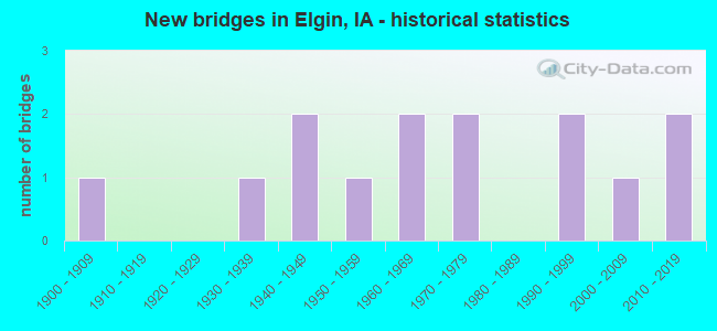
- New bridges - historical statistics
- 11900-1909
- 11930-1939
- 21940-1949
- 11950-1959
- 21960-1969
- 21970-1979
- 21990-1999
- 12000-2009
- 22010-2019

- Bridge Condition - Deck
- 10.0%Very good
- 30.0%Good
- 30.0%Satisfactory
- 30.0%Fair

- Bridge Condition - Superstructure
- 20.0%Very good
- 10.0%Good
- 60.0%Satisfactory
- 10.0%Fair

- Bridge Condition - Substructure
- 20.0%Very good
- 10.0%Good
- 30.0%Satisfactory
- 10.0%Fair
- 30.0%Poor

- Bridge Condition - Channel
- 21.4%Very good
- 57.1%Good
- 7.1%Satisfactory
- 14.3%Fair

- Bridge Condition - Culverts
- 75.0%Good
- 25.0%Satisfactory
Find on map >> Show street view
Structure Number: 45, Location: 000000000 (Lat: 42.952286, Lng: -91.643078), Route carried "on" structure: City street , Year Built: 1964, Status: Open, Structure Length: 3.47m (11.38ft), Average Daily Traffic: 940 (year 2021), Average Future Daily Traffic: 940 (year 2041), Features Intersected: OTTER CREEK, Facility Carried by Structure: CEDAR RD.
Minimum Vertical Clearance: 30+ m (98+ ft), Kilometerpoint: 0.682, Lanes on structure: 2, Owner: City or Municipal Highway Agency, Maintenance Responsibility: County Highway Agency, Approaching Roadway Width: 8.5m (27.9ft), Material/Design: Prestressed concrete, Design/Construction: Stringer/Multi-beam, Number Of Spans In Main Unit: 2, Length of Maximum Span: 20.7m (67.9ft), Curb or Sidewalk Widths: Left: 0.3m (1.0ft), Right: 0.3m (1.0ft), Curb-To-Curb Width: 8.5m (27.9ft), Out-to-Out Width: 9.1m (29.9ft)
Condition: Deck: Fair, Superstructure: Satisfactory, Substructure: Satisfactory, Channel: Satisfactory, Operating Rating: 51.1 metric tons, Method Used To Determine Operating Rating: Allowable Stress (AS), Inventory Rating: 25.1 metric tons, Method Used To Determine Inventory Rating: Allowable Stress (AS), Structural Evaluation: Equal to present minimum criteria, Deck Geometry: Somewhat better than minimum adequacy, Waterway Adequacy: Better than present minimum criteria, Approach Roadway Alignment: Equal to present desirable criteria, Designated Inspection Frequency: Every 24 months, Inspection Date: October 2021, Deck Structure Type: Concrete Cast-file-Place, Wearing Surface/Protective System: Wearing Surface: Monolithic Concrete
Find on map >> Show street view
Structure Number: 4511, Location: 094071400 (Lat: 42.956319, Lng: -91.626286), Route carried "on" structure: City street , Year Built: 2011, Status: Open, Structure Length: 3.75m (12.30ft), Average Daily Traffic: 360 (year 2017), Average Future Daily Traffic: 360 (year 2041), Design Load: HL 93, Features Intersected: OTTER CREEK, Facility Carried by Structure: MILL ST
Minimum Vertical Clearance: 30+ m (98+ ft), Kilometerpoint: 0.396, Lanes on structure: 2, Owner: City or Municipal Highway Agency, Maintenance Responsibility: County Highway Agency, Approaching Roadway Width: 10.4m (34.1ft), Material/Design: Prestressed concrete, Design/Construction: Stringer/Multi-beam, Number Of Spans In Main Unit: 1, Length of Maximum Span: 36.6m (120.1ft), Curb or Sidewalk Widths: Left: 1.5m (4.9ft), Right: 0.0m, Curb-To-Curb Width: 9.1m (29.9ft), Out-to-Out Width: 11.8m (38.7ft)
Condition: Deck: Good, Superstructure: Very good, Substructure: Very good, Channel: Very good, Operating Rating: 43.7 metric tons, Method Used To Determine Operating Rating: Assigned ratings based on Load and Resistance Factor Design (LRFD) reported by rating factor (RF) using HL93 loadings, Inventory Rating: 32.4 metric tons, Method Used To Determine Inventory Rating: Assigned ratings based on Load and Resistance Factor Design (LRFD) reported by rating factor (RF) using HL93 loadings, Structural Evaluation: Equal to present desirable criteria, Deck Geometry: Equal to present minimum criteria, Waterway Adequacy: Superior to present desirable criteria, Approach Roadway Alignment: Equal to present minimum criteria, Designated Inspection Frequency: Every 24 months, Inspection Date: October 2021, Deck Structure Type: Concrete Cast-file-Place, Wearing Surface/Protective System: Wearing Surface: Monolithic Concrete, Deck Protection: Epoxy Coated Reinforcing
Find on map >> Show street view
Structure Number: 12075, Location: 094061906 (Lat: 42.938872, Lng: -91.606533), Route carried "on" structure: County highway , Year Built: 1900, Status: Posted for load, Structure Length: 1.01m (3.31ft), Average Daily Traffic: 15 (year 2017), Average Future Daily Traffic: 15 (year 2040), Design Load: H 15, Features Intersected: STREAM, Facility Carried by Structure: A AVE
Minimum Vertical Clearance: 30+ m (98+ ft), Kilometerpoint: 7.681, Lanes on structure: 1, Owner: County Highway Agency, Approaching Roadway Width: 5.5m (18.0ft), Skew: 4 degrees, Material/Design: Steel, Design/Construction: Stringer/Multi-beam, Number Of Spans In Main Unit: 1, Length of Maximum Span: 10.1m (33.1ft), Curb-To-Curb Width: 4.9m (16.1ft), Out-to-Out Width: 5.6m (18.4ft)
Condition: Deck: Satisfactory, Superstructure: Satisfactory, Substructure: Satisfactory, Channel: Very good, Operating Rating: 7.1 metric tons, Method Used To Determine Operating Rating: Load and Resistance Factor Rating (LRFR) rating reported by rating factor(RF) method using HL-93 loadings, Inventory Rating: 5.5 metric tons, Method Used To Determine Inventory Rating: Load and Resistance Factor Rating (LRFR) rating reported by rating factor(RF) method using HL-93 loadings, Structural Evaluation: High priority of corrective action, Deck Geometry: High priority of corrective action, Waterway Adequacy: Better than present minimum criteria, Approach Roadway Alignment: Meets minimum limits, Bridge Posting: Required (Relationship of Operating Rating to Maximum Legal Load: > 39.9% below), Designated Inspection Frequency: Every 24 months, Inspection Date: October 2020, Deck Structure Type: Concrete Cast-file-Place, Wearing Surface/Protective System: Wearing Surface: Wood or Timber
Find on map >> Show street view
Structure Number: 12076, Location: 094061907 (Lat: 42.939350, Lng: -91.593442), Route carried "on" structure: County highway , Year Built: 1953, Status: Open, Structure Length: 0.82m (2.69ft), Average Daily Traffic: 70 (year 2013), Average Future Daily Traffic: 70 (year 2038), Design Load: H 20, Features Intersected: SM STREAM, Facility Carried by Structure: CHARIOT RD
Minimum Vertical Clearance: 30+ m (98+ ft), Kilometerpoint: 8.362, Lanes on structure: 2, Owner: County Highway Agency, Approaching Roadway Width: 7.6m (24.9ft), Material/Design: Concrete, Design/Construction: Culvert, Number Of Spans In Main Unit: 2, Length of Maximum Span: 3.7m (12.1ft)
Condition: Channel: Good, Culverts: Good, Operating Rating: 32.3 metric tons, Method Used To Determine Operating Rating: Field evaluation and documented engineering judgment, Inventory Rating: 32.3 metric tons, Method Used To Determine Inventory Rating: Field evaluation and documented engineering judgment, Structural Evaluation: Better than present minimum criteria, Waterway Adequacy: Better than present minimum criteria, Approach Roadway Alignment: Equal to present desirable criteria, Length Of Structure Improvement: 4.70m (15.42ft), Designated Inspection Frequency: Every 24 months, Inspection Date: November 2018, Bridge Improvement Cost: $34,000, Roadway Improvement Cost: $20,000
Find on map >> Show street view
Structure Number: 120771, Location: 094062003 (Lat: 42.947019, Lng: -91.585519), Route carried "on" structure: County highway , Year Built: 2002, Status: Open, Structure Length: 3.14m (10.30ft), Average Daily Traffic: 300 (year 2021), Truck Traffic: 19%, Average Future Daily Traffic: 300 (year 2040), Design Load: HS 20, Features Intersected: SAND CREEK, Facility Carried by Structure: AGATE RD
Minimum Vertical Clearance: 30+ m (98+ ft), Kilometerpoint: 1.851, Lanes on structure: 2, Owner: County Highway Agency, Approaching Roadway Width: 9.8m (32.2ft), Material/Design: Concrete continuous, Design/Construction: Slab, Number Of Spans In Main Unit: 3, Length of Maximum Span: 11.9m (39.0ft), Curb-To-Curb Width: 9.1m (29.9ft), Out-to-Out Width: 9.8m (32.2ft)
Condition: Deck: Good, Superstructure: Good, Substructure: Good, Channel: Good, Operating Rating: 80.4 metric tons, Method Used To Determine Operating Rating: Load Factor (LF), Inventory Rating: 48.2 metric tons, Method Used To Determine Inventory Rating: Load Factor (LF), Structural Evaluation: Better than present minimum criteria, Deck Geometry: Equal to present minimum criteria, Waterway Adequacy: Equal to present desirable criteria, Approach Roadway Alignment: Equal to present desirable criteria, Designated Inspection Frequency: Every 24 months, Inspection Date: October 2020, Deck Structure Type: Concrete Cast-file-Place, Wearing Surface/Protective System: Wearing Surface: Monolithic Concrete
Find on map >> Show street view
Structure Number: 120781, Location: 0.5 miles E Bugle Rd (Lat: 42.945486, Lng: -91.571678), Route carried "on" structure: County highway , Year Built: 2018, Status: Open, Structure Length: 3.35m (10.99ft), Average Daily Traffic: 300 (year 2021), Truck Traffic: 19%, Average Future Daily Traffic: 300 (year 2040), Design Load: HL 93, Features Intersected: STREAM, Facility Carried by Structure: B64 AGATE RD
Minimum Vertical Clearance: 30+ m (98+ ft), Kilometerpoint: 2.997, Lanes on structure: 2, Owner: County Highway Agency, Approaching Roadway Width: 11.0m (36.1ft), Skew: 3 degrees, Material/Design: Concrete, Design/Construction: Stringer/Multi-beam, Number Of Spans In Main Unit: 1, Length of Maximum Span: 33.5m (109.9ft), Curb-To-Curb Width: 9.1m (29.9ft), Out-to-Out Width: 10.1m (33.1ft)
Condition: Deck: Very good, Superstructure: Very good, Substructure: Very good, Channel: Very good, Operating Rating: 71.3 metric tons, Method Used To Determine Operating Rating: Load and Resistance Factor Rating (LRFR) rating reported by rating factor(RF) method using HL-93 loadings, Inventory Rating: 45.0 metric tons, Method Used To Determine Inventory Rating: Load and Resistance Factor Rating (LRFR) rating reported by rating factor(RF) method using HL-93 loadings, Structural Evaluation: Equal to present desirable criteria, Deck Geometry: Equal to present minimum criteria, Waterway Adequacy: Superior to present desirable criteria, Approach Roadway Alignment: Equal to present desirable criteria, Designated Inspection Frequency: Every 24 months, Inspection Date: October 2020, Deck Structure Type: Concrete Cast-file-Place, Wearing Surface/Protective System: Wearing Surface: Monolithic Concrete, Deck Protection: Epoxy Coated Reinforcing
Find on map >> Show street view
Structure Number: 120791, Location: 094062103 (Lat: 42.946367, Lng: -91.562931), Route carried "on" structure: County highway , Year Built: 1978, Status: Open, Structure Length: 0.85m (2.79ft), Average Daily Traffic: 300 (year 2021), Truck Traffic: 19%, Average Future Daily Traffic: 300 (year 2040), Design Load: H 20, Features Intersected: SMALL STREAM, Facility Carried by Structure: AGATE RD
Minimum Vertical Clearance: 30+ m (98+ ft), Kilometerpoint: 3.822, Lanes on structure: 2, Owner: County Highway Agency, Approaching Roadway Width: 10.4m (34.1ft), Skew: 3 degrees, Material/Design: Concrete, Design/Construction: Culvert, Number Of Spans In Main Unit: 2, Length of Maximum Span: 3.7m (12.1ft)
Condition: Channel: Good, Culverts: Good, Operating Rating: 32.3 metric tons, Method Used To Determine Operating Rating: Field evaluation and documented engineering judgment, Inventory Rating: 22.5 metric tons, Method Used To Determine Inventory Rating: Field evaluation and documented engineering judgment, Structural Evaluation: Equal to present minimum criteria, Waterway Adequacy: Equal to present desirable criteria, Approach Roadway Alignment: Equal to present minimum criteria, Length Of Structure Improvement: 4.70m (15.42ft), Designated Inspection Frequency: Every 24 months, Inspection Date: October 2020, Bridge Improvement Cost: $34,000, Roadway Improvement Cost: $20,000
Find on map >> Show street view
Structure Number: 151981, Location: 094071311 (Lat: 42.957144, Lng: -91.615842), Route carried "on" structure: County highway , Year Built: 1996, Status: Open, Structure Length: 1.34m (4.40ft), Average Daily Traffic: 610 (year 2021), Average Future Daily Traffic: 610 (year 2041), Design Load: HS 20, Features Intersected: TURKEY RIVER OVER FLOW, Facility Carried by Structure: AGATE RD
Minimum Vertical Clearance: 30+ m (98+ ft), Kilometerpoint: 0.653, Lanes on structure: 2, Owner: County Highway Agency, Approaching Roadway Width: 10.4m (34.1ft), Skew: 3 degrees, Material/Design: Concrete continuous, Design/Construction: Culvert, Number Of Spans In Main Unit: 2, Length of Maximum Span: 4.3m (14.1ft)
Condition: Channel: Fair, Culverts: Good, Operating Rating: 44.1 metric tons, Method Used To Determine Operating Rating: Field evaluation and documented engineering judgment, Inventory Rating: 32.7 metric tons, Method Used To Determine Inventory Rating: Field evaluation and documented engineering judgment, Structural Evaluation: Better than present minimum criteria, Waterway Adequacy: Better than present minimum criteria, Approach Roadway Alignment: Equal to present desirable criteria, Designated Inspection Frequency: Every 24 months, Inspection Date: October 2021, Deck Structure Type: Concrete Cast-file-Place
Find on map >> Show street view
Structure Number: 15199, Location: 094071503 (Lat: 42.952083, Lng: -91.654892), Route carried "on" structure: County highway , Year Built: 1932, Year Reconstructed: 1963, Status: Open, Structure Length: 0.64m (2.10ft), Average Daily Traffic: 930 (year 2021), Truck Traffic: 12%, Average Future Daily Traffic: 930 (year 2041), Features Intersected: UNNAMED CR, Facility Carried by Structure: GOLDEN RD.
Minimum Vertical Clearance: 30+ m (98+ ft), Kilometerpoint: 11.957, Lanes on structure: 2, Owner: County Highway Agency, Approaching Roadway Width: 10.4m (34.1ft), Skew: 3 degrees, Material/Design: Concrete, Design/Construction: Slab, Number Of Spans In Main Unit: 1, Length of Maximum Span: 6.1m (20.0ft), Curb-To-Curb Width: 9.1m (29.9ft), Out-to-Out Width: 9.6m (31.5ft)
Condition: Deck: Satisfactory, Superstructure: Satisfactory, Substructure: Satisfactory, Channel: Good, Operating Rating: 44.1 metric tons, Method Used To Determine Operating Rating: Field evaluation and documented engineering judgment, Inventory Rating: 32.7 metric tons, Method Used To Determine Inventory Rating: Field evaluation and documented engineering judgment, Structural Evaluation: Equal to present minimum criteria, Deck Geometry: Equal to present minimum criteria, Waterway Adequacy: Meets minimum limits, Approach Roadway Alignment: Equal to present desirable criteria, Designated Inspection Frequency: Every 24 months, Inspection Date: October 2021, Deck Structure Type: Concrete Cast-file-Place, Wearing Surface/Protective System: Wearing Surface: Bituminous
Find on map >> Show street view
Structure Number: 152001, Location: 094071504 (Lat: 42.951050, Lng: -91.652581), Route carried "on" structure: County highway , Year Built: 1990, Status: Open, Structure Length: 1.19m (3.90ft), Average Daily Traffic: 80 (year 2017), Average Future Daily Traffic: 80 (year 2041), Design Load: HS 20, Features Intersected: UNAMED CREEK, Facility Carried by Structure: ECHO VALLEY RD.
Minimum Vertical Clearance: 30+ m (98+ ft), Kilometerpoint: 14.642, Lanes on structure: 2, Owner: County Highway Agency, Approaching Roadway Width: 7.9m (25.9ft), Material/Design: Steel, Design/Construction: Culvert, Number Of Spans In Main Unit: 2, Length of Maximum Span: 3.7m (12.1ft)
Condition: Channel: Good, Culverts: Satisfactory, Operating Rating: 44.1 metric tons, Method Used To Determine Operating Rating: Field evaluation and documented engineering judgment, Inventory Rating: 32.7 metric tons, Method Used To Determine Inventory Rating: Field evaluation and documented engineering judgment, Structural Evaluation: Equal to present minimum criteria, Waterway Adequacy: Somewhat better than minimum adequacy, Approach Roadway Alignment: Equal to present desirable criteria, Designated Inspection Frequency: Every 24 months, Inspection Date: October 2021
Find on map >> Show street view
Structure Number: 15201, Location: 094072003 (Lat: 42.938778, Lng: -91.689653), Route carried "on" structure: County highway , Year Built: 1964, Status: Posted for load, Structure Length: 0.79m (2.59ft), Average Daily Traffic: 80 (year 2017), Average Future Daily Traffic: 80 (year 2041), Features Intersected: UNAMED CR, Facility Carried by Structure: ECHO VALLEY RD
Minimum Vertical Clearance: 30+ m (98+ ft), Kilometerpoint: 10.581, Lanes on structure: 2, Owner: County Highway Agency, Approaching Roadway Width: 7.3m (24.0ft), Skew: 2 degrees, Material/Design: Steel, Design/Construction: Stringer/Multi-beam, Number Of Spans In Main Unit: 1, Length of Maximum Span: 7.6m (24.9ft), Curb-To-Curb Width: 6.1m (20.0ft), Out-to-Out Width: 6.7m (22.0ft)
Condition: Deck: Good, Superstructure: Satisfactory, Substructure: Poor, Channel: Good, Operating Rating: 32.7 metric tons, Method Used To Determine Operating Rating: Load Factor (LF), Inventory Rating: 19.6 metric tons, Method Used To Determine Inventory Rating: Load Factor (LF), Structural Evaluation: Meets minimum limits, Deck Geometry: Somewhat better than minimum adequacy, Waterway Adequacy: Better than present minimum criteria, Approach Roadway Alignment: High priority of corrective action, Bridge Posting: Required (Relationship of Operating Rating to Maximum Legal Load: 0.1 - 9.9% below), Length Of Structure Improvement: 2.30m (7.55ft), Designated Inspection Frequency: Every 24 months, Inspection Date: October 2021, Bridge Improvement Cost: $32,000, Roadway Improvement Cost: $2,000, Deck Structure Type: Concrete Cast-file-Place
Find on map >> Show street view
Structure Number: 15203, Location: 094072401 (Lat: 42.945344, Lng: -91.613464), Route carried "on" structure: County highway , Year Built: 1949, Status: Posted for load, Structure Length: 1.59m (5.22ft), Average Daily Traffic: 130 (year 2017), Average Future Daily Traffic: 130 (year 2041), Features Intersected: BEAVER CREEK, Facility Carried by Structure: ABBEY RD.
Minimum Vertical Clearance: 30+ m (98+ ft), Kilometerpoint: 1.405, Lanes on structure: 2, Owner: County Highway Agency, Approaching Roadway Width: 7.9m (25.9ft), Material/Design: Steel, Design/Construction: Stringer/Multi-beam, Number Of Spans In Main Unit: 2, Length of Maximum Span: 7.9m (25.9ft), Curb or Sidewalk Widths: Left: 0.3m (1.0ft), Right: 0.3m (1.0ft), Curb-To-Curb Width: 6.8m (22.3ft), Out-to-Out Width: 7.3m (24.0ft)
Condition: Deck: Satisfactory, Superstructure: Satisfactory, Substructure: Poor, Channel: Good, Operating Rating: 51.5 metric tons, Method Used To Determine Operating Rating: Load Factor (LF), Inventory Rating: 30.8 metric tons, Method Used To Determine Inventory Rating: Load Factor (LF), Structural Evaluation: Meets minimum limits, Deck Geometry: Meets minimum limits, Waterway Adequacy: Equal to present desirable criteria, Approach Roadway Alignment: High priority of corrective action, Bridge Posting: Required (Relationship of Operating Rating to Maximum Legal Load: 30.0 - 39.9% below), Length Of Structure Improvement: 10.00m (32.81ft), Designated Inspection Frequency: Every 24 months, Inspection Date: October 2021, Bridge Improvement Cost: $125,000, Roadway Improvement Cost: $10,000, Deck Structure Type: Concrete Cast-file-Place
Find on map >> Show street view
Structure Number: 15204, Location: 094072404 (Lat: 42.938419, Lng: -91.625989), Route carried "on" structure: County highway , Year Built: 1941, Status: Posted for load, Structure Length: 1.28m (4.20ft), Average Daily Traffic: 180 (year 2021), Truck Traffic: 26%, Average Future Daily Traffic: 180 (year 2041), Features Intersected: BEAVER CREEK, Facility Carried by Structure: ACORN RD.
Minimum Vertical Clearance: 30+ m (98+ ft), Kilometerpoint: 12.723, Lanes on structure: 2, Owner: County Highway Agency, Approaching Roadway Width: 6.4m (21.0ft), Material/Design: Steel, Design/Construction: Stringer/Multi-beam, Number Of Spans In Main Unit: 1, Length of Maximum Span: 12.8m (42.0ft), Curb or Sidewalk Widths: Left: 0.2m (0.7ft), Right: 0.2m (0.7ft), Curb-To-Curb Width: 6.6m (21.7ft), Out-to-Out Width: 7.1m (23.3ft)
Condition: Deck: Fair, Superstructure: Satisfactory, Substructure: Poor, Channel: Good, Operating Rating: 37.1 metric tons, Method Used To Determine Operating Rating: Load Factor (LF), Inventory Rating: 22.2 metric tons, Method Used To Determine Inventory Rating: Load Factor (LF), Structural Evaluation: Meets minimum limits, Deck Geometry: Meets minimum limits, Waterway Adequacy: Better than present minimum criteria, Approach Roadway Alignment: Equal to present desirable criteria, Bridge Posting: Required (Relationship of Operating Rating to Maximum Legal Load: > 39.9% below), Length Of Structure Improvement: 4.00m (13.12ft), Designated Inspection Frequency: Every 24 months, Inspection Date: November 2021, Bridge Improvement Cost: $125,000, Roadway Improvement Cost: $15,000, Deck Structure Type: Concrete Cast-file-Place, Wearing Surface/Protective System: Wearing Surface: Bituminous
Find on map >> Show street view
Structure Number: 152051, Location: 094072904 (Lat: 42.928753, Lng: -91.696972), Route carried "on" structure: County highway , Year Built: 1972, Status: Posted for load, Structure Length: 1.83m (6.00ft), Average Daily Traffic: 20 (year 2021), Average Future Daily Traffic: 20 (year 2041), Features Intersected: OTTER CREEK, Facility Carried by Structure: DOVE RD.
Minimum Vertical Clearance: 30+ m (98+ ft), Kilometerpoint: 0.175, Lanes on structure: 2, Owner: County Highway Agency, Approaching Roadway Width: 7.3m (24.0ft), Material/Design: Steel, Design/Construction: Truss - Thru, Number Of Spans In Main Unit: 1, Length of Maximum Span: 18.3m (60.0ft), Curb-To-Curb Width: 6.4m (21.0ft), Out-to-Out Width: 6.5m (21.3ft)
Condition: Deck: Fair, Superstructure: Fair, Substructure: Fair, Channel: Fair, Operating Rating: 23.8 metric tons, Method Used To Determine Operating Rating: Load Factor (LF), Inventory Rating: 14.2 metric tons, Method Used To Determine Inventory Rating: Load Factor (LF), Structural Evaluation: Meets minimum limits, Deck Geometry: Somewhat better than minimum adequacy, Waterway Adequacy: Superior to present desirable criteria, Approach Roadway Alignment: Equal to present desirable criteria, Bridge Posting: Required (Relationship of Operating Rating to Maximum Legal Load: 20.0 - 29.9% below), Length Of Structure Improvement: 10.00m (32.81ft), Designated Inspection Frequency: Every 24 months, Critical Feature Inspection Frequency: Every 24 months, Inspection Date: October 2021, Critical Feature Inspection Date: October 2021, Bridge Improvement Cost: $145,000, Roadway Improvement Cost: $5,000, Deck Structure Type: Wood or Timber, Wearing Surface/Protective System: Wearing Surface: Gravel